Earthquakes around the world

23 May,Updated: May 24 Bárðarbunga Volcano Trembles,link:
http://icelandreview.com/news/2016/05/24/bardarbunga-volcano-trembles
"An earthquake of magnitude 3.4 registered 6 km east-south-east of Bárðarbunga volcano at 5:37 yesterday, mbl.is reports. Only a week ago, the volcano made headlines with the largest earthquake since the end of the Holuhraun eruption in February of last year. That earthquake was of magnitude 4.4.

A total of 45 earthquakes in excess of magnitude 3 have registered in the area since February, 2015.

Scientists do not believe the tremors to foreshadow an eruption.

Bárðarbunga is located under the ice cap of Vatnajökull glacier. A small eruption there in August of 2014 was followed by the Holuhraun eruption nearby, which produced more lava than most volcanic eruptions in the history of Iceland."
 
M 5.4 - CRETE, GREECE - 2016-05-25 08:36:14 UTC
http://www.emsc-csem.org/Earthquake/earthquake.php?id=508496

M 3.9 - CRETE, GREECE - 2016-05-25 08:46:02 UTC
http://www.emsc-csem.org/Earthquake/earthquake.php?id=508500

M 3.9 - SOUTHERN GREECE - 2016-05-25 10:00:13 UTC
http://www.emsc-csem.org/Earthquake/earthquake.php?id=508504
 
They’re not huge - no bigger than M3.6 - but check out these quakes in succession at the British Virgin Islands from today - i've left in those registered in between to give an idea:
2.7 84km N of Road Town, British Virgin Islands 2016-05-25 08:15:11 UTC 43.0 km

2.7 86km N of Road Town, British Virgin Islands 2016-05-25 08:03:16 UTC 49.0 km

3.2 37km N of Road Town, British Virgin Islands 2016-05-25 07:23:56 UTC 92.0 km

2.7 86km N of Road Town, British Virgin Islands 2016-05-25 07:04:39 UTC 44.0 km

2.8 84km N of Road Town, British Virgin Islands 2016-05-25 07:01:36 UTC 45.0 km

3.1 86km N of Road Town, British Virgin Islands 2016-05-25 06:44:51 UTC 24.0 km

3.2 58km NE of Miches, Dominican Republic 2016-05-25 06:29:18 UTC 111.0 km

4.2 9km NNE of Piedra Blanca, Dominican Republic 2016-05-25 06:16:40 UTC 77.3 km

2.9 31km NW of Fairview, Oklahoma 2016-05-25 06:09:59 UTC 10.1 km

2.6 82km N of Road Town, British Virgin Islands 2016-05-25 06:01:57 UTC 48.0 km

2.6 55km SW of Ferndale, California 2016-05-25 05:49:00 UTC 18.7 km

2.5 89km N of Road Town, British Virgin Islands 2016-05-25 05:43:52 UTC 24.0 km

3.2 91km N of Road Town, British Virgin Islands 2016-05-25 05:42:12 UTC 24.0 km

3.6 89km N of Road Town, British Virgin Islands 2016-05-25 05:30:36 UTC 24.0 km

2.7 77km NNE of Luquillo, Puerto Rico 2016-05-25 04:53:51 UTC 51.0 km

3.1 92km N of Road Town, British Virgin Islands 2016-05-25 04:27:06 UTC 24.0 km
 
Andre' said:
Fiji Islands: earthquake 6.4 M at a depth of 570 Km, this morning.

This is now up on sott: https://www.sott.net/article/319083-6-5-earthquake-strikes-off-Fiji-coast

Also, to note, there have been 47 earthquakes in the last 24hours - with a daily average of ~30. Others of note:
5.2 66km SSE of Kokopo, Papua New Guinea 2016-05-27 15:03:44 UTC 59.7 km

4.4 98km E of Pagan, Northern Mariana Islands 2016-05-27 14:21:05 UTC 52.2 km

4.7 103km NNE of Tobelo, Indonesia 2016-05-27 13:39:49 UTC 123.2 km

5.2 13km WNW of Campoverde, Peru 2016-05-27 10:00:49 UTC 132.4 km

2.6 82km N of Road Town, British Virgin Islands 2016-05-27 06:45:49 UTC 43.0 km

3.4 39km E of Road Town, British Virgin Islands 2016-05-27 05:48:02 UTC 137.0 km

5.0 96km NW of Port-Vila, Vanuatu 2016-05-27 05:31:23 UTC 10.0 km

4.6 103km ESE of Khonsa, India 2016-05-27 05:03:11 UTC 74.8 km

2.5 94km NNW of Road Town, British Virgin Islands 2016-05-27 04:33:49 UTC 24.0 km

2.7 97km NNW of Road Town, British Virgin Islands 2016-05-27 04:17:42 UTC 30.0 km

2.7 84km NNW of Road Town, British Virgin Islands 2016-05-27 04:14:36 UTC 50.0 km

3.5 95km N of Road Town, British Virgin Islands 2016-05-27 04:12:26 UTC 31.0 km

6.4 19km S of Ndoi Island, Fiji 2016-05-27 04:08:44 UTC 572.1 km [mentioned above]

2.7 89km NNW of Road Town, British Virgin Islands 2016-05-27 04:08:34 UTC 43.0 km

2.6 89km NNW of Road Town, British Virgin Islands 2016-05-27 04:07:33 UTC 50.0 km

4.7 172km SSE of Naze, Japan 2016-05-27 03:58:43 UTC 10.0 km

5.8 168km SSE of Naze, Japan 2016-05-27 03:44:29 UTC 10.0 km

4.5 5km SSE of Lukatan, Philippines 2016-05-27 03:25:51 UTC 27.0 km

3.3 97km NNW of Road Town, British Virgin Islands 2016-05-27 03:20:46 UTC 36.0 km

3.4 90km N of Road Town, British Virgin Islands 2016-05-27 02:38:43 UTC 47.0 km

4.5 South of the Fiji Islands 2016-05-26 21:52:01 UTC 538.4 km

4.8 54km W of Coquimbo, Chile 2016-05-26 20:36:49 UTC 12.0 km

4.5 134km SSE of Shizunai, Japan 2016-05-26 20:07:51 UTC 46.0 km

4.8 235km SE of Vostok, Russia 2016-05-26 20:00:56 UTC 10.0 km

2.8 96km N of Road Town, British Virgin Islands 2016-05-26 19:57:10 UTC 36.0 km

2.8 82km NNW of Road Town, British Virgin Islands 2016-05-26 19:51:57 UTC 58.0 km

This may have something to do with the coronal hole stream which should be arriving
http://www.spaceweather.com/ said:
CHANCE OF MINOR STORMS: NOAA forecasters estimate a 35% chance of minor G1-class geomagnetic storms on May 27th when Earth enters a high-speed stream of solar wind. High-latitude sky watchers should be alert for auroras, especially in the southern hemisphere where darkening autumn skies favor visibility of faint lights. Aurora alerts: text, voice.

There's some related discussion here: Sol (Sun) and it's phenomena

Laura said:
[...]
While the cause of coronal holes remains a mystery, they “correlate to areas on the sun where magnetic fields soar up and away, without looping back down to the surface, as they do elsewhere.”

Question is: where is that current flow going??? That's a pretty huge coronal hole.

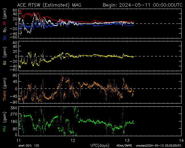
And the activity looks to be increasing right now, as shown on the chart below, and explained by Mrkrhnr
[...]"When the speed (yellow, fourth panel) and density (orange, third panel) are high, and often when the Bz component of the magnetic field (red, first panel) goes negative with a high amplitude, there is more seismic activity or weather extremes. That's my limited observation FWIW.

They're not the only factors of course.

ace-mag-3-day.gif
Also noted on Spaceweather:
NOCTILUCENT CLOUD SEASON BEGINS: NASA's AIM spacecraft has spotted wispy patches of electric-blue drifting over the Arctic Ocean. The sighting marks the beginning of the 2016 season for noctilucent clouds (NLCs). "The first clouds appeared on May 24th--about the same as previous years," reports Cora Randall, AIM science team member at the University of Colorado. The clouds are boxed in this polar image recorded by AIM's CIPS instrument:

These first detections from space are small and faint. They won't remain faint for long, however. Previous data from AIM have shown that NLCs are like a great "geophysical light bulb." They turn on every year in late spring, reaching almost full intensity over a period of 5 to 10 days. This means observers on the ground should soon begin to see them.

Indeed, just this morning, May 27th, Mike Griffiths of Llanfairfechan, North Wales, UK, spotted some NLCs peeking over the northern horizon:
Mike-Griffiths-image_1464344663_lg.jpg

"I saw our first NLCs of the season!" says Griffiths.

NLCs are Earth's highest clouds. Seeded by meteoroids, they float at the edge of space more than 80 km above the planet's surface. The clouds are very cold and filled with tiny ice crystals. When sunbeams hit those crystals, they glow electric-blue.

Noctilucent clouds first appeared in the 19th century after the eruption of super-volcano Krakatoa. At the time, people thought the clouds were caused by the eruption, but long after Krakatoa's ash settled, the clouds remained. In those days, NLCs were a polar phenomenon confined mainly to the Arctic. In recent years they have intensified and spread with sightings as far south as Utah and Colorado. Some researchers believe the intensification is a sign of climate change.

Early-season NLCs are always found at high-latitudes--e.g., Canada, the British isles, Siberia and Scandinavia. To people in those areas, we offer the following observing tips: Look west 30 to 60 minutes after sunset when the sun has dipped 6o to 16o below the horizon. If you see luminous blue-white tendrils spreading across the sky, you may have spotted a noctilucent cloud.
 
Just saw this on RT:Quake in South Georgia - sub Antarctic Islands...

7.2-magnitude quake hits Antarctic
A 7.2-magnitude quake hit over 90km deep under the southern Atlantic Ocean 58km from Visokoi Island, the USGS reported. The island belongs to the Antarctic South Georgia and the South Sandwich Islands. No tsunami advisory was issued.

https://www.rt.com/news/line/
 
Mr.Cyan said:
Just saw this on RT:Quake in South Georgia - sub Antarctic Islands...

7.2-magnitude quake hits Antarctic
[...]

Next to the British Virgin Island shaking, the US Virgin Islands are now in on the action, Australia seems to be making some moves, and there was another large quake in Fiji, an M6.6.

The KP index is pretty stable but the gif attached to the previous message shows shifts.

4.8 166km NNE of Esperance, Australia 2016-05-28 16:38:44 UTC 8.7 km

4.8 170km NNE of Esperance, Australia 2016-05-28 15:30:26 UTC 9.7 km

2.9 84km N of Charlotte Amalie, U.S. Virgin Islands 2016-05-28 13:45:13 UTC 75.0 km

3.7 118km N of San Juan, Puerto Rico 2016-05-28 11:35:29 UTC 62.0 km

2.5 45km SSW of Redoubt Volcano, Alaska 2016-05-28 09:55:29 UTC 115.5 km

7.2 58km NNE of Visokoi Island, South Georgia and the South Sandwich Islands 2016-05-28 09:46:59 UTC 72.7 km (noted above and on sott: https://www.sott.net/article/319136-USGS-Magnitude-7-3-earthquake-hits-South-Atlantic-near-Antarctica)

4.7 34km NNW of Nagarkot, Nepal 2016-05-28 09:39:10 UTC 10.0 km

4.6 71km N of Hachijo-jima, Japan 2016-05-28 09:01:26 UTC 150.3 km

2.6 85km N of Road Town, British Virgin Islands 2016-05-28 08:47:37 UTC 15.0 km

2.6 82km N of Road Town, British Virgin Islands 2016-05-28 08:38:25 UTC 10.0 km

6.6 161km SSE of Ndoi Island, Fiji 2016-05-28 05:38:51 UTC 416.8 km

Andre' said:
Fiji Islands: earthquake 6.4 M at a depth of 570 Km, this morning.

5.2 Central Mid-Atlantic Ridge 2016-05-28 04:43:30 UTC 10.0 km
 
5.0 119km E of Aileu, East Timor 2016-05-28 21:03:23 UTC 39.8 km

4.3 189km NE of Ndoi Island, Fiji 2016-05-28 20:16:04 UTC 558.5 km

4.7 137km NNE of Visokoi Island, South Georgia and the South Sandwich Islands 2016-05-28 17:12:23 UTC 24.1 k
 
Since the last update - two above M4 in Algeria, one in China and Afghanistan of note.
USGS said:
Today said:
3.6 23km S of Alberto Oviedo Mota, B.C., MX 2016-05-29 08:27:33 UTC 1.4 km

4.5
4km NE of `Alaqahdari-ye Kiran wa Munjan, Afghanistan 2016-05-29 06:45:59 UTC 92.0 km

4.3 9km SSE of Boyuibe, Bolivia 2016-05-29 06:34:13 UTC 562.9 km

5.0 Northern Mid-Atlantic Ridge 2016-05-29 05:58:39 UTC 10.0 km

4.2 14km W of Ain Bessem, Algeria 2016-05-29 05:23:10 UTC 10.0 km

4.5 162km ESE of Hasaki, Japan 2016-05-29 05:22:09 UTC 10.0 km

4.4 159km W of Sabtang, Philippines 2016-05-29 05:10:48 UTC 10.0 km

4.2 10km WSW of Huagai, China 2016-05-29 02:14:37 UTC 10.0 km

4.9 75km S of Lakatoro, Vanuatu 2016-05-29 00:43:07 UTC 10.0 km

4.3 43km NW of Kizukuri, Japan 2016-05-29 00:24:42 UTC 158.6 km

4.3 55km WSW of Puerto Madero, Mexico 2016-05-29 00:20:19 UTC 35.0 km

Yesterday said:
5.2 19km SSW of Lakhdaria, Algeria 2016-05-28 23:54:53 UTC 11.9 km
 
There is a minor quake reported within Germany with a strength of 3,4 in Bottrop which is in the Ruhr region of Germany. Only minor damages are reported.
 
Strongest earthquake in six years hits Norseman, Western Australia

_http://strangesounds.org/2016/05/strongest-earthquake-in-six-years-hits-norseman-western-australia.html

A magnitude 5.2 quake – the strongest earthquake since 2010 – hit Norseman, Western Australia on May 28, 2016.

People as far away as Perth and Esperance reported feeling the earth shake.
The major quake was followed by two weaker tremors. The first M4.9 earthquake hit at about 11.30pm, about 6km below the earth’s surface. It was followed by a 5.2-magnitude quake, that was felt as far away as Perth and a 3.2-magnitude aftershock. More aftershocks are forecast for the coming weeks.

The quakes’ epicentre had been far enough from settlements not to cause any danger.

Western Australia’s largest-ever earthquake was a 6.5-magnitude shock in Meckering in 1968, but this one had been the largest since 2010’s 5.0 quake in Kalgoorlie.
 
Shared Joy said:
Strongest earthquake in six years hits Norseman, Western Australia

A magnitu[...]

And from today, all the most recent and in order - pretty large:
USGS said:
5.4 116km S of Raoul Island, New Zealand 2016-05-30 10:55:17 UTC 29.1 km

5.2
126km ESE of Hirara, Japan 2016-05-30 09:47:47 UTC 10.0 km

5.2
Southern Mid-Atlantic Ridge 2016-05-30 07:35:58 UTC 14.2 km

4.8 123km E of L'Esperance Rock, New Zealand 2016-05-30 07:24:12 UTC 35.0 km

5.7 123km S of Raoul Island, New Zealand 2016-05-30 07:14:16 UTC 32.2 km
 
M 6.3 - TAIWAN REGION - 2016-05-31 05:23:47 UTC
http://www.emsc-csem.org/Earthquake/earthquake.php?id=509576
 
casper said:
M 6.3 - TAIWAN REGION - 2016-05-31 05:23:47 UTC
http://www.emsc-csem.org/Earthquake/earthquake.php?id=509576
Or :
M 7.2 ?
http://www.cwb.gov.tw/V7e/earthquake/Data/quake/EE0531132372077.htm
 
21 quakes in the last ~ 24 hours and eleven are over M4

USGS said:
5.5 Kuril Islands 2016-05-31 10:03:59 UTC 10.0 km

6.1 92km ENE of Keelung, Taiwan 2016-05-31 05:23:47 UTC 242.9 km [as posted by Casper]

4.9 94km NE of Visokoi Island, South Georgia and the South Sandwich Islands 2016-05-31 04:32:15 UTC 10.0 km

4.7 98km S of La Libertad, El Salvador 2016-05-31 02:14:42 UTC 45.1 km

4.4 33km W of Andalgala, Argentina 2016-05-31 01:53:12 UTC 27.1 km

4.1 24km S of King Salmon, Alaska 2016-05-31 01:42:25 UTC 207.7 km

5.1 88km SE of Amahai, Indonesia 2016-05-30 22:27:32 UTC 10.0 km

4.1 96km SE of Old Iliamna, Alaska 2016-05-30 19:01:30 UTC 96.6 km

4.6 154km SW of Kavieng, Papua New Guinea 2016-05-30 16:27:30 UTC 10.0 km

4.6 South Shetland Islands 2016-05-30 15:35:09 UTC 10.0 km

4.5 100km NE of Tobelo, Indonesia 2016-05-30 12:46:17 UTC 230.6 km

4.9
26km W of Illapel, Chile 2016-05-30 12:41:55 UTC 51.5 km
 
Back
Top Bottom