You are using an out of date browser. It may not display this or other websites correctly.
You should upgrade or use an alternative browser.
You should upgrade or use an alternative browser.
Crazy Storm Weather and Lightning - Global
- Thread starter mabar
- Start date
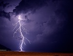
Is this strike genuine or simply surreal?
Severe Weather in Europe: Large Hail and Heavy Rain Expected Across Europe
Valid: Fri 21 Jun 2019 06:00 to Sat 22 Jun 2019 06:00 UTC Issued: Thu 20 Jun 2019 18:57 Forecaster: GROENEMEIJER A level 2 was issued for parts of Northwest ...
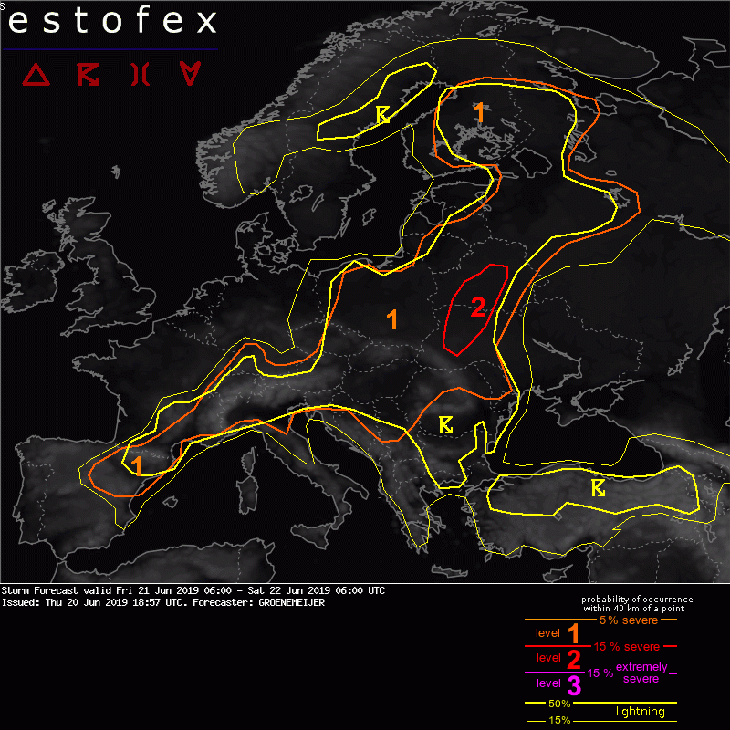
SYNOPSIS
A southwesterly flow persists over a large part of western, central and northern Europe. A trough initially over Scotland moves to the northern Baltic Sea. Ahead of it, a surface cyclone should develop over North Sweden. A fairly humid and warm air-mass resides over Finland, the Baltic States into central Europe. Within this air-mass, scattered to widespread storms are expected to develop on Friday, as low to moderate CAPE develops.
Upstream, a local vorticity maximum over the Bay of Biscay moves slowly eastward and reaches central France on Saturday morning. Isolated to scattered storms are expected to develop over Southeast France and Northeast Spain.
DISCUSSION
Finland, Russian Karelia.
NE Spain, SE France
North Italy, Slovenia, North Croatia
The Alps
Turkey
Sweden
06-20-19 Rushville, NE - Mothership Structure Timelapse Hail
Translated from French by Microsoft
The first#orages ones now erupt on the #MassifCentral and especially in the area where #ClermontFerrand the de la is #grêle reported. Webcam view of the A71 motorway north of Clermont (@VoyageAPRR)
Electric night on Lake Geneva. Lightning branched near Villeneuve (Vaud), last night. Lightning over lake Geneva last night.
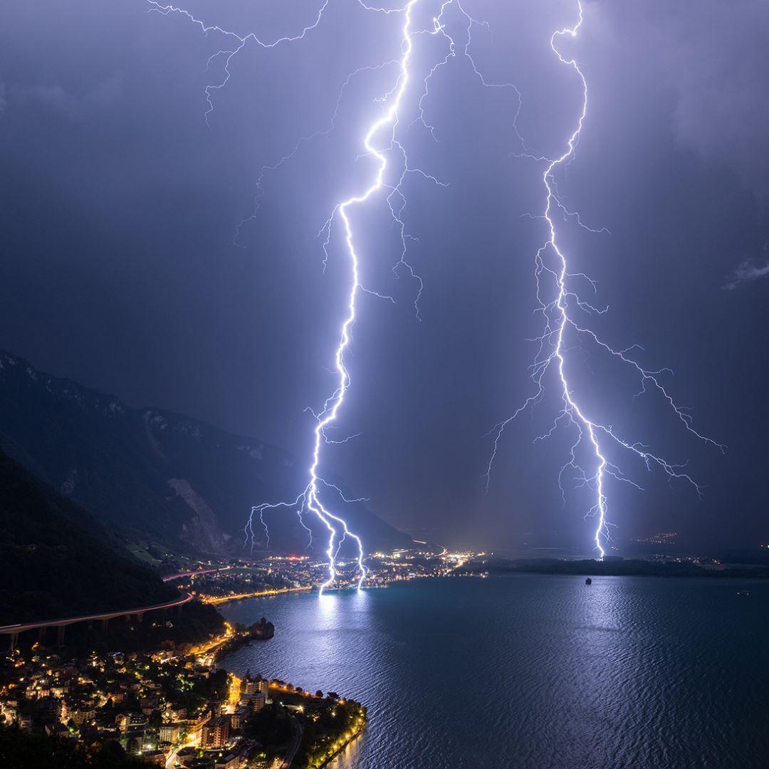
June 30th by Christophe Suarez!
The first
Electric night on Lake Geneva. Lightning branched near Villeneuve (Vaud), last night. Lightning over lake Geneva last night.
June 30th by Christophe Suarez!
angelburst29
The Living Force
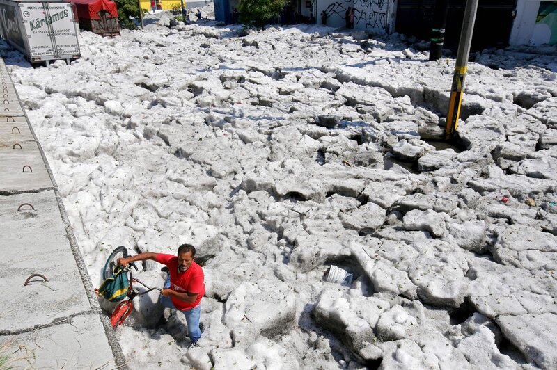
Freak hailstorm engulfs trucks in Mexican city June 30, 2019

Drifts of hail from a freak storm partially buried tractor-trailers and cars in the Mexican city of Guadalajara, bringing families out on to the streets to play in ice piled high despite the summer heat.
The storm on Sunday blanketed parts of Mexico’s second largest city in white. Soldiers and police who took to the streets to help the clear-up operations slid and slipped knee deep into the drifts.
Jorge David Arias, who was visiting family, said he and his relatives had never seen a storm like it. Arias shot photos showing cars pushed against trees by the force of the ice.
Guadalajara, in western Mexico, usually sees average temperatures in June of around 31 Celsius (88 Fahrenheit).
Freak Summer Hail Storm Blankets Mexico's Guadalajara
NPR Choice page
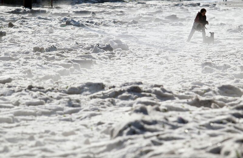
Vehicles were buried in hail on Sunday (June 30) in eastern Guadalajara in Mexico's Jalisco state. The accumulation of hail buried vehicles and damaged homes.
People in Guadalajara, Mexico, woke up on Sunday to a thick blanket of ice over areas of their city, after a freak hail storm that damaged houses and left cars partially buried.
This is particularly strange because it's the middle of summer. In the past month, temperatures most days have hit 90 degrees Fahrenheit or over.
The Mexican army and local authorities have been deployed to use heavy machinery to dig out the city of nearly 1.5 million people that is the capital of Jalisco state.
"Hail more than a meter high and then we wonder if climate change exists," Jalisco Gov. Enrique Alfaro Ramírez wrote on Twitter. As of Sunday afternoon, no injuries had been reported, he said, adding that authorities were working to help citizens whose homes were damaged.
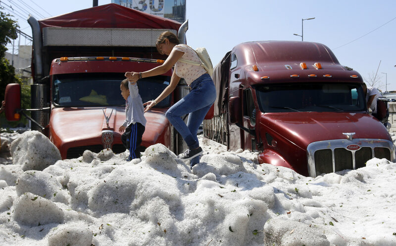
The blanket of hail made it difficult to get around the Mexican city of Guadalajara on Sunday.
"This is a natural phenomenon that we haven't seen before," the governor said in a video posted to Facebook. As he gestured to the blanketed street, he added: "The hail looks like snowfall."
In the Rancho Blanco area of the city, which was particularly hard-hit, some 30 vehicles and 60 homes were damaged, Jalisco Civil Protection officials said on Facebook.
It's worth noting that the actual hailstones that hit Guadalajara were rather small — even smaller than a marble, according to the BBC — which might have limited some of the damage.
June is typically one of the hottest months of the year in Guadalajara. Ulises Ruiz/AFP/Getty Images
Hail forms when "thunderstorm updrafts are strong enough to carry water droplets well above the freezing level," according to NASA. These droplets freeze into hailstones that fall to earth.
A woman and a child walk on hail in eastern Guadalajara on Sunday. Ulises Ruiz/AFP/Getty Images
A CNN meteorologist said a low pressure zone around the U.S.-Mexico border contributed to storm strengthening in the area. "This was a case where atmospheric and topographic ingredients came into play to cause a freakish hail storm," Michael Guy said.
As crews work to clear away the ice, they may get a hand from the weather. Guadalajara is expected to see significant melting on Monday, with likely thunderstorms and temperatures forecast to reach 81 degrees Fahrenheit.
Freak hail storm strikes Mexican city of Guadalajara (Video)
While seasonal hail storms do occur, there is no record of anything so heavy.
In a rare, massive hailstorm, six suburbs in Guadalajara, Mexico, were carpeted in thick snow on June 30, 2019. The ice rose up to five feet (1.5 meters) in some places, nearly burying vehicles on the roads.
~~~~~
Hailstorms July 1st in Austria, Czech Republic, Germany and Italy.
https://twitter.com/severeweatherEU/status/1145743914302922753
Drifts of hail from a freak storm partially buried tractor-trailers and cars in the Mexican city of Guadalajara, bringing families out on to the streets to play in ice piled high despite the summer heat.
The storm on Sunday blanketed parts of Mexico’s second largest city in white. Soldiers and police who took to the streets to help the clear-up operations slid and slipped knee deep into the drifts.
Jorge David Arias, who was visiting family, said he and his relatives had never seen a storm like it. Arias shot photos showing cars pushed against trees by the force of the ice.
Guadalajara, in western Mexico, usually sees average temperatures in June of around 31 Celsius (88 Fahrenheit).
Freak Summer Hail Storm Blankets Mexico's Guadalajara
NPR Choice page
Vehicles were buried in hail on Sunday (June 30) in eastern Guadalajara in Mexico's Jalisco state. The accumulation of hail buried vehicles and damaged homes.
People in Guadalajara, Mexico, woke up on Sunday to a thick blanket of ice over areas of their city, after a freak hail storm that damaged houses and left cars partially buried.
This is particularly strange because it's the middle of summer. In the past month, temperatures most days have hit 90 degrees Fahrenheit or over.
The Mexican army and local authorities have been deployed to use heavy machinery to dig out the city of nearly 1.5 million people that is the capital of Jalisco state.
"Hail more than a meter high and then we wonder if climate change exists," Jalisco Gov. Enrique Alfaro Ramírez wrote on Twitter. As of Sunday afternoon, no injuries had been reported, he said, adding that authorities were working to help citizens whose homes were damaged.
The blanket of hail made it difficult to get around the Mexican city of Guadalajara on Sunday.
"This is a natural phenomenon that we haven't seen before," the governor said in a video posted to Facebook. As he gestured to the blanketed street, he added: "The hail looks like snowfall."
In the Rancho Blanco area of the city, which was particularly hard-hit, some 30 vehicles and 60 homes were damaged, Jalisco Civil Protection officials said on Facebook.
It's worth noting that the actual hailstones that hit Guadalajara were rather small — even smaller than a marble, according to the BBC — which might have limited some of the damage.
June is typically one of the hottest months of the year in Guadalajara. Ulises Ruiz/AFP/Getty Images
Hail forms when "thunderstorm updrafts are strong enough to carry water droplets well above the freezing level," according to NASA. These droplets freeze into hailstones that fall to earth.
A woman and a child walk on hail in eastern Guadalajara on Sunday. Ulises Ruiz/AFP/Getty Images
A CNN meteorologist said a low pressure zone around the U.S.-Mexico border contributed to storm strengthening in the area. "This was a case where atmospheric and topographic ingredients came into play to cause a freakish hail storm," Michael Guy said.
As crews work to clear away the ice, they may get a hand from the weather. Guadalajara is expected to see significant melting on Monday, with likely thunderstorms and temperatures forecast to reach 81 degrees Fahrenheit.
Freak hail storm strikes Mexican city of Guadalajara (Video)
While seasonal hail storms do occur, there is no record of anything so heavy.
In a rare, massive hailstorm, six suburbs in Guadalajara, Mexico, were carpeted in thick snow on June 30, 2019. The ice rose up to five feet (1.5 meters) in some places, nearly burying vehicles on the roads.
~~~~~
Hailstorms July 1st in Austria, Czech Republic, Germany and Italy.
https://twitter.com/severeweatherEU/status/1145743914302922753
Barbara formed far off the southern coast of Mexico on Sunday. Barbara intensified into a Category 1 hurricane on Monday. Barbara is forecast to become the first major hurricane of the 2019 Eastern Pacific Hurricane Season.
As of the latest hurricane center update, Barbara has maximum winds of 85 mph. Barbara was located about 970 miles southwest of Baja California. The minimum central pressure continues to fall, now at 983 mb. The storm is moving to the W at roughly 16 mph.
During intensification on Monday, the storm has shown improved structure and the beginnings of an eye. The storm remains in favorable conditions for rapid intensification. The National Hurricane Center intensity forecast has been adjusted, forecasting Barbara to become a major hurricane by Tuesday afternoon. After several days of likely intensification, the system will likely encounter some dry air and shear. This will cause the system to weaken and eventually fall apart by the upcoming weekend.
Barbara is the second named storm of the Pacific season, and has brought the relatively slow start to the E. Pacific hurricane season up to speed. It is typical by late June to have had about 2 named storms. The first storm, Alvin, formed on June 25, which briefly strengthened to a hurricane.
Alvin and Barbara are the first 2 names on the list for the Eastern Pacific. The next storm to develop would be named Cosme, though it does not appear that system is lurking anytime soon. Other than Alvin and Barbara, there are no other tropical disturbances in the Pacific that show any likely signs of further development.
In the Atlantic, the season is also off to a quiet start (thankfully!). So far, there has been just one named storm, Andrea, which formed on May 20, and quickly faded with overall little impact expect to shipping routes and Bermuda, causing high surf and rip currents. This system was short lived, and not fully tropical, as it exhibited both tropical and non-tropical characteristics in its overall structure.
As of late June, there are no areas of interest in the tropical Atlantic that show signs of tropical development. Abundant dry air and dust streaming from Africa has kept thunderstorm and tropical activity to a minimum- thunderstorms and tropical waves off of Africa are the first steps to the creation of a tropical cyclone.
Stay with WeatherNation as we continue to track any and all systems in the Pacific and Atlantic basins throughout hurricane season.
The official NOAA outlook for the Atlantic hurricane season calls for a near normal season for overall number of storms, with roughly 9-15 named storms, 4-8 of those which will become hurricanes. Of the hurricanes, NOAA expects 2-4 to become major hurricanes.
[Related Article: NOAA releases Atlantic Hurricane Season Forecast]
Stay with WeatherNation as we continue to track any and all systems in the Pacific and Atlantic basins throughout hurricane season.


Hurricane
I had an up close and personal event earlier today.
I've never been that close to a strike before. The boom was phenomenal. I was lying in bed, lightly dozing and then with no warning at all, the universe exploded and the sky flashed bright white. The clouds opened up and it poured rain for several minutes after.
All my muscles were tingling and prickling for several minutes and my hearing seemed weird for a while, (though that might have been due to the loud explosion and not some electrical property, though it sure felt zippy and odd!).
I checked the power and the light switches still worked. I wondered briefly if my computer was okay, as I'd left it plugged in. (It was.)
I don't know where exactly the lightning touched down; I didn't see it directly, just the flash, and no trees or structures were obviously damaged. But I'm guessing it can't have been more than a hundred meters or so away.
Thank goodness for lightning rods! I can imagine how people in the pre-science days might have hustled some sacrificial lamb right smart quick down to the temple of Zeus after such an experience. "What did I do? Whatever it was, I won't do it again, I promise!"
Good morning, thrashed yesterday 7/7 from the neighborhood of #Montbau #Barcelona @SoniaPapell @AlfredRPico @ meteorac1 @Serrance @Davidgaspar @elisabetroch @alcantara_alb @ oscar28planes @PlanaJosep @StormHour @ ThePhotoHour @EarthandClouds #storm #lighthing # 324eltemps #arameteo #meteocat
Translated from French by Microsoft
#Orages #paysbasque that night in Sare #pyreneesatlantiques  Eric Euskadi for
 @Meteo_Pyrenees
Translated from French by Microsoft
Eric Euskadi for I had an up close and personal event earlier today.
I've never been that close to a strike before. The boom was phenomenal. I was lying in bed, lightly dozing and then with no warning at all, the universe exploded and the sky flashed bright white. The clouds opened up and it poured rain for several minutes after.
All my muscles were tingling and prickling for several minutes and my hearing seemed weird for a while, (though that might have been due to the loud explosion and not some electrical property, though it sure felt zippy and odd!).
I checked the power and the light switches still worked. I wondered briefly if my computer was okay, as I'd left it plugged in. (It was.)
I don't know where exactly the lightning touched down; I didn't see it directly, just the flash, and no trees or structures were obviously damaged. But I'm guessing it can't have been more than a hundred meters or so away.
Thank goodness for lightning rods! I can imagine how people in the pre-science days might have hustled some sacrificial lamb right smart quick down to the temple of Zeus after such an experience. "What did I do? Whatever it was, I won't do it again, I promise!"
LOL!
Yup, I had a similar close encounter once in almost the same way: sleeping and darned if it didn't come as though it were no more than 50 feet away.
It really gave me respect for the phenomenon!!!
Izzy Miller is in Alcoa, Tennessee.
July 3 at 8:03 PM ·
Translated from Spanish Guatemala
#Espectacular From Sumpango Sacatepéquez we share this stunning video of tonight's thunderstorm
Sat24 lightning video impression for Tuesday, July 9, 2019
Lightning strike over Carlsbad NM on July 8,2019 Credit PanthersParuds
July 3 at 8:03 PM ·
Translated from Spanish Guatemala
Sat24 lightning video impression for Tuesday, July 9, 2019
Lightning strike over Carlsbad NM on July 8,2019 Credit PanthersParuds