The images of Stonehenge they don’t want you to see

gdpetti

Jedi Council Member
I never heard of this before, has anyone else? If not, as the article says, they did a good job at covering it up... and so many pics of they redoing or fixing it in the way they thought it was/should have been etc.(I only posted one)
https://ancient-code.com/the-images-stonehenge-dont-want-see/

Ancient History
The images of Stonehenge they don’t want you to see

By Ivan

Stonehenge, an ancient monument that attracts millions of tourists a year holds many secrets. One of the lesser known is that the standing stones we see today, in fact date back less than 50 years, as a result of numerous restorations that have taken place for over 100 years.

According to what we have known for quite some time know, the incredible stone complex in Wiltshire, England was built according to archaeologists and studies somewhere from 3000 BC to 2000 BC. Radiocarbon dating in 2008 suggested that the first stones were raised between 2400 and 2200 BC, whilst another theory suggests that bluestones may have been raised at the site as early as 3000 BC.

According to a new study by archaeologists and geologists from the University College London (UCL) the stones of Stonehenge originated in the Preseli Hills, Pembrokeshire, 225 kilometers from one of the most enigmatic ancient monuments on the Planet: Stonehenge.

Even though researchers believed the stones originated from the Preseli Hills since about 1920, they never knew the exact location from where the stones were quarried from. Adding to the mystery of how ancient mankind managed to transport the boulders, researchers are questioning the age of the monument. Ancient people quarried the stones sometime between 3400 BC and 3200 BC, while the monument was constructed, according to mainstream scholars around 2900 BC, this means that the ancient monument could be in fact 500 years older than previously thought.

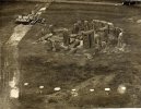
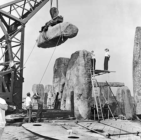
But while these details have come to light in recent years, many people are unaware that Stonehenge as we see it today was in FACT rebuilt, several times, and dozens of images prove that the standing stones we see today, in fact dates back less than 50 years.

As noted intricately by indymedia.org.uk, from 1901 to 1964, the majority of the stone circle was restored in a series of makeovers which have left it, in the words of one archaeologist, as ‘a product of the 20th-century heritage industry’.

Sadly, the truth is that the monument we see today was rebuilt as far back as 1901 when restoration process caused great outrage but was rarely referred to in official guidebooks.

William Gowland oversaw the first major restoration of the monument which involved the straightening and concrete setting of sarsen stone number 56 which was in danger of falling. In straightening the stone he moved it about half a meter from its original position.

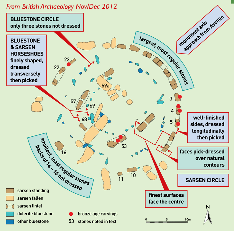
During the 1920 restoration William Hawley, who had excavated nearby Old Sarum, excavated the base of six stones and the outer ditch. Richard Atkinson, Stuart Piggott and John F. S. Stone re-excavated much of Hawley’s work in the 1940s and 1950s and discovered the carved axes and daggers on the Sarsen Stones.

In 1958 the stones were restored again when three of the standing sarsens were re-erected and set in concrete bases. The last restoration was carried out in 1963 after stone 23 of the Sarsen Circle fell over.

Cambridge University archeological archivist and leading Stonehenge author Christopher Chippindale admitted: ‘Not much of what we see at Stonehenge hasn’t been touched in some way’. And historical research student Brian Edwards, who recently revealed that the nearby Avebury Monument had been totally rebuilt, has found rare pictures of Stonehenge being restored. He said: ‘It has been as if Stonehenge had been historically cleansed’. ‘For too long people have been kept in the dark over the Stonehenge restoration work. I am astonished by how few people know about it. It is wonderful the guide book is going to tell the full story in the future.’

stonehenge_104.jpg
 
I was aware from comments made in a couple of books and papers that there had been fairly extensive work done to re-erect or shore up the stones, but these photos show a lot more than that!
 
Just some of the many changing faces of Stonehenge/Giants Dance down the centuries.

There is also the very interesting from Quintus to MT Cicero

"The temples of the Britons are raised and constructed in a circular form, with obelisks of stone, over which are imposts, all of huge dimensions untouched by the chisel; a peace offering to Geranius, or Apollo, the sun. The huge stones of which they are composed, lay scattered by the hand of nature on the plain: these, with myriads of labourers, the high priest caused to be rolled up on the inclined planes of solid earth, which had been formed by the excavation of trenches, until they had attained a height equal to their own altitude; these pits being dug, they were launched from the terrace and sunk so as to stand perpendicular, at due and equal distances in the circle, and over these were placed others horizontally. After having completed one circle, they formed another that is concentric at some distance, and towards the extremity of the area of the inner circle, they placed a huge stone for the purpose of religious rites. When the sun enters into Cancer, [mid summer] is the greatest festival of the god; and on all high mountains and eminences of the country, they light fires at the approach of that day, and make their wives, their children, and their cattle, to pass through the fire, or to present themselves before the fire in honour of the deity. Deep and profound is the silence of the multitude during this ceremony, the appearance of the sun above the horizon, when, with loud and continued exclamations, and songs of joy, they hail the utmost of that luminary, as the supreme triumph of the symbol of the god of their adoration."

Sounds like attempts to resurrect an already broken site. "The huge stones of which they are composed, lay scattered by the hand of nature on the plain'. Makes me think of the hand comets may have played in previous deconstruction...
 

Attachments

  • 1740- By William Stukeley.jpg
    1740- By William Stukeley.jpg
    124.9 KB · Views: 467
  • 1835 - stonehenge-john constable.jpg
    1835 - stonehenge-john constable.jpg
    162 KB · Views: 462
  • c.1885 - Stonehenge_with_farm_carts.jpg
    c.1885 - Stonehenge_with_farm_carts.jpg
    140.1 KB · Views: 465
  • Post WWI photo pre 1960s reconstruction.jpg
    Post WWI photo pre 1960s reconstruction.jpg
    159.8 KB · Views: 457
It makes me wonder if they stood up the stones in the right positions or if they were just making assumptions. For example, at the moment they look like they follow a pattern of concentric circles, but what if it was originally a spiral?

stonehenge-laser-plan.jpg
 
Sounds like attempts to resurrect an already broken site. "The huge stones of which they are composed, lay scattered by the hand of nature on the plain'.

as the ice retreated at the big melt it left those boulders behind in German they are called ''findling'' a erratic glacial rock
 
Back in January 2003, a bushfire raged through Canberra and took out a couple of the telescope mounts on Mount Stromlo. These mounts look for all the world like a smaller version of Stonehenge, with the round outer portion with a flat top which could hold a rotating dome, and the telescope mounts inside, protected from the weather by the dome. The Mount Stromlo mounts are quite massive, but obviously not as large as those at Stonehenge. This page has some of the photos before and after:

https://bygoneaustralia.wordpress.com/2012/01/22/mt-stromlo-observatory-canberra/
 
MusicMan said:
Back in January 2003, a bushfire raged through Canberra and took out a couple of the telescope mounts on Mount Stromlo. These mounts look for all the world like a smaller version of Stonehenge, with the round outer portion with a flat top which could hold a rotating dome, and the telescope mounts inside, protected from the weather by the dome. The Mount Stromlo mounts are quite massive, but obviously not as large as those at Stonehenge. This page has some of the photos before and after:

https://bygoneaustralia.wordpress.com/2012/01/22/mt-stromlo-observatory-canberra/

That's interesting. Indeed one wonders what Stonehenge could have been the FOUNDATION for?
 
Thinking about the roofs reminded me of the circular buildings at Chaco canyon and how they found some evidence of timbers that could be related to the roof, so i did a quick search and came across a building, Casa Rinconada, which i thought looked a bit like the Stonehenge layout. While they speculate what the roof of Rinconada could have been like, they found no traces other than what they assume to be areas where four timber supports could have been:

27173806_10159838478170425_3552328783178649103_o.jpg


and here's another example someone else put together :


26991708_10159838537160425_7620061090157143450_n.jpg


Some info on the site:

Casa Rinconada is an Ancestral Puebloan archaeological site located atop a ridge adjacent to a small rincon across from Pueblo Bonito in Chaco Culture National Historical Park, northwestern New Mexico, United States.

The Ancestral Puebloan great kiva, Casa Rinconada.

It is an isolated great kiva (out of four in Chaco Canyon) with all the typical elements of great kivas: a masonry firebox, an inner bench, four roof-supporting large seating pits, masonry vaults, and 34 niches, divided into two sizes, encircling the kiva. There is also an unusual 39 foot (12 m) long underground passage, perhaps used in the ceremonies to allow performers sudden entry thus surprising the audience. It was dug out of the sandstone and shale that compose the ridge on which the kiva sits.

Casa Rinconada was excavated in 1930-31 by archaeologists Vivian and Reiter and the University of New Mexico/School of American Research field schools. It was reconstructed in part by Vivian in 1933, while Richter of the National Park Service worked on capping outer walls in 1955.

Casa Rinconada is accessible through the Canyon Loop Drive and 1/2-mile (800 m) trail (round trip) off the Drive.

With a diameter of 64 feet (20 m), Casa Rinconada is the largest great kiva in Chaco Canyon.[2]
800px-Casa_Rinconada.jpg

748px-Casa_Rinconada_II.png

Which looks a little like a picture from the link Music man posted:

p1070981.jpg


and on the Kiva's:
Great kiva

Evolution

During the late eighth century, Mesa Verdeans started building square pit structures that archeologists call protokivas. They were typically 3 or 4 feet (0.91 or 1.22 m) deep and 12 to 20 feet (3.7 to 6.1 m) in diameter. By the mid-10th and early 11th centuries, these had evolved into smaller circular structures called kivas, which were usually 12 to 15 feet (3.7 to 4.6 m) across. Mesa Verde-style kivas included a feature from earlier times called a sipapu, which is a hole dug in the north of the chamber that is thought to represent the Ancestral Puebloan's place of emergence from the underworld.[3][4]

When designating an ancient room as a kiva, archaeologists make assumptions about the room's original functions and how those functions may be similar to or differ from kivas used in modern practice. The kachina belief system appears to have emerged in the Southwest around AD 1250, while kiva-like structures occurred much earlier. This suggests that the room's older functions may have been changed or adapted to suit the new religious practice.

As cultural changes occurred, particularly during the Pueblo III period between 1150 and 1300 AD, kivas continued to have a prominent place in the community. However, some kivas were built above ground. Kiva architecture became more elaborate, with tower kivas and great kivas incorporating specialized floor features. For example, kivas found in Mesa Verde were generally keyhole-shaped. In most larger communities, it was normal to find one kiva for each five or six rooms. Kiva destruction, primarily by burning, has been seen as a strong archaeological indicator of conflict and warfare among people of the Southwest during this period.

Fifteen top rooms encircle the central chamber of the vast Great Kiva at Aztec Ruins National Monument. The room's

"...purpose is unclear.... Each had an exterior doorway to the plaza.... Four massive pillars of alternating masonry and horizontal poles held up the ceiling beams, which in turn supported an estimated 95-ton roof. Each pillar rested on four shaped-stone disks, weighing about 355 pounds [161 kg] apiece. These discs are of limestone, which came from mountains at least 40 miles away."[5]

After 1325 or 1350, except in the Hopi and Pueblo region, the ratio changed from 60 to 90 rooms for each kiva. This may indicate a religious or organizational change within the society, perhaps affecting the status and number of clans among the Pueblo people.

Great kiva

Great kivas differ from regular kivas, which archeologists call Chaco-style kivas, in several ways; first and foremost, great kivas are always much larger and deeper than Chaco-style kivas. Whereas the walls of great kivas always extend above the surrounding landscape, the walls of Chaco-style kivas do not, but are instead flush with the surrounding landscape. Chaco-style kivas are often found incorporated into the central room blocks of great houses, but great kivas are always separate from core structures. Great kivas almost always have a bench that encircles the inner space, but this feature is not found in Chaco-style kivas. Great kivas also tend to include floor vaults, which might have served as foot drums for ceremonial dancers, but Chaco-style kivas do not.[6] Great kivas are believed to be the first public buildings constructed in the Mesa Verde region.[7]

And its some info on the possible alignments:


http://what-when-how.com/ancient-astronomy/casa-rinconada/ said:
Casa Rinconada was the largest of the great kivas in Chaco Canyon. Kivas were subterranean circular buildings used as meeting places or for sacred ceremonies. In Chaco they were generally built with their roofs at ground level, within the central plazas of Great Houses such as Pueblo Bonito, where over thirty-five examples, great and small, are to be found. Casa Rin-conada was unlike the other kivas in both these respects. It was built on its own, separately from any Great House, and while the dirt floor was 3.5 meters (twelve feet) below the surrounding ground level, its walls protruded above the ground. It measured twenty meters (sixty-six feet) across, and its vast roof (of which no trace remains) was supported by four vertical timber uprights placed near the center. There were entrances to the north and south, and around the outer wall were twenty-eight regularly spaced niches together with six larger, irregularly spaced ones.

During the 1970s, archaeoastronomers were apt to scrutinize ancient monuments anywhere in the world for potential solar and lunar alignments reflecting those that had been so famously proposed a decade earlier at Stonehenge in England; Casa Rinconada was analyzed closely in this regard. However, as these early investigators had to admit, the roof was a problem. Only through what seems to have been a single window in the north-northeast could sunlight (or moonlight) actually have entered the kiva, and the best they could come up with was that after sunrise at the summer solstice, a beam of sunlight entering through this window could have illuminated one of six niches that, for some unfathomable reason, were built slightly larger than the rest. However, the window in question has been reconstructed and its original position is uncertain, and even if it is in the original position, it seems that one of the four roof supports may have been in the way. All of this serves to illustrate the dangers of naive “alignment hunting.”

Casa Rinconada and its situation in Chaco Canyon, looking toward Pueblo Bonito on the other side of the valley


It also obscures a more fundamental property of the orientation of Casa Rinconada. The kiva was cardinally aligned: its main axis (through the entrances) was due north-south, and it was also broadly symmetrical about the east-west axis. The intention, surely, was cosmological. Creation myths that have come down to modern indigenous peoples in the vicinity tell how the first kiva was circular to reflect the circle of the sky, and conceptual principles that result in a quartering of space in relation to the cardinal directions are commonplace among indigenous North American groups to this day. As archaeoastronomer Ray Williamson concluded back in 1982, Casa Rin-conada “was meant to serve as an earthly image of the celestial realm; … it was not an observatory, but a ritual building whose structure reflects the central place astronomy had in ancient Pueblo religious practice” (Aveni 1982, p. 205).

It is even more intriguing that principles of cardinality seem to have extended into the landscape. In 1978, archaeologist John Fritz drew attention to the fact that three major Chaco structures, the Great House of Pueblo Alto to the north of the canyon, Casa Rinconada within it, and Tsin Kletzin, another Great House on the mesa to the south, lie on a north-south line. This, argued Fritz, was the main axis of the city. The two largest Chacoan buildings, Chetro Ketl and Pueblo Bonito, lie on either side of this axis, almost equidistant from it, and on an east-west line. Fritz’s contention was that these two cardinal axes were of fundamental importance in the minds of the Cha-coans, a theory that received a dramatic endorsement with the subsequent discovery of what has become known as the (Great) North Road, which extends the north-south axis physically northwards for at least fifty-five kilometers. Archaeologist Steve Lekson has extended this idea still further, arguing the existence of a “Chaco Meridian” that extended from Aztec, over eighty kilometers (fifty miles) north of Chaco, right down to Paquime in modern Mexico, a staggering 630 kilometers (390 miles) to the south.

An investigation in the 1980s of the orientations of the principal walls of Chacoan Great Houses showed that only four out of fourteen of them were aligned cardinally. However, three of the four lie on Fritz’s axes: Pueblo Bonito (north-south) and Pueblo Alto and Tsin Kletzin (both east-west). Casa Rinconada itself was also cardinally aligned, as we have already seen. Only Chetro Ketl stands out as an exception, its principal wall oriented at an azimuth of about seventy degrees. The fact that all but one of the buildings situated on the cardinal axes were themselves cardinally aligned surely adds strength to the idea that the cardinal directions and Fritz’s axes were of fundamental importance. (Conversely, all but one of the buildings not lying on these axes were not cardinally aligned.)

During its first half-century of existence, archaeoastronomy has matured considerably as a discipline, moving on from “alignment hunting” to addressing culturally relevant questions. In the same period, Casa Rin-conada has been transformed from a building containing numerous potential solar and lunar alignments (an idea that never really resonated with the cultural evidence) to a central point within an astronomically referenced sacred landscape.
 
Another possible comparison would be the structures at Gobekli Tepe:

https://en.wikipedia.org/wiki/G%C3%B6bekli_Tepe

http://gobeklitepe.info/

http://www.ancient-origins.net/news-history-archaeology/archaeologists-find-12000-year-old-pictograph-gobeklitepe-003441
 
See here: http://maajournal.com/Issues/2017/Vol17-1/Sweatman%20and%20Tsikritsis%2017%281%29.pdf

An extremely interesting interpretation of Gobekli Tepe

Abstract of the paper:

We have interpreted much of the symbolism of Göbekli Tepe in terms of astronomical events. By matching low - relief carvings on some of the pillars at Göbekli Tepe to star asterisms we find compelling evidence that the famous ‘Vulture Stone’ is a date stamp for 10950 BC ± 250 yrs, which corresponds closely to the proposed Younger Dryas event, estimated at 10890 BC . We also find evidence that a key function of Göbekli Tepe was to observe meteor showers and record cometary encounters. Indeed, the people of Göbekli Tepe appear to have had a special interest in the Taurid meteor stream, the same meteor stream that is proposed as responsible for the Younger - Dryas event. Is Göbekli Tepe the ‘smoking gun’ for the Younger - Dryas cometary encounter, and hence for coherent catastrophism?
 
Taurid :huh:

Does that mean from The constellation of Taurus?

Again, this reminds me of Perseus slaying the bull as presented in many temples of Mithra-ism. Slaying bull's throat with knife aka sword; comets were pictured as swords on ancient paintings... Maybe The Comet [Cluster] will shoot through Taurus Constellation on its lethal mission?

FWIW :-[
 
Yozilla said:
Taurid :huh:

Does that mean from The constellation of Taurus?

From the Taurids wiki:

They are named after their radiant point in the constellation Taurus, where they are seen to come from in the sky. Because of their occurrence in late October and early November, they are also called Halloween fireballs.
 
rrraven said:
Sounds like attempts to resurrect an already broken site. "The huge stones of which they are composed, lay scattered by the hand of nature on the plain'.

as the ice retreated at the big melt it left those boulders behind in German they are called ''findling'' a erratic glacial rock

I guess all things are possible. Here's another take on the origin of the stones of Stonehenge:

https://news.nationalgeographic.com/news/2011/12/111222-stonehenge-bluestones-wales-match-glacier-ixer-ancient-science/
 
This could be related:

Ancient Arkaim: The Stonehenge of Russia
http://www.ancient-origins.net/ancient-places-asia/older-stonehenge-arkaim-russia-00251

There are a few suggestions that the site has a similar structure as Troy (as described in the Iliad of Homer).

ArkaimPlan.jpg


Arkaim.jpg


More info:

http://www.ancient-wisdom.com/russiaarkaim.htm
http://perm-asha.chat.ru/arkaim_e.html
http://eng.gubernator74.ru/chelyabinsk-region/brands/arkaim
http://www.newdawnmagazine.com/articles/arkaim-russias-ancient-city-the-arctic-origin-of-civilisation
http://www.crystalinks.com/arkaim.html

arkaim_mabdala2.jpg


http://www.crystalinks.com/arkaim.html

The fire that eliminated the 'living' history of Arkaim is among the most intriguing riddles of this ancient structure. It would be less strange if it was one of those natural disasters that even today, quite often, suddenly destroy whole settlements, taking inhabitants off-guard and burying belongings, along with anyone who couldnÕt escape...

Comparisons of Arkaim with Stonehenge are not accidental. Careful research of Arkaim by archeologists and astronomers has determined that it is a celestial observatory of ultimate accuracy. Modern astronomers have been surprised by the fact that a project of such versatility, complexity and accuracy has been fulfilled, the more that no traces of earlier and simpler constructions were found.

Notable in the collection of confirmed patterns is the use of the Golden Section rule in the internal circle, consisting of 27 walls and 12-sectioned zodiac partitionings.

The internal circle has been devoted to the Sun, the external one to the Moon. The inclination of lunar orbit to the ecliptic plane (5¼ 09 ') is defined very precisely.

In the erection of the ring-shaped internal wall they used a circle with a radius measuring 52.65 of ArkaimÕs linear measures (one Arkaim linear measure equals 80.0 cm) that corresponds to 52° 39' the latitude of Arkaim. The latitude of Arkaim, by the way, is close to the latitude of Altai barrow Arjan (52° 00 ') and Stonehenge (51° 17'), and it is possible that this strip on the EarthÕs surface, as well as the 30th parallel, had significant meaning for ancient astronomers and priests.

Measurements confirmed that the ancients of the Southern Ural were aware of the phenomenon of the precision of the EarthÕs axis expressed in ratios of the internal circle. The period of this phenomenon is enormous - 25,786 years, but ArkaimÕs builders portrayed corresponding parameters perfectly and very precisely. Researchers specifically note that in order to create this sort of observatory they had to know that the Earth has the form of a sphere and together with other planets spins around the Sun... (On ArkaimÕs ceramic ware, the sacred sign for the Òsun wheelÓ, a swastika was found.) Another surprise is that the city itself, and mortuary facilities in its plan, represent the combination of a circle and a square.

On our planet, quite a few archeological finds confound modern science: the Egyptian and Mayan pyramids, the great figures of the Nasca desert, Stonehenge in England, Zorats-Kar in Armenia and, it seems, our Arkaim.
 

Attachments

  • arkaim_mabdala1.jpg
    arkaim_mabdala1.jpg
    41.4 KB · Views: 21
  • arkaim_mabdala2.jpg
    arkaim_mabdala2.jpg
    52.3 KB · Views: 24
Back
Top Bottom