The following was posted in the Strange Sounds in the Sky thread:
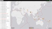
MK Scarlett said:And I've just saw (on FB) this 'line' made by earthquakes on the same hour:
Definitevely interesting times!