Storm Gerrit in Scotland
You are using an out of date browser. It may not display this or other websites correctly.
You should upgrade or use an alternative browser.
You should upgrade or use an alternative browser.
Crazy Storm Weather and Lightning - Global
- Thread starter mabar
- Start date
It's really getting crazy. A tornado hits Manchester, hurricane force winds in Siberia and a big hail storm in Argentina are the latest events. All while the stratosphere is colder than usual, stratospheric clouds appear early.
Violent #hail storms and strong winds have caused damage in cities in the provinces of #LaPampa and West of #BuenosAires #Argentina
Strong winds complicate traffic on the Omsk highway of Siberia, #Russia (December 27, 2023). #Extreme #Winds #Ice #Snowstorm #Climagram
The central west coast experiences its first wave of storm fronts with 25ft breaks causing havoc and evacuations.
 abc7news.com
Bay City News Thursday, December 28, 2023, 8:45 PM
abc7news.com
Bay City News Thursday, December 28, 2023, 8:45 PM
Current Participation on the West Coast

Current Wave Heights

Live Updates: Flooding and evacuations along NorCal coastline with dangerous waves
An evacuation order has been issued in parts of Marin County and a warning has been issued in parts of Santa Cruz County due to flooding with the high surf. Here's the latest.
SAN FRANCISCO -- Flooding and evacuation warnings are being put into effect around Northern California as dangerous waves hit the coastline Thursday morning.
The National Weather Service earlier issued a Coastal Flood Advisory for the Coastal North Bay through 3 a.m. Friday.
The NWS also issued a High Surf Warning for the Central and Northern California coastline that is in effect until 3 a.m. Friday.
Stinson Beach Evacuation and Flooding
Marin County residents have been ordered to evacuate Thursday due to possible flooding at Stinson Beach after forecasters said there will be severe weather conditions in North Bay areas.
Stinson Beach Fire issued the evacuation order for the areas of Calles Pinos, Pradero, Sierra, Onda Resaca, Ribera, and Embarcadero, as well as sections of Calle Del Arroyo.
The Marin County Sheriff's Office advised community members to stay alert as high surf and storm surges might flood and damage structures at Stinson Beach.
Residents were urged not to wade or drive through flooded areas.
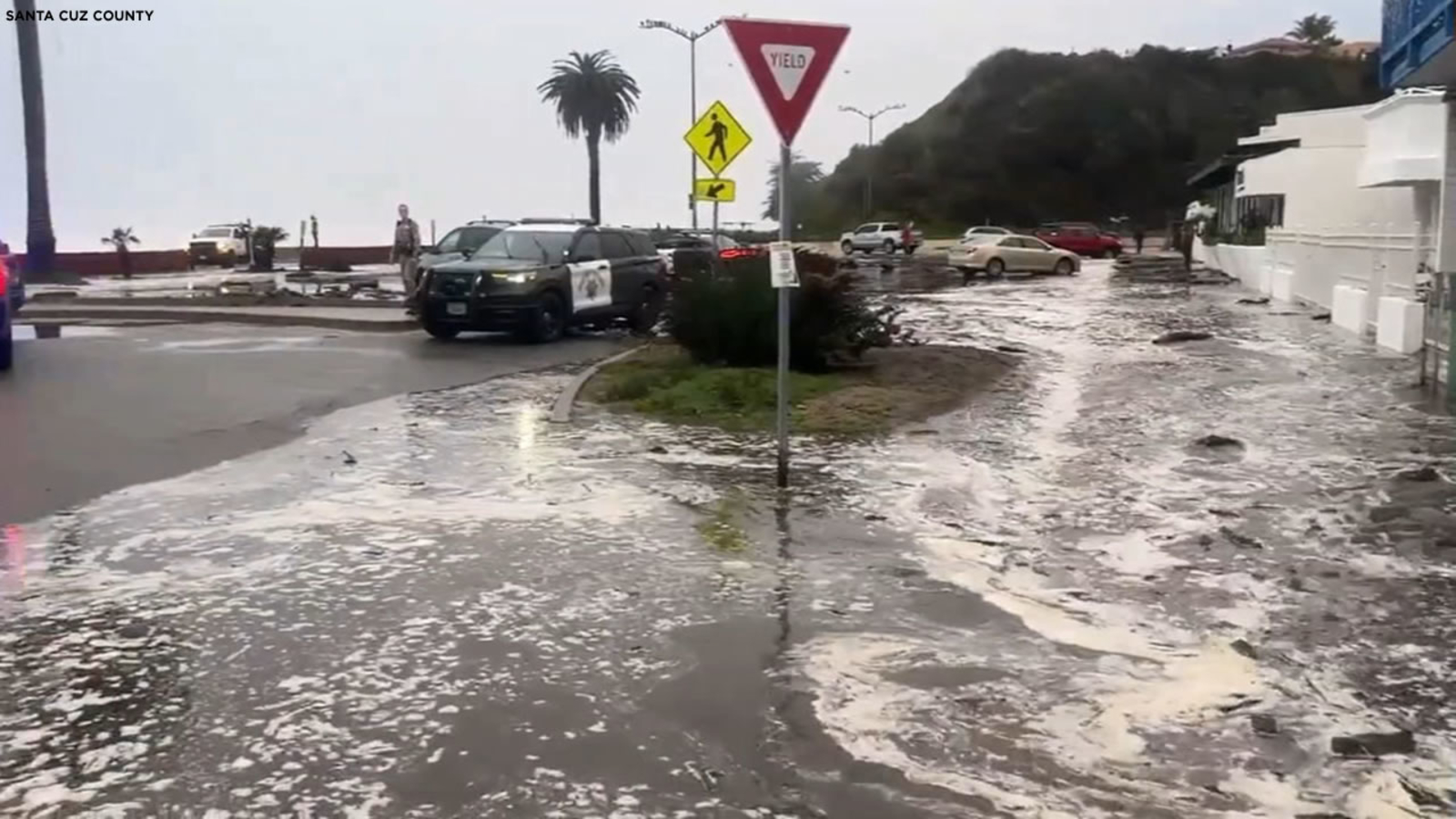
Santa Cruz County Evacuation and Flooding
An evacuation warning has been issued for a coastal area of Santa Cruz County near Seacliff State Beach on Thursday morning, county officials said.
The evacuation warning was issued for zone CTL-E048 because of large breaking waves and high tides causing safety threats along the coast.
Santa Cruz County has also extended the evacuation warning to the Pajaro Dunes area.
Residents can see if their zone is under a warning or evacuation order here.
Santa Cruz County officials earlier Thursday advised residents to avoid various coastal areas, saying there is flooding along East Cliff Drive as well as the Rio Del Mar Esplanade.
A big log also has blocked the roadway at Moran Lake, according to the California Highway Patrol.
ABC7 News contributed to this story.
This story will be updated with new information as it is available.
Current Participation on the West Coast
Current Wave Heights
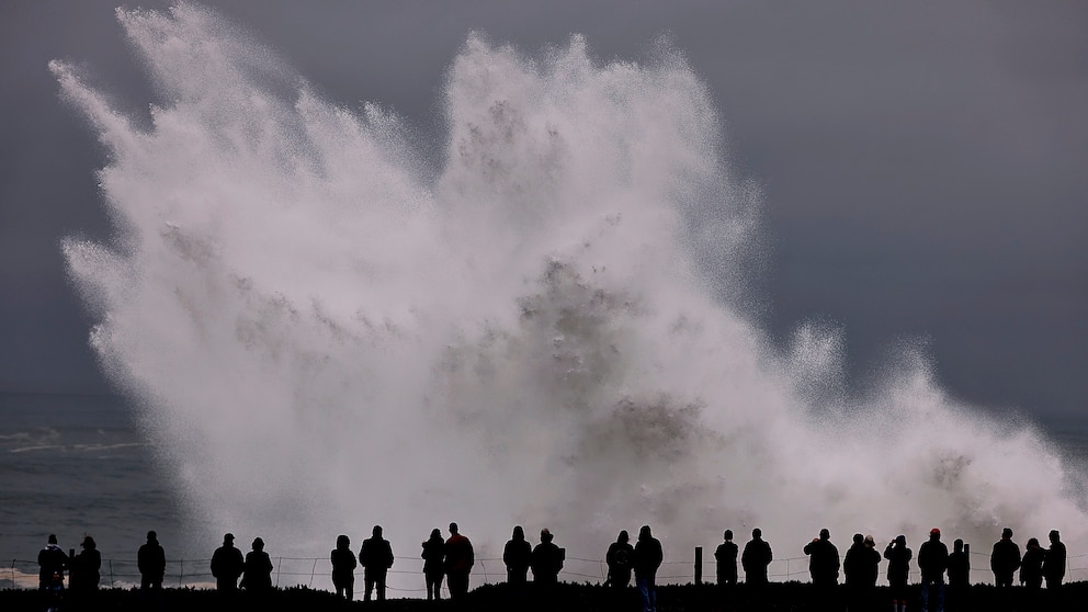
Strong waves pound California coast, injuring at least 8
One wave sent eight people to the hospital, Ventura County official said.As a crowd watched the high surf at the end of an avenue in Ventura, California, a "rogue" wave crashed over the seawall, flooding the area and carrying people and vehicles up the street.
The wave sent eight people to the hospital on Thursday, a spokesperson for the Ventura County Fire Department said on social media.
Cities along the California coast were warning residents that the rough waters caused by a Pacific storm this week can turn quickly into dangerous waves.
"Stay away from rocks, jetties, piers, and other waterside infrastructure," the National Weather Service in the Bay Area said on social media. "Never turn your back to the ocean!"
The highest surf was expected Thursday, but conditions were still forecast as dangerous and were expected to continue into Saturday. A high surf warning remained in place for Southern California into Saturday night with waves 15 to 20 feet, and local sets reaching 25 feet.
The rain is forecast to start Friday morning in the northwest and is expected to reach the Bay Area by the afternoon. It could impact evening travel around San Francisco. The storm also comes with wind, especially near the coast, where gusts could reach 50 mph Friday.
Strong waves pound California coast, injuring at least 8
Cities along the California coast were warning residents that the rough waters caused by a Pacific storm this week can turn quickly into dangerous waves.
This is what conditions were like yesterday on the beach in Ventura, California.
Large waves pounded the Southern California coastline on Thursday, causing flooding in coastal communities and multiple rescues by lifeguards. #HighSurf
Strong waves pound California coast, injuring at least 8
Watch out for strong winds in the northwest this evening and night. Start around 8 p.m. in Finistère. More info at https://meteo-express.com/article/coup-d

Superb satellite image showing the arrival of depression #Geraldine near Ireland on December 30. The associated cold front will approach #Bretagne this evening, accompanied by powerful gusts of #vent .Image: NASA - Worldview

Eurostar trains canceled: Pumping of water leak in Channel Tunnel has started
After the cancellation of many Eurostar trains in the morning, the railway company has finally decided to cancel all its trains to or from London for the day of Saturday December 30. Severe traffic disruption has been recorded due to flooding of tracks in the south of England, stranding thousands of passengers on one of the busiest weekends of the year.
In total, 41 trains were canceled. This represents around 30,000 passengers, who find themselves stranded in London, Paris, Brussels or Amsterdam.
“Due to an infrastructure problem on the high-speed line near London, we are forced to cancel certain trains departing from or destined for London ,” the railway company explained this morning on its site. “Due to flooding of a tunnel on the high-speed line near London, we have to cancel all our trains on our line to/from London on Saturday December 30 ,” Eurostar added a few hours later.
Flooding has occurred in both rail tunnels near Ebbsfleet International, meaning both tunnels are closed and no trains can run between Saint Pancras International, the Eurostar departure and arrival station in London , and Ebbsfleet International. These floods on the tracks affect, in addition to Eurostar traffic, train traffic linking London and the south-east of England.
Exchange of reservations
Heavy rain is still expected in this part of England on Saturday. The Eurostar company offers passengers the option to exchange their reservation for a trip at a later date or to cancel their ticket.
On December 21, in the middle of the holiday departure period, Eurostar passengers were already faced with numerous train cancellations due to a surprise strike which paralyzed the Channel Tunnel. A total of 30 trains were canceled that day, leaving thousands of travelers without a solution. Some then turned to the bus or the plane at the last moment, in the hope of reaching their loved ones in time for Christmas.
Last edited:
National Centers for Environmental Prediction
Following from my previous update a few days ago modelling has become far more uncertain on whether the UK will see deeper cold moving south following a retrogressing high. What do we know?
Below avg temps out to the 15th
Wintry showers in places but mostly dry
High moves NW towards mid month
? Cold air moves south
Beyond those basics, the detail remains messy.
Modelling with the Pacific high is causing the issues, the Pacific high drains the heights away from Greenland on some runs which then allows the jet to nudge further north. The jet stream is very south shifted and not all that strong or interested in pushing back northwards.
Modelling with the Pacific high is causing the issues, the Pacific high drains the heights away from Greenland on some runs which then allows the jet to nudge further north. The jet stream is very south shifted and not all that strong or interested in pushing back northwards.
One thing to note is that modelling is absolutely all over the place in terms of the Pacific and there's still time for things to trend back the other way, background forcing remains favourable for HLB on our side of the Atlantic, we have a weak Atlantic and a weak polar vortex.
Westerly momentum overall remains fairly high following recent strong +MT events albeit it has fallen off a little and the MJO remains stalled in a slow moving phase 3. All in all, from a background forcing point of view blocking is favoured & to be fair, blocking is what we're going to be seeing/are seeing currently, today. Cold air is filtering in across the UK today.
The only issue is whether the UK, a tiny island can tap into some much colder air or not. The teleconnections have done their job re: the broadscale pattern and have produced blocked patterns, that just doesn't automatically = UK cold unfortunately, we need a little luck on the regional/smaller scale for that.
UK LIKELIHOODS:
Colder weather at least at the surface will be with us for a while, below average and frosty where skies are clear. Potential for snow still higher towards the middle of January but exact details have become muddy and more uncertain.
Previous 3 updates in the reply to this.
Less than a few miles from the coast

Atlantic Canada prepares for arrival of 1st winter storm of 2024
Das Video

As the current climate (scam) narrative falls apart, MSN manipulates its audience with the fear of droughts.
Météo Pyrénées
Baqueira of the notable accumulations! @sandraruro22
Winter Storms in the Northeast, the Western U.S., and Portions of Alaska
252 AM EST Sun Jan 07 2024 Snip:A winter storm continues to produce heavy snow, strong winds and minor coastal flooding in the Northeast. The Pacific storm is producing coastal rain, high elevation snow and strong winds along the West Coast into the Intermountain West to the Southwest and the Rockies. An Alaskan storm will impact southwest Alaska and the Arctic coast. Read More >
Snip:
Short-Range Forecast Discussion
NWS Weather Prediction Center College Park MD
252 AM EST Sun Jan 07 2024
Valid 12Z Sun Jan 07 2024 - 12Z Tue Jan 09 2024
...Major winter storm will produce additional heavy snow for Northeast and
Central Appalachians today...
...Rapidly strengthening storm will lead to widespread, significant
impacts over much of the central U.S. beginning Monday...
...Major winter storm will dump several feet of snow over the Washington
and Oregon Cascades
There are three storm systems that are and/or will be impacting the CONUS
over the next few days. The first of the three is the major winter storm
bringing heavy snow and strong winds to the Northeast and Central
Appalachians today. Additional snowfall of 4-8 inches are expected for
much of the aforementioned areas through tonight when the storm is
expected to pull away into the Atlantic. Winter Storm Warnings and Winter
Weather Advisories are in effect. Conditions should improve on Monday.
Following from my previous update a few days ago modelling has become far more uncertain on whether the UK will see deeper cold moving south following a retrogressing high. What do we know?
Below avg temps out to the 15th
Wintry showers in places but mostly dry
High moves NW towards mid month
? Cold air moves south
Beyond those basics, the detail remains messy.
Modelling with the Pacific high is causing the issues, the Pacific high drains the heights away from Greenland on some runs which then allows the jet to nudge further north. The jet stream is very south shifted and not all that strong or interested in pushing back northwards.
Modelling with the Pacific high is causing the issues, the Pacific high drains the heights away from Greenland on some runs which then allows the jet to nudge further north. The jet stream is very south shifted and not all that strong or interested in pushing back northwards.
One thing to note is that modelling is absolutely all over the place in terms of the Pacific and there's still time for things to trend back the other way, background forcing remains favourable for HLB on our side of the Atlantic, we have a weak Atlantic and a weak polar vortex.
Westerly momentum overall remains fairly high following recent strong +MT events albeit it has fallen off a little and the MJO remains stalled in a slow moving phase 3. All in all, from a background forcing point of view blocking is favoured & to be fair, blocking is what we're going to be seeing/are seeing currently, today. Cold air is filtering in across the UK today.
The only issue is whether the UK, a tiny island can tap into some much colder air or not. The teleconnections have done their job re: the broadscale pattern and have produced blocked patterns, that just doesn't automatically = UK cold unfortunately, we need a little luck on the regional/smaller scale for that.
UK LIKELIHOODS:
Colder weather at least at the surface will be with us for a while, below average and frosty where skies are clear. Potential for snow still higher towards the middle of January but exact details have become muddy and more uncertain.
Previous 3 updates in the reply to this.
Less than a few miles from the coast
Atlantic Canada prepares for arrival of 1st winter storm of 2024
Das Video
As the current climate (scam) narrative falls apart, MSN manipulates its audience with the fear of droughts.
Météo Pyrénées
Baqueira of the notable accumulations! @sandraruro22
Washington and Oregon State get battered by fierce winds and snow.


 www.seattletimes.com
A winter storm will produce heavy snow, blizzard conditions, & snow squalls across portions of the West through Thursday. By Thursday night, the storm system will track towards the Midwest where it will bring another round of impactful wintry weather & strong winds late week.10:00 PM · Jan 9, 2024

First the wind, then the chill — and snow in the Seattle area?
In the Cascades, "an incredible amount of snow" was forecast to fall, thanks to the system that has pushed eastward, the weather service said.
www.seattletimes.com
NWS Weather Prediction CenterSwish, swoosh. Whoooosh, whiff. Plop, plunk, pitter-patter, pitter-patter, pitter-patter!
If you didn’t hear the sighing, howling, wailing, rustling or shrieking of the wind overnight, you’ll get another opportunity on Tuesday.
Mother Nature is continuing to check off a laundry list of winter weather conditions — including strong winds and heavy mountain snow — that are “on the wild side, even for Western Washington,” the National Weather Service said.
The system responsible for the 14 weather service watches, warnings and advisories currently in effect across Western Washington slammed into the coast Monday evening, spreading inland overnight.
Southerly winds increased with the arrival of this overnight weather-maker, gusting up to 50 mph and leaving tens of thousands without power in the Seattle area.
As of 6:45 a.m., 416 outages have left 23,274 Puget Sound Energy customers without power.
Shortly after midnight on Tuesday, 6,350 Seattle City Light customers were without power. As of 6:45 a.m., 2,671 customers remain without power.
Wind gusts up 50 mph remain in the forecast through the lowlands on Tuesday where a wind advisory is in place through 10 p.m., the weather service said.
Wind speeds and gusts will vary by location on Tuesday. The strongest winds will begin blowing late Tuesday morning, peaking in the afternoon when gusts up to 55 to 65 mph are possible through the Strait of Juan de Fuca.
Areas in and around the strait are included in a high wind warning in effect through Tuesday afternoon.
Winds are expected to ease by nightfall.
Meanwhile, in the mountains, “an incredible amount of snow” is expected to fall through Wednesday thanks to the system that has pushed eastward, the weather service said.
Webcams at Snoqualmie and Stevens passes showed near-whiteout conditions around 4 a.m. Tuesday, which was shortly after the winter storm warning converted to a blizzard warning an hour earlier than expected. (Snoqualmie Pass traffic cameras were down later that morning because of a power outage.)
On Tuesday, winds gusting as high as 65 mph and an additional 2 to 3 feet of snow above 2,000 feet will create periods of whiteout and near-zero visibility, according to the weather service.
The Washington State Department of Transportation and Washington Emergency Management are urging drivers to avoid traveling through the passes.
Blizzard warnings are rare in Western Washington — the last one was in 2012 — and they require a combination of blowing snow, 35+ mph winds and quarter-mile visibility for three hours or more, according to the weather service.
Continuing our tour of current weather hazards across Western Washington, we arrive at the coast, where another cycle of king tides is expected. Low pressure, strong onshore winds and large swells (up to 28 feet with large breaking waves of 15 to 30 feet) will increase the risk of coastal flooding on Tuesday, the weather service said.
Significant coastal flooding is forecast on the coast and around the San Juan Islands on Tuesday. There is a coastal flood warning in effect through the afternoon for inundation up to 3 feet above ground level.
As we move into Thursday, meteorologists are tracking a rush of cold Canadian air bearing down on the region from the north, but “much, much uncertainty must be expressed in the evolution of the long term forecast,” the weather service said.
However, confidence is rising that temperatures will fall well below average heading into the weekend — overnight lows sinking below freezing are possible, while highs will struggle to crest 32 degrees.
Now, how much moisture will be around?
“That is the million-dollar question,” the weather service said.
As of Tuesday morning, there is a 40% to 60% chance of 2 inches or more of snowfall for much of the lowlands, including Seattle, starting Friday.
There is a 30% to 40% chance that snowfall could exceed 4 inches across most of the lowlands.
Stay tuned!

A winter storm will produce heavy snow, blizzard conditions, & snow squalls across portions of the West through Thursday. By Thursday night, the storm system will track towards the Midwest where it will bring another round of impactful wintry weather & strong winds late week.10:00 PM · Jan 9, 2024
The #cycloneBelal is about to hit The #Réunion . Its latest trajectory forecast takes it to cross the island from north to south. #vents at 200 km/h, waves of 8 to 12 m and accumulations of #pluies up to 1000 mm are envisaged. It could be one of the most powerful cyclones to hit the island since #Firinga in January 1989 and #Jenny in February 1962.
Belal is there Don't forget rent zot caz afterwards Reunion - Barachoix
The birds are also waiting patiently for Belal. They gathered at the Barachois bar trucks. It's borderline creepy, don't you think?
Line-2
To the Barachois! RB photos - MB videos - Imaz Press #CycloneBelal
 fr.wikipedia.org
Belal is there Don't forget rent zot caz afterwards Reunion - Barachoix
The birds are also waiting patiently for Belal. They gathered at the Barachois bar trucks. It's borderline creepy, don't you think?
Line-2
To the Barachois! RB photos - MB videos - Imaz Press #CycloneBelal
Saint-Gilles les Hauts — Wikipédia
European windstoms, historic windstorms, summary of 2023-2024 windstorm season (so far), low pressure records, cyclogenesis and explosive cyclogenesis
A gale is forecast in the northwest, with a peak during the night from Sunday to Monday between Brittany & Belgium. We expect 80-90 km/h inland and 90-110 km/h on the coasts.
Holly Wizaid of OZ
Buddy James: The Sounds of Light | Thunderbolts
Jan 14, 2024
Andrew Hall: Lightning and its Fractal Domain | Thunderbolts
Jan 7, 2024
Holly Wizaid of OZ
Buddy James: The Sounds of Light | Thunderbolts
Light makes different sounds that are dynamic, gorgeous, and mimic living creatures and other sounds of nature.
When most people think about light it's what our eyes can see, visible light—the single octave from red-to-violet light in the electromagnetic spectrum—although, in the scientific lexicon "light" is defined as the EM spectrum in its entirety.
There are frequencies we can hear and see—but the frequencies we cannot hear and see are known as radio, micro, infrared, ultraviolet, x-ray, and gamma rays.
First documented in 1882, British telephone operators described whistling and crackling sounds. It wasn't until the early 1930s that we began to associate these sounds with the Northern lights. Finally, in 2012 the first audio recording of an Aurora was released.
Interdisciplinary Geometer Buddy James dissects sounds in creation mythology, how Alfvén Waves can support wave-like variations in magnetic fields, and the non-biological ambient sound of Auroras.
Ideas and/or concepts presented in this program do not necessarily express or represent the Electric Universe model or the views of The Thunderbolts Project or T-Bolts Group Inc. you see a CC with this video, it means that subtitles are available.
To find out which ones, click on the Gear Icon in the lower right area of the video box and click on “subtitles” in the drop-down box. Then click on the subtitle that you would like. YouTube also offers auto-translation in over 80 languages.
Andrew Hall: Lightning and its Fractal Domain | Thunderbolts
Lightning is an electrical discharge primarily observed as vertical cloud-to-ground lightning strikes—but electrical discharges also occur cloud-to-cloud or ground-to-ground, and sometimes with different return paths in the circuit.
Landforms can be identified with an understanding of energy, frequency and vibration. In a holographic Electric Universe, everything is an interference pattern, including matter—it’s just potential energy stored in a standing wave.
Author and engineer Andrew Hall dissects radial electrical discharge from the sphere of the planet which produces coaxial discharge circuits—where both the discharge and return path share the same space—and shows evidence of electromagnetic effects that leave undeniable geometric patterns found all over the Earth.

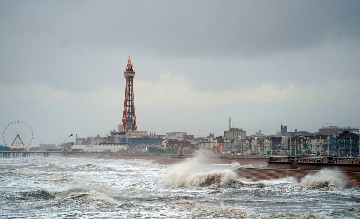
Storm Isha forces UK flights to divert to France and Germany
Several UK planes are redirected to French and German airports due to Storm Isha.
www.bbc.com
Storm Isha forces UK flights to divert to France and Germany
Storm Isha has forced a number of UK and Ireland flights to divert to France and Germany, with passengers finding themselves stranded in airports abroad.
Planes headed for Bristol, Dublin and London ended up in Paris, as several Edinburgh-bound planes landed in Cologne.
Some on domestic routes had left their passports at home, meaning they had to sleep on terminal floors overnight.
Parts of the UK have seen their strongest winds in 10 to 20 years.
....
Other diverted planes include Ryanair flights from Tenerife and Seville headed for Edinburgh which ended up in Germany's Cologne Bonn Airport.
Another Ryanair flight from Manchester to Dublin was diverted to Paris Beauvais Airport.

Storm Isha: Pensioner killed by fallen tree as Storm Jocelyn to strike next
Rare red warning issued by Met Office as Storm Isha brings ‘danger to life’
 www.independent.co.uk
Storm Isha live: Pensioner killed in crash with fallen tree as Storm Jocelyn to strike next after 107mph winds
Rare red warning issued by Met Office as Storm Isha brings ‘danger to life’
Three people have been killed in road collisions during Storm Isha as it strikes the United Kingdom.
It came as the next storm of the season, named Storm Jocelyn, is forecast to bring strong winds and heavy rain to the UK on Tuesday and into Wednesday.
Isha has wreaked havoc as flights and trains are cancelled and “danger to life” warnings remain in place with a risk of possible tornadoes.
Transport Scotland said a gust of 107mph was recorded on the Tay Bridge and the Met Office said there was one of 84mph at Salsburgh, North Lanarkshire.
Scotland’s railway operator cancelled all of its rush-hour trains and services may not begin running until later on Monday. Network Rail also stopped all freight and passengers services until the morning.
There were hundreds of cancellations at UK airports, and dozens of diversions of incoming planes – with Ryanair passengers on what is normally a half-hour hop from Manchester to Dublin ending up in Beauvais in northern France. An easyJet domestic flight from Edinburgh to Bristol diverted to Paris.
Pacific NW Weather: Atmospheric River Update
Weekend storm will bring the next round of snow to the Northeast
It may be hard to believe later this week when the temperature is pushing 60, but accumulating snow and ice can return to a portion of the Great Lakes and Northeast later this weekend, says AccuWeather meteorologists.
By Bill Deger, AccuWeather senior meteorologist Published Jan 24, 2024 6:53 AM HST Updated Jan 24, 2024 10:54 AM HST
Snip:
Following waves of rain and a surge of springlike warmth, parts of the Northeast may have to reach for the snow gear again beginning late this weekend as a new, colder storm moves in, warn AccuWeather meteorologists.
The storm, which will be the last in a series that will soak the South with over a foot of rain, will first move through the Ohio Valley and southern Appalachians to start the weekend on Saturday. After that, it will arrive with chillier air over the Northeast on Sunday, but the opportunity for wintry weather will not be equal from the Great Lakes to the Atlantic coast, like during the heart of the cold outbreak a week ago.
"After multiple rounds of rain and ice this week, the incoming storm this weekend is expected to feature a swath of accumulating snow across the Great Lakes and interior Northeast," said AccuWeather Meteorologist Brandon Buckingham.

Mainly a rain event for the big cities
For most along the Interstate 95 corridor, it will be another chilly rain from Washington to Baltimore to Philadelphia to New York, say AccuWeather meteorologists. Combined with recent heavy rain, a temperature spike and snowmelt that has caused area rivers and streams to run high, the rainfall could renew the threat of flooding.
"The final round of rain expected beginning on Sunday may not produce eye-popping rain totals," said Buckingham. "Despite that, it can still be enough to increase the risk of flooding."
Three days ago

Attachments

On the West Coast of California, will experience a strong low-pressure system and bring yet another Atmospheric River.
As well as the mountainous regions receiving heavy snow tomorrow through the end of the week.
By Dann Cianca KION 46
Jan 30, 2024
As well as the mountainous regions receiving heavy snow tomorrow through the end of the week.
By Dann Cianca KION 46
Mike Snyder's weather report breaks down the components of this event.The strongest storm of the season so far is on its way. We have a breakdown of alerts here:
Clouds will increase Tuesday as a storm system weakens and stalls offshore. A developing system will then push in from the west and draw in the lingering moisture from the first system, taking aim at the U.S. West Coast on Wednesday. We’re likely to see a strong frontal boundary paired with a deep moisture plume late Wednesday into Thursday which is likely to bring heavy rain and gusty winds to the region. There is flooding potential with this storm, especially for roadways and small streams. Finer details will have to be tuned in the coming days, but heavy rain is looking likely at this point.
AIR QUALITY: Good
Tuesday: A mix of high clouds with some low to mid-level cloud cover on the coast later in the day. Cooler, but near seasonable with highs in the 60s.
*FLOOD WATCH*
…for Santa Cruz, Monterey, San Benito, and Santa Clara Counties from late Tuesday night through late Thursday night.
Model guidance continues to suggest greatest accumulation of precipitation will be observed across the North (San Francisco) Bay and along the coastal ranges. Rainfall totals remain consistent with 1.5 to 3 inches expected across most areas with 3-5 inches expected over the North Bay. Locally up to 6 to 8 inches over favored peaks and higher terrain of the North Bay and up to 4 to 6 inches in the Santa Cruz and Santa Lucia Mountains.
*Flooding caused by excessive rainfall is possible.
*Excessive runoff may result in flooding of rivers, creeks, streams, and other low-lying and flood-prone locations. Flooding may occur in poor drainage and urban areas. Low-water crossings may be flooded. Storm drains and ditches may become clogged with debris.
- Periods of moderate to heavy rainfall will bring the potential for moderate to rapid rises along area rivers, streams, and creeks across the region. This could result in nuisance as well as minor flooding. Although many sites are forecast to remain below flood stage, several locations may
reach and exceed flood stage across the region.
Ensemble guidance shows a greater than 50 percent chance of reaching flood stage on numerous rivers and creeks across the North Bay and monitor stage on the San Lorenzo River at Big Trees and numerous other locations across the San Francisco and Monterey Bay Area by Thursday.
You should monitor later forecasts and be alert for possible Flood Warnings. Those living in areas prone to flooding should be prepared to take action should flooding develop.
Overnight: Mostly cloudy with seasonable lows in the 40s and 50s at the coast, 40s inland. Winds will begin to pick up after midnight with occasional gusts. A slight chance of light showers before dawn.
***GALE WARNING***
… In effect from 3am to 9pm Wednesday from Pigeon Point to Point Pinos and Point Pinos to Point Piedras Blancas California.
*Southeast winds 25 to 35 kt with gusts up to 45 kt and seas 7 to 12 ft.
expected.
* Strong winds will cause hazardous seas which could capsize or damage vessels and reduce visibility.
PRECAUTIONARY/PREPAREDNESS ACTIONS...
Mariners should alter plans to avoid these hazardous conditions. Remain in port, seek safe harbor, alter course, and/or secure the vessel for severe conditions.
***HIGH WIND WARNING***
… for the Santa Cruz Mountains and the Santa Lucia Range/Los Padres National Forest from 4AM Wednesday until 4AM Thursday
*South winds 20 to 40 mph with gusts up to 55 mph expected.
*Damaging winds will blow down trees and power lines. Widespread power outages are expected. Travel will be difficult, especially for high profile vehicles.
*Wind gusts around 55 mph are possible along ridge tops and locally above 60 mph on the highest peaks.
People should avoid being outside in forested areas and around trees and branches. If possible, remain in the lower levels of your home during the windstorm, and avoid windows. Use caution if you must drive.
**WIND ADVISORY**
…for coastal Santa Cruz & Monterey Counties, San Benito County, Santa Clara County (outside of the Santa Cruz Mountains which are under a warning) and the valleys and inland mountains of Monterey County from 4AM Wednesday until 4AM Thursday.
*South winds 15 to 35 mph with gusts up to 45 mph expected.
*Gusty winds could blow around unsecured objects. Tree limbs could be blown down and a few power outages may result.
Use extra caution when driving, especially if operating a high profile vehicle. Secure outdoor objects.
Wednesday:
A chance of showers early, then rain developing later in the day and becoming heavy at times in the evening, especially on the coast. Southerly winds also strengthen throughout the day and will be quite gusty late in the day. Highs in the low 60s.
***STORM WARNING***
…for the near coastal waters from Point Pinos to Point Piedras Blancas in effect from 9AM Wednesday until 9PM Wednesday.
Southeast winds 30 to 40 kt with gusts up to 55 kt and seas 9 to 13 ft expected.
*Very strong winds will cause hazardous seas which could capsize or damage vessels and reduce visibility.
Mariners should remain in port, alter course, and/or secure the vessel for severe conditions.
Extended: Heavy rain continues into Thursday morning. Small stream and street flooding looking possible. Rounds of showers will then continue on Thursday with a slight chance of a thunderstorm. Cool, breezy, showers conditions can then be expected on Friday and while we’ll likely get a break on Saturday, there is still a slight chance for showers. By Sunday, the next weather system approaches from the west-southwest and could potentially produce another round of heavy rain.
*Note: Alerts from the National Weather Service in Monterey are noted in italics above. Alerts may be edited for brevity or local clarification (in parenthesis
Jan 30, 2024
Norway prepares for biggest storm in 30 years
Norway's central Atlantic coast battened down on Wednesday as authorities warned that the country could see its most powerful storm in three decades and urged people to stay indoors.
Hurricane-force winds were expected to hit the region, as air traffic companies and ferry lines predicted disruptions. Police warned that gusts of 126 to 180 kilometers per hour (78 to 112 miles per hour) were expected.
By midday Wednesday, there were scattered reports of ferry lines linking Norwegians islands suspending their services, and the closing of schools, roads, tunnels and bridges across the mountainous country.
Named “Ingunn” by Norwegian meteorologists, the storm was expected to land in central Norway around midday Wednesday before moving north Thursday.
The storm is expected to hit the same area as the 1992 New Year’s hurricane, one of the strongest storms in Norway’s history, the newspaper VG wrote.
A violent atlantic windstorm #Ingunn (named by the @Meteorologisk) is approaching across the Faroe island.