Haiku
Jedi Master
After going through many of the readings here, including Planet-X Comets and earth changes (James McCanney) plus a great many items from the chateau and the C’s, I concluded that I needed to visualize what the surface of our world would have looked like before Venus.
A recap for those that are still wandering the halls of knowledge here, before Venus entered our solar system as a comet and deposited a volume of water onto this planet via a close encounter, not just once, but twice. There were three passes of Venus, before its orbit got locked in to its current location in our solar system, that affected our world. One of these cometary orbits of Venus, before our encounters, affected Mars in a more drastic fashion. Venus removed almost all of the surface liquids from Mars quite possibly from dragging its tail across the surface, while it was still a comet. You can see this in the great scar on the planet, investigate it for yourself. Venus’ mass being greater enabled this to happen. Now when Venus passed our world it transferred elements that it previously stole from Mars, is now transferred to us due to our mass is larger than Venus. Again, this did not just happen on a single occasion. We got hit multiple times.
Two of these events are recorded as Noah’s Flood (12,000+ Years ago) as the first transfer and the Great Deluge (8,000+ YA) as the second transfer. And to note the last pass of Venus affected Atlantis itself (4,000 YA). The Chateau has done their homework on this and have shared some pretty conclusive dates of these events over the years.
Venus’ orbit during these events would have been interesting to say the least. Venus was traveling through our solar system to do what it did to Mars. But the events that are accounted to us here on Earth may look to have been done to us during it last phase. This is where it would be orbiting our Sun but not in a concentric procession. It would be perturbed with an elliptical path that brought it close to Mercury at its closest point but swung it close to our orbit at its furthest point. I suspect that it was one of far reaches that intermingled with our world and these transfer events happened.
Let’s take a look now at the volume of these transfer events. What we are talking about is the almost total removal of all surface liquids from the planet Mars. I will have to use Earth as an example. We have roughly one half cubic mile of water per every square mile of surface here, at this current time. This is a lot of water. Let us give Mars the benefit of the doubt and say that they had the same concentration of water, or liquids, on its surface (pure speculation). Mars is about one quarter the size of earth. We will give them one quarter the volume of water on earth. I do not believe that we only got water, we got more than that. In fact, Venus probably gave Mars a good cleaning of all surface elements not fully battened down. But back to our ocean level increase. This could mean that we got one quarter of our water resident in our oceans from Mars. There is a great portion of speculation here, but this could mean an ocean level that could have been hundreds of feet lower than it is today.
Our world would have been a different place with less ocean surface then we have now. And in theory, this was done not too long ago, so what the world was, should still be visible.
If the theory is right, then the world went from one state of ocean level and then rose a hundred or more of feet 12,000 years ago and again four thousand years later. And in time perspective, the time that our ocean was deeper is a minor percentage of the time that it was in its previous depth. This would show as a second shoreline, just below the surface somewhere. It would have features such as river gorges where water cut hillsides over a great expanse of time.
A tool to use to see this. Google Earth should fit the bill. I have it loaded locally on my computer, but it looks the same on-line.
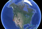
Now I know of one such spot where there is a gorge that is now totally underwater. It is near me, the Monterey bay (California coastline, in the contemptable USA) has a feature like this just off the coast. It is cut right through the shelf as if this land was once above sea level. In fact, you can see many smaller versions of these across the image that I have of it. No doubt they were important features in the local landscape.
I am going to give you some images of google earth, in case you do not have access, that show a great shelf that surrounds every continent. If this lower ocean is correct, which I expect that it really is, this shelf represents the original shoreline. Just how many times have I heard a story of some kind of structure just off the coast that is underwater a hundred of so feet down. Down in this shelf area.
Let us take a look at some of these. If we take this shelf as a baseline to all of these statements, in Indonesia you could have almost walked from the mainland across to Australia, without even seeing the ocean. Islands turn into mountains, shallow seas show up isolated from oceans. Like the sea that might have been there between China and Japan.
Onto the Russia and Alaska image. No, the cave man did not walk over ice floating on the ocean. There was no ocean. Many areas change when you look at this images in this manner. Like in Europe areas, there may have been no islands, you could walk to London from France. The Hawaiian Islands would have been huge almost connecting. Atlantean civilizations, or remnants of them, may have been in these areas, may still be there. How about this one, it puts Oak Island on a hill top, above sea level.
You have to wonder about just exactly what is off the coast, everywhere. You can see what a coastline represents in these days. It would most likely be containing a high portion of the population just like today’s coastline. Ports for ships, airports of UFO’s, who knows. Just kidding on the UFO airport, who needs a runway, you would think.
And I continue this session with just that. (I am sure that I am not the only one to have questioned this feature.) A UFO airport, just happen to have one. The last image is the odd remnants of something that was above sea level at one time, not too long ago. It is located at North 27° and West 109°30’ in the Gulf of California. Of note: this feature is over 80 miles long, was probably visible from space. The ultimate drag race, or a 500-mile race in just a couple of laps. Race you to the end …
There is a lot of speculation here, but there is one thing that is consistent around the shorelines of the globe. I see a shelf of land at about 200 to 250 feet below our current ocean level. Even 12,000 years could not wipe away that evidence. It does seem to have eroded over these years to a more flattened shelf, I suspect. Grinding away at the rolling hills of a coastline, of a time past, to the cliffs we see today. But you be the witness here and look for yourself. Haiku (MST) …
A recap for those that are still wandering the halls of knowledge here, before Venus entered our solar system as a comet and deposited a volume of water onto this planet via a close encounter, not just once, but twice. There were three passes of Venus, before its orbit got locked in to its current location in our solar system, that affected our world. One of these cometary orbits of Venus, before our encounters, affected Mars in a more drastic fashion. Venus removed almost all of the surface liquids from Mars quite possibly from dragging its tail across the surface, while it was still a comet. You can see this in the great scar on the planet, investigate it for yourself. Venus’ mass being greater enabled this to happen. Now when Venus passed our world it transferred elements that it previously stole from Mars, is now transferred to us due to our mass is larger than Venus. Again, this did not just happen on a single occasion. We got hit multiple times.
Two of these events are recorded as Noah’s Flood (12,000+ Years ago) as the first transfer and the Great Deluge (8,000+ YA) as the second transfer. And to note the last pass of Venus affected Atlantis itself (4,000 YA). The Chateau has done their homework on this and have shared some pretty conclusive dates of these events over the years.
Venus’ orbit during these events would have been interesting to say the least. Venus was traveling through our solar system to do what it did to Mars. But the events that are accounted to us here on Earth may look to have been done to us during it last phase. This is where it would be orbiting our Sun but not in a concentric procession. It would be perturbed with an elliptical path that brought it close to Mercury at its closest point but swung it close to our orbit at its furthest point. I suspect that it was one of far reaches that intermingled with our world and these transfer events happened.
Let’s take a look now at the volume of these transfer events. What we are talking about is the almost total removal of all surface liquids from the planet Mars. I will have to use Earth as an example. We have roughly one half cubic mile of water per every square mile of surface here, at this current time. This is a lot of water. Let us give Mars the benefit of the doubt and say that they had the same concentration of water, or liquids, on its surface (pure speculation). Mars is about one quarter the size of earth. We will give them one quarter the volume of water on earth. I do not believe that we only got water, we got more than that. In fact, Venus probably gave Mars a good cleaning of all surface elements not fully battened down. But back to our ocean level increase. This could mean that we got one quarter of our water resident in our oceans from Mars. There is a great portion of speculation here, but this could mean an ocean level that could have been hundreds of feet lower than it is today.
Our world would have been a different place with less ocean surface then we have now. And in theory, this was done not too long ago, so what the world was, should still be visible.
If the theory is right, then the world went from one state of ocean level and then rose a hundred or more of feet 12,000 years ago and again four thousand years later. And in time perspective, the time that our ocean was deeper is a minor percentage of the time that it was in its previous depth. This would show as a second shoreline, just below the surface somewhere. It would have features such as river gorges where water cut hillsides over a great expanse of time.
A tool to use to see this. Google Earth should fit the bill. I have it loaded locally on my computer, but it looks the same on-line.
Now I know of one such spot where there is a gorge that is now totally underwater. It is near me, the Monterey bay (California coastline, in the contemptable USA) has a feature like this just off the coast. It is cut right through the shelf as if this land was once above sea level. In fact, you can see many smaller versions of these across the image that I have of it. No doubt they were important features in the local landscape.
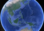
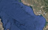
I am going to give you some images of google earth, in case you do not have access, that show a great shelf that surrounds every continent. If this lower ocean is correct, which I expect that it really is, this shelf represents the original shoreline. Just how many times have I heard a story of some kind of structure just off the coast that is underwater a hundred of so feet down. Down in this shelf area.
Let us take a look at some of these. If we take this shelf as a baseline to all of these statements, in Indonesia you could have almost walked from the mainland across to Australia, without even seeing the ocean. Islands turn into mountains, shallow seas show up isolated from oceans. Like the sea that might have been there between China and Japan.
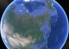
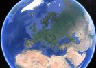
Onto the Russia and Alaska image. No, the cave man did not walk over ice floating on the ocean. There was no ocean. Many areas change when you look at this images in this manner. Like in Europe areas, there may have been no islands, you could walk to London from France. The Hawaiian Islands would have been huge almost connecting. Atlantean civilizations, or remnants of them, may have been in these areas, may still be there. How about this one, it puts Oak Island on a hill top, above sea level.
You have to wonder about just exactly what is off the coast, everywhere. You can see what a coastline represents in these days. It would most likely be containing a high portion of the population just like today’s coastline. Ports for ships, airports of UFO’s, who knows. Just kidding on the UFO airport, who needs a runway, you would think.
And I continue this session with just that. (I am sure that I am not the only one to have questioned this feature.) A UFO airport, just happen to have one. The last image is the odd remnants of something that was above sea level at one time, not too long ago. It is located at North 27° and West 109°30’ in the Gulf of California. Of note: this feature is over 80 miles long, was probably visible from space. The ultimate drag race, or a 500-mile race in just a couple of laps. Race you to the end …
There is a lot of speculation here, but there is one thing that is consistent around the shorelines of the globe. I see a shelf of land at about 200 to 250 feet below our current ocean level. Even 12,000 years could not wipe away that evidence. It does seem to have eroded over these years to a more flattened shelf, I suspect. Grinding away at the rolling hills of a coastline, of a time past, to the cliffs we see today. But you be the witness here and look for yourself. Haiku (MST) …