Sumatra - 8.9 Earthquake

Laura

Administrator
Administrator
Moderator
FOTCM Member
Indian Ocean tsunami watch issued after massive earthquake hits Indonesia coast

By Associated Press, Updated: Wednesday, April 11, 11:45 AM AP

BANDA ACEH, Indonesia — A tsunami watch was issued for countries across the Indian Ocean after a large earthquake hit waters off Indonesia on Wednesday, triggering widespread panic as residents along coastlines fled to high ground in cars and on the backs of motorcycles.

Some were crying. Others screamed “God as great” as they poured from their homes.

The U.S. Geological Survey said the 8.7-magnitude quake was centered 20 miles (33 kilometers) beneath the ocean floor around 269 miles (434 kilometers) from Aceh’s provincial capital.

The Pacific Tsunami Warning Center in Hawaii said a tsunami watch was in effect for Indonesia, India, Sri Lanka, Australia, Myanmar, Thailand, the Maldives and other Indian Ocean islands, Malaysia, Pakistan, Somalia, Oman, Iran, Bangladesh, Kenya, South Africa and Singapore.

A tsunami watch means there is the potential for a tsunami, not that one is imminent.

Said, an official at Indonesia’s Meteorology and Geophysics Agency who goes by only one name, said a tsunami warning has been issued for cities all along the coast of Sumatra island.

There was chaos in the streets, with fierce shaking continuing for nearly four minutes.

...

The tremor was felt in Singapore, Thailand, Bangladesh, Malaysia and India. High-rise apartments and offices on Malaysia’s west coast shook for at least a minute.
...

Indonesia straddles a series of fault lines that makes the vast island nation prone to volcanic and seismic activity.

A giant 9.1-magnitude quake off the country on Dec. 26, 2004, triggered a tsunami in the Indian Ocean that killed 230,000 people, nearly three quarter of them in Aceh.
 
They have cancelled the tsunami warning now, according to web-media. The quake was more horizontal than vertical and thus didn't generate any tsunami waves, it seems.
 
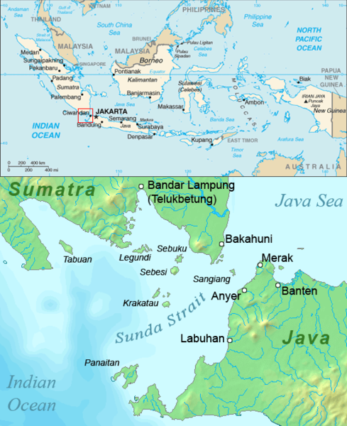
I was looking at maps of this earthquake and we see it here:

stories_tsunami_maps.jpg


I thought to myself: "hmmm... how close is that to Anak Krakatau which has been blasting a bit lately?

Here is the location of the volcano:

Sunda_strait_map_v3.png


Wonder if there is any connection, like a looming big bang from Anak Krakatau???
 
Another Krakatau eruption as big as the eruption from the late 19th century could kill millions of people - hope the quake doesn't trigger the volcano.
 
Hithere said:
There has been an afterquake measured at 8.2 and they have reissued a tsunami warning.

Yeah, two strong ones...

M8.2 - off the west coast of northern Sumatra 2012-04-11 10:43:09 UTC

http://earthquake.usgs.gov/earthquakes/eventpage/usc00090da#summary

Event Time

2012-04-11 10:43:09 UTC
2012-04-11 16:43:09 UTC+06:00 at epicenter
2012-04-11 12:43:09 UTC+02:00 system time

Nearby Cities

476km (295mi) WSW from Sinabang, Indonesia
552km (342mi) SW from Meulaboh, Indonesia
617km (383mi) SSW from Banda Aceh, Indonesia
641km (398mi) SW from Sigli, Indonesia
1060km (658mi) WSW from Kuala Lumpur, Malaysia
 
The copy of the CNN article on "The Extinction Protocol" includes the
sentence: "The massive earthquake was followed by a *6.0* in the north
Indian Ocean and then a *8.2* earthquake near the main epicenter. "


See below:


*April 11, 2012* âEUR" *INDONESIA* - A massive earthquake
struck off the coast of the Indonesian island of Sumatra on
Wednesday afternoon, triggering a tsunami alert for the Indian
Ocean. The quake struck about 434 kilometers (270 miles)
southwest of Banda Aceh, the capital of Indonesia's Aceh
province, and had a magnitude of *8.6*, the U.S. Geological
Survey said. It took place at a depth of 23 kilometers (14
miles). The massive earthquake was followed by a *6.0* in the
north Indian Ocean and then a *8.2* earthquake near the main
epicenter. The tremor revived fearful memories of the
catastrophic earthquake and tsunami in the region in 2004 that
killed tens of thousands of people. The Pacific Tsunami
Warning Center said Wednesday that it had issued a tsunami
watch for the entire Indian Ocean, and the Indonesian
Meteorology, Climatology and Geophysics Agency said it had put
up a tsunami warning. The Indonesian president, Susilo Bambang
Yudhoyono, said on local television that there were no reports
of casualties or damage in Aceh so far. The areas most at risk
of a tsunami are coastal areas of Aceh, particularly the
island of Simeulue, Prih Harjadi, an official for the
Indonesian geophysics agency said on Metro TV. The earthquake
appears to have involved a horizontal movement rather than a
vertical movement, so it is less likely that it will generate
a tsunami, said Gary Gibson from the Seismology Research
Center in Melbourne, Australia. He also said that the tremor
took place a long way offshore and was therefore unlikely to
have caused much damage itself. The power has gone out in
Banda Aceh and residents are moving to higher ground, said
Sutopo Purwo Nugroho, a spokesman for the Indonesian National
Disaster Management Agency. The authorities in India's Andaman
and Nicobar Islands have ordered people to move out of
low-lying areas. -*CNN*

http://www.cnn.com/2012/04/11/world/asia/indonesia-earthquake/index.html?eref=igoogledmn_topstories


But, when you click the link and go to the CNN article, that sentence is
not there.

The Seismic Monitor here: http://www.iris.edu/seismon/

has three red rings on the site which means, I think, THREE earthquakes.

When you click their "last 30 days" link, there are, indeed, three
earthquakes listed:

DATE LAT LON MAG DEPTH km REGION
11-APR-2012 10:43:09 0.77 92.45 8.2 16.4 OFF W COAST OF NORTHERN SUMATERA
11-APR-2012 09:27:56 1.28 91.73 6.0 9.8 NORTH INDIAN OCEAN
11-APR-2012 08:38:38 2.35 93.07 8.7 33.0 OFF W COAST OF NORTHERN SUMATERA


So, it seems to me that CNN deleted that sentence for some reason.
 
I lived in Banda Aceh in 2007, went there to help in the reconstruction efforts after the 2004 tsunami. We used to have earthquakes daily and some of them were really scary, as the houses would shake up and down, still have friends there and seeing this news brings sad memories.

But the magnitudes are increasing, and now there are more and more over 7 or 8 points. The Earth changes are quite noticiable, and I just think that part of the world is a bit more vulnerable because of the geographical situation and the lack of proper structures. Probably not the last big one we will see this year in Indonesia.
 
I find it interresting that Piers Corbyn predicted a high probability of a strong earthquake in the northern hemisphere a few days ago (saw it on twitter).

Posted by Piers Corbyn (Twitter) on Apr 9th 2012, 2:22 AM EDT
Impressive Coronal Holes moving to center of solar disc for April 9th as we predicted. Coronal holes image is for 8th which means the biggest one will be Earth-Facing (EF) on 9th, the middle of our 8-10th period.

_http://spaceweather.com/archive.php?day=09&month=04&year=2012&view=view

Note the official forecasts say to expect solar wind from these holes to hit Earth ~12-13th. This may be true but our work shows the important time for (earlier) influences giving Eartthquakes is when the holes are EF, give or take a day.

The point is that earthquake probablity is increased when a coronal hole is facing the earth, suggesting maybe an electromagnetic connection.


Edit:

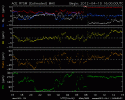
Not sure yet what how the different components are arranged but it can be seen (on the attached picture) that the Interplanetary Magnetic Field underwent an important variation when the earthquake occured (look at the By component).
 

Attachments

  • Mag_24h.gif
    Mag_24h.gif
    13.2 KB · Views: 6
I also saw this on Twitter and immediately googled for articles. The thing with Twitter is you find out about these things so quickly that when you're hunting for information no news outlet has written an article yet.

Nonetheless, it gave me enough time to contact my mother, who was currently vacationing on the southern tip of Thailand. I instructed her to move inland, away from the west coast. She's my only remaining family (we lost everyone else to various health problems over the past year) so I wasn't about to let a tsunami get anywhere near her. Especially now she's finally gone grain free ;) As it turns out there wasn't much danger at that distance, but you never really know the true level of danger until it's too late.

As Hithere said, it was horizontal and didn't have much effect. But it's the quakes that occur afterwards that concern me. I for one would not want to live anywhere near the edge of a tectonic plate! Or a volcano.

*checks under doormat for volcano*
 
*checks under doormat for volcano* :thup:

My dog keeps moving my doormat. Never know where the earthquake will strike around here!
 
Nathan said:
I for one would not want to live anywhere near the edge of a tectonic plate! Or a volcano.
I hear ya! i live in the Dominican Republic, and it's on my mind even if these big boys werent near me, since people keep saying we're due for a big one. Ever since the Haiti one, i dislike earthquakes even more. I'd rather deal with a bunch of hurricanes, honestly :/

Glad to hear your mom is doing well. Nathan.

I'm really keeping Sumatra and that whole region in my thoughts; those are just massive quakes they're getting.
 
Laura said:
11-APR-2012 08:38:38 2.35 93.07 8.7 33.0 OFF W COAST OF NORTHERN SUMATERA
The site now shows "8.6" where the "8.7" used to be, so that's the Big One, plus two afterquakes, accounted for.

Laura said:
So, it seems to me that CNN deleted that sentence for some reason.
Non, non, Le Protocole d'Extinction edits (truncates, rewrites, etc) articles it gets from mainstream news sources. The CNN original mentions the 8.2 one.

mkrnhr said:
Not sure yet what how the different components are arranged but it can be seen (on the attached picture) that the Interplanetary Magnetic Field underwent an important variation when the earthquake occured (look at the By component).
Thanks for the graph. Does it mean the IMF "went" in a northwest direction at the time of the quake?

mkrnhr said:
The point is that earthquake probablity is increased when a coronal hole is facing the earth, suggesting maybe an electromagnetic connection.
Certainly! :) If the Electromagnetic Universe Theory were taught in schools, we wouldn't be having this problem. Coronal holes anywhere else other than the sun's poles means an "almost" polar reversal, I think. Just the intermediate phase when the poles are fragmented all over the sun and haven't reassembled. So having a coronal hole pointing at you is like having one of the sun's poles pointing at you. Like a massive bar magnet pointing at earth. Something's bound to happen.

And I have to thank a thunderbolts article for telling me about "conduits". Meaning, a "conduit" forms between heaven and earth, discharge occurs, magma spews out of volcanoes, lightning connects ground and sky, the earth trembles at subduction zones. Tornadoes are a manifestation of this too. And we can extrapolate this to the sun...a weak conduit between the coronal hole and earth. The Extinction Protocol (and the IRIS seismology site) showed the quake pattern: Indonesia/Indian Ocean > Atlantic Ocean > Mexico > Oregon.
 

Trending content

Back
Top Bottom