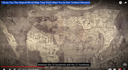
We all know these search engines knows our tastes and throws some thing at us and out of which some picks our curiosity. Few days back, one of the Graham Hancock video showed on the youtube right side ribbon. The theme is typical of Hancock's thesis - Ancient knows more and maps are depiction of it. Some old maps were shown though most discussion is about Piri Reis map.
We all know C's said Piri Ries map dates back to 14,000 BCE . Obviously, European rulers wanted these maps for their funding of so called explorations and need directions. So some picked what they have in possession and tried to create maps. We don't know how accurate these are w.r.t each geographic area and the source maps they used. It may be accurate at the time of source map, may not be later vice versa. or complete/part fabrication. Too many variables there .
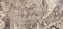
Here is article about the "economy" of the time. The name "America" popped up with this Waldseemüller map for the first time in the honor of Italian explorer Amerigo Vespucci, who claims to have landed on the continent before Christopher Columbus

 www.bbc.com
Here is the clearer map I could find is here. https://i.natgeofe.com/n/70ca817d-0834-4b40-ae67-a63a6ea4893e/1262849_2x1.JPG

Focusing on the Indian continent is VERY interesting for few reasons for me. This is ASSUMING that this author drawing is based on some very old accurate map which was accurate ( in ancient time) and he simply recopied those areas.

Dragon's tail (Peninsula) (marked as Red 3)- Thailand and Malaysia
Here is article about the "economy" of the time. The name "America" popped up with this Waldseemüller map for the first time in the honor of Italian explorer Amerigo Vespucci, who claims to have landed on the continent before Christopher Columbus

The epic story of the map that gave America its name
A few hundred years ago, when much of the world was mysterious and unknown, two European humanists came together to produce an extraordinary map of the world.
Few images from the above Video picked my curiosity for the strange geography of Indian subcontinent. Taking screenshot of it and browser image search led to me to this Waldseemüller map. It looks Piri Reis map doesn't have South Asia in it....
The map, printed in 1507, measured about 1.4m by 2.4m, a size that matched its grand ambition to portray the world in its entirety. And indeed, it did depict more of the world than ever before. For centuries, Europeans had believed that the world was made up of three landmasses: Asia, Africa and Europe, with Jerusalem at its centre. That’s why Italian explorer and coloniser for Spain, Christopher Columbus, had gone to his deathbed just a year earlier believing that where he had landed in the Americas was just another part of Asia. However, this new map depicted a fourth part of the world for the first time. To the left of Europe, it showed a long, thin version of South America, with a small-sized North America above it. The new continent was surrounded by water, and, on the part that is known today as Brazil, the map-makers placed a name: America.
...
That these two Germans came together to undertake such as project in St-Dié-des-Vosges was not simply a question of money. The location of the town was also significant. As Toby Lester told me, “You had explorers setting off from the Atlantic coast in Spain and Portugal, who were bringing all their information back there, and the Italians who were funding and going on these expeditions, churning through a lot of the information, and the Germans in the middle, doing strong, leading work with printing.” St-Die, near Strasbourg, Basel and Freiburg, was, like other locations that set up printing presses, at a convergence where information could move back and forth easily.
...
Ultimately, the Waldseemüller map reminds us that all maps are political. By putting north at the top of the map, whereas the previous convention was to place east at the top, and placing Europe at the middle, makes it literally Eurocentric. The decision of the map-makers to name an entire, inhabited continent after a European man who went there, privileges the European perspective and demonstrates the European attitude and ambition of the time. It is an outlook that predicts the way in which the Europeans would continue to take possession of lands, resources and people, erasing cultures and killing millions.
Here is the clearer map I could find is here. https://i.natgeofe.com/n/70ca817d-0834-4b40-ae67-a63a6ea4893e/1262849_2x1.JPG

Focusing on the Indian continent is VERY interesting for few reasons for me. This is ASSUMING that this author drawing is based on some very old accurate map which was accurate ( in ancient time) and he simply recopied those areas.

- Current Indian geography as a one piece is not there in this Map.
- C's said Indian plate got attached to Eurasian plate around 70K YA. Obviously I assumed current land is similar to 70K YA though I have some reservations to my question. I looked for some clues whether North Indian piece came first and south Indian piece came later. But couldn't find much in that direction.
- C's said also said there is a submerged area ( continent/region/city) called "Kumara Kandam" and it was later than ( "Closer") than Younger Dryas Period ( 10K BCE approx.) Kumara Kandam proponents used the shape of this island ( Taprobane - middle of the above picture marked as Red 1). Kumara Kandam proponents call Sri Lanka is part of Kumara Kandam.
- Currently, Historians associate Taprobane as the old name of Sri Lanka.
- And you have this Ramayan Story that starts with hero "Rama" in Ayodya (in North India) and ends up down in to Lanka killing its king "Ravana" ( fictious being based on comets) for abducting Rama's Wife "Sita". Hero's rescuing "Abducted" woman after "good vs evil" battle. is common mythical theme.
- There was an endless debate related to Origin of the word "India" that often the form of "Left vs Right" battle. British Indologists insist that the name is give by Arabs/Musilsm for any thing beyond "Indus" River. But locals quote old texts calling it "JambuDweep" . Dweep means Island.
- VedVeer Arya's (VA) chronology gives very interesting clues
- Earlier version Sanskrit texts talk as if southern part of north India is border of "JambuDweep".
- "Jambu" comes from a character called Jambavan. JambuDweep aka "island of Jambavan". VA places him in the Dwarika ( West India - marked as 2 in the above map), place in the northern part of India. C's already said there is a submerged place called 'Dwarika' went down around Younger Dryas period.
- In this map which is based on
- Is this Waldseemüller map's depiction of Indian subcontinent is accurate at any time?
- If true, how many years old back this geography is accurate.
- If true, When did the last time current India subcontinent geography formed.
Dragon's tail (Peninsula) (marked as Red 3)- Thailand and Malaysia
Few other Interesting observations from MapThe Dragon's Tail is a modern name for the phantom peninsula in southeast Asia which appeared in medieval Arabian and Renaissance European world maps. It formed the eastern shore of the Great Gulf (Gulf of Thailand) east of the Golden Chersonese (Malay Peninsula), replacing the "unknown lands" which Ptolemy and others had thought surrounded the "Indian Sea".
...
Early history
The peninsula does not appear in any surviving manuscript of Ptolemy's Geography or other Greek geographers. Instead, it is first attested in the Ptolemaic-influenced Book of the Description of the Earth compiled by al-Khwārizmī around 833 AD. Ptolemy's map ended at 180°E of the Fortunate Isles without being able to explain what might lie on the imagined eastern shore of the Indian Ocean or beyond the lands of the Sinae and of Serica in Asia. Chinese Muslims traditionally credit the Companion Saʿd ibn Abi Waqqas with having missionized the country as early as the 7th century; the trading community was large enough that a large-scale massacre is recorded at Yangzhou in 760.[2][3] Merchants such as Soleiman showed Al-Khwārizmī that the Indian Ocean was not closed as Hipparchus and Ptolemy had held but opened either narrowly or broadly. Al-Khwārizmī left most of Ptolemy's eastern coast but the creation of the strait created a new peninsula, beyond which he placed the Sea of Darkness and the Island of the Jewel.[4][5]
...
The Portuguese were aware of the peninsula's likely nonexistence by shortly after the fall of Malacca, when Albuquerque acquired a large Javanese map of Southeast Asia.[17] The original was lost aboard the Froll de la Mar shortly afterwards[18] but a tracing by Francisco Rodrigues was sent in its place as part of a letter to the king.[note 1] Nonetheless, published maps continued to include it in different forms for another century.
- There are few words keep popping up in this map. Probably it is reflection of "Obsession" of India among european explorers of that time.
- Libia, Ethiopia through out Africa
- India across Asia - India superior, India meri Dionalis in current Chinese region, India in South East region.
- Keep in mind many of the Hindu God's still exist in the South East Asian countries even to this day. Ramayan is very popular even to this date. Though it is attributed to south Indian empire's influence 2000 years back.
- Tartaria , Scithia in the Russian region.
- If this dragon's tail is geographical reality long time back, Probably this is a mess resulted from Toba super volcano that destroyed this region 70K years ago?
- This also raises question of origin of the word "India". At one point in the long past, did Paranthas ( or Denisovans) are called this ocean as "Indian ocean". I don't mean exact word "India" as such but some thing equivalent of it in the languages of that time?
Last edited:
