Are there not humans who care about the planet?Unfortunately, humans ruin everything...
You are using an out of date browser. It may not display this or other websites correctly.
You should upgrade or use an alternative browser.
You should upgrade or use an alternative browser.
Tribute to Planet Earth 🌎 ♥️
- Thread starter bjorb
- Start date
Many people definitely care about the planet. I pulled around 75 tires out of the small creek below my house and carried lots of laundry bags worth of trash out of the creeks and rivers I fish and still do, though not as much as I used to. It was an interesting experience in a way while doing it, like I was on the front lines of the STO/STS battle. But ultimately I think it’s needed, at least individually we are signaling to the universe which side we are on by our actions.Are there not humans who care about the planet?
So there’s enough humans who genuinely care about the planet, at least in my estimation because I see organizations like the Savory Institute, places like Whiteoak Pastures and many other individuals who are going back to regenerative farming. It just seems like a natural process that eventually we’ll all come together, however that plays out.
Your work there in France is incredibly important, and people like Dr. Malone are now writing about Ponerology and that can lead people right to the C’s, so information is spreading. Those who care are being forced to take action and eventually we’ll find ourselves on the other side of this mess.
In any case, to hell with all the darkness. There’s simply no way to live in the world they’re creating.
PERLOU
The Living Force

Le Moigne Adrien
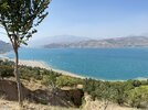
Ce sont des couleurs que l'on appelle glaz en breton, une couleur qui regroupe le vert, le bleu et le gris. Une couleur typiquement breton...
These are colors that we call glaz in Breton, a color that includes green, blue and gray. A typically Breton color...


bjorb
The Living Force
XPan
The Living Force
Candidates for the Weather Photographer of the year 2022 (part I)
Royal Meteorological Society
In the following entries i will show some fascinating images which people have done, being part of the Weather Photographer of the year 2022 Contest, arranged by the Royal Meteorological Society. The Photo site dPreview wrote about it (presented the images), as well the site from Royal Meteorological Society.
 www.dpreview.com

 www.rmets.org
Here are some of the images:

"Dam Wet": by Andrew McCaren
Photo location: Shap, UK
Camera: Canon 1DX with 70-200 2.8L lens.
Days of heavy rain in the UK led to water cascading down the dam wall of Wet Sleddale reservoir near the village of Shap in Cumbria. Andrew captured this photo as he wanted to illustrate the heavy rain and strong winds brought to the UK by Storm Dennis in February 2020.
"Wet Sleddale more often than not doesn't overflow, but when it does, it's an amazing site, and the noise is deafening".
Storm Dennis impacted the UK on 15-16 February 2020, bringing high rainfall totals and causing flooding in parts of south Wales and England. Strong winds were also associated with the storm, with Aberdaron in northwest Wales recording a wind gust of 91mph.
Storm naming came into force in the UK in 2015 based on criteria combining the weather's impact and the likelihood of those impacts. Storms impacting the UK are named by the Met Office (UK weather service), the Irish weather service Met Éireann or the Dutch weather service KNMI.

"Waterspout in Barcelona": by Carlos Castillejo Balser
Photo location: Barcelona, Spain
Camera: Canon EOS 6D
Carlos arrived in the dark, early morning to watch a big storm form over Barcelona. "As dawn was breaking, I could see a large waterspout sliding down in front of the harbour. From time to time, a flash of lightning illuminated the scene".
A waterspout is a rotating column of air that forms over water or moves from land to water. There are two types of waterspouts, fair weather waterspouts and tornadic waterspouts. Fair weather waterspouts are not usually associated with thunderstorms.
Less common but more violent tornadic waterspouts, such as this example, form over the water or move from the land to water, with the same characteristics as land tornadoes. They develop from cumulonimbus clouds or thunderstorms. These columns of rotating air extend downwards from the cloud and touch the water surface, often accompanied by strong winds, high seas, large hail and frequent lightning.

"Thunder in Chongquing": by Luo Xing
Photo location: Chongqing, China
Camera: Sony A7RII with Nikon 14-24 mm lens
During the early hours of the night, Luo captured this photo of lightning strikes over Chongqing in China.
Lightning is a sudden, electrostatic discharge in the atmosphere in the form of a 'spark' or a 'flash'. Electricity can discharge between clouds, from a cloud to air or from a cloud to the ground. Lightning is associated with thunderstorm clouds, also known as cumulonimbus clouds, and these clouds can typically form in under an hour.
Inside a cumulonimbus cloud, particles of rain, snow or ice move up and down, colliding and causing an imbalance in the electrical charge. Cloud-to-ground lightning, as seen in this image, happens when a channel of negative charge zigzags downward in a 'forked pattern'. This is usually invisible to the human eye and travels to the ground in a millisecond. As it nears the ground, it attracts a positive charge reaching up from a tall building, tree or telegraph pole. When the two connect, a powerful electrical current travels at about 60,000 miles per second back to the cloud as a very bright, visible flash of lightning.

"Dreaming of lightning" by Eric Nararrete Bachs
Photo location: Sant Pol de Mar, Barcelona, Spain
Camera: Sony A7II with FE 24-70mm
On a full moon night, with a storm moving away and one last lightning strike, was what photographer Enric called 'dream lightning'.
Thunderstorms are common on Earth, and it is estimated that a lightning strike hits somewhere on the Earth's surface approximately 44 times every second. Thunderstorms are most common in tropical areas where the weather is hot and humid, with places such as Lake Maracaibo in Venezuela receiving the most lightning strikes.
The rapid expansion and heating of air caused by lightning is what produces the accompanying loud clap of thunder. Since light travels faster than sound, you can tell how far a thunderstorm is away by counting the number of seconds between the flash of lightning and the sound of the thunder that follows. If you divide this number by five, it will tell you how many miles away the storm is from you (or you can divide by three for the distance in kilometres).
Royal Meteorological Society
In the following entries i will show some fascinating images which people have done, being part of the Weather Photographer of the year 2022 Contest, arranged by the Royal Meteorological Society. The Photo site dPreview wrote about it (presented the images), as well the site from Royal Meteorological Society.
Slideshow: The shortlisted photographs for the 2022 Weather Photographer of the Year contest
The Royal Meteorological Society has announced the shortlisted images for its 2022 Weather Photographer of the Year photo competition, highlighting incredible scenes of mother nature from around the globe.
www.dpreview.com
Royal Meteorological Society
The Royal Meteorological Society is the Learned and Professional Society for weather and climate. Our mission is to promote the understanding and application of meteorology for the benefit of all.
www.rmets.org
Here are some of the images:
"Dam Wet": by Andrew McCaren
Photo location: Shap, UK
Camera: Canon 1DX with 70-200 2.8L lens.
Days of heavy rain in the UK led to water cascading down the dam wall of Wet Sleddale reservoir near the village of Shap in Cumbria. Andrew captured this photo as he wanted to illustrate the heavy rain and strong winds brought to the UK by Storm Dennis in February 2020.
"Wet Sleddale more often than not doesn't overflow, but when it does, it's an amazing site, and the noise is deafening".
Storm Dennis impacted the UK on 15-16 February 2020, bringing high rainfall totals and causing flooding in parts of south Wales and England. Strong winds were also associated with the storm, with Aberdaron in northwest Wales recording a wind gust of 91mph.
Storm naming came into force in the UK in 2015 based on criteria combining the weather's impact and the likelihood of those impacts. Storms impacting the UK are named by the Met Office (UK weather service), the Irish weather service Met Éireann or the Dutch weather service KNMI.
"Waterspout in Barcelona": by Carlos Castillejo Balser
Photo location: Barcelona, Spain
Camera: Canon EOS 6D
Carlos arrived in the dark, early morning to watch a big storm form over Barcelona. "As dawn was breaking, I could see a large waterspout sliding down in front of the harbour. From time to time, a flash of lightning illuminated the scene".
A waterspout is a rotating column of air that forms over water or moves from land to water. There are two types of waterspouts, fair weather waterspouts and tornadic waterspouts. Fair weather waterspouts are not usually associated with thunderstorms.
Less common but more violent tornadic waterspouts, such as this example, form over the water or move from the land to water, with the same characteristics as land tornadoes. They develop from cumulonimbus clouds or thunderstorms. These columns of rotating air extend downwards from the cloud and touch the water surface, often accompanied by strong winds, high seas, large hail and frequent lightning.
"Thunder in Chongquing": by Luo Xing
Photo location: Chongqing, China
Camera: Sony A7RII with Nikon 14-24 mm lens
During the early hours of the night, Luo captured this photo of lightning strikes over Chongqing in China.
Lightning is a sudden, electrostatic discharge in the atmosphere in the form of a 'spark' or a 'flash'. Electricity can discharge between clouds, from a cloud to air or from a cloud to the ground. Lightning is associated with thunderstorm clouds, also known as cumulonimbus clouds, and these clouds can typically form in under an hour.
Inside a cumulonimbus cloud, particles of rain, snow or ice move up and down, colliding and causing an imbalance in the electrical charge. Cloud-to-ground lightning, as seen in this image, happens when a channel of negative charge zigzags downward in a 'forked pattern'. This is usually invisible to the human eye and travels to the ground in a millisecond. As it nears the ground, it attracts a positive charge reaching up from a tall building, tree or telegraph pole. When the two connect, a powerful electrical current travels at about 60,000 miles per second back to the cloud as a very bright, visible flash of lightning.
"Dreaming of lightning" by Eric Nararrete Bachs
Photo location: Sant Pol de Mar, Barcelona, Spain
Camera: Sony A7II with FE 24-70mm
On a full moon night, with a storm moving away and one last lightning strike, was what photographer Enric called 'dream lightning'.
Thunderstorms are common on Earth, and it is estimated that a lightning strike hits somewhere on the Earth's surface approximately 44 times every second. Thunderstorms are most common in tropical areas where the weather is hot and humid, with places such as Lake Maracaibo in Venezuela receiving the most lightning strikes.
The rapid expansion and heating of air caused by lightning is what produces the accompanying loud clap of thunder. Since light travels faster than sound, you can tell how far a thunderstorm is away by counting the number of seconds between the flash of lightning and the sound of the thunder that follows. If you divide this number by five, it will tell you how many miles away the storm is from you (or you can divide by three for the distance in kilometres).
XPan
The Living Force
Candidates for the Weather Photographer of the year 2022 (part II)
Royal Meteorological Society

"Storm Eunice" by Christopher Ison
Photo location: Newhaven, East Sussex, UK
Camera: Canon EOS R5
After checking the time Storm Eunice would hit as well as the high tides times, Christopher discovered that the storm would hit Newhaven, East Sussex, at almost exactly high tide. When taking his photo, Christopher decided to head to high ground and stand slightly further away from the harbour wall with his back to the weather and was rewarded with a fantastic set of images.
"When the storm was predicted and that it was carrying the first ever red warning for the south coast, I knew I had to find a spot to record it – this was going to be big!"
Storm Eunice was a deep area of low pressure that hit the UK in February 2022. It was particularly disruptive as it underwent explosive cyclogenesis when a low-pressure system rapidly deepens. Low pressure systems can bring heavy rain/snow and strong winds, and the deeper the area of low pressure relative to the surrounding pressure, the stronger the winds will be.

"Mock Mirage Sunset over the Estuary" by Brendan Conway
Photo location: Tankerton, Kent, UK
Camera: Nikon COOLPIX P900
During a beautiful, calm evening in Tankerton, Kent, Brendan captured this image of people walking along the famous shingle Street, exposed at low tide, as they were treated to a spectacular mock mirage sunset over the Thames Estuary. He says that "a bonus mirage caused buildings in Southend to appear to levitate".
"I hope that when people look at the photo, they not only enjoy the aesthetic dimension but will also be prompted to think a bit more deeply about the incredible processes that brought it about. It was a memorable and unexpected sunset. Inadvertently, the photograph captured some unusual phenomena and hopefully provided a thought-provoking catalyst for deeper knowledge about the atmosphere".
During a mock mirage sunset, the sun is distorted and appears to be sliced horizontally. This can occur when there are one or more shallow layers in the atmosphere with a temperature difference between each layer, known as temperature inversions. The sunlight is refracted more as it travels through colder layers than warmer ones distorting how an object appears to a viewer.
This photograph also captures an inferior mirage where the distant buildings in Southend appear to be elevated above their normal position. An inferior mirage is also an optical phenomenon due to a temperature inversion.

"Frozen" by Zhenhuan Zhou
Photo location: Ontario, Canada
Camera: Canon EOS 5D Mark IV
Zhenhuan captured this photo showing parts of Niagara Falls covered in ice.
During spells of cold weather, the mist and spray from Niagara Falls can freeze into ice over the top of the rushing water of the waterfall, giving the appearance that the Falls have frozen whilst the water continues to flow underneath the sheets of ice.
However, there are records that the Falls' waters did stop once in March 1848. Strong winds pushed ice from Lake Erie into the mouth of the Niagara River, blocking the channel completely and stopping the water for about 30 hours. The wind then shifted, and the built-up weight of the water broke through the ice, forcing the Niagara River to flow again.
The photograph offers intricate detail of the icicles that have formed around the building and on the rock face. Icicles are hanging tapering pieces of ice that form when the temperature is below freezing. As water drips off the roof or rock, it freezes and becomes suspended in the shape of a droplet. As more water droplets flow over the surface, they freeze on the way down, and so the process continues until an icicle is formed.

"Waterlily Harvesting" by Shibasish Saha
Photo location: Barrackpore, West Bengal, India
Camera: DJI Mavic 2 Pro Drone
During the monsoon season in the wetlands of West Bengal, Shibasish captured this image of people collecting waterlilies to sell in the local market.
A monsoon is a seasonal change in the direction of the prevailing winds of a region, bringing a marked difference in rainfall. Monsoons lead to distinct wet and dry seasons in many parts of the tropics and often occur in and around the Indian Ocean. They are driven by a strong temperature difference between the land and sea, effectively like a large-scale sea breeze.
The Asian monsoon is the most widely known, but monsoon conditions also occur (though to a lesser degree) in other regions, including northern Australia, parts of western, southern and eastern Africa and parts of North and South America.

"Solar Halo, Antarctica" by Thomas Chitson
(Solar Halo making an appearance over Adelaide Island Antarctica)
Photo location: Rothera Research Station, Antarctica
Camera: Google Pixel 4a
Whilst out Nordic skiing from the Rothera research station in Antarctica, Thomas captured this beautiful sun halo. "Good weather was rare on the icy continent, but when the sun was shining, solar haloes were a common phenomena during my three months spent researching the weather and climate in Antarctica".
Haloes around the sun or moon occur when the light is refracted or reflected by ice crystals, normally found in high cirrus or cirrostratus clouds or free-falling ice crystals. Typically, sunlight or moonlight is reflected by ice crystals producing a white halo either around the sun or moon. However, if the light rays strike the ice crystals at a particular angle, then some light may be refracted, giving the halo a faint colouration.
Royal Meteorological Society
"Storm Eunice" by Christopher Ison
Photo location: Newhaven, East Sussex, UK
Camera: Canon EOS R5
After checking the time Storm Eunice would hit as well as the high tides times, Christopher discovered that the storm would hit Newhaven, East Sussex, at almost exactly high tide. When taking his photo, Christopher decided to head to high ground and stand slightly further away from the harbour wall with his back to the weather and was rewarded with a fantastic set of images.
"When the storm was predicted and that it was carrying the first ever red warning for the south coast, I knew I had to find a spot to record it – this was going to be big!"
Storm Eunice was a deep area of low pressure that hit the UK in February 2022. It was particularly disruptive as it underwent explosive cyclogenesis when a low-pressure system rapidly deepens. Low pressure systems can bring heavy rain/snow and strong winds, and the deeper the area of low pressure relative to the surrounding pressure, the stronger the winds will be.
"Mock Mirage Sunset over the Estuary" by Brendan Conway
Photo location: Tankerton, Kent, UK
Camera: Nikon COOLPIX P900
During a beautiful, calm evening in Tankerton, Kent, Brendan captured this image of people walking along the famous shingle Street, exposed at low tide, as they were treated to a spectacular mock mirage sunset over the Thames Estuary. He says that "a bonus mirage caused buildings in Southend to appear to levitate".
"I hope that when people look at the photo, they not only enjoy the aesthetic dimension but will also be prompted to think a bit more deeply about the incredible processes that brought it about. It was a memorable and unexpected sunset. Inadvertently, the photograph captured some unusual phenomena and hopefully provided a thought-provoking catalyst for deeper knowledge about the atmosphere".
During a mock mirage sunset, the sun is distorted and appears to be sliced horizontally. This can occur when there are one or more shallow layers in the atmosphere with a temperature difference between each layer, known as temperature inversions. The sunlight is refracted more as it travels through colder layers than warmer ones distorting how an object appears to a viewer.
This photograph also captures an inferior mirage where the distant buildings in Southend appear to be elevated above their normal position. An inferior mirage is also an optical phenomenon due to a temperature inversion.
"Frozen" by Zhenhuan Zhou
Photo location: Ontario, Canada
Camera: Canon EOS 5D Mark IV
Zhenhuan captured this photo showing parts of Niagara Falls covered in ice.
During spells of cold weather, the mist and spray from Niagara Falls can freeze into ice over the top of the rushing water of the waterfall, giving the appearance that the Falls have frozen whilst the water continues to flow underneath the sheets of ice.
However, there are records that the Falls' waters did stop once in March 1848. Strong winds pushed ice from Lake Erie into the mouth of the Niagara River, blocking the channel completely and stopping the water for about 30 hours. The wind then shifted, and the built-up weight of the water broke through the ice, forcing the Niagara River to flow again.
The photograph offers intricate detail of the icicles that have formed around the building and on the rock face. Icicles are hanging tapering pieces of ice that form when the temperature is below freezing. As water drips off the roof or rock, it freezes and becomes suspended in the shape of a droplet. As more water droplets flow over the surface, they freeze on the way down, and so the process continues until an icicle is formed.
"Waterlily Harvesting" by Shibasish Saha
Photo location: Barrackpore, West Bengal, India
Camera: DJI Mavic 2 Pro Drone
During the monsoon season in the wetlands of West Bengal, Shibasish captured this image of people collecting waterlilies to sell in the local market.
A monsoon is a seasonal change in the direction of the prevailing winds of a region, bringing a marked difference in rainfall. Monsoons lead to distinct wet and dry seasons in many parts of the tropics and often occur in and around the Indian Ocean. They are driven by a strong temperature difference between the land and sea, effectively like a large-scale sea breeze.
The Asian monsoon is the most widely known, but monsoon conditions also occur (though to a lesser degree) in other regions, including northern Australia, parts of western, southern and eastern Africa and parts of North and South America.
"Solar Halo, Antarctica" by Thomas Chitson
(Solar Halo making an appearance over Adelaide Island Antarctica)
Photo location: Rothera Research Station, Antarctica
Camera: Google Pixel 4a
Whilst out Nordic skiing from the Rothera research station in Antarctica, Thomas captured this beautiful sun halo. "Good weather was rare on the icy continent, but when the sun was shining, solar haloes were a common phenomena during my three months spent researching the weather and climate in Antarctica".
Haloes around the sun or moon occur when the light is refracted or reflected by ice crystals, normally found in high cirrus or cirrostratus clouds or free-falling ice crystals. Typically, sunlight or moonlight is reflected by ice crystals producing a white halo either around the sun or moon. However, if the light rays strike the ice crystals at a particular angle, then some light may be refracted, giving the halo a faint colouration.
XPan
The Living Force
Candidates for the Weather Photographer of the year 2022 (part III)
Royal Meteorological Society

"Highway to Paradise" by Sara Jazbar
Photo location: Črni Kal, Slovenia
Camera: Nikon D500
Two or three times each year, Črni Kal, a small town in Slovenia, experiences a temperature inversion which places fog under the highway bridge. When Sara first arrived, there was a wall of fog, and the visibility was reduced to just a couple of metres. However, after waiting a few hours, this beautiful scene appeared. "The fog stopped under the bridge and lingered there, flowing, moving, as if alive".
Fog is a low cloud that forms at the surface. The relative humidity is above 95%, and visibility is reduced to less than 1,000 metres. Fog is caused by tiny water droplets suspended in the air, and there are a few different types of fog: radiation fog, valley fog, advection fog, hill fog and evaporation fog.
In the troposphere, the lower part of the atmosphere where most of our weather happens, the temperature typically decreases with height. However, sometimes a smaller layer can form where the temperature increases with height; this layer is called a temperature inversion. Inversions usually happen in areas of high pressure, where the air descends towards the ground, and as it falls, it dries out and warms up. This warm layer of air can act as a lid and trap the cooler air, low clouds, and fog near the surface.

"Peaceful" by Zhenhuan Zhou
Photo location: Ontario, Canada
Camera: Canon EOS 5D Mark IV
In early February 2022, southern Ontario was hit by the worst snowfall in decades. Zhenhuan captured this photo of a horse farm, which was turned into a winter wonderland by the snowstorm. "It looks so peaceful".
Snow forms when tiny ice crystals in clouds stick together to become snowflakes. If enough crystals stick together, they will become heavy enough to fall to the ground. Snowflakes that fall through moist air slightly warmer than 0ºC will melt around the edges and stick together to produce big flakes. This creates 'wet' snow, which is good for making snowmen and snowballs. Whereas snowflakes that fall through dry, cold air produce powdery snow that does not stick together. This creates 'dry' snow, which is ideal for snow sports but is more likely to drift when it is windy.

"Circle of Wheat" by Laura Hedien
Camera: iPhone 13 Pro
Photo location: Russell Kansas, USA
In late June 2022, Laura was in Kansas and captured this photo of a supercell with golden wheat fields in the foreground. "There is nothing like the feeling of standing before something so massive and potentially destructive but yet so incredibly majestic and beautiful. To even have a slight understanding of a supercell's birth, maturity and finally death is humbling".
Supercells are potentially the most dangerous type of convective storm clouds. They tend to produce severe weather, including damaging winds, huge hail, flash flooding and sometimes tornadoes. Supercells are unique from other thunderstorms because they have a deep and persistent rotating updraft called a mesocyclone. If the environment is favourable, supercell thunderstorms can last for several hours.

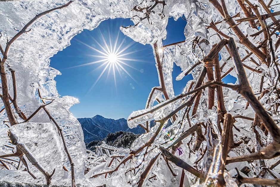
"Twinkle, Twinkle Little Star" by Rossi Fang
Photo location: Taiwan, Province Of China
Camera: Sony A7RIII
On the most beautiful mountain in Taiwan, Rossi captured this photo of the warm sun melting the frozen mountain world of the night before. "The crystal clear ice gleams with the sunlight this morning, making the entire alpine world warm".
Ice is simply water in a solid form, which occurs in the atmosphere and on the Earth's surface when the temperature falls below 0°C. It can take many forms, such as snow, hoar frost, rime, glaze, hail and ice pellets.
Glaze is a smooth, transparent type of ice that forms when drizzle or rain hits a cold surface and freezes on contact. It can be created when rain or drizzle is at a sub-zero temperature but remains in liquid form, known as supercooled water, meets the ground or when non-supercooled rain or drizzle meets a surface temperature below 0ºC. It can be dangerous to motorists and pedestrians as it is transparent, and the roads and pavements appear wet. It can also be damaging when it gains sufficient thickness as the extra weight can bring down tree branches.

"Frost Winter Sunrise over the Gwda River" by Krzysztof Tollas
Photo location: Pila, Poland
Camera: Nikon D750 with Nikkor AF 70-300 mm
Krzysztof captured a frosty and picturesque sunrise over the Gwda River in Poland.
Hoar frost is the most common type of frost and occurs on clear winter nights when the surface temperature falls below 0ºC, and there is enough moisture in the air for a frost to form. Hoar frost is composed of tiny ice particles formed by the same process as dew, but when the surface temperature is below freezing.
The 'feathery' variety of hoar frost initially forms when the surface temperature falls below freezing before dew begins to form. Ice crystals start to form as water vapour suspended in the air freezes on contact with the surface – this process is known as deposition. The 'white' frost, composed of more globular ice, forms when dew forms first on a surface and the temperature falls below 0ºC.
There are a few other types of frost, including ground frost, when the ground temperature falls to or below freezing, but the air temperature may remain above freezing. For an air frost to occur, the air temperature must drop to, or below, freezing at the height of at least one metre above the ground.

"Departing Storm over Bembridge Lifeboat Station" by Jamie Russel
Photo location: Bembridge, Isle of Wight, UK
Camera: Nikon D7500 with Sigma 10-20 lens.
After chasing storms and showers west to east across the Isle of Wight to capture some incredible rainbows, Jamie reached Bembridge as the final shower left. "In a panic (he) waded into the waist-deep water, fully dressed, just to compose this scene".
Rainbows are optical phenomena that occur when sunlight shines through raindrops. The light is refracted as it enters the raindrop, then reflected off the back of the droplet and then refracted again as it exits and travels towards our eyes. This causes the sunlight to split into different colours. The sun needs to be behind the viewer and needs to be low in the sky. The lower the sun in the sky, the more of an arc of a rainbow the viewer will see. Also, the rain, fog, or other source of water droplets, must be in front of the viewer. The angle at which the light is scattered is different for everyone, which means that every rainbow is unique to the observer.
Double rainbows form when sunlight is reflected twice within a raindrop. They are relatively common, especially when the sun is low in the sky, such as in the early morning and late afternoon. The second rainbow is fainter, and more 'pastel' in tone and a key feature of a double rainbow is that the colour sequence in the second rainbow is reversed.
Royal Meteorological Society
"Highway to Paradise" by Sara Jazbar
Photo location: Črni Kal, Slovenia
Camera: Nikon D500
Two or three times each year, Črni Kal, a small town in Slovenia, experiences a temperature inversion which places fog under the highway bridge. When Sara first arrived, there was a wall of fog, and the visibility was reduced to just a couple of metres. However, after waiting a few hours, this beautiful scene appeared. "The fog stopped under the bridge and lingered there, flowing, moving, as if alive".
Fog is a low cloud that forms at the surface. The relative humidity is above 95%, and visibility is reduced to less than 1,000 metres. Fog is caused by tiny water droplets suspended in the air, and there are a few different types of fog: radiation fog, valley fog, advection fog, hill fog and evaporation fog.
In the troposphere, the lower part of the atmosphere where most of our weather happens, the temperature typically decreases with height. However, sometimes a smaller layer can form where the temperature increases with height; this layer is called a temperature inversion. Inversions usually happen in areas of high pressure, where the air descends towards the ground, and as it falls, it dries out and warms up. This warm layer of air can act as a lid and trap the cooler air, low clouds, and fog near the surface.
"Peaceful" by Zhenhuan Zhou
Photo location: Ontario, Canada
Camera: Canon EOS 5D Mark IV
In early February 2022, southern Ontario was hit by the worst snowfall in decades. Zhenhuan captured this photo of a horse farm, which was turned into a winter wonderland by the snowstorm. "It looks so peaceful".
Snow forms when tiny ice crystals in clouds stick together to become snowflakes. If enough crystals stick together, they will become heavy enough to fall to the ground. Snowflakes that fall through moist air slightly warmer than 0ºC will melt around the edges and stick together to produce big flakes. This creates 'wet' snow, which is good for making snowmen and snowballs. Whereas snowflakes that fall through dry, cold air produce powdery snow that does not stick together. This creates 'dry' snow, which is ideal for snow sports but is more likely to drift when it is windy.
"Circle of Wheat" by Laura Hedien
Camera: iPhone 13 Pro
Photo location: Russell Kansas, USA
In late June 2022, Laura was in Kansas and captured this photo of a supercell with golden wheat fields in the foreground. "There is nothing like the feeling of standing before something so massive and potentially destructive but yet so incredibly majestic and beautiful. To even have a slight understanding of a supercell's birth, maturity and finally death is humbling".
Supercells are potentially the most dangerous type of convective storm clouds. They tend to produce severe weather, including damaging winds, huge hail, flash flooding and sometimes tornadoes. Supercells are unique from other thunderstorms because they have a deep and persistent rotating updraft called a mesocyclone. If the environment is favourable, supercell thunderstorms can last for several hours.
"Twinkle, Twinkle Little Star" by Rossi Fang
Photo location: Taiwan, Province Of China
Camera: Sony A7RIII
On the most beautiful mountain in Taiwan, Rossi captured this photo of the warm sun melting the frozen mountain world of the night before. "The crystal clear ice gleams with the sunlight this morning, making the entire alpine world warm".
Ice is simply water in a solid form, which occurs in the atmosphere and on the Earth's surface when the temperature falls below 0°C. It can take many forms, such as snow, hoar frost, rime, glaze, hail and ice pellets.
Glaze is a smooth, transparent type of ice that forms when drizzle or rain hits a cold surface and freezes on contact. It can be created when rain or drizzle is at a sub-zero temperature but remains in liquid form, known as supercooled water, meets the ground or when non-supercooled rain or drizzle meets a surface temperature below 0ºC. It can be dangerous to motorists and pedestrians as it is transparent, and the roads and pavements appear wet. It can also be damaging when it gains sufficient thickness as the extra weight can bring down tree branches.
"Frost Winter Sunrise over the Gwda River" by Krzysztof Tollas
Photo location: Pila, Poland
Camera: Nikon D750 with Nikkor AF 70-300 mm
Krzysztof captured a frosty and picturesque sunrise over the Gwda River in Poland.
Hoar frost is the most common type of frost and occurs on clear winter nights when the surface temperature falls below 0ºC, and there is enough moisture in the air for a frost to form. Hoar frost is composed of tiny ice particles formed by the same process as dew, but when the surface temperature is below freezing.
The 'feathery' variety of hoar frost initially forms when the surface temperature falls below freezing before dew begins to form. Ice crystals start to form as water vapour suspended in the air freezes on contact with the surface – this process is known as deposition. The 'white' frost, composed of more globular ice, forms when dew forms first on a surface and the temperature falls below 0ºC.
There are a few other types of frost, including ground frost, when the ground temperature falls to or below freezing, but the air temperature may remain above freezing. For an air frost to occur, the air temperature must drop to, or below, freezing at the height of at least one metre above the ground.
"Departing Storm over Bembridge Lifeboat Station" by Jamie Russel
Photo location: Bembridge, Isle of Wight, UK
Camera: Nikon D7500 with Sigma 10-20 lens.
After chasing storms and showers west to east across the Isle of Wight to capture some incredible rainbows, Jamie reached Bembridge as the final shower left. "In a panic (he) waded into the waist-deep water, fully dressed, just to compose this scene".
Rainbows are optical phenomena that occur when sunlight shines through raindrops. The light is refracted as it enters the raindrop, then reflected off the back of the droplet and then refracted again as it exits and travels towards our eyes. This causes the sunlight to split into different colours. The sun needs to be behind the viewer and needs to be low in the sky. The lower the sun in the sky, the more of an arc of a rainbow the viewer will see. Also, the rain, fog, or other source of water droplets, must be in front of the viewer. The angle at which the light is scattered is different for everyone, which means that every rainbow is unique to the observer.
Double rainbows form when sunlight is reflected twice within a raindrop. They are relatively common, especially when the sun is low in the sky, such as in the early morning and late afternoon. The second rainbow is fainter, and more 'pastel' in tone and a key feature of a double rainbow is that the colour sequence in the second rainbow is reversed.
PERLOU
The Living Force
https://twitter.com/Loovenelle
PERSONNEL
https://twitter.com/Loovenelle
@Loovenelle
L'arbre tordu vit sa vie alors que l'arbre droit fini en planches". Proverbe chinois.
L'arbre tordu vit sa vie tandis que l'arbre droit finit en planches". Proverbe chinois.

PERSONNEL
https://twitter.com/Loovenelle
@Loovenelle
L'arbre tordu vit sa vie alors que l'arbre droit fini en planches". Proverbe chinois.
L'arbre tordu vit sa vie tandis que l'arbre droit finit en planches". Proverbe chinois.