This is fascinating! The shock wave was even registered in Croatia!
Believe it or not, but the meteorological stations in Istria tonight clearly recorded the shock wave of a volcanic eruption in Tonga !
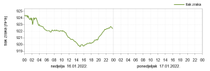
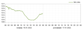
Between 20:50 and 21:00, the measuring locations recorded oscillations of air pressure in the range of 1 to 3 hPa, and the graphical representation of its movement is impressive.
Below you can see what the arrival of the weight wave looked like at the stations in Peroj, Poreč and Belci near Pazin, with the attached archive of meteorological data. Similar values were measured by other stations.
The eruption of the volcano in Tonga happened at 5:10 our time, so the shock wave traveled to us for about 15 hours, and at that time it covered more than 17,000 km! Fascinating. (PR / IM).

Oscillation of air pressure in Peroj, source: Istramet

This evenings oscillations of air pressure in Peroj, source: Istramet

Air pressure in Belci near Pazin, source: Istramet

Air pressure trends in Poreč, source: Istramet
The shock wave of the eruption on Tonga traveled 17,000 km and reached Istria, our stations recorded it!
Published: January 15, 2022 at 10:23 p.m.Believe it or not, but the meteorological stations in Istria tonight clearly recorded the shock wave of a volcanic eruption in Tonga !
Between 20:50 and 21:00, the measuring locations recorded oscillations of air pressure in the range of 1 to 3 hPa, and the graphical representation of its movement is impressive.
Below you can see what the arrival of the weight wave looked like at the stations in Peroj, Poreč and Belci near Pazin, with the attached archive of meteorological data. Similar values were measured by other stations.
The eruption of the volcano in Tonga happened at 5:10 our time, so the shock wave traveled to us for about 15 hours, and at that time it covered more than 17,000 km! Fascinating. (PR / IM).
Oscillation of air pressure in Peroj, source: Istramet
This evenings oscillations of air pressure in Peroj, source: Istramet
Air pressure in Belci near Pazin, source: Istramet
Air pressure trends in Poreč, source: Istramet


 Vulkane.net