Major Eruption of Undersea Volcano in Tonga

This is fascinating! The shock wave was even registered in Croatia!

The shock wave of the eruption on Tonga traveled 17,000 km and reached Istria, our stations recorded it!​

Published: January 15, 2022 at 10:23 p.m.

Believe it or not, but the meteorological stations in Istria tonight clearly recorded the shock wave of a volcanic eruption in Tonga !

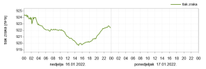
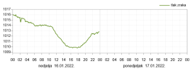
Between 20:50 and 21:00, the measuring locations recorded oscillations of air pressure in the range of 1 to 3 hPa, and the graphical representation of its movement is impressive.

Below you can see what the arrival of the weight wave looked like at the stations in Peroj, Poreč and Belci near Pazin, with the attached archive of meteorological data. Similar values were measured by other stations.

The eruption of the volcano in Tonga happened at 5:10 our time, so the shock wave traveled to us for about 15 hours, and at that time it covered more than 17,000 km! Fascinating. (PR / IM).

tlakperoj1.jpg


Oscillation of air pressure in Peroj, source: Istramet


peroj3.jpg


This evenings oscillations of air pressure in Peroj, source: Istramet

tlakbelci.jpg


Air pressure in Belci near Pazin, source: Istramet

porec1.jpg


Air pressure trends in Poreč, source: Istramet
 
Also in Baltic regions:

A giant volcano erupts in the Pacific Ocean and a shock wave is felt in the Baltic region

A giant volcano erupted Saturday in the Pacific Ocean near Tonga. Its vibrational wave is also felt in the Baltic region.

“The shock wave caused by the eruption of the giant volcano near Tonga has also been detected in our region. The barometer at the University of Dortmund recorded the tab” Atmospheric pressure just minutes after 9 pm Latvian time, “said Martin.

The epicenter was reported below the Pacific Ocean floor, however; no tsunami alert was issued.


Shockwave from volcanic eruption near Tonga reaches the Netherlands


A unique measurement, that’s what meteorologist Wouter van Bernebeek calls the observation. “This pressure wave has already covered a distance of more than 17,000 km!” Fellow meteorologist Wilfred Janssen from Weerplaza: “How special to see this!”

It involves a rapid rise and now a fall in air pressure. The so-called pressure wave was not felt, we hardly notice it, but it was measurable with a barometer. “The amplitude was ultimately 3 hPa, considerably higher than expected!” says Van Bernebeek. “It shows how incredibly powerful that bang must have been this morning…” The air pressure has now returned to its old level.
 
Here is another graph from Berlin. It has the dent around 21:00, and also the other dent around 03:00 this morning. I could imagine that the second disturbance is the wave coming from the other direction on the globe, which would mean it made it around the whole globe. Europe isn't far from the antipode of Hunga Tonga Island in the south of Algerie. (antipode map, enter 'hunga tonga')
Screenshot_2022-01-16_15-17-09.png


...this site has some videos where you can see the shock wave traveling around the globe. The shock wave is also visible in the satellite images:
 
An interesting video analyzing the current and previous eruptions of Hunga Tonga, the recent quakes in its vicinity, the induced tsunami, the composition of height of the ash cloud..
They say in the video, the plume went to 16,800 m. others said 60,000 feet (ca. 18 km), 63,000 feet (ca. 19 km). One video mentioned a VEI 4. From the Wiki about the Volcanic Explosivity Index, one can learn that a VEI 5 is corresponds to a plume from 10 km to 20 km, and an ejected volume in the order of 1-10 km^3. For a VEI 4 the numbers are a plume more than 10 km high, and an ejecta volume of 0.1 -1 km^3. While the ejecta often is solid, in this case there must have been a lot of water too.

One question regarding the unusually high altitude reaching plume is if the large amount of steam aided the cloud to reach higher up. One reason would be that moist air is lighter than dry air as the molar mass of water, H2O, is 18 grams per mol, while it for the main component, Nitrogen, N2, is about 28 grams per mol, and for Oxygen, O2 is 32 grams per mol.
Furthermore when the moist air condenses, the water vapor no longer contributes to the air pressure, so the overall pressure drops. While I don't understand all the details of the following paper from the University of St. Petersburg in Russia, they say this condensation can lead to increased updraft in certain cases.
The paper and its abstract:
Potential energy of atmospheric water vapor and the air motions induced by water vapor condensation on different spatial scales A. M. Makarieva1 and V. G. Gorshkov1 March 29, 2010 Abstract Basic physical principles are considered that are responsible for the origin of dynamic air flow upon condensation of water vapor, the partial pressure of which represents a store of potential energy in the atmosphere of Earth. Quantitative characteristics of such flow are presented for several spatial scales. It is shown that maximum condensation-induced velocities reach 160 m s−1 and are realized in compact circulation patterns like tornadoes.
160 m/s is about 9,600 m per minute, so that is very fast, even if such a speed would not be sustained for long.

The paper explains:
Any fluctuation leading to an upward displacement of an air volume results in adiabatic cooling of the rising air. Air temperature drops such that the equilibrium water vapor concentration dictated by Boltzmann’s distribution becomes oversaturated at all heights where the air ascends. This causes the water vapor to condense. Its concentration decreases down to the saturated concentration. Condensation diminishes the total air pressure and disturbs Boltzmann’s distribution of moist air. The vertical gradient of air pressure becomes greater than the weight of a unit air volume. There appears an upward-directed force acting on a unit air volume. Static equilibrium of moist air in the gravitational field is no longer possible. There appears a rising flow of air masses induced by condensation. The process of condensation is sustained by continuous evaporation of water vapor from the hydrosphere. The upward-directed force that acts on moist air causing it to rise adiabatically was termed the evaporative-condensational force (Gorshkov and Makarieva, 2006; Makarieva and Gorshkov, 2007, 2009a).
While this can help to explain that the plume reached very high, we will have to wait as to why the geologists would think this latest eruption from Hunga Tonga–Hunga Haʻapai should be labled as VEI 4.

A VEI 4 occurs about every 18 months while a VEI 5 every 12 years. The last VEI 4 was Taal in 2020 and the last VEI 5 was Puyehue in 2011.
 
Last edited:
My Ruapehu has had some unusual underlying tectonic plate activity although the eruption alert level remains low.
From 30 December 2021, we have recorded a sequence of tectonic earthquakes located beneath Ruapehu’s summit area. So far, there have been at least 30 distinct earthquakes in this sequence. When compared to historical records, the number of earthquakes with epicentres closely confined to the summit area, is unusual. While these earthquake clusters are uncommon, none of our monitoring data suggests that the volcano is exhibiting increased levels of activity.
 
Hunga-Tonga Ha’apai Volcano, Tonga - Pacific Ocean
16 Jan 2021

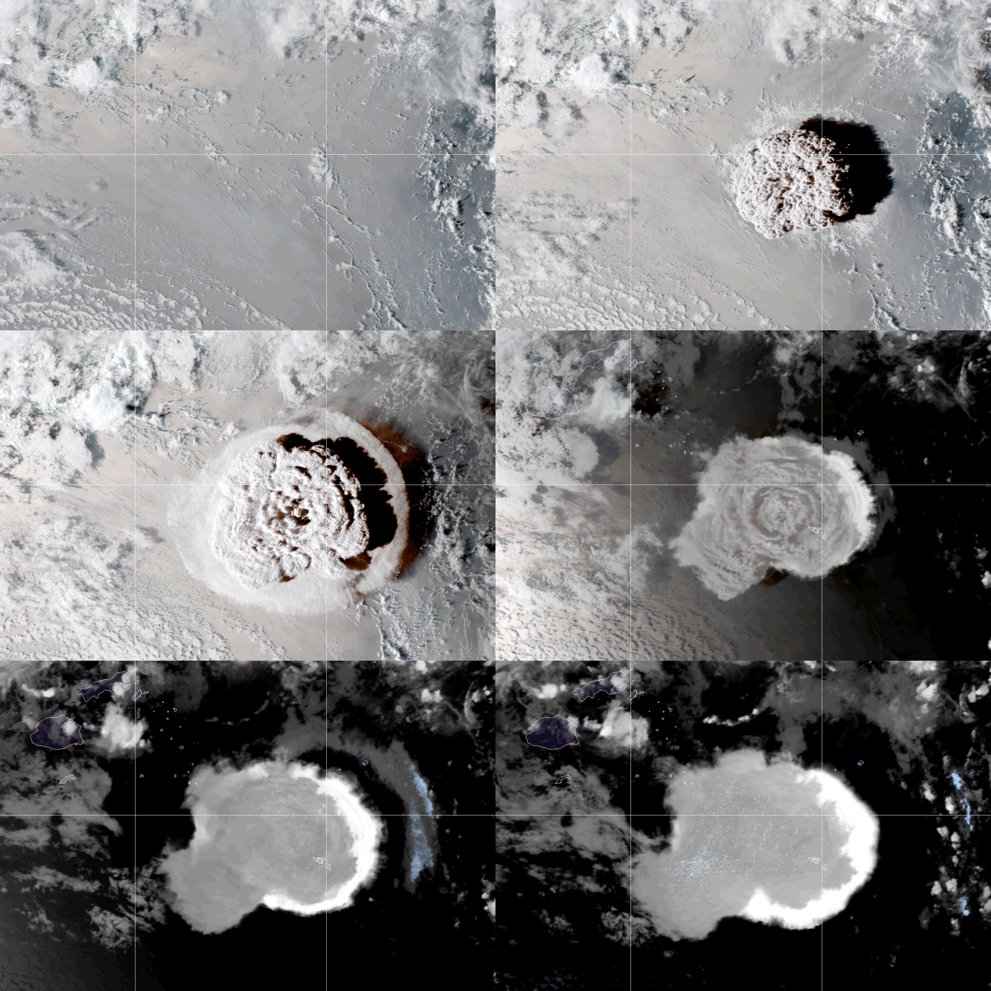
A littler later than I had planned, here are the images before and after the major eruption. But instead, I found even higher resolution images later during the day showing more details (the ones i had first in mind, were just small fuzzy ones)

1.JPG

2.jpg

3.jpg
 
Hunga-Tonga Ha’apai Volcano, Tonga - Pacific Ocean
16 Jan 2021

In a german Vulkane.net connected Facebook thread about volcanoes, following emerged, given a little bit more details about the anatomy of the Caldera volcano.

4.jpg

One person there wrote:
So many of you have been asking what could have happened to generate a massive eruption and tsunami in Tonga. There are many unknowns at this stage, but one theory is this:

1) The caldera of the volcano sits just to the south of the (now destroyed) Island. It falls off very steeply in this area (confirmed with Sonar when we were there). Think of it as a very large underwater cliff face.

2) During the eruptions that commenced in late December, the island expanded significantly. Most of the new land was added in this southern section, which made it highly unstable (due to the caldera cliff face)

3) On Jan 14, a small collapse occurred which was responsible for the small tsunami. This made the mass even more unstable, eventually giving way and collapsing into the ocean (and generating the tsunami).

4) This collapse exposed the conduit of the volcano and large quantities of magma were exposed to the ocean, creating the massive plume.

The huge explosive power can't be explained by just magma-water interaction alone. There is a possibility that this could have been a caldera eruption also. This happens approximately ever 1000 years.

5.JPG


Huge amounts of lightning strikes detected

Negative: 57186
Positive: 16088

Cloud: 118035

6.jpg 7.jpg


Global Ripple Effect

Below you can see the worldwide ripple traversing around the entire globe. In the late evening of 15 January 2022, the European and German station noted anomalies swinging on their barometers with up to 2.5 hPa.


Peru reports two deaths

as the tsunami reached the shores of South America. Supposedly Peru did not alert to a Tsunami, only for abnormal high waves. The rumor says the victims were two divers, but I have not dug deeper into that story.


Reuters writes via Swissinfo.ch:
January 16, 2022 - 15:58

LIMA (Reuters) - Two people drowned off a beach in northern Peru, the local civil defense authority reported on Sunday, after unusually high waves were recorded in several coastal areas following Saturday's eruption of an underwater volcano in Tonga in the Pacific Ocean.

The death of two people by drowning occurred on Saturday on a beach located in the Lambayeque region, Peru's National Institute of Civil Defense (Indeci) said in a statement.

The underwater volcano off Tonga erupted on Saturday, prompting tsunami warnings and evacuation orders in Japan and causing huge waves on several South Pacific islands, where images on social media show waves crashing against homes on the shores.

More than 20 Peruvian ports were temporarily closed as a precautionary measure amid warnings that the volcano was causing abnormally high waves, Indeci said.

The Peruvian police said on Twitter that the two victims were found dead by officers from a Naylamp beach police station. The tweet said "the waves were abnormal" in the area and that it had been declared unsuitable for bathers. TV images showed several homes and businesses flooded by seawater in coastal areas in northern and central Peru. The Peruvian Navy had reported that a tsunami alert was ruled out for the Pacific Coast country.

In Japan, hundreds of thousands of people were advised to evacuate on Sunday as waves of more than a meter hit coastal areas, public broadcaster NHK reported. The footage on social media showed large waves crashing into coastal homes in several South Pacific islands.

(Reporting by Marco Aquino, writing by Hugh Bronstein. Editing by Jane Merriman)

🇩🇪 Vulkane.net writes about Hunga Tonga-Hunga Ha'Apai Volcano

HUNGA TONGA-HUNGA HA'APAI: THE BIRTH OF AN ISLAND

The young volcanic island of Hunga Tonga-Hunga Ha'apai saw the light of day in December 2014. Her birth was not a quiet one, but took place under tremendous labour pains. Surtseyan eruptions created a shallow sandbank that enclosed a crater and connected 2 rocky islets. The rocky islets were the overseas parts of a submarine caldera. They were called Hunga Tonga and Hunga Ha'apai. Due to the eruption of 2014, they grew together and the total island is called Hunga Tonga-Hunga Ha'apai. The submarine caldera has thus been partially filled in and the volcanic island forms the top of a powerful volcano that until now has operated largely in hiding.

Hunga Tonga and Hunga Ha'apai were both about 2 km long and a strait just as long separated them. A shoal about 3 km south of the rocky islands marks an ancient crater in the system. The 2014 eruption, however, manifested closer to the caldera rim and did not originate from the old crater.

Since the 20th century, 4 other eruptions of Hunga Tonga-Hunga Ha'apai have become known. They occurred in 1912, 1937, 1988 and 2009. The 1988 eruption had a VEI of 0 and probably lasted only a few hours. The other eruptions, including the 2014 eruption brought it to a VEI of 2. During the 2009 eruption, a temporary island already appeared. A 6th eruption began in early 2022.

DeepL
 
This is fascinating! The shock wave was even registered in Croatia!

The shock wave of the eruption on Tonga traveled 17,000 km and reached Istria, our stations recorded it!​

Published: January 15, 2022 at 10:23 p.m.

Believe it or not, but the meteorological stations in Istria tonight clearly recorded the shock wave of a volcanic eruption in Tonga !

Between 20:50 and 21:00, the measuring locations recorded oscillations of air pressure in the range of 1 to 3 hPa, and the graphical representation of its movement is impressive.

Below you can see what the arrival of the weight wave looked like at the stations in Peroj, Poreč and Belci near Pazin, with the attached archive of meteorological data. Similar values were measured by other stations.

The eruption of the volcano in Tonga happened at 5:10 our time, so the shock wave traveled to us for about 15 hours, and at that time it covered more than 17,000 km! Fascinating. (PR / IM).

tlakperoj1.jpg


Oscillation of air pressure in Peroj, source: Istramet


peroj3.jpg


This evenings oscillations of air pressure in Peroj, source: Istramet

tlakbelci.jpg


Air pressure in Belci near Pazin, source: Istramet

porec1.jpg


Air pressure trends in Poreč, source: Istramet

The disturbance in air pressure can be seen throughout all the automatic stations along Adriatic, together with 2nd dip @mrtn mentioned (but around 2 AM in Croatia, instead of 3 AM in Berlin).

Below are screenshots of air pressure measurements from automatic stations (AS), going from Northern to Southern Adriatic.

AS Opatija (Northern Kvarner Bay)
AS_Opatija.png
AS Rijeka (Northern Kvarner Bay)
AS_Rijeka.png
AS Crikvenica (Northern Kvarner Bay)
AS_Crikvenica.png
AS Malinska (island of Krk)
AS_Malinska.png
AS Sv. Ivan na pučini, svjetionik (a rock near Rovinj, Istria)
AS_SvIvan-svjetionik.png
AS Senj (Middle Kvarner Bay, under Velebit mountain)
AS_Senj.png
AS Rab (Middle Kvarner Bay, island of Rab)
AS_Rab.png
AS Porer (lighthouse near Pula, Istria)
AS_Porer.png
AS Mali Lošinj (Southern Kvarner Bay, island of Mali Lošinj)
AS_MaliLosinj.png
AS Zadar (Northern Dalmatia)
AS_Zadar.png
AS Šibenik (Middle Dalmatia)
AS_Sibenik.png
AS Split (Middle Dalmatia)
AS_Split.png
AS Makarska (Middle Dalmatia)
AS_Makarska.png
AS Ploče (Southern Dalmatia)
AS_Ploce.png
AS Lastovo (island of Lastovo, Southern Adriatic)
AS_Lastovo.png
AS Dubrovnik (Southern Adriatic)
AS_Dubrovnik.png
AS Prevlaka (Southern Adriatic, border with Monte Negro)
AS_Prevlaka.png
The disturbance was also felt inland, in Zagreb and other places (Čabar, Sisak, Osijek), though less pronounced on the charts.

AS Zagreb
AS_Zagreb.png

I'm intrigued and curious about the 2nd disturbance; 1st arrived at the more or less similar time (around 9 PM) through all the Europe, but 2nd one was more than 1h out of phase comparing Croatia (2 AM) and Berlin (3 AM), and the shape looks almost as the 1st one was reflected on something. :huh:
 

Attachments

  • AS_Cabar.png
    AS_Cabar.png
    31 KB · Views: 4
  • AS_Sisak.png
    AS_Sisak.png
    31.3 KB · Views: 3
They say in the video, the plume went to 16,800 m. others said 60,000 feet (ca. 18 km), 63,000 feet (ca. 19 km). One video mentioned a VEI 4. From the Wiki about the Volcanic Explosivity Index, one can learn that a VEI 5 is corresponds to a plume from 10 km to 20 km, and an ejected volume in the order of 1-10 km^3. For a VEI 4 the numbers are a plume more than 10 km high, and an ejecta volume of 0.1 -1 km^3. While the ejecta often is solid, in this case there must have been a lot of water too.

One question regarding the unusually high altitude reaching plume is if the large amount of steam aided the cloud to reach higher up. One reason would be that moist air is lighter than dry air as the molar mass of water, H2O, is 18 grams per mol, while it for the main component, Nitrogen, N2, is about 28 grams per mol, and for Oxygen, O2 is 32 grams per mol.
Furthermore when the moist air condenses, the water vapor no longer contributes to the air pressure, so the overall pressure drops. While I don't understand all the details of the following paper from the University of St. Petersburg in Russia, they say this condensation can lead to increased updraft in certain cases.
The paper and its abstract:

160 m/s is about 9,600 m per minute, so that is very fast, even if such a speed would not be sustained for long.

The paper explains:

While this can help to explain that the plume reached very high, we will have to wait as to why the geologists would think this latest eruption from Hunga Tonga–Hunga Haʻapai should be labled as VEI 4.

A VEI 4 occurs about every 18 months while a VEI 5 every 12 years. The last VEI 4 was Taal in 2020 and the last VEI 5 was Puyehue in 2011.
That's interesting, but while this eruption may have a 'low/normal VEI', it has properties that, in combination, are unusual:

A mushroom cloud, 300kms in diameter, sustaining its shape for many hours; the extent of lightning within that debris cloud; the powerful shockwave(s) (which could - allegedly - be heard in Alaska - 9,000kms away!); a tsunami reaching everywhere from Japan around to Peru (where two people drowned); globally recorded air pressure changes; and probably much more!

So, if this was something "unlike anything we've ever before witnessed via satellite imagery," as I've seen a number of people claim on social media, then how just unusual/rare/novel was it?!
 
Last edited:
I'm intrigued and curious about the 2nd disturbance; 1st arrived at the more or less similar time (around 9 PM) through all the Europe, but 2nd one was more than 1h out of phase comparing Croatia (2 AM) and Berlin (3 AM), and the shape looks almost as the 1st one was reflected on something.
I haven't seen how it travelled through Europe or where it came from. Shortest path would be from north over the Arctic I think. If the first came from east or north-east it would reach Germany and Croatia at a similar time. If the second came from south-east it could explain why it would reach Germany later.
 
That's interesting, but while this eruption may have a 'low/normal VEI', it has properties that, in combination, are unusual:
It is and the commentators are catching up. There is now a Wiki for this explosion. RNZ in New Zealand, 2000 km south of Tonga has a couple of articles:

Tonga eruption likely the world's largest in 30 years - scientist
8:05 am on 17 January 2022
Early data from Tonga's violent volcanic eruption suggests it is the biggest since Mount Pinatubo in the Philippines 30 years ago, volcanologist Shane Cronin says.
[...]
"The large and explosive lateral spread of the eruption suggests that it was probably the biggest one since about the 1991 eruption of Pinatubo," Cronin said.
[...]
Volcanologist Professor Shane Cronin of the University of Auckland. Photo: Supplied/ University of Auckland
He said early data suggested the eruption could measure as high as five on the volcanic explosivity index (VEI).

The index estimates the strength and potential impact of an eruption on an eight-point scale, with each successive interval representing a tenfold increase in energy.

Cronin said a VEI-5 eruption would happen once or twice in a decade globally.

Tonga eruption could have 'cooling effect' on southern hemisphere - scientist
7:47 pm on 17 January 2022
[...]
Climate scientist Jim Salinger has researched the impacts of major volcanic eruptions, including Pinatubo, on the climate in New Zealand.

He said it was not nearly as large eruption as Pinatubo, and would not have a global impact on the climate, but there could be some local effects in the Southern Hemisphere.

Dr Salinger said it could take a few months to kick in and have cooling of about 0.1 to 0.5 degrees, lasting until spring.


"[In] New Zealand it would mean that it might be just a little bit cooler than normal."

He said it would be nothing like after the Pinatubo eruption in 1991, when there were some "very cold and horrible winters".

But one upshot, there could be some wonderful sunsets.

"You get a lot of purple sunsets," Dr Salinger said.

"And as the material drifts down even lower it eventually falls out, but you get some fabulous purple skies."
For a map of the area and the distance to New Zealand, here is a screenshot:
Screenshot 2022-01-17 142108.png
 
Back
Top Bottom