Earthquakes around the world

WORLDWIDE EARTHQUAKE REPORT MARCH 06/2023

●M 5.8 - Fiji region
2023-03-06 20:59:59 (UTC)
20.782°S 178.300°W. 526.4 km depth
USGS earthquake alert
chrome_screenshot_1678151837674.png

●M 5.1 - 72 km SSE of Kushiro, Japan
2023-03-06 22:24:48 (UTC)
42.333°N 144.556°E. 47.6 km depth
USGS earthquake alert

●M 5.0 - 49 km NW of Coquimbo, Chile
2023-03-06 07:34:49 (UTC)
29.600°S 71.659°W. 35.0 km depth
USGS earthquake alert

●M 5.0 - Scotia Sea
2023-03-06 09:25:49 (UTC)
60.929°S 33.416°W. 10.0 km depth
USGS earthquake alert
This region of the South Atlantic Ocean has registered strong earthquakes in the last few days. This region of the South Atlantic Ocean has recorded strong earthquakes in the last few days. Previously, an M5.2 and an M5.6 earthquake were recorded in the region of the Sandwich Islands. These earthquakes occurred between the Scotia plate and the South American plate which is part of the Atlantic ridge.
chrome_screenshot_1678150551902.png

Nicaragua was shaken by two moderate earthquakes within ten minutes of each other. These earthquakes are the result of the collision of the Caribbean Plate and the Cocos Plate in the Mexican Pacific.

●M 4.7 - 96 km SW of Jiquilillo, Nicaragua
2023-03-06 20:22:00 (UTC)
12.086°N 88.025°W. 43.3 km depth
USGS earthquake alert

●M 4.5 - 81 km SW of Jiquilillo, Nicaragua
2023-03-06 20:32:01 (UTC)
12.192°N 87.949°W. 43.9 km depth
USGS earthquake alert

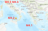
Moderate earthquakes were also recorded along the Mexican Pacific coast. According to SSN

●M4.3 Mar-07 00:01:30 UTC, 14 km to NE of las Guacamayas Michoacan Depth:14.6km

●M4.1 Mar-06 10:45:31 UTC, 15 km to W of CD Ixtepec Oaxaca, Depth:66.7km

●M4.0 Mar-06 08:45:31 UTC, 64 km to SW of Ometepec, Guerrero, Depth:16.5km,

●M4.0 Mar-06 07:57:26 UTC, off the coast of Chiapas, Mexico, Depth:16.0km,

●M4.0 Mar-06 05:21:27 UTC, Oaxaca Mexico Depth 14.0km

●M4.2 Mar-06 03:45:31 UTC, 62 km to SE of Salina Cruz Oaxaca, Depth 22.0km

These earthquakes can be considered as "normal" in the region.

● Summary

Seismic activity level has been at moderate levels in the last 24 hours. This is the last chart posted by Volcanodiscovery at 01:10 UTC on March 07 Global seismic activity chart
~4 quakes above magnitude 5
~41 quakes between magnitude 4 and 5
~111 quakes between magnitude 3 and 4
~373 quakes between magnitude 2 and 3
~592 quakes below magnitude 2 that people normally don't feel.
~1121 earthquakes in the past 24h (1004 earthquakes in the 24 hours prior to this report) Estimated combined seismic energy release: 12225 tons of TNT or 0.8 atomic bombs
Volcanodiscovery earthquake report 24h
 
M 6.0 - 4 km SE of San Mariano, Philippines
2023-03-07 06:02:34 (UTC)
7.472°N 126.027°E. 38.6 km depth
USGS earthquake alert

Data for the same earthquake reported by different agencies

Mag.DepthLocationSource
6.039 km4 Km SE of San Mariano, PhilippinesUSGS
6.039 kmMindanao, PhilippinesRaspberry
Shake
5.710 kmPhilippines: Near DavaoRENASS
5.910 kmPhilippines: 013 Km N 16° W of Maragusan (Davao De Oro)PHIVOLCS
5.810.2 kmPhilippines [Land]INGV
5.910 kmMindanao, PhilippinesGFZ
6.027 kmMindanao, PhilippinesGeoAu
6.010 kmMindanao, PhilippinesIRIS
5.910 kmPhilippines: 菲律宾棉兰老岛CEIC
6.010 kmMINDANAO, PHILIPPINESEMSC
 
Very strong mag. 6.0 earthquake - Bismarck Sea, 73 km south of Kavieng, New Ireland, Papua New Guinea, on Tuesday, Mar 7, 2023 at 11:51 pm

The second major earthquake recorded this day.

M 6.0 - 72 km SSW of Kavieng, Papua New Guinea
2023-03-07 13:51:49 (UTC)
3.213°S 150.647°E. 10.0 km depth
USGS earthquake alert

Data for the same earthquake reported by different agencies

Mag.DepthLocationSource
6.010 km72 Km SSW of Kavieng, Papua New GuineaUSGS
6.010 kmPapua New Guinea: New Ireland Region, P.N.G.Raspberry
Shake
5.410 kmPapua New Guinea: Near LaeRENASS
5.910.2 kmPapua New Guinea [Sea]INGV
6.010 kmNew Ireland Region, Papua New GuineaGFZ
5.930 kmPapua New Guinea: NEW IRELAND REGION, P.N.G.EMSC
6.025 kmPapua New Guinea: New Ireland Region, P.N.G.GeoAu
6.010 kmPapua New Guinea: New Ireland Region, P.N.G.IRIS
Volcanodiscovery
 
WORLDWIDE EARTHQUAKE REPORT MARCH 07/2023

Most of the earthquakes larger than M5.0 occurred in Southeast Asia including two M6.0 earthquakes.

chrome_screenshot_1678237747472.png

● M 5.6 - 9 km ENE of Bantacan, Philippines
2023-03-07 08:47:42 (UTC)
7.622°N 126.211°E. 10.0 km depth
USGS earthquake alert

● M 5.4 - 176 km S of Tomohon, Indonesia
2023-03-07 20:31:30 (UTC)
0.259°S 124.573°E. 54.9 km depth
USGS earthquake alert

● M 5.3 - 188 km SW of Bandar Lampung, Indonesia
2023-03-07 07:31:57 (UTC)
6.554°S 103.982°E. 43.3 km depth
USGS earthquake alert

● M 5.3 - 135 km SSW of Kokopo, Papua New Guinea
2023-03-07 20:46:05 (UTC)
5.468°S 151.778°E. 78.2 km depth

● M 5.0 - 47 km SW of Nuquí, Colombia
2023-03-07 03:59:39 (UTC)
5.379°N 77.535°W. 8.6 km depth
USGS earthquake alert

●Moderate magnitude 4.8 earthquake - Bay of Bengal, 194 km north of Port Blair, India, on Tuesday, Mar 7, 2023 at 5:41 pm (11:11 UTC)
Volcanodiscovery
The Andaman and Arakan subduction zones have not ruptured in a long time.

● Summary

Seismic activity level has been at moderate levels in the last 24 hours. This is the last chart posted by Volcanodiscovery at 01:10 UTC on March 08 Global seismic activity chart
~2 quakes above magnitude 6
~5 quakes between magnitude 5 and 6
~32 quakes between magnitude 4 and 5
~127 quakes between magnitude 3 and 4
~396 quakes between magnitude 2 and 3
~616 quakes below magnitude 2 that people normally don't feel.
~1178 earthquakes in the past 24h (1121 earthquakes in the 24 hours prior to this report) Estimated combined seismic energy release: 42491 tons of TNT or 2.7 atomic bombs.
Volcanodiscovery earthquake report 24h
 
WORLDWIDE EARTHQUAKE REPORT MARCH 08/2023

● M 5.8 - 61 km WSW of Panguna, Papua New Guinea
2023-03-08 07:33:09 (UTC)
6.522°S 154.964°E. 60.0 km depth
USGS earthquake alert
A magnitude 5.8 earthquake 74 km (46 mi) WSW of Arawa (pop: 40,300), Bougainville, Papua New Guinea. The earthquake occurred at a moderately shallow depth of 60 km beneath the epicenter early evening on Wednesday, March 8th, 2023, at 6:33 pm local time.
quakemap7446503.jpg

● M 5.6 - 111 km ESE of Severo-Kuril’sk, Russia
2023-03-08 06:03:36 (UTC)50.132°N 157.440°E36.2 km depth
USGS earthquake alert

● M 5.4 - 207 km NNE of Fais, Micronesia
2023-03-08 13:43:23 (UTC)11.407°N 141.439°E10.0 km depth
USGS earthquake alert

● M 5.3 - south of the Fiji Islands
2023-03-08 08:34:51 (UTC)
24.980°S 179.974°E. 495.2 km depth
USGS earthquake alert

● M 5.2 - 182 km SSE of Vilyuchinsk, Russia
2023-03-08 16:10:50 (UTC)
51.546°N 159.848°E. 10.0 km depth
USGS earthquake alert

● Earthquakes in the Mediterranean region. The earthquake in Italy occurred a considerable depth

M 4.2 - 25 km NNW of Malfa, Italy
2023-03-08 18:30:45 (UTC)
38.768°N 14.680°E. 286.3 km depth
USGS earthquake alert

M 4.1 - central Mediterranean Sea
2023-03-08 23:41:49 (UTC)
36.492°N 19.784°E. 39.7 km depth
USGS earthquake alert

chrome_screenshot_1678325379498.png

● Summary

Seismic activity level has been at moderate levels in the last 24 hours. This is the last chart posted by Volcanodiscovery at 01:10 UTC on March 08 Global seismic activity chart
~5 quakes above magnitude 5
~27 quakes between magnitude 4 and 5
~104 quakes between magnitude 3 and 4
~355 quakes between magnitude 2 and 3
~717 quakes below magnitude 2 that people normally don't feel.
~1208 earthquakes in the past 24h (1178 earthquakes in the 24 hours prior to this report) Estimated combined seismic energy release: 18199 tons of TNT or 1.1 atomic bombs.
Volcanodiscovery earthquake report 24h
 
Moderate earthquake in Italy

Earthquake detected in Umbria, Italy, this Thursday, March 09, 2023, reports the Euro-Mediterranean Seismological Center (EMSC).

A preliminary report by the RENASS (France) agency placed the earthquake at magnitude 5.1 and a later review concluded that it was a M5.0 earthquake, other agencies place it between 4.3 and 4.4. According to USGS the quake occurred at a shallow depth.

M 4.3 - 2 km SW of Umbertide, Italy
2023-03-09 15:05:40 (UTC)
43.286°N 12.314°E. 4.4 km depth
USGS earthquake alert

This earthquake adds to recent activity in the Mediterranean region.
chrome_screenshot_1678325379498.png
Data for the same earthquake reported by different agencies

Mag.DepthLocationSource
4.39.8 kmItaly: 5 Km E Umbertide (PG)INGV
4.410 kmCENTRAL ITALYEMSC
4.34.4 kmCentral ItalyRaspberry
Shake
4.410 kmCentral ItalyGFZ
5.10 kmItaly: Near Rome (outside of Network Interest)RENASS
4.410 kmItaly: Umbertide / ItalienZAMG
4.34.4 km2 Km SW of Umbertide, ItalyUSGS
4.310 kmCentral ItalyIRIS

The general motion of the Eurasian plate is south. The southern and eastern boundaries of the Eurasian plate are the most tectonically active. Along the southern border the Indian and Arabian plates are colliding with the Eurasian plate, and along the eastern border the Philippine Sea plate is being subducted.
 
And another one in Italy again, an hour ago.

Magnitudemb 4.7
RegionCENTRAL ITALY
Date time2023-03-09 19:08:07.2 UTC
Location43.35 N ; 12.34 E
Depth2 km
Distances27 km NNW of Perugia, Italy / pop: 120,000 / local time: 20:08:07.2 2023-03-09
5 km N of Umbertide, Italy / pop: 11,000 / local time: 20:08:07.2 2023-03-09

Same region, probably an aftershock of the previous earthquake. Both earthquakes at a shallow depth.


Data for the same earthquake reported by different agencies

Mag.DepthLocationSource
4.68.3 kmItaly: 6 Km E Umbertide (PG)INGV
4.610 kmCentral ItalyRaspberry
Shake
4.910 km4.9 CENTRAL ITALYEMSC
4.610 kmItaly: 723 Km NW From OthonoiNOA
4.610 kmCentral ItalyGFZ
Volcanodiscovery
 
WORLDWIDE EARTHQUAKE REPORT MARCH 09/2023

●M 5.1 - 185 km SSE of Vilyuchinsk, Russia
2023-03-09 02:06:51 (UTC)
51.525°N 159.867°E. 10.0 km depth
USGS earthquake alert
This region of Russia has recorded moderate to strong earthquakes in the last few days.

●M 5.1 - 89 km SSE of Panguna, Papua New Guinea
2023-03-09 17:48:44 (UTC)
7.059°S 155.815°E. 76.4 km depth
USGS earthquake alert

Three moderate and deep earthquakes shake southeastern Mexico. Due to its low impact and brief intensity, the seismic alarm was not sounded in Mexico City. So far, no damage or effects on residents or buildings have been reported.

These earthquakes are in addition to the more than five earthquakes detected in less than two days in Oaxaca, Guerrero and Chiapas.

●M 4.9 - 15 km SSW of Nueva Colombia, Mexico
2023-03-09 04:22:46 (UTC)
15.567°N 92.780°W. 123.2 km depth
USGS earthquake alert

●M 4.7 - 8 km ENE of Palomares, Mexico
2023-03-09 12:01:36 (UTC)
17.161°N 94.982°W. 106.4 km depth
USGS earthquake alert

●M 4.0 - 16 km S of El Ramal (Porvenir), Mexico
2023-03-09 05:00:34 (UTC)
15.717°N 92.942°W. 129.4 km depth
USGS earthquake alert
chrome_screenshot_1678408092814.png

SSGEOS detected the atmospheric fluctuation for the region, let's hope they are not foreshocks.

M 4.2 - off the coast of Oregon
2023-03-09 06:48:04 (UTC)
43.689°N 128.354°W. 10.0 km depth
USGS earthquake alert

The situation in Turkey
More than 13,000 aftershocks recorded in one month after #Turkey #earthquake and Syria
Frequency of aftershocks remains high with an average of 300 to 400 events per day.
Via @gmazet

● Earthquake Forecast updated 8 March 2023, 19:33 UTC. A convergence of critical planetary geometry around 2 and 5 March may result in large to very large seismic activity, possibly even a mega-thrust earthquake around 3-4 March and/or 6-7 March.

A lunar peak later on the 9th could trigger stronger seismic activity, most likely around the 11th.

MAGNITUDE PROBABILITY

updated 9 March 2023, 23:00 UTC

M 6.0-6.4M 6.5-6.9M 7.0-8.4M 8.5+
60%60%50%40%


● Summary

Seismic activity level has been at  low levels in the last 24 hours. This is the last chart posted by Volcanodiscovery at 01:10 UTC on March 10 Global seismic activity chart
~2 quakes above magnitude 5
~43 quakes between magnitude 4 and 5
~108 quakes between magnitude 3 and 4
~303 quakes between magnitude 2 and 3
~851 quakes below magnitude 2 that people normally don't feel.
~1307 earthquakes in the past 24h (1208 earthquakes in the 24 hours prior to this report) Estimated combined seismic energy release:4903 tons of TNT or 0.3 atomic bombs
Volcanodiscovery earthquake report 24h
 
WORLDWIDE EARTHQUAKE REPORT MARCH 10_2023

The seismic swarm in Adak, Aleutian Islands
Alaska has increased. The highest magnitude earthquake recorded was 4.6
M 2.5 - 101 km W of Adak, Alaska
M 2.5 - Andreanof Islands, Aleutian Islands, Alaska
M 2.9 - 49 km SE of Perryville, Alaska
M 3.0 - 100 km W of Adak, Alaska
M 2.8 - 101 km W of Adak, Alaska
M 3.2 - 100 km W of Adak, Alaska
M 2.7 - 101 km W of Adak, Alaska
M 2.5 - 100 km W of Adak, Alaska
M 2.6 - 101 km W of Adak, Alaska
M 2.8 - 101 km W of Adak, Alaska
M 3.1 - 101 km W of Adak, Alaska
M 2.5 - 103 km W of Adak, Alaska
M 2.5 - 94 km W of Adak, Alaska
M 2.5 - 104 km W of Adak, Alaska
M 2.8 - Andreanof Islands, Aleutian Islands, Alaska
M 3.3 - Andreanof Islands, Aleutian Islands, Alaska
M 2.6 - 101 km W of Adak, Alaska
M 2.9 - 100 km W of Adak, Alaska
M 2.8 - 94 km W of Adak, Alaska
M 4.0 - 101 km W of Adak, Alaska
M 4.1 - Andreanof Islands, Aleutian Islands, Alaska
M 3.0 - 100 km W of Adak, Alaska
M 2.9 - Andreanof Islands, Aleutian Islands, Alaska
M 2.6 - 101 km W of Adak, Alaska
M 2.5 - 101 km W of Adak, Alaska
M 3.7 - Rat Islands, Aleutian Islands, Alaska
M 2.6 - 101 km W of Adak, Alaska
M 2.5 - 103 km W of Adak, Alaska
M 2.6 - 103 km W of Adak, Alaska
M 2.7 - 95 km W of Adak, Alaska
M 2.5 - 99 km W of Adak, Alaska
M 2.8 - Andreanof Islands, Aleutian Islands, Alaska
M 2.7 - 101 km W of Adak, Alaska
M 3.2 - 101 km W of Adak, Alaska
M 2.7 - 26 km SW of Dry Creek, Alaska
M 3.9 - 101 km W of Adak, Alaska
M 3.6 - 100 km W of Adak, Alaska
M 2.7 - 102 km W of Adak, Alaska
M 2.5 - 45 km ENE of Pedro Bay, Alaska
M 2.6 - 100 km W of Adak, Alaska
M 4.0 - 97 km W of Adak, Alaska
M 2.6 - 95 km W of Adak, Alaska
M 2.9 - 41 km ESE of Port Heiden, Alaska

Swarm of quakes at Alaska volcano could mean eruption coming​

A swarm of earthquakes have been recorded below the summit of a remote Alaska volcano, a possible indication of an impending eruption

A swarm of earthquakes occurring over the past few weeks has intensified at a remote Alaska volcano dormant for over a century, a possible indication of an impending eruption.

The Alaska Volcano Observatory raised the alert level to advisory status for Tanaga Volcano late Tuesday after the quakes became very vigorous.

There have been hundreds of small earthquakes, none larger than magnitude 2.75, but they are concentrated beneath the summit of the volcano, he said.

The volcano is on an uninhabited island in the western Aleutians, about 1,250 miles (2,012 kilometers) southwest of Anchorage. There are no communities or structures there, but Adak, a city of about 170 residents on another island, is about 65 miles (105 kilometers) away and could see ashfall.

If the volcano were to erupt, the biggest threat would be to aircraft. The Aleutians are below the routes that jets fly between North America and Asia. Volcanic ash is angular and sharp and can cause an airplane engine to shut down. Previous eruptions had both ash clouds and viscous lava that moves very slowly away from the mountain, much like what happened at Mount St. Helens in Washington state in 1980.

●M 4.6 - 128 km WSW of Adak, Alaska
2023-03-11 00:38:59 (UTC)
51.319°N 178.261°W. 26.1 km depth

Colombia was shaken by two strong earthquakes, the largest of them had a magnitude of 5.4 according to USGS however, the Colombian Geological Service reported that the earthquake registered a magnitude of 5.9 with epicenter in the municipality of Los Santos, department of Santander, no casualties or damage to infrastructure have been reported yet.

●M 5.4 - northern Colombia
2023-03-10 09:18:41 (UTC)
6.843°N 73.082°W. 159.4 km depth
USGS earthquake alert

●M 5.0 - 107 km WNW of Pizarro, Colombia
2023-03-10 20:47:31 (UTC)
5.367°N 78.246°W 12.4 km depth
USGS earthquake alert

●M 5.0 - 16 km E of San Fernando, Peru
2023-03-10 04:54:52 (UTC)
8.405°S 74.391°W. 161.8 km depth
USGS earthquake alert

●M 5.2 - Izu Islands, Japan region
2023-03-11 00:16:54 (UTC)
31.313°N 141.783°E. 10.0 km depth
USGS earthquake alert

●M 5.0 - 32 km SSW of Mendi, Papua New Guinea
2023-03-10 00:58:51 (UTC)
6.428°S 143.585°E. 11.6 km depth
USGS earthquake alert

●M 5.0 - New Britain region, Papua New Guinea
2023-03-10 11:00:57 (UTC)
4.263°S 152.741°E. 10.0 km depth
USGS earthquake alert

Earthquakes Mexico and Central America

● M4.0 earthquake - North Pacific Ocean, 85 km southwest of Retalhuleu, Guatemala
● M4.3 earthquake - Oaxaca, 60 km west of Cintalapa de Figueroa, Chiapas, Mexico
● M4.7 earthquake - North Pacific Ocean, 70 km southwest of San Salvador. El Salvador.
● M4.3 earthquake - 55 km northeast of Matias Romero Avendaño, Oaxaca, Mexico, on

● Summary

Seismic activity level has been at moderate levels in the last 24 hours. This is the last chart posted by Volcanodiscovery at 01:30 UTC on March 11 Global seismic activity chart
~6 quakes above magnitude 5
~33 quakes between magnitude 4 and 5
~111 quakes between magnitude 3 and 4
~382 quakes between magnitude 2 and 3
~771 quakes below magnitude 2 that people normally don't feel.
~1303 earthquakes in the past 24h (1307 earthquakes in the 24 hours prior to this report) Estimated combined seismic energy release: 14094 tons of TNT or 0.9 atomic bombs
Volcanodiscovery earthquake report 24h
 
Last week saw three M6 earthquakes, of which 2 were M6.5 and a M6.9, in the Kermadec islands, New Zealand.
In the usual area, there was 1 out of 101 earthquakes worldwide equal to or greater than 4.5 and 1690 out of 2006 quakes of all sizes.
Percentage: 84.2%
Last week saw 2 M6, both M6.0, one in PNG and the other in the Philippines.
In the usual area, there were 3 out of 102 earthquakes worldwide equal to or greater than 4.5 and 2358 out of 2673 quakes of all sizes. (USGS figures only of course)
Percentage: 88.2%
Earthquakes 7 days to March 12th  2023.gif
 

Strong mag. 6.3 earthquake - Bismarck Sea, 147 km north of Lae, Morobe Province, Papua New Guinea

Date & timeMar 14, 2023 00:49:08 UTC - 11 hours ago
Local time at epicenterTuesday, Mar 14, 2023 at 10:49 am (GMT +10)
StatusConfirmed
Magnitude6.3
Depth213.0 km
Epicenter latitude / longitude5.4058°S / 146.8537°E
PG.png
(Bismarck Sea, Papua New Guinea)
Antipode5.406°N / 33.146°W
Shaking intensityLight shaking
Felt40 reports
Primary data sourceUSGS (United States Geological Survey)
Nearest volcanoLong Island (30 km / 19 mi)
 
WORLDWIDE EARTHQUAKE REPORT MARCH 14_2023

Earthquake swarm in California and Yellowstone

A series of earthquakes shook Yellowstone National Park on Monday, with more than 90 smaller quakes. Monday's 90 tremors ranged in magnitude from 0.6 to 2.4

Latest earthquakes and tremors near Yellowstone volcano, last 48 hours:

17 earthquakes of magnitude 2 or higher
116 earthquakes of magnitude less than 2
Volcanodiscovery

Most of the seismic activity appeared to occur on the west side of the park, on the Wyoming-Idaho border, according to USGS

Approximately 1,000 to 3,000 earthquakes occur each year in the Yellowstone area; most are not felt. The 1959 Hebgen Lake earthquake (M7.3) caused significant damage to park roads, show here near Gibbon Falls.


Earthquake Swarm in Deep Springs region and Tres Pinos
M 3.1 - 5km SSW of Big Bear Lake, CA
M 3.8 - 16km N of Deep Springs, CA
M 2.7 - 17km N of Deep Springs, CA
M 3.3 - 18km N of Deep Springs, CA
M 2.8 - 17km N of Deep Springs, CA
M 3.9 - 17km N of Deep Springs, CA
M 2.8 - 16km N of Deep Springs, CA
M 3.0 - 16km N of Deep Springs, CA
M 2.8 - 15km N of Deep Springs, CA
M 3.4 - 10km SSW of Tres Pinos, CA
M 3.4 - 10km S of Tres Pinos, CA
M 3.4 - 12km SSW of Tres Pinos, CA
M 2.9 - 11km S of Tres Pinos, CA
M 2.6 - 11km S of Tres Pinos, CA
M 2.5 - 13km SSW of Tres Pinos, CA
M 3.0 - 12km S of Tres Pinos, CA
M 3.0 - 11km S of Tres Pinos, CA
chrome_screenshot_1678835949612.png

● Strong earthquake in Central Mediterranean Sea
M 5.4 - 101 km SW of Kýthira, Greece
2023-03-14 16:36:02 (UTC)35.548°N 22.148°E. 28.8 km depth
USGS earthquake alert
173 km south of Kalamata, Messenia, Peloponnese, Greece, on Tuesday, Mar 14, 2023 at 5:36 pm local time. This Mediterranean region has been shaken by moderate earthquakes in the last days.
chrome_screenshot_1678325379498.png

● M 5.5 - Pacific-Antarctic Ridge
2023-03-14 04:24:48 (UTC)
56.650°S 141.830°W. 10.0 km depth
USGS earthquake alert

South America has been shaken this day

●M 5.5 - 169 km WSW of Lebu, Chile
2023-03-14 19:56:38 (UTC)
38.421°S 75.285°W. 7.5 km depth
USGS earthquake alert

● M 5.2 - Catamarca-La Rioja region, Argentina
2023-03-13 22:50:45 (UTC)
28.171°S 67.586°W. 136.7 km depth
USGS earthquake alert

● M 5.1 - 18 km NE of Sama Grande, Peru
2023-03-13 19:19:15 (UTC)
17.663°S 70.384°W. 103.6 km depth
USGS earthquake alert


● Earthquake Forecast

Some critical geometry occurs on the 13th, but it is probably not much. A quadruple conjunction with Earth, the Sun, Mercury and Neptune may cause strong to major seismic activity from approximately 16 to 19 March.

In the latest forecast some critical geometry on the 13th was mentioned. It involves geometry of Mercury and Venus (red/purple peaks) combined.

Watch for stronger quakes in the coming days as Earth will be in a quadruple conjunction with the Sun, Mercury and Neptune (red peaks).

20230314_175653.jpg

MAGNITUDE PROBABILITY

updated 14 March 2023, 09:13 UTC
M 6.0-6.4M 6.5-6.9M 7.0-8.4M 8.5+
60%50%40%20%
Solar System Geometry Survey

● Summary

Seismic activity level has been at moderate levels in the last 24 hours. This is the last chart posted by Volcanodiscovery at 00:00 UTC on March 14 Global seismic activity chart
~1 quake above magnitude 6
~4 quakes between magnitude 5 and 6
~38 quakes between magnitude 4 and 5
~115 quakes between magnitude 3 and 4
~364 quakes between magnitude 2 and 3
~758 quakes below magnitude 2 that people normally don't feel.
~1280 earthquakes in the past 24h (1240 earthquakes in the 24 hours prior to this report) Estimated combined seismic energy release: 51566 tons of TNT or 3.2 atomic bombs.
Volcanodiscovery earthquake report 24h
 
Back
Top Bottom