Crazy Storm Weather and Lightning - Global

Like the C's said, the "new normal"


06-25-2021 Waverly, KS

Lightning strikes Jeep right in front of me while inside a Severe Thunderstorm Warning and Flash Flood Warning, just North of Waverly, KS. Married couple with a baby and 2 children under 2 years old. Everyone was safe.

Jun 20, 2021
A supercell thunderstorm produced frequent, vivid lightning bolts across the St. Louis metro area, filmed both in realtime and in super-slow motion with a high speed camera at 6,000 frames per second - revealing the intricate negatively-charged stepped leaders as they descend to earth and connect to the ground with bright return strokes. Copyright Dan Robinson

With more than 167,000 lightning strikes, June 2021 is the 2nd stormiest month in France over the past 30 years, behind June 1993 and its 172,000 strikes. (menu @meteo60)

Positive Lightning, Crawlers, Distant Bipolar Flash (high-speed video, 06-20-21)
Jun 20, 2021
"Squid event" -- My personal name for small bidirectional/bipolar leaders that form near existing positive leaders and usually end up connecting with/becoming a part of the existing flash. Video on this phenomena: https://www.youtube.com/watch?v=f2mQd... The voice you hear is me timestamping the audio file. Every video I make some new silly mistake which I learn not to do... this time it was me talking over the thunder and panning the camera too hard. The bipolar flash was the most common variant... a positive stroke and then a negative stroke as a recoil leader negative end from a positive branch grounded out through the decayed positive CG trunk channel. Stroke data provided by Vaisala's National Lightning Detection Network through weather.us https://weather.us/lightning
 
After Hank Schyma noticed a green afterglow in some of his sprite lightning captures https://www.youtube.com/watch?v=15Rdf... I looked back at some archives of bright captures. I managed to find an occasion where we managed to capture a large bright sprite from different angles and they both seem to exhibit the same glow as noted by Hank. Jokingly , Hank has mentioned we should call them Ghosts (green high oxygen sprite triggered)when discussing possible interactions with high oxygen atoms. I kind of like it and definitely in theme with the mythical/ supernatural names of the transient luminous event family. Additional video credits to Scott Currens https://www.youtube.com/user/violentp...

@chematierra regards, a video from just now during the rain in the #CDMX


710,117 total lightning events ? On a single day, no, just 3 hours ?? Woah !!

That is… beyond mind boggling. I wonder how that compares to lighting over the amazon or central africa ?

In Sweden i believe one of the highest amounts registered were in the range of 43-50000. But i have nothing to compare with in terms of archive data.

I only remember that one year there was a day which was considered to be the highest amounts ever been registered (within 24 hours). But Sweden isn’t really a thunderstorm rich country compared to southern and central Europe. But Northern America/Canada…. Just wow.

That must have felt like an inferno in the sky… :scared:
 
Last Monday (july 5) there was a severe hail storm in the State of Mexico.

Civil protection elements and firefighters from Tlalnepantla rescued three people and a lifeless body from a tunnel, where an 80-centimeter block of ice was formed by the hail that accumulated due to the atypical rain recorded.

FB_IMG_1625779451249.jpg
FB_IMG_1625779464866.jpg
FB_IMG_1625779469729.jpg
FB_IMG_1625779486516.jpg
FB_IMG_1625779492231.jpg
FB_IMG_1625779501156.jpg
 
Hail storm in Italy

Another video that claims to be of the hail storm in Italy; it appears to be smashing through a glass ceiling in a mall (although i get the feeling i've seen this video before, maybe just a similar one):


Some pics of the size of the hail:


Whether they were all part of the exact same storm system, i don't know. But it is true that parts of Europe have seen quite unsettled and stormy weather recently:

Over in Spain there was a tornado:
Spectacular #trombamarina seen this morning at Barcelona airport #ElPrat Spain July 8, 2021


And an interesting cloud probably from the same storm system:
 
Milano Event • 8 July 2021
(European weather patterns, 3D perspective)

A lot of extreme factors came together in the 8 July 2021 weather event in northern Italy, e.g. Milano but also in other regions near by.

Chilly air over France 15-21°C [59-70°F] due to a deepening trough there, while at the same time we have very high temperatures on the east side (Italy, Austria, Slovenia, Balkan countries, Central Italy) up to 35-40°C [95-104°F], and on top also very high due point temperatures around 20-23°C / 68-73.4°F which means a highly unstable airmass with lots of energy (2000-3000 J/kg MLCAPE) - plus a local surface low which over Piedmont (Turin area), early morning of 8 July initiated already the first big mega thunderstorms. It all together created the perfect recipe for disaster over Northern Italy, but also neighboring areas east of it.

All this "autumn like pattern" which strangely established over West Europe - mainly UK and France - where chilly air is pumped in from the west - clashes with hot, especially humid air over central Europe, forcing it upwards.

That means huge thunderstorm clusters as well mesoscale thunderstorms along the thresholds which separates cold from hot - the kind of brew, which gives birth to all kinds of extreme weather. This also happened later in the evening, over East Northern Italy, Austria and one center over Czech Republic growing into Poland.

SAT_1_202107081315_407.jpg

2021070906_202107072307_2_stormforecast.xml.png

MyBlitzortungStrikeMap.png
This map shows lightning strikes for the past 48 hours; so from 7 July 09:49 UTC to 9 July 09:49 UTC.
Here you can also spot that the earlier tornado over/outside of Barcelona which was an isolated area of lightning strikes right outside the city, over the sea.


2021070812_48.gif
This is a map from 8 July 2021, at 12.00 UTC - which shows the potential energy embedded within air masses. As you can see, the
purple area, is located over Genoa and Turin into Northern Italy, showing extreme high levels of CAPE up to 2500 J/kg - which, when it coincidences in an unstable weather environment (forced/rapidly rising air), is a recipe for extreme weather ! That condition more then fulfilled over Northern Italy on 8 July 2021.


2021070812_31.gif
This map shows the surface temperatures in °C - where you can see that the temperature differences between France (15-21°C) and Northern Italy (35°C), where very large.


Dew Point Temperatures

When i see dew point temperatures going up to 20°C or even higher - that is almost always a direct messenger for intense thunderstorm development.


Observing clouds

At local level, when you observe the sky, there are some type of clouds which can give you a hunch of what to come in terms of thunderstorm development: There is one cloud type, called Altocumulus Castellanus, which is a middle high, puffy cloud but with special characteristic; many little towers growing on it, often appearing in longer rows.

The other is Altocumulus floccus - middle high, puffy "unstable" looking clouds, kind of "tropical" look, with eager vertical growth. (Not to mix up with bigger clouds). Sometimes you can see the same "floccus" clouds around sunrise, but those are often innocent; they simply dissipate after the sun dries out the morning moisture - and usually don't point at thunderstorm development.

Then there are these clouds which on their lower side look like "creamy 'Jupiter' clouds" (Stratocumulus undulatus or even the more strange looking asperitas version), a puffy-creamy low level cloud, which has an interesting, at times even really ominous look and feel - like the calm before the storm. Then it's pretty close to weather action.

Mammatus clouds, breast like shaped formations from a cloud "hanging" or growing downwards, are often sign of imminent strong rain or even hail. They are most common below the anvil of a Thunderstorm cloud.

Oh... did i mention... I love weather & clouds ? 🤣😍
 

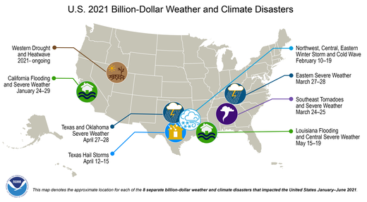
The US experienced 8 billion-dollar weather and climate disasters in the first six months of 2021

From ncei.noaa.gov:


Billion dollar US weather events 2021


  • The eight individual billion-dollar events of 2021 include: two flood events focused in California (January 24-29) and Louisiana (May 14-19); the historic mid-February winter storm and cold wave with impacts focused in Texas; two severe storm events in late-March (24-25 and 27-28) across many southeastern and eastern states, respectively; two severe storm events focused across Texas and Oklahoma in mid-to-late April (12-15 and 27-28); and the expanding Western drought and heatwave that has amplified throughout 2021.
  • In addition to significant economic impacts, the eight events identified during the first half of 2021 resulted in at least 331 fatalities.
  • The most costly U.S. event so far in 2021 was the February 10-19 Winter Storm and Cold Wave with total, direct losses of approximately $20 billion. This is now the most costly U.S. winter storm event on record surpassing (nearly doubling the inflation-adjusted cost of) Superstorm 1993.
  • The January-June 2021 inflation-adjusted costs are at a near-record pace for the first six months, at nearly $30 billion — trailing only 2011.
  • Since these billion-dollar disaster records began in 1980, the U.S. has sustained 298 separate weather and climate disasters where overall damages/costs reached or exceeded $1 billion (based on the CPI adjustment to 2021) per event. The total cost of these 298 events exceeds $1.975 trillion.
See full report here.

Last year the world was hammered by record 50 billion-dollar weather disasters.
 
Weather: how to explain the bad weather that has not left us for weeks?
By Alexandra Tauziac - a.tauziac@sudouest.fr Posted on 07/12/2021 at 5:10 p.m.
The North Atlantic is divided between two semi-permanent atmospheric systems which oppose each other as much as they complement each other. They are the ones who make it rain and shine

Since the beginning of the summer weather, the 1 st of June, the convective rainfall disturbances are occurring at a rapid pace in France. After a month of June when the monthly accumulations most often reached one and a half to two and a half times the normal, especially in New Aquitaine, the beginning of July does not look much better.

Showers, thunderstorms, and even an exceptional storm for the season, Zyprian , during which gusts of winds reaching unprecedented levels for the month of July were recorded: for the moment summer is desired here. How to explain this almost permanent bad weather?

1 High pressure vs low pressure

Generally speaking, the atmospheric pressure at sea level averages around 1013 hectopascals. But in reality, the North Atlantic is divided between two semi-permanent atmospheric systems which oppose each other as much as they complement each other.

In the North: a system of depressions (low pressures) located in the region of Iceland and synonymous with bad weather. A depression tends to suck in the ambient air masses, "like a balloon where one would have created a vacuum," explains Météo-France . The air rushes in and escapes upwards, cooling down as it rises. The water vapor it contains eventually condenses and forms clouds.

In contrast, to the south, is the Azores high pressure (Portugal), synonymous with hot and dry air and high pressures. It functions “like a full balloon that is deflated: air escapes from the sides. It is replaced by air coming from the upper layers of the atmosphere ”, which, as it descends, heats up and dries up, develops Météo-France.

2 Systems that move

But these two systems do not stay in the same place all year round. In this case, the Azores high pressure moves according to the seasons between Bermuda, across the Atlantic, and the Azores therefore, on our side of the ocean. In general, in summer, it is even supposed to get closer to the Bay of Biscay and protect us from bad weather.

However, for several weeks, it has been too far from us, too low and withdrawn in the Atlantic, leaving France under "the influence of very active hollow depressions bringing oceanic air". Clearly, bad weather and cool temperatures, while the Maghreb and Spain suffocated all weekend under its hot air, blocked in place.

3 Not unpublished

Why ? Hard to say. The atmospheric system remains relatively capricious and misunderstood. But a context like this is not new. “It's not our rotten first summer,” realistically sums up François Gourand, forecasting engineer at Météo-France.

However, this “rotten summer” should soon give way to summer itself, since the Azores High will finally approach us. On Wednesday July 14, the bad weather should decrease in intensity before a rise in temperatures and wider clearings on Thursday. And on Friday, summer should finally set in .

Tremendous #tormenta and hailstorm the one that hit last Friday (July 9) the city of #Jinan#Shandong#China They report that the day suddenly darkened with strong lightning, strong wind and #granizo. Via
@dajiyuan


Television - "terrestrial" and unruly lightning
Line-2
This is the result of a lightning strike in a house in the village #Rogoźno ,#Wielkopolska . Author: Fb- OSP Rogoźno

 
Why ? Hard to say. The atmospheric system remains relatively capricious and misunderstood. But a context like this is not new. “It's not our rotten first summer,” realistically sums up François Gourand, forecasting engineer at Météo-France.

However, this “rotten summer” should soon give way to summer itself, since the Azores High will finally approach us. On Wednesday July 14, the bad weather should decrease in intensity before a rise in temperatures and wider clearings on Thursday. And on Friday, summer should finally set in .
It's not his "rotten first summer," perhaps, but it is the first summer like this we have experienced in the two decades some of us have been here. Yesterday and today the daytime high in our corner of southwestern France was 17C, with periodic downpours! It's mid-July!!!
 
It's not his "rotten first summer," perhaps, but it is the first summer like this we have experienced in the two decades some of us have been here. Yesterday and today the daytime high in our corner of southwestern France was 17C, with periodic downpours! It's mid-July!!!

Very warm up here...

And that is probably the reason why in Scandinavia - we have this really warm, long lasting summer this far - with temperatures often close to 30°C and along the southern coasts with tropical nights (minimum not below 20°C) I have been wearing short sleeve shirt at the subway at night for so many weeks (1.5 months now), not even once I have worn a jacket - and we are only half way into summer.

The constant inflow of cool air together with cyclones moving into France and stalling there - creating bad weather (low clouds, rains, chilly) also injecting Thunderstorms to erupt eastwards over Central Europe (where cold and warm air clash) - while up here in the North we've got humid, warm air is flowing in - sometimes from the east - which is partially supported by a high pressure area over Russia. It's been like this for many weeks.

Without the blockage of high pressure over Scandinavia/West Russia - the whole weather pattern over Europe would be quite different (more traditional / typical, I mean)


_-2021-07-13-at-20.14.46.jpg


Hail Events - Northern Italy, etc.
13 July 2021


By the way - the "Milano Hail Event" from 8 July I wrote about, kind of repeated today over Northern Italy and Switzerland and Austria in a similar fashion - even the satellite shows similar characteristics. My husbands best friend, her daughter, send a picture from their home in Turin, Northern Italy a couple hours ago - showing plenty of hail in the street.

I suspect that there must have been plenty of other hail events; like over Switzerland, and near Bologna and Venice (Italy), because the large thunderstorm clusters there, really looked ominous at times. Also over Germany (Thuringa) mega thunderstorms exploded early afternoon.

Actually the T-storm clusters over the wider Turin area seem to got "stuck" (or revived) for many hours (and are still going on), which I believe has something to do with the circulation of the depression over France closing in. The Western Alps being something of a barrier, creating a surge; an increased southerly inflow of humid air from the Gulf of Genoa - maintaining fuel to the region of Turin. Once again, plenty of dynamics getting together there (including Switzerland).


IMAGE 2021-07-13 17:28:51.jpg
Central city of Turin, Northern Italy - 13 July 2021
 
TOLEDO, Ohio (WTVG) - A mural honoring George Floyd erected at Summit and Lagrange in Toledo has collapsed. According to Toledo Police, witnesses say it was destroyed by a lightning strike. 13abc’s Doppler Radar did show a lightning strike in that block at about 4:30 p.m. on Tuesday.

Toledo Police were seen outside the building, which used to house the Mugshots Bar, setting up tape around the pile of bricks that once formed the artwork.

The mural was painted nearly one year to the date of its collapse, in July 2020. Groups have held memorial services for Floyd in front of the mural, including on the one-year anniversary of his death at the hands of Minneapolis Police Officer Derek Chauvin. Chauvin was later convicted of murder and sentenced to 22.5 years in prison.

The building itself is structurally sound, according to a City of Toledo building inspector. The building’s owner is working to clean up the bricks and tear down the rest of the mural wall.

The City of Toledo has already released a statement on the mural, saying they will work with the arts commission on planning for a new mural, or help the commission and the artist find a new location, adding that they were heartbroken to see artist David Ross’s work collapse.Copyright 2021 WTVG. All rights reserved.

 
Back
Top Bottom