Thank you very much NiennaQuite a while ago, a man named Gordon Michael Scallion, said that he foresaw how the world would look like in the future. I can't remember all that he prophesied (it was that long ago). And the map you posted, jess, looks a lot like what I remember. So I looked on the internet under maps of usa in the future and hit upon this article:

Debunked: Leaked US Navy Map, New Madrid, Submerged US
This image purports to be a "Leaked US Navy Map" showing a plan to divide America up with an artificial quake at the New Madrid Fault line: The map has been passed around Facebook with the following description: https://www.facebook.com/roya.ericksonjr/posts/672225519471039 (Leaked US Navy...www.metabunk.org
fwiw
You are using an out of date browser. It may not display this or other websites correctly.
You should upgrade or use an alternative browser.
You should upgrade or use an alternative browser.
CONSPIRACY THEORY AS NAIVE DECONSTRUCTIVE HISTORY
- Thread starter Laura
- Start date
1peacelover
Jedi Master
In the David Chappelle's last SNL he said, "Trump is the best, he's an honest liar.
skymargo
Jedi
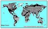
There’s another rather interesting map of the Earth of the Future made relying on Edgar Cayce’s prophesies.Quite a while ago, a man named Gordon Michael Scallion, said that he foresaw how the world would look like in the future. I can't remember all that he prophesied (it was that long ago). And the map you posted, jess, looks a lot like what I remember. So I looked on the internet under maps of usa in the future and hit upon this article:
Debunked: Leaked US Navy Map, New Madrid, Submerged US
This image purports to be a "Leaked US Navy Map" showing a plan to divide America up with an artificial quake at the New Madrid Fault line: The map has been passed around Facebook with the following description: https://www.facebook.com/roya.ericksonjr/posts/672225519471039 (Leaked US Navy...
fwiw
Even during his lifetime, on the basis of his predictions, a map of the post-apocalyptic world was drawn up, where all the safe places on the planet were plotted (flood zones highlighted in black).
He said “Human civilization will almost perish at the beginning of the 21st century. The planet will be shaken by a series of monstrous natural disasters: earthquakes, floods, volcanic eruptions, tsunamis, rises and falls of land that will change the face of the Earth”.
Attachments
Herbal witch
Jedi Master
No one can know for sure if either of those maps are accurate. We'll have to wait and see.There’s another rather interesting map of the Earth of the Future made relying on Edgar Cayce’s prophesies.
Even during his lifetime, on the basis of his predictions, a map of the post-apocalyptic world was drawn up, where all the safe places on the planet were plotted (flood zones highlighted in black).
He said “Human civilization will almost perish at the beginning of the 21st century. The planet will be shaken by a series of monstrous natural disasters: earthquakes, floods, volcanic eruptions, tsunamis, rises and falls of land that will change the face of the Earth”.
However, looking at both maps independently, I can attest that the Scallion map makes more sense in some areas than Cayce's. Why?
In my region, we live in a flood plain. We've had many instances of flooding through the years and it is getting worse by the year as the climate is changing with the sun's labors on our planet.
Scallion shows our area to be completely flooded out. Makes sense to me. I'm no geologist but if the axis of our planet changes, it goes without saying that the water in the Hudson Bay's water will need to go somewhere!
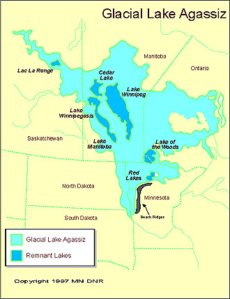
The Northern region was once a huge lake called Lake Agassiz. (please see below)
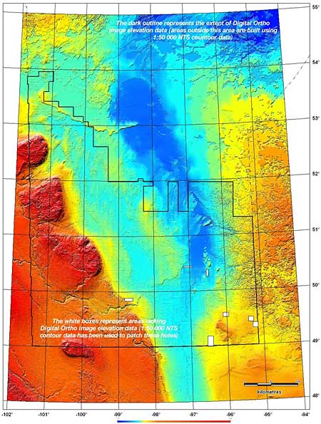
Red River Valley
Introduction:A three-dimensional perspective of the Red River valley in southern Manitoba derived from the MGS Digital Elevational Model. The provincial capital, Winnipeg, appears as the gray region directly south of Lake Winnipeg. The dramatic rise in elevation to the west reflects the beginning of the Manitoba escarpment, where Cretaceous shales mark the division between the first and second levels in the Canadian prairies. The rugged Canadian Shield occupies the northeastern portion of the image.
The wide valley flanking the Red River was formed as a major depositional basin of glacial Lake Agassiz, and, as a result, is covered by tens of meter's of clay. The Pembina and Assiniboine channels are deeply incised into the Cretaceous shale above the escarpment and have deposited large sand and gravel fans at the base of the escarpment where they entered Lake Agassiz. Because these proglacial channels (called ‘spillways’) have eroded into shale, they are the primary source of the clay deposited in the Winnipeg area.
The modern Red River flows northward across this extraordinarily flat relict lake bottom and, as a consequence, southern Manitoba has often been affected by extreme spring floods spilling across the entire valley. The second image shows the extent of the 1997 flood within the Canadian portion of the Red River valley. The 1997 flood is the second largest flood in the Winnipeg-region in at least 350 years, exceeded only by the record Red River flood of 1826.
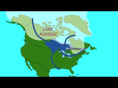
Ancient Global Warming Caused Flood Which Caused Ancient Global Cooling
As the giant North American ice sheets melted an enormous pool of freshwater, many times larger than all of the Great Lakes, formed behind them. About 8400 years ago this pool of freshwater burst free and flooded the North Atlantic. About the same time, a sharp century long cold spell is...
"Ancient Global Warming Caused Flood Which Caused Ancient Global Cooling
As the giant North American ice sheets melted an enormous pool of freshwater, many times larger than all of the Great Lakes, formed behind them. About 8400 years ago this pool of freshwater burst free and flooded the North Atlantic.
About the same time, a sharp century long cold spell is observed around the North Atlantic and other areas. Researchers have often speculated that the cooling was the result of changes in ocean circulation triggered by this freshwater flood. The sudden addition of so much freshwater would have curtailed (suppressed) the sinking of deep water in the North Atlantic and as a consequence less warm water would be pulled north in the Gulf stream." (from the website above)
Now is this accurate or not? We all know that we are not fed the right info no matter what. The elevation of the land is a better indication of where the water will go if the axis of our planet changes. That is, in my view (just common sense, not a geologist after all) what is more likely to happen.
Also, no mention of other lands that may uprise while the flooding occurs. (Atlantis, ancient Lemuria, others???)Combined with the fires and earthquakes and of course, volcanoes erupting, no one can really predict what will happen with accuracy.
I hope this does not scare the people in this forum living in the prairies. Remember that this won't happen overnight. It will go by stages, judging from what the C's have confirmed.
Anyone else who have more info, please join in. I really want to learn from your experience/knowledge in this matter.
Last edited by a moderator:
Herbal witch
Jedi Master
I simply wanted to add that this may also be an alternative universe. Cayce did his predictions on what could have happened at that particular time he lived in. The same with Scallion. Their maps may be accurate, and then again could be something we do not even anticipate. Our earth is really dynamic and ever changing with the seasons and the times. No one can predict exactly how this will affecting every regions and living in fear of where we are is not really productive either. This is only an observation on my part, not an actual fact! Living in 3rd density is so restrictive, isn't it?I hope this does not scare the people in this forum living in the prairies. Remember that this won't happen overnight. It will go by stages, judging from what the C's have confirmed.
Anyone else who have more info, please join in. I really want to learn from your experience/knowledge in this matter.
And as this thread was about debunking a US Navy map based on Scallion, their limited shortsightedness is evident in everything they do. HAARP and other factors in our environment will ensure that whatever disinformation they publish will only increase the division on people and the information highway. I look forward to see information in the future where everything is true and not constructed!
This reminds me of the questions to the Cs re the axis of our earth currently sits at 23.5 deg. (session of January 14th, 2023)The C's have indicated that it will get back to 0 deg eventually, but no way of knowing when. We will all be affected, no matter where we are currently or located in the future. I hope my explanation is better understood. Don't want to alarm anyone. Future is so unknown!
If what I've written should be going somewhere else in the blog/forum, please change away!
Thanks community. Comments are greatly appreciated.
BHelmet
The Living Force
I remember he was an Art Bell regular. Not sure if that means anything.Quite a while ago, a man named Gordon Michael Scallion, said that he foresaw how the world would look like in the future. I can't remember all that he prophesied (it was that long ago). And the map you posted, jess, looks a lot like what I remember. So I looked on the internet under maps of usa in the future and hit upon this article:
fwiw
unkl brws
Dagobah Resident
The Psychology of Conspiracy Theorists: More Than Just Paranoia

The Psychology of Conspiracy Theorists: More Than Just Paranoia - Neuroscience News
A new study delves into the intricate psyche of conspiracy theorists, attributing their beliefs to a mixture of personality traits and motivations.
Summary: A new study delves into the intricate psyche of conspiracy theorists, attributing their beliefs to a mixture of personality traits and motivations.
The study suggests conspiracy theorists are not necessarily ‘mentally unwell’, but often resort to conspiracy theories to fulfill unmet needs and rationalize distress. Analyzing data from 170 studies with over 158,000 participants, it identifies a need to understand and feel secure in their environment, and a sense of superiority over others as key drivers.
In addition, personality traits such as paranoia, insecurity, impulsivity, and egocentrism were found to be common among conspiracy theorists.
BHelmet
The Living Force
So, by correlating conspiracy theorists to personality traits (with loaded connotations) with an accompanying thick layer of graduate thesis jargon, the authors sidestep the simple act of noticing objective reality that doesn’t make sense and looking for the reasons why.The Psychology of Conspiracy Theorists: More Than Just Paranoia
The Psychology of Conspiracy Theorists: More Than Just Paranoia - Neuroscience News
A new study delves into the intricate psyche of conspiracy theorists, attributing their beliefs to a mixture of personality traits and motivations.neurosciencenews.com
I think it’s called obfuscation.
Goemon_
The Living Force
My basic thinking. There is a new study about the psychology of conspiracy theorists. What is their definition of conspiracy theorists ? > ctrl + F conspiracy t > no definition found. Conclusion: nothing to see here.So, by correlating conspiracy theorists to personality traits (with loaded connotations) with an accompanying thick layer of graduate thesis jargon, the authors sidestep the simple act of noticing objective reality that doesn’t make sense and looking for the reasons why.
I think it’s called obfuscation.
Interestingly this little search lead me to the last occurrence of the term on the webpage which is the only comment left below the study:
Not bad.And what if the conspiracy theories are actually true? What if the propaganda machines operated by governments the world over figured on naming all opposing beliefs that don’t fall into line “conspiracy theories”? Or is that just another conspiracy theory? Oswald was the lone gunman- Riiight…
Trending content
-

-
Thread 'Coronavirus Pandemic: Apocalypse Now! Or exaggerated scare story?'
- wanderingthomas
Replies: 30K -
 Thread 'Mass Shooting at Bondi Beach, Sydney, targets Jews celebrating Hanukkah'
- Rhythmik
Replies: 133