Crazy Storm Weather and Lightning - Global


Most intense storm on the planet pounding Newfoundland and Labrador, say officials | CBC News
12,000 customers without power, according to Newfoundland Power
CBC News · Posted: Nov 15, 2018 6:54 AM NT | Last Updated: an hour ago
Newfoundland and Labrador is in the throes of the "most intense storm" on the planet, according to a meteorologist in Gander.

Wild, whipping winds gusting upwards of 130 km/h are causing huge waves, delays, cancellations and closures across the province.

"[It's] not fun to be out in, or drive anywhere in," said Tabea Fiechter, a meteorologist with the weather office in Gander.
According to Newfoundland Power, there are 12,000 customers in the province without power because of severe weather and winds.

nf-power-outages.png

Red symbols indicate outages affecting 1,000 or more customers. Orange indicates 200-1,000 customers affected. (Newfoundland Power)

Trees have blown over into power lines and whiteout conditions are making repairs difficult, said Michele Coughlan, a Newfoundland Power representative.

"It's not just one or two trees, it's seven trees, five trees. And as you get one tree removed the crews are finding that there are other trees that have come into line."

In St. John's, flying debris has shut down Prince Philip Drive from Westerland Road to Morrissey Road.


Environment Canada has issued wind warnings for most of the Avalon, with storm surge warnings affecting the northeast and east coasts of the peninsula.

More exposed areas of the northeast Avalon coast like Bonavista and Twillingate are ducking under sustained winds of 100 km/h and gusts of 140 km/h, Fiechter said.

With that wind, nine-metre-high waves are pounding that coastline, she said.
"[There is] definitely potential for damage in those areas."

The Northern Peninsula and west coast of the island are under winter storm warnings.
Wind warnings have been issued for Makkovik and Rigolet, while the rest of the Labrador coast braces under winter storm warnings.

Many flights at the St. John's International Airport, the Gander Airport and the Deer Lake airport are cancelled or delayed.
Marine Atlantic has cancelled its crossings for the day, and Labrador Marine says the Apollo ferry will likely stay tied up today as well.

All schools in Gander and Corner Brook have also been closed for the morning, and many schools in Labrador, central Newfoundland and the Avalon region have been delayed for the morning.

For the latest updates on closures, delays and cancellations, check out our Newfoundland Storm Centre and our Labrador Storm Centre.

Blowing snow

The west coast has seen a bit of snow, most notably in areas in higher elevations around Marble Mountain and Deer Lake, she said.
The concern is not the accumulation, which she said will be minimal, but the effects of the wind on that snow.

"It doesn't take a lot of snow with this kind of wind to really reduce visibility," she said.

There is a blowing snow advisory for Gander, and drivers in Twillingate and Bonavista will also have a tough time seeing the road ahead, she said.

Winds to subside Thursday night

Winds will start to die down Thursday afternoon in most areas, Fietcher said, but only slightly — those exposed areas along the northeast Avalon coast will still have gusts up to 110 km/h throughout the afternoon.

Throughout the night, she said, winds will stay gusting between 50 km/h and 80 km/h, and will then start slowing down.
Read more articles from CBC Newfoundland and Labrador
 
November 16, 2018 - Cyclone 'Gaja' makes landfall in South India, kills 11 people
Cyclone 'Gaja' makes landfall in south India, kills 11 people | Reuters


A fallen pole and a damaged motorbike are seen in a road after cyclone Gaja hit Velankanni, in Nagapattinam district in the southern state of Tamil Nadu, India, November 16, 2018. REUTERS/Stringer

A cyclone made landfall in the southern Indian state of Tamil Nadu on Friday, killing at least 11 people, uprooting trees and knocking down electricity poles after more than 80,000 people were moved out of its path to safety, officials said.

Cyclone “Gaja” made landfall in the early hours of Friday but then weakened as it moved inland, K. J. Ramesh, director general of the state-run India Meteorological Department, told Reuters.

Eleven people were known to have been killed said an official from the Tamil Nadu State Disaster Management Authority.

The state government has set up more than 470 relief camps and had evacuated more than 80,000 people from their homes in vulnerable areas, said the official who declined to be identified as he is not authorized to speak to media.

Tamil Nadu Chief Minister Edappadi K Palaniswami announced compensation of 1 million rupees ($14,000) for the families of those killed.
 
19.11.2018 - Watch Gigantic Waves sweep away Balconies in Tenerife
WATCH Gigantic Waves Sweep Away Balconies in Tenerife

Dozens of people have been evacuated from their houses during the storm that erupted on the northern coast of Tenerife, the largest of the Canary Islands.

A video posted on Twitter shows enormous waves striking a Marisol de Mesa house, sweeping away the railings from concrete balconies.

Some six-metre waves have crashed into buildings and restaurants, causing considerable damage, according to witnesses.

The Spanish meteorological agency earlier issued an orange-level alert for the storm in the Canary islands, which lasted two days.

⚠️IMPRESIONANTE | Capturan el momento justo cuando el Fuerte Oleaje Arranca las Barandas de los balcones del Marisol de Mesa del mar, Tenerife — España. 18/11/2018.

The city of Tenerife, Tacoronte Mayor, Alvaro Davila has stated that no one has been injured and the necessary arrangments for those affected by the storm have been taken.


After eight (!) Years of thunderstorm hunting, we wanted to make something special for you. We are pleased to present you the Best of Thunder-storm, with many of the highlights from the last years!

What you see here is the result of more than 150,000 kilometers across Central Europe, offering everything from unbelievable light, to dangerous, dangerous and quite scarce situations, to the epic show of the heavens.

All of us verb
 
11.25.2018 - Hundreds of flights canceled as Midwest braces for Snowstorm
Hundreds of flights canceled as Midwest braces for snowstorm

CHICAGO (AP) — A winter storm blanketed much of the central Midwest with snow on Sunday at the end of the Thanksgiving weekend, bringing blizzard-like conditions that grounded hundreds of flights and forced the closure of major highways on one of the busiest travel days of the year.

"It's going to be messy," said Todd Kluber, a meteorologist for the National Weather Service who is based in suburban Chicago.

With much of the central plains and Great Lakes region under blizzard or winter storms warnings, roughly 600 flights headed to or from the U.S. had been canceled as of 2 p.m. Sunday, according to the flight-tracking website FlightAware.

Most were supposed to be routed through Chicago or Kansas City — areas forecast to be hit hard by the storm.

Strong winds and snow created blizzard conditions across much of Nebraska and parts of Kansas, Iowa and Missouri. The National Weather Service was warning those conditions would make travel difficult in places.

By mid-day, the blizzard warning was extended to parts of the eastern Illinois near Chicago, where snow is forecast to fall at a rate of about 2 inches per hour.

Other parts of central plains and Great Lakes region were under a winter storm warning, that could see a foot or more of snow dumped in some places by the end of the day.

In eastern Nebraska, part of Interstate 80 between Lincoln and Omaha was closed Sunday morning because of multiple accidents after snow blanketed that area. That included semitrailer trucks jackknifed across the highway. It was re-opened by Sunday afternoon.

In Kansas, Gov. Jeff Colyer issued a state of emergency declaration. The action came as a large stretch of Interstate 70, spanning much of the state, was closed between Junction City and WaKeeney.

Separately, a portion of Interstate 29 was shut down in Missouri, near the Iowa border.

As much as a foot was expected in Chicago. Between 4 to 6 inches of snow was expected in the Kansas City area. Forecasters predict more than a foot of snow is likely in southeast Nebraska, northeast Kansas, northwest Missouri and southwest Iowa.

By Monday morning, the storm was expected to hit parts of northern Indiana and southern Michigan.

Kluber said the storm was expected to hit the Chicago region sometime Sunday evening. He said rain will give way to heavy snowfall and "near whiteout conditions" that will make for dangerous travel.
 
Parts of Vancouver still under water as king tides continue
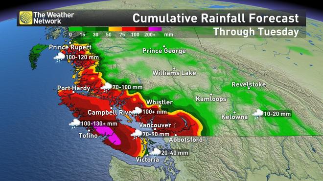
Monday, November 26, 2018, 8:01 PM - Weather warnings remain in effect for much of the south coast of British Columbia and Vancouver Island as an intense and damaging storm blasts the coast in what may be the strongest of the fall season to date. Strong, potentially damaging winds and heavy rain will persist through Tuesday, bringing upwards of 100 mm to some communities, heightening the threat for floods, landslides and power outages. More on the timing and greatest impacts, below

1085


12.08.2018 - Risk of iced roads grows as snowstorm closes in on North Carolina (Video)
Risk of iced roads grows as snowstorm closes in on North Carolina

Drivers in North Carolina faced a growing risk on Saturday of roads glazed with ice as a major winter storm drew near, with the National Weather Service warning of more than a foot of snow in the state's mountainous west before the weekend was out.

The snow is due to arrive after dark, with the heaviest falls expected in the early hours of Sunday morning.

North Carolina Governor Roy Cooper, who declared a state of emergency on Friday, told residents to finish their food stockpiling and other storm preparations and to avoid unnecessary travel.

"Prepare for DAYS of impact not hours," North Carolina Emergency Management warned residents in a statement. Tens of thousands of homes could lose power, the agency said.

The storm may affect airports including Asheville and Raleigh-Durham International in North Carolina, Lynchburg and Roanoke in Virginia and Greenville-Spartanburg International, South Carolina. Americans Airlines said it would waive change fees for people booked through Charlotte Douglas International, a major regional hub in North Carolina.

Some of North Carolina's roads may disappear under ice up to a quarter of an inch (half a centimeter) thick, the National Weather Service said.

The heaviest snowfall, perhaps knee-height or more, was forecast for the cities of Winston-Salem, Greensboro and Lexington. Raleigh, the state capital, faced an uncertain mix of sleet and freezing rain, the National Weather Service said.
 
Cars Stuck in Heavy Snow Across North Carolina - Aerial View
Published on Dec 10, 2018
Heavy, wet snow left cars stuck in North Carolina.
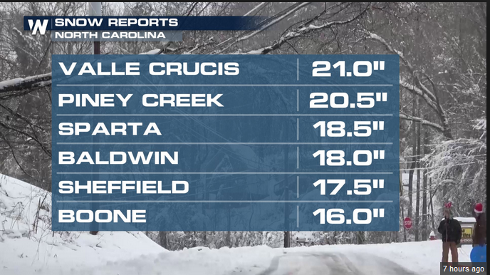
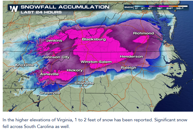
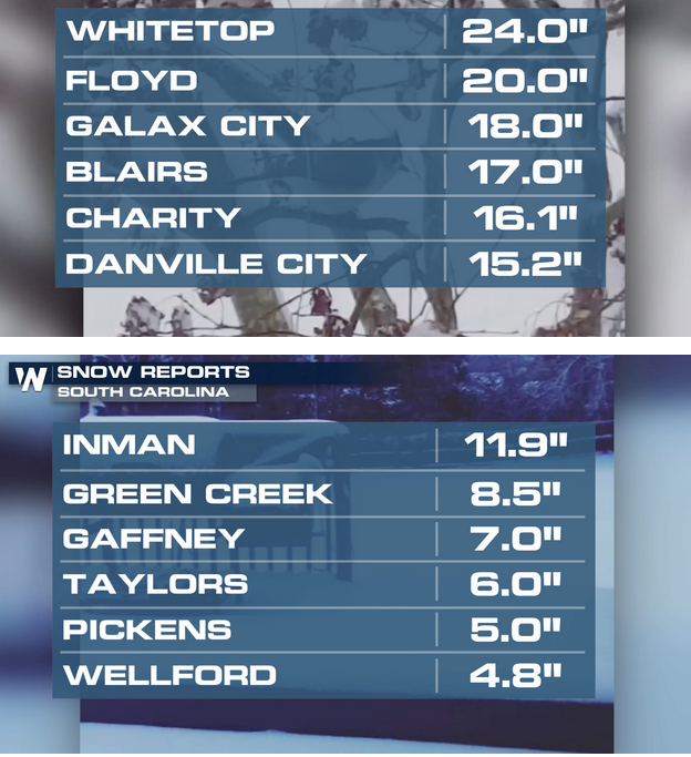
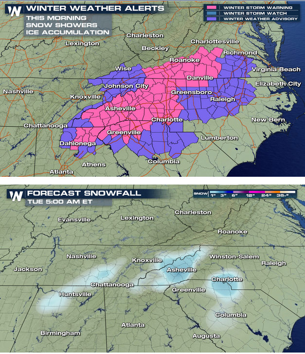
A major storm dumped snow and ice across portions of the Southeast over the weekend. North Carolina saw some of the biggest winter weather impacts. Snow amounts have totaled close to 21 inches for the higher elevations of North Carolina. The Raleigh-Durham area totaling close to 9 inches in many spots as well.
601de71adb141cfad27757d14496430b.png


10f94e55db4a426b297c80a96313e91b.png

e490b675337ae63468a21f856b307915.png

The snow has been heavy, but the changeover to freezing rain as well as a sleet/snow mix produced ice accumulations. This has made for treacherous roads over the region.
ezgif.com-video-to-gif-6.gif

Winter weather alerts remain in effect as lingering snow showers continue. Some light freezing drizzle is also possible.
3011130dc665fe971b696658e42fe2f3.png

Snow tapers off this morning; however, more moisture will move through parts of western North Carolina, South Carolina and far northeast Georgia. This means another round of light snowfall. The storm will finally clearing out later today (Monday). Many schools in North Carolina and Virginia have been cancelled due to the difficult travel.
Keep checking with WeatherNation for more updates.


The snow has been heavy, but the changeover to freezing rain as well as a sleet/snow mix produced ice accumulations. This has made for treacherous roads over the region.

The guy in the truck in Chimney Rock, N.C. wouldn't be burning all that rubber - had he been smart enough to carry a 5-10 lb. bag of sand with him for emergency icy conditions. Cheaper - then getting a set of new tires.

December 10, 2018 - 500-Plus Monday Flights Canceled, 200,000 Customers in the Dark After Brutal Southeast Storm
500-Plus Monday Flights Canceled, 200,000 Customers in the Dark After Brutal Southeast Storm

The brunt of the storm may have passed, but North Carolina residents still face perilous conditions after record-setting snow walloped the state.

“With a mix of snow, ice and rain still coming down in some areas, conditions remain treacherous in many parts of our state,” Gov. Roy Cooper said Monday.

The storm, which pummeled the Southeast over the weekend, killed at least one person in North Carolina and grounded thousands of flights in the region, including more than 500 flights on Monday.

About 144,000 North Carolina households are still without power Monday morning, the governor said.

In South Carolina, emergency officials said more than 56,000 power customers are without electricity Monday.

With frigid conditions and widespread power outages, Cooper asked residents to check on vulnerable loved ones and the elderly, if possible. He said 15 emergency shelters have opened across North Carolina.

Thousands of airline passengers are stuck
About 3,000 flights were canceled over the weekend due to the storm, but more travel misery is expected, CNN meteorologist Chad Myers said.

Many of the flights were canceled at North Carolina’s Charlotte Douglas International Airport and Raleigh-Durham International Airport, as well as Richmond International Airport in Virginia.

“If you are flying today, even if you’re flying out of Tampa, your plane may be stuck in Raleigh, so this is going to be a dreadful day to fly,” Myers said Monday.

Record-breaking snow pounds the Southeast
Up to 24 inches of snow covered parts of the Appalachian Mountains region over the weekend, CNN meteorologist Pedram Javaheri said.

Cooper said while the worst of the storm has passed North Carolina, “we need to stay vigilant. We’re not out of the woods yet.”

“This storm dropped staggering amounts of snow, ice and rain across our state,” the governor said. “A year’s worth of snowfall or more fell on some places in a little more than a day.”

Javaheri said snow showers could remain until mid-afternoon Monday.

And with temperatures dropping below freezing overnight into Tuesday, the threat of icy roads will linger. North Carolina State Highway Patrol warned that even after streets are treated, they can freeze over again.

“Watch out for deadly black ice, especially tonight and tomorrow morning,” Cooper said.

Fallen tree leads to driver’s death in North Carolina
In the Charlotte suburb of Matthews, a tree fell on a vehicle, causing the car to careen and crash into a church, police said. The driver died, and the passenger was taken to a hospital with minor injuries.

In total, 672 crashes were reported during the storm, North Carolina State Highway Patrol said.

The Durham County Sheriff’s Office tweeted a photo of a damaged patrol car, warning drivers should be prepared for hidden dangers.

“Another example of the unpredictable happening while driving in #winterweather,” the department tweeted. “A chunk of ice fell from an overpass and cracked a deputy’s windshield. Thankfully he was ok. If you can’t stay home, stay alert. #ncwx #DurhamWeather,” the tweet read.

State highway patrol said anyone who must drive should leave twice as much following space as normal behind the next car, in case that vehicle loses control.

Virginia extends winter storm warning
Virginia was also bombarded with snow, and a winter storm warning remains in effect for most of the state until to 2 p.m. ET Monday, CNN meteorologist Gene Norman said.

Over the weekend, the Richmond area got about 9 inches of snow, said the National Weather Service in Wakefield, Virginia. Areas south of Richmond got 6 to 8 inches of snow, Norman said.

Like its neighboring states to the south, Virginia also suffered thousands of power outages and dozens of vehicle crashes.

As of Monday morning, at least 33,000 customers had no electricity, Dominion Energy Virginia said.

And just like in North Carolina, roads are still dangerous in Virginia.

Virginia State Police reported 1,177 crashes since Sunday morning and asked residents to stay off the roads Monday.

State police said it’s important to keep streets clear so Department of Transportation workers can access roads.


December 10, 2018 - Frigid nights, black ice to follow southern US snowstorm through midweek
Frigid nights, black ice to follow southern US snowstorm through midweek

Following the storm that dropped up to 2 feet of snow and cut power to hundreds of thousands into Monday, frigid nights will set the stage for difficulties for those without a means for heat and motorists venturing on icy roads.

Areas from North Georgia and northernmost South Carolina to eastern Tennessee, eastern Kentucky, central and western North Carolina, southern West Virginia, central Virginia and southern Maryland were hit with heavy snow and/or ice from the most recent storm.

Cold times ahead for those without power

While crews have already begun the restoration process, tens of thousands may remain without power into the middle of the week.

As of 9:00 a.m. EST Monday, there were nearly 280,000 people without power in the wake of the storm. This includes outages in the states of North Carolina, Virginia, South Carolina and Tennessee.

Even after the storm departs, wintry trouble will remain.

"A clear sky, light winds and an extensive deep snow cover will allow temperatures to plummet at night," according to AccuWeather Meteorologist Courtney Travis.
Temperatures are forecast to dip into the teens and 20s F Monday night and Tuesday night and into the 20s to lower 30s Wednesday night.

Download the free AccuWeather app to see how cold the weather will be for your area.

Record lows this time of the year are generally in the single digits to middle teens. However, under perfect conditions, a few spots may have temperatures dip to record-challenging levels.

Overall, temperatures will average as much as 10 degrees below normal through Wednesday.
 
The guy in the truck in Chimney Rock, N.C. wouldn't be burning all that rubber - had he been smart enough to carry a 5-10 lb. bag of sand with him for emergency icy conditions. Cheaper - then getting a set of new tires.
December 10, 2018 - 500-Plus Monday Flights Canceled, 200,000 Customers in the Dark After Brutal Southeast Storm
500-Plus Monday Flights Canceled, 200,000 Customers in the Dark After Brutal Southeast Storm


Add:

Published on Dec 10, 2018
Winter Storm Diego dumps a years worth of snowfall in a single day in the South East USA, hundreds of thousands without power, while in Europe blizzards rage as an extra tropical low collides with a cold air front dumping three feet plus of snow across France, Italy, Austria, and Russia with its own blizzard burying herds of animals. Interestingly the global main stream media does not want to talk about low solar activity as a possible cause for the extreme weather as predicted by solar forecasters to start now. 2+2 =3.33 in the world of mind control
 
Back
Top Bottom