Crazy Storm Weather and Lightning - Global

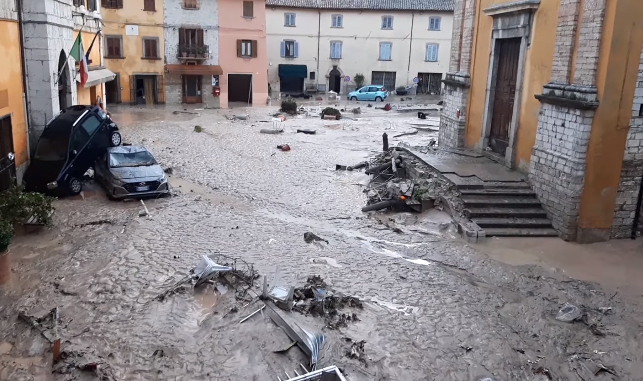
Several people are missing and dozens of vehicles have been swept away as catastrophic floods hit Italy's Marche region following SIXTEEN inches of rain in just seven hours​


▪︎The huge amount of rain was recorded in Cantiano, 16 inches in seven hours
▪︎Clips show people wading through muddy floodwater and submerged cars
▪︎Flooding is part of a wave of storms currently hitting regions across Italy
▪︎Farmers association Coldiretti says it is the 1,642th extreme weather event of summer

Footage also shows a huge mud river in Sassoferrato and a flooded Sentino river as dirty water last night swept through the streets.

The huge deluge of water appears to be carrying debris and hits a building as people watch on and emergency vehicles are seen in the background.

Another video shows more fast-flowing downpours overtaking the streets of Senigallia as emergency services arrive on scene.

The flooding hitting the Marche region, is, according to Ansa, part of a wave of storms hitting the country.

Other regions experiencing storms are Tuscany, Umbria, Abruzzo, Fruili Venezia Guilia, Lombardy, Liguria and Molise.

62466135-11217979-image-m-13_1663289577692.jpg


News Bilder des Tages Town of Cazma in Croatia hit by a heavy storm. Strong wind overturnes three trucks i​


News Bilder des Tages Town of Cazma in Croatia hit by a heavy storm Strong wind overturnes three trucks in heavy storm that hits Cazma in Bjelovar-Bilogora County in Croatia, on September 15, 2022.

A violent storm with winds of over 100 km/h causes severe damage in Čazma, Croatia.

 
Adriatic Region (N Italy, Slovenia, Croatia), Middle Europe
16 Sep 2022

With rain up to 420 mm (16.53 inches) within a very short time (a whopping 200 mm in two hours), it was bedded for disaster in the aforementioned region - as it is unfortunately often the case during autumn in places along the Mediterranean sea !

Vulkane.net wrote following today:


307385142_2187451374769884_4043689075607518282_n.jpg
Severe storms hit the province of Marche in Italy. © Cantiano di Daniela Bertinelli

Storms cause catastrophic flash floods in Adriatic region
by Marc Szeglat

Severe storms have hit the Adriatic Sea in the past few days, causing great damage. According to preliminary data, at least 10 people died. Several people are considered missing. Italian, Croatian and Slovenian localities were affected.

The storms began on the Italian side of the Adriatic. The region of Ancona in the eastern Italian province of Marche was hit particularly hard. Within a few hours, up to 420 mm of precipitation fell, which is about a six-month average of rain. Even small streams turned into raging torrents that burst their banks. The water levels rose so quickly that people had to climb onto house roofs and trees to avoid being swept away. Not everyone was able to do this, however, and several people in Marken were swept away by the waters. Among the fatalities are 2 children who were travelling with their mothers. One mother survived the disaster.

The mayor of the small town of Castelleone di Suasa, Carlo Manfredi, said in an interview with the Italian broadcaster RAI 24 News: "We have witnessed apocalyptic scenes. Plants and trees were torn away like twigs. Unfortunately, we are still looking for an eight-year-old boy. Fortunately, last night we found the mother still alive". There were reportedly no warnings about the heavy rain.

The rescue forces were working non-stop. Not only did they have to rescue people, they also had to pump out flooded cellars, clear roads of washed away cars and fallen trees, and regulate traffic as there were power cuts. The rain also caused mudslides.

In Croatia and Slovenia, the storms hit yesterday afternoon. Strong gusts of wind covered roofs and up to 300 mm of rain fell. Flooding also occurred in localities here as streams and rivers burst their banks.

A severe weather warning of the highest level is still in effect for the region. Another 400 mm of precipitation per square metre could fall *** The blame for the explosive weather situation lies with the heated Adriatic Sea, over which warm air masses from the south meet with cold air currents from the north.

Severe storms also in the US state of California

Severe storms with heavy rain also hit the US state of California. San Bernardino County was badly affected. Flooding, landslides and mudslides occurred. The parched soils could not absorb the water masses of the heavy rain and were eroded. In the forest fire areas, particularly pronounced mud floods developed, in which the ash of the burnt vegetation was mixed.


END OF ARTICLE

*** ) i checked with the GFS prognosis, but they do not give support for additionally 400 mm rain in the region during the next 10 days, "only" 75 mm rain at the most.

After the devastating flood that hit the Marche region, causing victims and considerable damage, the ANBI Observatory on Water Resources released some data provided by the Regional Hydropluviometric Weather Network.

• In Cantiano , the most affected municipality, 420 mm of rain fell from 15.00 to 22.30 (of which almost 200mm between 17.00 and 19.00), about half of what it rained in all of 2021 and the temperature it dropped from 26 ° C at 2.00 pm to 17.3° C at 4.00 pm.

• In Barbara , 127mm of rain fell from 15.00 to 22.45 ( 80mm from 17.30 to 19.30). In Scheggia 187.2mm (over 50mm in 30 minutes).
• The Misa river overflowed in Senigallia (where it rained only 5.6mm ): at 10pm it was 21cm high , at 11.45pm it was 5.31 meters high !
• The river Sentino , which in recent days had touched one of the many negative records ( -41cm ), at 19.30 yesterday had risen to 3.67 meters !

Source: meteoweb.eu (careful, they got lots of ads and hijacks on their sites)


This map shows the integrated water transport over the Adriatic region outlined.

alluvione-marche-15-settembre-2022.jpg


24 hour rain accumulations over Europe
18 Sep 2022 06:00 - 19 Sep 2022 06:00 UTC

RR24h_obs_eu-large_day0.jpg
 
Severe weather all over Croatia:

- after a severe storm in the north of Croatia on 15.9., see the post above from Puma, where the wind took off the roofs and turned over the trucks, the weather continues to be a threat.

- floodings in the central Croatia (video here)
1663438192024.png

- In Ogulin (mountain regions Croatia) a record rainfall in the history of measurements, record rainfall across the entire mountain areas.

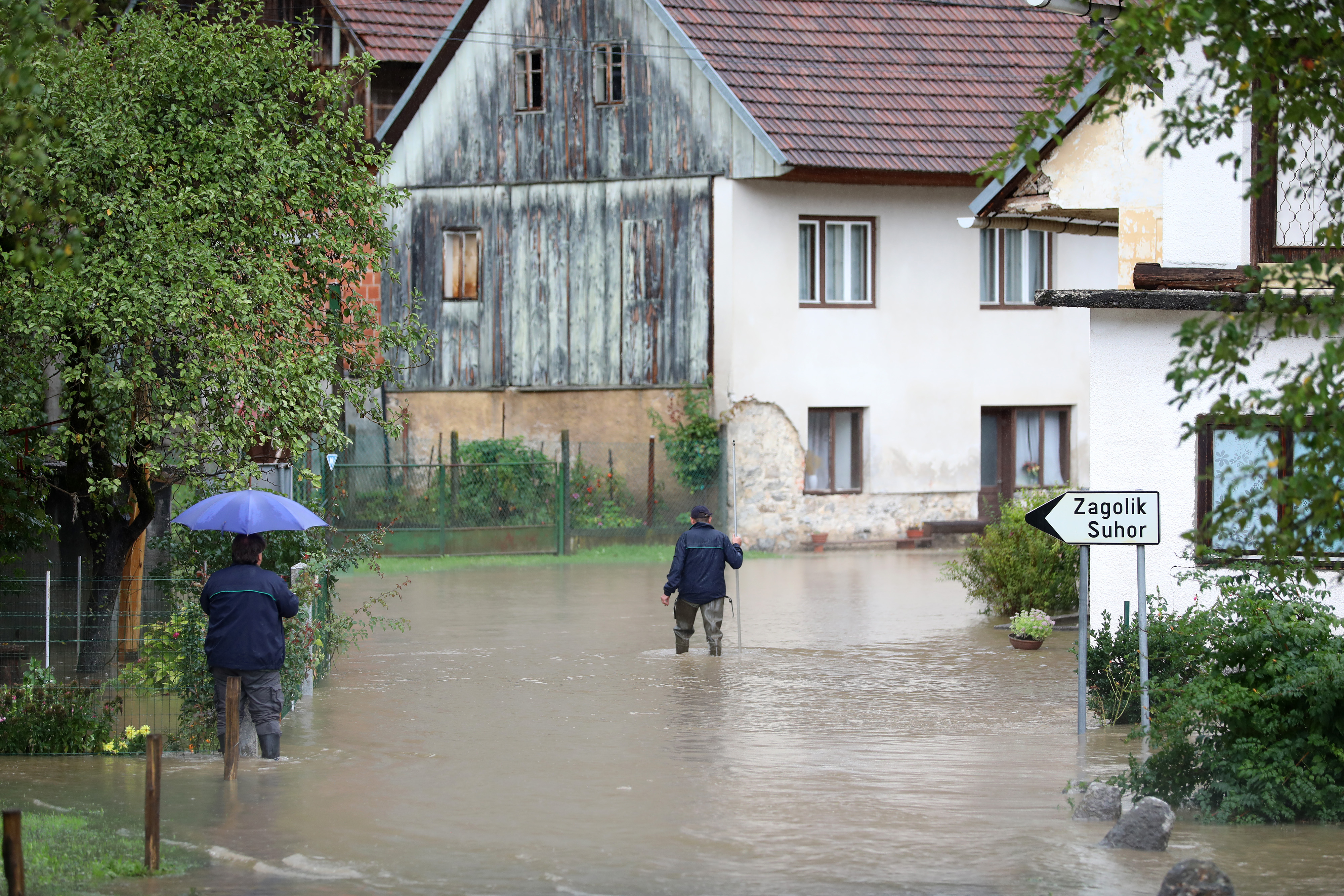
- overflowing of the Kupa River - a state of emergency was declared. In Brod na Kupi - in Gorski kotar - the water level of the river rose by as much as four meters in just a few hours. Some villages were cut off, and roads in that part were closed.

- record rainfall in the entire Gorski Kotar (mountain areas) - Locals don´t remember this much rain in last 30 years.
In Crni lug, a record 192 liters of rain per square meter fell, which is unprecedented in that area.

1663437948881.png

- Hail in Zagorje (north of Croatia)

- Sava river is on the rise in Zagreb (central Croatia), after days of rain now there are floodings in the streets


- Kupa river is on the rise in Karlovac (central Croatia), increased danger of flooding, and preparations are being done. The Kupa water level is at its highest level since 1966.

- The village of Jurovski Brod flooded in Karlovac County

1663438012736.png
1663438254973.png
1663438271734.png

- Kupa river already flooded the town Brod na Kupi (central Croatia)

1663438298392.png

- On the mountain Zavižan is snowing!!!! (moutain regions Croatia)
1663438067648.png

- As well in Slovenia!

1663438084742.png
 
▪︎Spain

Firefighters rescue a person who was trapped in floods in the city of #Mataró, #Barcelona, Spain.

Dramatic rescue of a man in Mataró. As can be seen in the video, a group of people try to pull the person out of a sinking car. The video shows how the vehicle sinks and ends up completely submerged. Up to six people, including firefighters and police officers, are in the water to try to pull out the 63-year-old man.

The events took place this Friday shortly before 20.00 hours, when the city of Maresme fell a major downpour of water.

Sea storm captured in Barcelona, Spain.

▪︎ Mexico

Forecast of accumulated rainfall from Saturday to Monday above 200mm in Guerrero and above 150mm in Veracruz Chiapas, Tabasco, Oaxaca, Michoacan Colima and Jalisco. Possible floods landslides and mudslides with swells.
 

▪︎Puerto Rico​

Hurricane Fiona Knocks Out Power in Puerto Rico, Governor Says​


Hurricane Fiona made landfall in Puerto Rico on Sunday afternoon after knocking out power to all of Puerto Rico, its governor said, as forecasters warned that the storm could bring as much as two feet of rain and cause life-threatening floods and landslides.

Nearly 1.5 million customers were without electricity on Sunday afternoon, according to poweroutage.us, which tracks power interruptions.

Because of the hurricane, the power grid was out of service, the governor, Pedro Pierluisi, said on Twitter. “Protocols have been activated based on established plans to address this situation,” he said.

The collapse of the electrical grid came five years after Hurricane Maria battered Puerto Rico and knocked out the island’s power. Since then, unreliable electricity has been a mainstay of life on the island, leading to a slow recovery and widespread protests by frustrated residents.

#huracánFiona. Images of the strong winds that are causing power outages in #PuertoRico. The eye of #hurricaneFiona is expected to reach #RepublicaDominicana in the early hours of this Monday morning.
#Huracan #Fiona Images of bridge collapse in from Puerto Rico.

▪︎ Japan

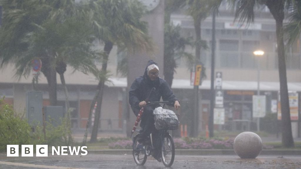
Japan storm: Millions told to evacuate as Typhoon Nanmadol makes landfall​


One of the biggest typhoons ever to strike Japan has made landfall on the southern island of Kyushu.

Typhoon Nanmadol has brought winds of at least 180 km/h (112mph) and some areas could see 500mm (20 inches) of rainfall over Sunday and Monday.

At least four million people have been told to evacuate their homes.

Extensive flooding and landslides are expected, while bullet train services, ferries, and hundreds of flights have been cancelled.
The typhoon made landfall near the city of Kagoshima, on the southern tip of Kyushu, on Sunday morning.

Kyushu is the southernmost of the four islands that make up the main body of Japan and has a population of more than 13 million people.

The #Typhoon #Nanmadol hits #Kyushu Island Japan with winds of 150km/h (category 1) Heavy #rain, #flooding and #landslides are forecast.
 
▪︎Guatemala

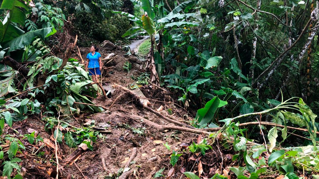
Tragic figure of 43 deaths due to severe rains in Guatemala in 2022

According to data provided by the National Coordinator for Disaster Reduction (Conred) of Guatemala, at least 43 deaths have been reported this year as a result of heavy rains.

According to Conred's General Rainy Season Report 2022, at least 10 thousand 937 people have been at risk due to the persistent floods that have affected more than three million Guatemalans.

At the same time, the prevention entity informed that there are currently 14 people sheltered for a total of 2,000 for the year. Meanwhile, 1,849 people have been assisted in the last few days.

Also on Tuesday, a hammock bridge collapsed in the village of Hacienda El Santo, in the department of Chiquimula; as well as the overflowing of the Samalá river in the municipality of San Andrés Villa Seca, Retalhuleu.

Conred registered the collapse of drains in the health post of the village of La Laguna Abajo in the municipality of La Unión, in the department of Zacapa. As well as flooding in the Centenario del Callejón Continuó Hotel El Alba, Suchitepéquez department.

At the same time, landslides have been reported in the perimeter wall of an elementary school in the village Timushan, in Zacapa; in the sector of Palo Alto, village Las Anonas, San José Pínula. And in the village Valentón 5 Arroyos, Unión Cantinil, Huehuetenango, where two houses were affected.


Torrential rains wreak havoc in Guatemala's Chuquimula province

▪︎Hurrricane Fiona update

Fiona became a powerful Category 3 hurricane on Tuesday as it heads toward the Turks and Caicos Islands after leaving two dead and causing widespread flooding and power outages in the Caribbean.

With maximum winds near 185 kilometers per hour, it is already causing cyclone conditions in the British overseas territory and is expected to strengthen further, the U.S. National Hurricane Center (NHC) said.

So far, Fiona has left two dead: a man whose house was swept away in the French overseas territory of Guadeloupe and another in the Dominican Republic, who died while felling a tree to protect himself from the storm.

Dominican Republic President Luis Abinader declared three eastern provinces as disaster zones: La Altagracia, home of the popular resort of Punta Cana; El Seibo and Hato Mayor.

Several roads were flooded or cut by falling trees or power poles around Punta Cana, where electricity was cut off, an AFP reporter reported on the scene.

Hurricane Fiona lashes the Turks and Caicos Islands with torrential rains and strong wind gusts.

Following the passage of Hurricane Fiona in the Dominican Republic, at least two people are reported dead in the country. The eastern zone is the most affected area of the territory, with more than 12,000 inhabitants displaced. Some 1.4 million people are without drinking water.

 
▪︎Hurricane Fiona update

Hurricane Fiona becomes a powerful Hurricane Category 4! in the Atlantic Basin.
-Winds 210 km/h-
After hitting and punishing #PuertoRico 🇷
#DominicanRepublic 🇩
The Turks and Caicos Islands 🇨
Now threatening Bermuda 🇧🇲
September 21/02:00h

Hurricane Fiona reaches powerful Category 4

"A turn toward the north-northeast with an increase in forward speed is expected by Thursday. On the forecast track, the center of Fiona will continue to move away from the Turks and Caicos today, and approach Bermuda late on Thursday," the National Hurricane Center said. "Fiona is a Category 4 hurricane on the Saffir-Simpson Hurricane Wind Scale. Additional strengthening is forecast through tonight. Some fluctuations in intensity are possible tonight and Thursday."

Increasing swells from Fiona will lead to a high risk of dangerous rip currents and hazardous boating conditions over the east central Florida coastal waters into late week and through the weekend.
 
▪︎Mexico

A phenomenon never seen before in Guamúchil, Sinaloa was felt this Thursday afternoon, a tornado that split the city from the north to the south leaving different damages in its path.


Report of #tornado non-supercell this afternoon (18:10 local time) in Guamúchil, #Sinaloa. Significant damage and a trajectory from the center of the city towards the highway to Mocorito are reported.

Tornado surprises in Guamúchil, Sinaloa

Residents of Guamúchil, Sinaloa, were surprised by a tornado that formed in the downtown area of the city, leaving one person injured and material damage.

It was on Thursday afternoon, where social network users were able to capture on video the moment when the tornado began to form and advanced over the main streets of the city, causing material damage.

The coordinator of Civil Protection of Salvador Alvarado, José Espinoza, announced that material damages were reported in fallen trees and some failures in the city's wiring due to the strong wind.

However, he pointed out that an employee of a department store located in the center of the city was found to have been injured as a result of the events that took place, but was attended to in due course.

Around 6:20 p.m., the impressive tornado surprised the inhabitants of the town, who were congregated in the main square dedicated to Pedro Infante of said town due to a cultural fair.
 

Hurricane Fiona likely to be 'extreme weather event' as it barrels toward eastern Canada, forecasters warn​


Deadly Hurricane Fiona has weakened slightly to a Category 3 storm but is still packing forceful winds of 125 mph as it barrels toward Canada's Atlantic coast.

It's expected to bring hurricane conditions to the region Friday night, the National Hurricane Center said.

It's on track to be an "extreme weather event" in eastern Canada, threatening powerful winds, dangerous storm surge and about two months' worth of rainfall, forecasters with the Canadian Hurricane Centre warned Friday afternoon. And some parts, like the Canadian Maritimes, will likely begin feeling effects Friday evening, the centre said.

Officials in Canada's Nova Scotia and Prince Edward Island urged those in the storm's path to be on high alert and prepare for the impact of the hurricane, which has already claimed the lives of at least five people and shut off power for millions this week as it battered multiple Caribbean islands.

Fiona strengthened to a Category 4 storm early Wednesday over the Atlantic after passing the Turks and Caicos, and remained so until Friday afternoon.

The National Hurricane Center said in its 8 p.m. ET advisory the storm weakened slightly but still whipped hurricane-force winds extending more than 100 miles from its center and tropical storm-force winds extending more than 300 miles.

Its center was about 215 miles southeast of Halifax Friday night.

"Although gradual weakening is forecast during the next couple of days, Fiona is expected to be a powerful hurricane-force cyclone when it moves across Atlantic Canada," the center said.


Fiona will make landfall in eastern Nova Scotia Canada on Saturday morning and produce very heavy rains, severe winds and storm surges.
 

Trending content

Back
Top Bottom