Crazy Storm Weather and Lightning - Global

#StormAlex may bring potential winds exceeding 100km an-hour along the southern coast and a possible big chill.

The Depression #Alex , responsible for the first #tempête of the season tomorrow on south #Bretagne , will also cause a clear deterioration of conditions on Friday in the south-east of the country.


With the approach of the storm #Alex ,@meteofrance emits an orange alert this morning Dash symbol Strong winds: Morbihan, Côtes-d'Armor, Ille-et-Vilaine and Loire-Atlantique 🌧 Heavy rains: Finistère, Côte-d'Armor, Morbihan


Cosmic Rays Trigger Lightning

More than 4,200 flashes recorded on #AlpesMaritimes since this morning including 261 in Saint-Martin-Vésubie, 224 in Tende, 197 in Andon. Intense and continuous electrical activity under these #orages diluvians.http://keraunos.org/temps-reel/imp


RED SPRITES AND GREEN GHOSTS:
Christophe Suarez of Genoa, Italy, wasn't trying to photograph sprites when he pointed his camera at a distant thunderstorm on Sept. 10th. But this magnificent specimen was too big to miss:
sprites_strip.jpg

"I was shooting a thunderstorm across the Ligurian Sea almost 400 km away over the island of Corsica," says Suarez. "Suddenly this jellyfish sprite appeared!" Its red form stretched 100 km high, nearly touching the edge of space.

Note the slightly-green caps on top of the sprite. These are a newly discovered phenomenon called "Green Ghosts." When sprites intersect Earth's airglow layer 96-97 km high, they can excite oxygen atoms, producing an aurora-like glow. Green Ghosts were discovered just one year ago by Hank Schyma, a Houston Texas-based storm chaser better known to his fans as Pecos Hank. Only a handful of Green Ghosts have ever been photographed, so this is an area of cutting edge research.
 
Wow an interesting term for this weird weather phenomena, Ciclogénesis Explosiva.

Definitions of explosive cyclogenesis
noun
a phenomenon or process in which there is rapid and sustained falling of barometric pressure in the center of a low-pressure system, indicative of its strengthening into a powerful storm.

The storm #Alex It will go deeper tomorrow afternoon at 12h 17mb from 993mb to 977mb. This deepening makes it possible to be classified as #ciclogenesisexplosivaThe night from V to S the level of will be around 1200m in the Western Pyrenees More than 50cm above 2000m.


Oh my! This afternoon (10/02/2020), gale in the Plaza de Santo Domingo, in the city of #Murcia . The strong streaks of #vientoThey have caused many problems in the collection of the terraces of the establishments. Video:
@P_CaballeroG


Intempéries dans les Alpes-Maritimes : un millier de pompiers à la recherche des disparus​

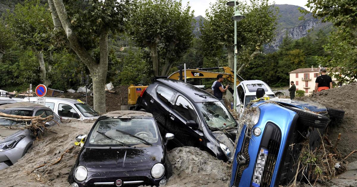
EN IMAGES - Selon le dernier bilan des autorités, huit personnes sont toujours portées disparues dans la Vallée de la Roya et dans la Vésubie et une dizaine d'autres sont «recherchées».

Par Le Figaro avec AFP
Publié il y a 2 heures

Le pont traversant la Vésubie à Roquebillière a été emporté. NICOLAS TUCAT / AFP
Près de 1000 pompiers sont mobilisés dimanche 4 octobre dans les Alpes-Maritimes frappées par des crues exceptionnelles, pour oeuvrer au rétablissement des voies de communication et à la recherche des personnes disparues, ont indiqué les pompiers à l'AFP. Vendredi, jusqu'à 500 millimètres de pluies sont tombés en quelques heures, «du jamais vu depuis l'installation des instruments de mesure», a dit le premier ministre Jean Castex, venu sur place.
À LIRE AUSSI : «J'ai tout perdu mais on est en vie»: des sinistrés des intempéries dans les Alpes-Maritimes relativisent
En Italie, deux personnes, dont un pompier, ont été retrouvées mortes dans des inondations à la frontière avec la France. Samedi soir, 21 personnes qui étaient portées disparues par les autorités italiennes ont été secourues du côté français des Alpes, près de Tende, dans l'arrière-pays niçois. Dans la matinée, un gendarme français porté disparu avait lui aussi été retrouvé sain et sauf.

À LIRE AUSSI : Intempéries dans les Alpes-Maritimes : un gendarme disparu retrouvé vivant
Selon le dernier bilan des autorités, huit personnes sont toujours portées disparues en France, dans la Vallée de la Roya et dans la Vésubie, depuis la nuit de vendredi à samedi, et une dizaine d'autres sont «recherchées», c'est-à-dire que «nous sommes sans nouvelle (d'elles)» a indiqué samedi soir Jean Castex qui s'est rendu à Nice.
Les dégâts sont graves des deux côtés de la frontière : de nombreux villages ont été dévastés par les eaux et les glissements de terrain, des routes et des ponts ont été endommagés ou détruits.

«Les recherches continuent bien sûr, avec des reconnaissances d'endroits isolées» auxquels les pompiers n'avaient pas encore accès dimanche matin, ont indiqué à l'AFP les pompiers des Alpes-Maritimes. «Il faut rétablir les voies de communication pour permettre l'accès des secours», ont-ils ajouté. 600 pompiers des Alpes-Maritimes restent à pied d'oeuvre, ainsi que les quelque 300 effectifs venus en renfort d'autres départements dès vendredi soir.

Villages ravagés​

A Roquebillière, à une cinquantaine de kilomètres au nord de Nice, deux personnes âgées ont été emportées par les flots dans l'effondrement de leur maison.


Dans les Alpes-Maritimes, une maison emportée par la force de la Vésubie
À Roquebillière, la maison de deux personnes âgées, qui s'étaient réfugiées sur le toit, est emportée par la Vésubie en crue, suite aux pluies diluviennes qui se sont abattues dans les Alpes-Maritimes.
Partager
Jouer
Activer le son

Heure actuelle 0:07
/
Durée 0h47
Chargé: 100,00%


Niveaux de qualité
Plein écran
« Les pompiers n'ayant pas assez de corde longue, et même avec nos cordes à nous on ne pouvait pas arriver à la maison, donc pour les sortir c'était trop tard, puis la maison a été emportée coup », a raconté à l'AFP un témoin de la scène, Patrick Theus.

Une maison détruite dans le village de Roquebillière. NICOLAS TUCAT / AFP
Les crues qualifiées d '« exceptionnelles » par Météo France ont ravagé des villages de la vallée de la Vésubie et de la vallée de la Roya, où des maisons ont été emportées par les flots, tandis que d'autres sont en péril, perchées au -dessus du vide. De nombreuses routes et ponts sont toujours coupés dimanche, et de ce fait des villages entiers sont isolés du monde.
Depuis samedi, l'armée et des centaines de secouristes sont proposés côté français pour rechercher les disparus et apporter par hélicoptère des moyens médicaux et de l'eau aux habitants isolés.
La rédaction vous conseille


HomeNewsCompany
Bad weather in the Alpes-Maritimes: a thousand firemen looking for the missing ones
IN PICTURES - According to the latest assessment of the authorities, eight people are still missing in the Roya Valley and in Vesubia and about ten others are "wanted".

By Le Figaro with AFP
Posted 2 hours ago
The bridge crossing the Vésubie River at Roquebillière was washed away.
The bridge crossing the Vésubie River in Roquebillière was washed away. NICOLAS TUCAT / AFP
Nearly 1,000 firefighters are mobilized Sunday, October 4 in the Alpes-Maritimes hit by exceptional floods, to work to restore communication routes and search for missing persons, the firefighters told AFP. Friday, up to 500 millimeters of rain fell in a few hours, "never seen since the installation of measuring instruments," said Prime Minister Jean Castex, who came on site.

TO READ ALSO: "I lost everything but we're alive": disaster victims of the bad weather in the Alpes-Maritimes put into perspective
In Italy, two people, including a firefighter, were found dead in floods on the border with France. On Saturday evening, 21 people who were reported missing by the Italian authorities were rescued on the French side of the Alps, near Tende, in the hinterland of Nice. In the morning, a missing French gendarme was also found safe and sound.

READ ALSO: Bad weather in the Alpes-Maritimes: missing gendarme found alive
According to the last balance sheet of the authorities, eight people are still missing in France, in the Valley of Roya and Vésubie, since the night of Friday to Saturday, and a dozen others are "wanted", that is to say that "we are without news (of them)" indicated Saturday evening Jean Castex who went to Nice.

The damage is serious on both sides of the border: many villages have been devastated by water and landslides, roads and bridges have been damaged or destroyed.

"The search continues of course, with reconnaissance of isolated places" to which firefighters had not yet had access on Sunday morning, the Alpes-Maritimes firefighters told AFP. "It is necessary to re-establish the communication channels to allow the access of the rescue services", they added. 600 fire departments of the Alpes-Maritimes remain at work, as well as the 300 or so personnel who came in reinforcement from other departments from Friday evening.

Ravaged villages
In Roquebillière, about 50 kilometers north of Nice, two elderly people were swept away by the waves in the collapse of their house.

Dans les Alpes-Maritimes, une maison a été emportée par la force de la Vésubie.
A Roquebillière, la maison de deux personnes âgées, réfugiées sur le toit, a été emportée par les inondations de la Vésubie, suite aux fortes pluies qui sont tombées dans les Alpes-Maritimes.
Partager
Activer le son
Heure actuelle
0:07
/
Durée
0:47

Niveaux de qualité
"Les pompiers n'avaient pas assez de corde longue, et même avec nos propres cordes, nous ne pouvions pas nous rendre à la maison, donc pour les faire sortir, il était trop tard, puis la maison a été emportée", un témoin de la scène, Patrick Theus, a déclaré à l'AFP.

Une maison détruite dans le village de Roquebillière.
Une maison détruite dans le village de Roquebillière. NICOLAS TUCAT / AFP
Les inondations qualifiées d '«exceptionnelles» par Météo France ont ravagé des villages des vallées de la Vésubie et de la Roya, où des maisons ont été emportées, tandis que d'autres sont en danger, perchées au-dessus du vide. De nombreuses routes et ponts sont encore coupés dimanche et, par conséquent, des villages entiers sont isolés du monde.

Depuis samedi, l'armée et des centaines de secouristes ont été déployés côté français pour rechercher les disparus et apporter des fournitures médicales et de l'eau aux habitants isolés par hélicoptère.

La rédaction vous conseille
Intempéries dans les Alpes-Maritimes: images avant / après des dégâts impressionnants

Traduit avec www.DeepL.com/Translator (version gratuite)
 
Wow an interesting term for this weird weather phenomena, Ciclogénesis Explosiva.

Definitions of explosive cyclogenesis


The storm #Alex It will go deeper tomorrow afternoon at 12h 17mb from 993mb to 977mb. This deepening makes it possible to be classified as #ciclogenesisexplosivaThe night from V to S the level of will be around 1200m in the Western Pyrenees More than 50cm above 2000m.


Oh my! This afternoon (10/02/2020), gale in the Plaza de Santo Domingo, in the city of #Murcia . The strong streaks of #vientoThey have caused many problems in the collection of the terraces of the establishments. Video:
@P_CaballeroG


My living room after hurricane Gamma!


You all know what this means…

That's right, indoor pool!! :cool2:

Here in Cancun we are all preparing for Delta as it will directly hit us tonight. Should be fun! ;-D
 
Should be fun!
Stay safe neema. That's a nice approach to the challenge.

#Delta it approaches the coast of Quintana Roo. Slightly weakened with winds of 215 km / h (still cat 4), it is located 220 km east-southeast of Cozumel. Extremely dangerous cyclone due to very intense winds, torrential rains and storm surge


Another good video from Adapt 2030:

Is the Frequency of our Planet Changing


So many electric changes are now manifesting visibly in Earth's skies that from this point forward human and animal life will be affected electromagnetically. Red sprites now forming feet, intense red aurora deep into the crack in our magnet field, birds by the thousands smashing into buildings from Philadelphia to NYC. Mars suddenly has clouds, which s only possible if electrical changes are happening in its crust. Signs in the skies.


Indeed. It seems the electrical nature of our weather, changing atmosphere and weakening magnetosphere is becoming ever more apparent:
 
This day registered 22.* Celsius (a dramatic jump), from One *C just a few days ago.

Now the weather fright train (named Storm Barbara), will bring another round of snow quite early this year.


Very wet week on the #Cévennes where a classic Cevennes episode in this season is planned. Little chance of seeing the sun there with continuous (weak to moderate) and lasting rains. A front will wave in the west, dry weather with wind in the east.

Storm Barbara is forecast to bring high winds to southwest France from Tuesday, while forecasters are also warning of sudden violent thunderstorms in the region.

The storm's arrival - a fortnight after Storm Alex wrought havoc in the southeast of the country - heralds the end of cold weather in the area that has been a hallmark of the month so far. According to Météo France, it has been the coldest October, since 1988.


Gusts of up to 150kph are predicted at higher altitudes in the Pyrénées as Storm Barbara sweeps up from Spain on Tuesday, according to La Chaîne Météo, while higher temperatures will mean the early snow that has fallen - which arrived about a month earlier than is typical - will melt quickly, prompting experts to warn of possible flooding.


Heavy rainfall is forecast over the Cévennes from Tuesday evening until late Thursday evening, or even into Friday, with up to two months' rainfall expected in just a few days. Despite the heavy downpour, "the risk of flooding seems to be relatively limited at the moment," according to La Chaîne Météo.


Tropical Depression Twenty-Eight has formed in the northwestern Caribbean Sea and is expected to be a rainfall threat to the Gulf Coast next week.
Tropical storm warnings have been issued for the western tip of Cuba, where tropical storm conditions are expected on Monday.

Tropical storm watches have been issued for the northeastern portion of Mexico's Yucatan Peninsula and for Cozumel, where tropical storm conditions are possible late Monday into early Tuesday.

The center of newly-formed T.D. 28 is located just west of the Cayman Islands with little motion since it formed Saturday evening. Showers and thunderstorms are spreading through the western Caribbean Sea and into the southeastern Gulf of Mexico.


There were crazy hail storms in South East Queensland this afternoon will hail stones up to 14cm. Roofs and cars damaged. A friends son from Springfield Lakes has two cars written off and tiles on the roof of his house broken and hail stones go through his shed roof.


In one place, hail stones went right through the ceiling of the house.

 
There were crazy hail storms in South East Queensland this afternoon will hail stones up to 14cm. Roofs and cars damaged. A friends son from Springfield Lakes has two cars written off and tiles on the roof of his house broken and hail stones go through his shed roof.

World's largest hail record may be challenged by exceptionally large 8+ inches hailstones that hit Tripoli, Libya on Oct 27


Earlier this week on Tuesday, Oct 27th , the capital of Libya, Tripoli was hit by an unprecedented severe supercell storm. It produced exceptionally large, *giant* hail, possibly more than 8 inches (20 cm) in diameter. The first reports indicate that hailstones could be one of the largest ever recorded on Earth!

Such hail size would definitely fit into the world's Top 3 giant hailstone events reported globally. Besides the Vivian (south Dakota) hailstorm from 2010 and the so-called 'gargantuan' hailstorm in Argentina in 2018.


It is reminding me more and more of this scene from The Day After Tomorrow.


Remember what the Cs said:

21 June 2014 said:
A: Remember "Day After Tomorrow" and the comments we made about the coming global superstorm some "time" ago. You are presently witnessing many of the things that will intensify as time goes forward. Ain't it awesome?!!
 
Talk about things that intensify: Super Typhoon Goni, Asia's most powerful typhoon this year, makes landfall in the Phillippines with maximum sustained winds of 225km/h (140mph) at Catanduanes island on Sunday at 04:50 local time (19:50 GMT Saturday)..

Almost a million people have been evacuated from their homes. Between 19 million and 31 million people could be affected, including those in danger zones, the disaster management agency said.

In a severe weather bulletin, the Philippine Atmospheric, Geophysical and Astronomical Services Adminstration (Pagasa) warned of "flooding (including flash floods), rain-induced landslides, and sediment-laden streamflows" in areas of Luzon, as well as the islands of Visayas and Mindanao.
"Within the next 12 hours, catastrophic violent winds and intense to torrential rainfall... will be experienced," it said.

"Evacuating people is more difficult at this time because of Covid-19," Bicol regional civil defence spokesman Alexis Naz told AFP.
The Philippines is hit by an average of 20 storms and typhoons a year. Some 22 people were killed last week when Typhoon Molave barrelled through the same region now braced for Goni.


For some, it was the wait of a lifetime. 8 photographers tell in an exceptional crossed account the night of the waterspouts, in Genoa, on September 7th. https://bit.ly/34MRKvT
Snip: 22-29 minute Read:
That night in early September 2020 will probably be remembered by storm enthusiasts. While instability had steadily raged in northern Italy for several weeks - generating supercells, waterspouts and tornadoes - the climax of this period would take place on the night of "September 6-7" in Genoa.

Dean Gill:
“Watching a nighttime waterspout or tornado illuminated by lightning is a childhood dream that dates back to the evening of September 11, 1970, near Venice, Italy. Just after dark, a violent tornado passed 200 meters from the house of my grandparents where I was staying. Hidden in the kitchen, I couldn't see him, just heard him. On the other hand, one of my aunts had been fortunate enough to observe the phenomenon as the whirlpool entered the Venetian lagoon, describing it as "a large funnel lit by lightning, at the foot of which swirled debris". This image remained imprinted somewhere in a corner of my brain. After several semi-unsuccessful attempts, such as the one of September 14, 2015 or the more recent one of September 2019, where I was able to capture the phenomenon far off Rimini in Italy, the night of September 6 to 7 was the night of liberation. "
Forecast time

Dean Gill:
“The day before the event, looking at the different model releases, it was clear that something very interesting was going to happen near Genoa. A line of convergence was to be set up between the sirocco (south-easterly wind) and the libeccio (south-westerly wind). The uncertainty lay in its location. Many models saw it far to the west, between Arenzano and Savona, which is rather unusual, while other models “plugged in” this line somewhere between Voltri and Genoa.
For my part, I made the decision to follow the second hypothesis with a probable placement on the heights of Crevari, west of Voltri. "

Baptiste Monterroso:
“The meteorological autumn begins, the Mediterranean is at its hottest on the Gulf of Genoa. With water surface temperatures (SST) reaching or even exceeding 26 ° C offshore, the slightest cold drop isolating itself on this gulf at this time of year almost always produces a spectacle worthy of its reputation. Genoa is a city used to stormy phenomena, often striking in its visual aesthetics combined with the presence of sometimes devastating phenomena: flash floods or other vortex phenomena are often part of the Genoese alchemy. And precisely, this night of September 6 to 7, an isolated cold drop should generate a strong zone of convergence at the level of Genoa, a situation typical of this season with east, south-east and south flows channeling into a funnel and shearing pile off the city. AROME's runs are therefore unequivocal. "


Back
Top Bottom