Thanks, everything went as expected.Stay safe neema.
I've never spent two years making a Monsoon film before, so this was a first. Part of it was wanting to put out the best possible film I could, but a good chunk of it was the fact our recent summer storm seasons have been subpar at best, with 2020 the worst I can remember. 2019 wasn't horrible, but there was about zero dust storms, with only a single haboob clip to salvage from that summer, so I wanted to wait until I had something more to add to it.
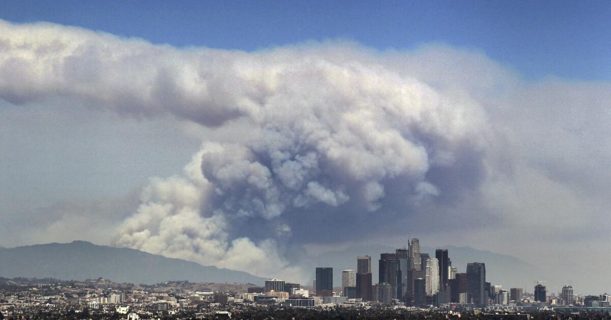
Luckily for me, August 16th, 2020 happened and we scored a fantastic haboob chase from Casa Grande to Gila Bend along Interstate 8. It was what I had been hoping and praying for to complete this film. That was the only legit haboob day of the past two years and I'm glad I was there for it! Not only for this film, but for the BBC and one of their upcoming projects I'm proud to be a part of!
Hurricane Iota Strengthens Into First Category 5 of 2020 Hurricane Season
Hurricane Iota has rapidly intensified into a rare Category 5, the first of the 2020 Atlantic hurricane season, as it heads for landfall in Central America, where it will bring potentially catastrophic rainfall flooding, mudslides, storm surge and damaging winds for the second time in two weeks.
Late Monday morning, Iota became only the second Category 5 hurricane on record in November and the record latest-in-season hurricane ever to reach that intensity in the Atlantic Basin. The 1932 Cuba hurricane reached Category 5 intensity from November 5-8.
...Iota will make landfall late Monday night along the coast of northern Nicaragua, in the same area Hurricane Eta made its Category 4 landfall on November 3.
...Regardless, Iota is likely to be a catastrophic hurricane for Central America.
This will be the first time on record two major hurricanes - Category 3 or stronger - made landfall in Nicaragua in the same hurricane season, much less only two weeks apart. NOAA's hurricane database only documented seven such Category 3-plus landfalls in Nicaragua prior from the mid-19th century through 2019.
...Iota is the 10th storm of the 2020 season to meet the criterion for rapid intensification. This tied 1995 for the most such rapid intensifiers in any single season since 1979, according to Tomer Burg, an atmospheric science Ph.D. student at the University of Oklahoma.
Iota's 160 mph maximum sustained winds on Monday morning makes it the strongest hurricane of the 2020 Atlantic season. It also topped Hurricane Lenny (1999) for the strongest Atlantic hurricane so late in the season, according to Dr. Phil Klotzbach, a tropical scientist at Colorado State University.
Extremely rare winter tornado hits Trieste, Italy
"Today, on Dec 7th, 2020, an intense supercell storm rolled across the North Adriatic Sea and produced a tornado that hit the Port of Trieste city, Italy in the evening hours. Severe weather with large hail and damaging winds blasted across the Slovenian coast, and also the city of Trieste itself," reports Severe Weather Europe.
"Call it rare, historic, or whatever possible, the event is extremely rare! Lets us repeat... it is December 7th, a winter month and the Adriatic Sea and the city of Trieste are located in central Europe."
Other recent rare or late-season tornadic activity includes:
- Large tornado hits Sakaka, Saudi Arabia - one of the largest ever documented in the region
- Confirmed tornado in Arlington, Texas causes some 'significant damage'
- Rare tornado outbreak hits northern parts of Turkish Cyprus causing widespread damage
- Rare late-season tornado confirmed in Ontario, Canada
- Rare tornado hits Antwerp, Belgium
A band of blustery showers will move southeastwards over the country early on Sunday night, turning to sleet and snow on higher ground in the north and east. This will be followed by scattered wintry showers. Lowest temperatures of 0 to 3 degrees occuring early in the night, rising later as west to northwesterly winds increase fresh to strong and gusty with gales or strong gales on Atlantic coasts.
TOMORROW - Monday 28th December
Monday will be blustery with widespread showers, wintry on higher ground, with a continued risk of hail. Highest temperatures of 4 to 7 degrees, coolest in the east, but feeling colder in fresh to strong and gusty northwesterly winds.
National Outlook
Summary: A cold and blustery end to 2020 is in store however it will remain largely dry away from Atlantic coast. There will be a continued risk of frost at night also.
Monday night: Staying cold and blustery with a mix of clear spells and scattered showers, turning wintry on higher ground. Lowest temperatures of 0 to 4 degrees in moderate to fresh northwesterly winds.
Tuesday: Another cold and blustery day on Tuesday, with sunny spells and scattered showers, mainly in the west and north and turning wintry at times. Afternoon temperatures of just 3 to 6 degrees in a moderate northwest to west wind.
Tuesday night: Scattered wintry showers will continue near coasts in the west and northwest on Tuesday night, remaining mostly dry elsewhere with clear spells, however there is a chance of more persistent rain in the southwest with sleet on high ground later in the night. It will be cold and frosty with lowest temperatures of -2 to +2 degrees in light to moderate westerly breezes.
Wednesday: Another cold day but mostly dry with sunny spells, although there will be further scattered showers near coasts in the west and north. Afternoon highest temperatures of 3 to 5 degrees in light west to northwest winds.
Wednesday night: Scattered showers will continue with the risk of some sleet on higher ground, elsewhere it will be partly cloudy with just the risk of an isolated passing shower. It will be another frosty night, lows of -2 to + 2 degrees in light to moderate west to northwest winds.
Thursday (New Year's Eve): A mix of sunny spells and showers, most frequent along western coasts. Highs of just 5 to 7 degrees in light to moderate northwest winds. Similar conditions will prevail for Thursday night with clears skies in the south and east bringing lowest temperatures of -2 to +2 degrees on light to moderate northwesterly breezes.
Friday (New Year's Day): Isolated showers in the east, mostly dry elsewhere with good sunny spells. Remaining cool however with highs of just 3 to 5 degrees in light northwesterly breezes.
Further outlook: Winds are set to ease further as high pressure builds in for the early days or 2021 however it will remain cool and mostly dry with frosts at night.
For some, it was the wait of a lifetime. 8 photographers tell in an exceptional crossed account the night of the waterspouts, in Genoa, on September 7th. https://bit.ly/34MRKvT
Having lived her life in Los Angeles, Morgan Andersen knows natural disasters all too well. In college, an earthquake shook her home hard. Her grandfather was affected by recent wildfires in neighboring Orange County.
“It’s just that constant reminder, ‘Oh yeah, we live somewhere where there’s natural disasters and they can strike at any time,’” said the 29-year-old marketing executive.
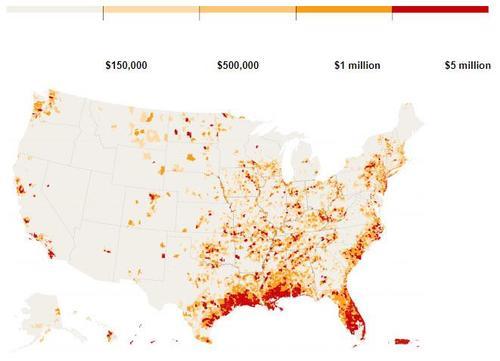
The Federal Emergency Management Agency has calculated the risk for every county in America for 18 types of natural disasters, including earthquakes, hurricanes, tornadoes, floods, volcanoes and even tsunamis. And of the nation’s more than 3,000 counties, Los Angeles County earned the highest ranking in the National Risk Index.
The way FEMA calculates the index spotlights places long known as danger spots, like Los Angeles. But there are also plenty of surprises.
For instance, East Coast cities such as New York and Philadelphia rank far higher on the risk for tornadoes than Tornado Alley stalwarts Oklahoma and Kansas.
And the county with the biggest coastal flood risk is one in Washington state that’s not on the ocean, although its river is tidal.
Those seeming oddities occur because FEMA’s index goes beyond how often disasters strike. It also considers how many people and how much property are in harm’s way, how vulnerable the population is socially and how well the area is able to bounce back — in other words, how bad the toll would be.
That results in a high risk assessment for big cities with lots of poor people and expensive property that are ill-prepared to be hit by once-in-a-generation disasters.
Take tornadoes. FEMA’s top five riskiest counties for twisters are two boroughs in New York City, Philadelphia, St. Louis and New Jersey’s Hudson County. The county that includes Oklahoma City — which has experienced more than 120 tornadoes since 1950, including one that killed 36 people in 1999 — ranks 120th.
The top five “are a low frequency, potentially high-consequence event because there’s a lot of property exposure in that area,” said Susan Cutter, director of the University of South Carolina Hazards & Vulnerability Research Institute, whose work FEMA relied on. “Therefore, a small tornado can create a large dollar loss.”
In New York, people are far less aware of the risk and less prepared — and that’s a problem, said Mike Grimm, a FEMA official who has specialized in risk management. The day before he said that, New York had a tornado watch. Days later, the National Weather Service tweeted that in 2020 several cities, mostly along the East Coast, had more tornadoes than Wichita, Kan.
In general, Oklahoma is twice as likely to get tornadoes as New York City, but the damage potential is much higher in New York because there are 20 times the people and nearly 20 times the property value at risk, FEMA officials said.
“It’s that risk perception that it won’t happen to me,” Grimm said. “Just because I haven’t seen it in my lifetime doesn’t mean it won’t happen.”
That sort of denial is especially true with frequent and costly flooding, he said. It’s also why only 4% of the population has federal flood insurance when about one-third may need it.
Disaster experts say people have to think about the big disaster that happens only a few times a lifetime at most but is devastating when it hits — Hurricane Katrina, Superstorm Sandy, the 2011 super outbreak of tornadoes, the 1906 San Francisco earthquake or a pandemic.
“We’re bad at taking seriously risks that happen only infrequently,” said David Ropeik, a retired Harvard risk communications lecturer and author of “How Risky Is It, Really?” “We simply don’t fear them as much as we fear things that are more present in our consciousness, more common. That’s practically disastrous with natural disasters.”
Something like FEMA’s new index “opens our eyes to the gaps between what we feel and what is,” Ropeik said.
FEMA’s top 10 riskiest places, in addition to Los Angeles, are three counties in the New York City area — Bronx, New York County (Manhattan) and Kings County (Brooklyn) — along with Miami, Philadelphia, Dallas, St. Louis and Southern California’s Riverside and San Bernardino counties.
By the same measurement, Loudoun County, a Washington, D.C., outer suburb, has the lowest risk of any county, according to FEMA. Three other Washington suburban counties rank among the lowest risks for larger counties, along with suburban Boston, Long Island, suburban Detroit and Pittsburgh.
Some of FEMA’s risk rankings by disaster type seem obvious. Miami has the highest risk for hurricanes, lightning, and river flooding. Hawaii County is tops in volcano risk and Honolulu County for tsunamis. Dallas ranks highest for hail, Philadelphia for heat waves and Riverside County for wildfires.
Himanshu Grover, a risk expert at the University of Washington, called FEMA’s effort “a good tool, a good start.” But he also said it had flaws, such as final scores that seem to downplay disaster frequency.
Ropeik added that the index didn’t seem to address how risks were changing due to climate change. FEMA officials said climate change showed up in flooding calculations and would probably be incorporated in future updates.
This new tool, based on calculations by 80 experts over six years, is about “educating homeowners and renters and communities to be more resilient,” Grimm said, adding that people shouldn’t move into or out of a county because of the risk rating.
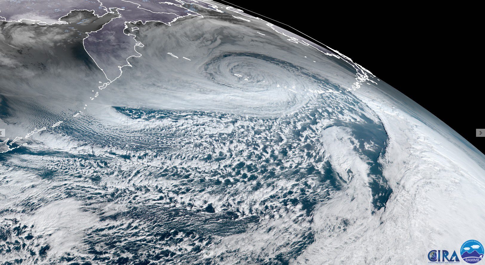
ANCHORAGE, Alaska (Reuters) – A Pacific storm of record proportions swept a remote stretch of Alaska’s Aleutian Islands chain on New Year’s Eve, battering a region used heavily by commercial shipping with hurricane-force winds and seas five stories high.
“It’s the most intense storm ever recorded in the North Pacific, excluding typhoons,” said Brian Brettschneider, a NOAA research scientist with the National Weather Service.
The center of what forecasters refer to as “bomb cyclone” was measured at a record-low barometric pressure of 921 millibars, equivalent to the eye of a Category 4 hurricane and the lowest documented over the Aleutians as far back as the 1950s, Brettschneider said.
The storm unleashed seas as high as 54 feet (16.5 meters) and winds topping 80 miles per hour (120 kph) – a force of Category 1 on the Saffir-Simpson hurricane wind scale – in the western Aleutians, the weather service said.
The storm was too far from large populated areas to pose a direct hazard to many people besides those traveling in the region by aircraft or vessel, Brettscheneider said.
The Aleutian island of Shemya with a small air station and a few personnel was in the epicenter of the storm, about 1,450 miles southwest of Anchorage, Alaska’s largest city. Most of the Aleutian Islands are uninhabited.
The waters, however, are heavily used by cargo ships traveling between Asia and North America. Thousands of vessels a year ply a shipping corridor known as the North Pacific Great Circle Route. The area is also important for commercial fishing.
The storm also caused some erosion of Bering Sea winter ice, already at some of its thinnest levels on record for this time of year, further disrupting a frozen landscape that walruses and some species of seals depend on.
“This may kind of set back ice formation,” Brettschneider said, adding that it would likely take five or six days for the winds to calm and for cold northern air to flow back in, allowing the Bering Sea to regain some ice. (Reporting by Yereth Rosen; Editing by Steve Gorman and Neil Fullick) (c) Copyright Thomson Reuters 2021.
Diosssss now I'm getting very, very nervous, but look what snowfall puts us on the Icon model from Friday morning it's hard to see a place of Cat without the snowflakes, bufffff we breathe and tomorrow we will do analysis but that would be very big , but that much !!!#meteo
Sure is looking a lot like a "global superstorm" in bits and pieces!
"Natural catastrophe losses in 2020 were significantly higher than in the previous year. Record numbers for many relevant hazards are a cause for concern, whether we are talking about the severe hurricane season, major wildfires or the series of thunderstorms in the US."
As natural disaster becomes more frequent, here are the US' zip codes that are subjected to the most disasters."An increasing number of heatwaves and droughts are fuelling wildfires, and severe tropical cyclones and thunderstorms are becoming more frequent," said Rauch.
OAKLAND, Calif. - A potent atmospheric river barreled through the Bay Area, bringing high winds that knocked out power and flash floods that caused evacuations from wildfire burn scars. Plus, heavy snow caused blizzard conditions in the Sierra Nevada.
However, despite all the worry, there was no major damage, other than a few trees coming down and disruptions to people's lives because the power went out.
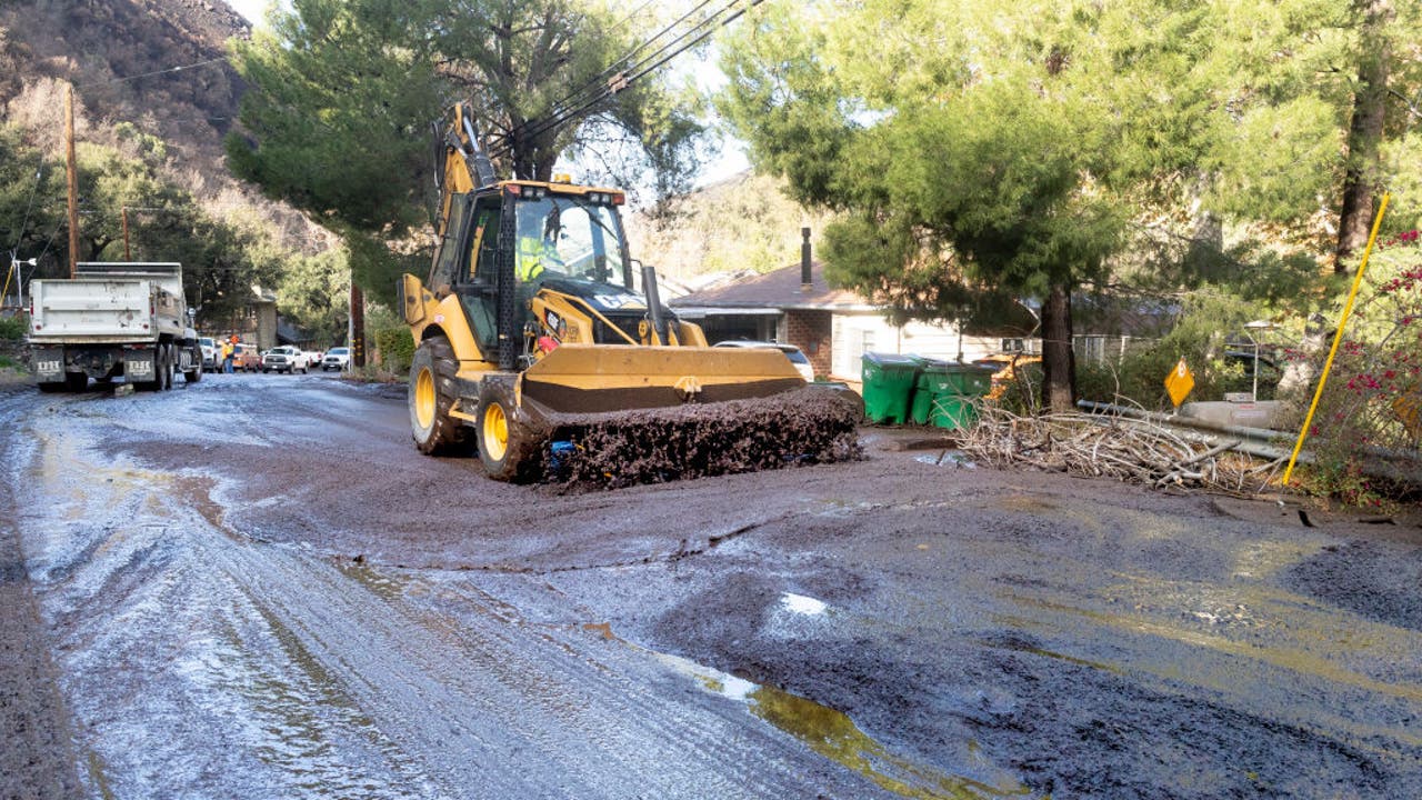
Thousands of residents in Santa Cruz and San Mateo counties were hit the hardest as they live in areas by a complex of wildfires ignited by lightning last August. The state Office of Emergency Services positioned strike teams and task forces in five counties. Officials feared the heavy rains would cause mudslides. However, by Wednesday morning, there were no immediate reports of damage.
Before the storm hit, deputies went door-to-door in the evacuation zones and tried to find people staying in evacuation areas who may not have access to phone service and emergency notifications. Those residents who didn’t evacuate were asked by deputies to sign a refusal waiver, officials said.
People in San Jose's Willow Glen were worried about flooding along the Guadalupe River, too. City crews braced for a busy night. They staffed up overnight to respond to downed trees, downed power lines and localized flooding. Residents went out to get sand bags.
City workers spent most of Tuesday evening going door-to-door, alerting hundreds of residents living near the river of possible rising waters. However, by Wednesday morning, there was no immediate word of any damage or flooding reported.
In San Franciso, there was standing water on many of the streets including Gough Street heading toward the freeway.
In the North Bay, residents also braced for the worst as heavy wind and rain, brought on by a winter storm, swept through the area. And the National Weather Service upgraded a flash flood watch to a warning as the atmospheric river arrived.
The wind knocked down a tree in Rohnert Park, causing some localized damaged there.
In the end, the wind proved to be more powerful than the rain. Power was knocked out to a peak of 38,000 PG&E numbers. However, by Wednesday morning, that number dropped to 27,000 customers.
The atmospheric river — a huge plume of moisture extending over the Pacific — was preceded by lighter rain before intensifying Tuesday evening, hitting the North Bay first, then spreading south to Santa Cruz, Monterey and Big Sur. Rare snow was reported in Sonoma and Napa counties north of San Francisco at elevations as low as 1,300 feet.
The National Weather Service issued a rare blizzard warning for Lake Tahoe and much of the Sierra, forecasting up to 6 feet of snow falling on upper elevations and winds in excess of 100 mph over ridgetops.
Describing it as a potential "life-threatening situation," the warning was to be in effect from 10 p.m. Tuesday through 4 a.m. Friday for the Tahoe area as far south as Mammoth Lakes, California.
A warning was also issued for widespread high avalanche danger on the eastern slopes of the Sierra because of heavy snow combining with wind from before dawn Wednesday through Friday morning.
Meanwhile, icy conditions in mountains north of Los Angeles shut vital Interstate 5 in Tejon Pass until early afternoon. Some truckers tried old narrow mountain roads around the closure and became stuck. In the same region, State Route 58 in Tehachapi Pass reopened at late morning after an overnight closure.
In the Sierra Nevada, the closure of Yosemite National Park was extended to at least Jan. 30. The park sustained heavy damage more than a week ago when it was battered by fierce winds that swept through California before the onset of the current storms.
While the upcoming storm could pose danger, it could help ease dry conditions that have left more than 95% of California experiencing drought.
The Associated Press contributed to this report.
TRUCKEE (CBS13) — Snow in the Sierra has local officials warning drivers to stay off the road.
“The storm is going to be intense. High winds is what’s predicted and those aren’t conditions you should be driving in,” California Highway Patrol officer Seth Jennings said.
Jennings insists tourists think twice before trekking to Truckee.
“Visibility will be zero at times. If we can’t see where we’re going or it’s not passable for us to get there, then we have to take our time to get to people,” Jennings said.
Truckee locals were filling up their gas tanks and packing grocery stores, preparing to hunker down Tuesday afternoon.
“Burgers, chicken patties, pizza,” Colby Banks said.Police Release Photos Of Person Of Interest In Sacramento Prowler Cases
“It could really get you in trouble,” Fritz Renner, who’s lived in Truckee for 20 years, said.
Renner says even he’s nervous with whiteout conditions headed for the Sierra.
“You don’t see those kind of warnings very often. National weather service 8ft? That’s as bad as it gets,” Renner said.
But the first big blizzard of the winter isn’t all bad.
“Favorite part of the snow is skiing fresh powder,” Truckee resident, Glenda Granucci, said.
“It’s great that we’re getting precipitation California needs the snowpack. But while it is storming we recommend no one drive through the area,” Officer Jennings said.
Chain controls will be required for vehicles without four-wheel drive and snow tires.
Get the most out of CBS13’s weather coverage: