You are using an out of date browser. It may not display this or other websites correctly.
You should upgrade or use an alternative browser.
You should upgrade or use an alternative browser.
Earthquakes around the world
- Thread starter pescado
- Start date
WORLDWIDE EARTHQUAKE REPORT SEPTEMBER 14_2023
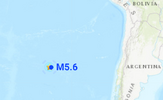
● M 5.6 - southeast of Easter Island
2023-09-14 22:51:26 (UTC)
36.466°S 98.049°W. 10.0 km depth
USGS earthquake alert

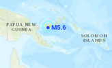
● M 5.6 - 5 km E of Kandrian, Papua New Guinea
2023-09-14 19:58:44 (UTC)
6.197°S 149.597°E. 62.2 km depth
USGS earthquake alert
● M 5.0 - New Britain region, Papua New Guinea
2023-09-14 23:15:31 (UTC)
6.543°S 149.467°E. 10.0 km depth
USGS earthquake alert

● M 5.2 - 7 km S of El Cantón de San Pablo, Colombia
2023-09-14 14:25:06 (UTC)
5.273°N 76.732°W. 7.2 km depth
USGS earthquake alert
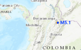
● M 5.1 - northern Colombia
2023-09-14 07:01:04 (UTC)
6.837°N 73.032°W. 151.3 km depth
USGS earthquake alert

● Summary
Seismic activity level has been at moderate levels in the last 24 hours. This is the last chart posted by Volcanodiscovery at 23:10 UTC on September 14 Global seismic activity chart

Volcanodiscovery earthquake report 24h
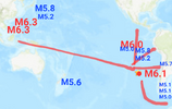
The Mercury, Sun, Mars planetary alignment coincided with a seismic cluster of M5+ earthquakes. Most of these were due to the movement of energy now towards South America. This new sequence started with the M6.3 earthquake in the Philippines and the first impact occurred in West Chile Rise with an M6.1 earthquake, from here the energy will be distributed towards the north of the continent and towards the South Sandwich Islands. In fact, Colombia registered today two 5+ magnitude earthquakes while Easter Island registered an M5.6.
With the movement of energy to the north, it is possible that Colombia, Nicaragua, Panama and Costa Rica will have an M5.5 or in the worst case M6+ earthquake. On the Caribbean side, an M5+ earthquake could be expected, while for Central America and Mexico an M5+ and in the worst case M6+ earthquake could occur. Let's wait and see


With the movement of energy to the north, it is possible that Colombia, Nicaragua, Panama and Costa Rica will have an M5.5 or in the worst case M6+ earthquake. On the Caribbean side, an M5+ earthquake could be expected, while for Central America and Mexico an M5+ and in the worst case M6+ earthquake could occur. Let's wait and see
● M 5.6 - southeast of Easter Island
2023-09-14 22:51:26 (UTC)
36.466°S 98.049°W. 10.0 km depth
USGS earthquake alert
● M 5.6 - 5 km E of Kandrian, Papua New Guinea
2023-09-14 19:58:44 (UTC)
6.197°S 149.597°E. 62.2 km depth
USGS earthquake alert
● M 5.0 - New Britain region, Papua New Guinea
2023-09-14 23:15:31 (UTC)
6.543°S 149.467°E. 10.0 km depth
USGS earthquake alert
● M 5.2 - 7 km S of El Cantón de San Pablo, Colombia
2023-09-14 14:25:06 (UTC)
5.273°N 76.732°W. 7.2 km depth
USGS earthquake alert
● M 5.1 - northern Colombia
2023-09-14 07:01:04 (UTC)
6.837°N 73.032°W. 151.3 km depth
USGS earthquake alert
Other light earthquakes were recorded in Tamarindo, Costa Rica (M4.5) Morocco (M4.6) southeast of Easter Island (M4.9) Falls City, Texas (M4.0) Santa Rosalía, Mexico (M4.0) Chaucingo, Mexico (M4.0) Pope-Vannoy Landing, Alaska (M4.0)
● Summary
Seismic activity level has been at moderate levels in the last 24 hours. This is the last chart posted by Volcanodiscovery at 23:10 UTC on September 14 Global seismic activity chart
- 5 quakes above magnitude 5
- 32 quakes between magnitude 4 and 5
- 100 quakes between magnitude 3 and 4
- 228 quakes between magnitude 2 and 3
- 603 quakes below magnitude 2 that people normally don't feel.
Volcanodiscovery earthquake report 24h
Attachments
WORLDWIDE EARTHQUAKE REPORT SEPTEMBER 15_2023


● M 5.7 - 121 km W of Copiapó, Chile
2023-09-15 18:07:39 (UTC)
27.325°S 71.554°W. 4.9 km depth
USGS earthquake alert

● M 5.1 - South Sandwich Islands region
2023-09-14 23:51:27 (UTC)
57.945°S 25.207°W. 58.5 km depth
USGS earthquake alert
● M 5.1 - South Sandwich Islands region
2023-09-15 02:37:46 (UTC)
60.783°S 23.638°W. 10.0 km depth
USGS earthquake alert
● M 5.0 - South Sandwich Islands region
2023-09-15 09:30:02 (UTC)
60.437°S 25.881°W. 10.0 km depth
USGS earthquake alert

● M 5.1 - Kermadec Islands, New Zealand
2023-09-15 13:02:25 (UTC)
30.128°S 177.784°W. 35.5 km depth
USGS earthquake alert

● M 5.0 - 121 km WNW of Ternate, Indonesia
2023-09-15 18:16:01 (UTC)
1.140°N 126.350°E. 12.4 km depth
USGS earthquake alert

Other light earthquakes were recorded in Tarapaca, Chile (M4.5) Saipan, Northern Mariana Islands (M4.7) Hualien City, Taiwan (M4.9) Tonga (M4.9) Tomioka, Japan (M4.6)
● Earthquake Forecast
● Summary
Seismic activity level has been at moderate levels in the last 24 hours. This is the last chart posted by Volcanodiscovery at 23:28 UTC on September 15 Global seismic activity chart

Volcanodiscovery earthquake report 24h
As expected, the energy from the M6.1 West Chile Rise earthquake moved toward central Chile and the southern Sandwich Islands. A cluster of three M5+ earthquakes shook the islands which could mean good news for Chile as seismic activity in the Sandwich Islands releases pressure for central and southern Chile.
● M 5.7 - 121 km W of Copiapó, Chile
2023-09-15 18:07:39 (UTC)
27.325°S 71.554°W. 4.9 km depth
USGS earthquake alert
● M 5.1 - South Sandwich Islands region
2023-09-14 23:51:27 (UTC)
57.945°S 25.207°W. 58.5 km depth
USGS earthquake alert
● M 5.1 - South Sandwich Islands region
2023-09-15 02:37:46 (UTC)
60.783°S 23.638°W. 10.0 km depth
USGS earthquake alert
● M 5.0 - South Sandwich Islands region
2023-09-15 09:30:02 (UTC)
60.437°S 25.881°W. 10.0 km depth
USGS earthquake alert
● M 5.1 - Kermadec Islands, New Zealand
2023-09-15 13:02:25 (UTC)
30.128°S 177.784°W. 35.5 km depth
USGS earthquake alert
● M 5.0 - 121 km WNW of Ternate, Indonesia
2023-09-15 18:16:01 (UTC)
1.140°N 126.350°E. 12.4 km depth
USGS earthquake alert
Other light earthquakes were recorded in Tarapaca, Chile (M4.5) Saipan, Northern Mariana Islands (M4.7) Hualien City, Taiwan (M4.9) Tonga (M4.9) Tomioka, Japan (M4.6)
● Earthquake Forecast
Updated 14 September 2023, 08:05 UTC. Some clustering of stronger earthquakes may occur from approximately 15 to 17 September, but it may not be much. More critical will be from 19 to 21 September when seismic activity can potentially reach higher 6 to 7 magnitude. SSGEOS
● Summary
Seismic activity level has been at moderate levels in the last 24 hours. This is the last chart posted by Volcanodiscovery at 23:28 UTC on September 15 Global seismic activity chart
- 6 quakes above magnitude 5
- 38 quakes between magnitude 4 and 5
- 111 quakes between magnitude 3 and 4
- 216 quakes between magnitude 2 and 3
- 595 quakes below magnitude 2 that people normally don't feel.
Volcanodiscovery earthquake report 24h
WORLDWIDE EARTHQUAKE REPORT SEPTEMBER 16_2023
● M 5.2 Bay of Plenty, New Zealand,.
2023-09-16 12:10:03 (UTC)
33.23874°S 179.09851°W. 100 km depth
GEONET earthquake alert
● M 5.0 - Kermadec Islands, New Zealand
2023-09-16 02:01:48 (UTC)
30.726°S 178.424°W. 10.0 km depth
USGS earthquake alert

● M 5.1 - Mid-Indian Ridge
2023-09-16 13:47:56 (UTC)
13.706°S 66.258°E. 10.0 km depth
USGS earthquake alert

● M 5.1 Southeast of Easter Island
2023-09-16 19:14:15.3 (UTC)
89.11°W 41.07°S. 10.0 km depth
GFZ earthquake alert

● M 5.0 - South Sandwich Islands region
2023-09-16 17:31:10 (UTC)
57.901°S 24.980°W. 25.6 km depth
USGS earthquake alert

● M 5.0 - 92 km ENE of Fef, Indonesia
2023-09-16 21:17:39 (UTC)
0.499°S 133.200°E. 10.0 km depth
USGS earthquake alert

● M 4.6 - 123 km NW of Türkmenbaşy, Turkmenistan
2023-09-16 22:51:24 (UTC)
40.792°N 51.906°E. 10.0 km depth
USGS earthquake alert

Pagar Alam, Indonesia (M4.8) Papua New Guinea (M4.9) Sarangani, Philippines (M4.9) Cepitá, Colombia (M4.9) Kuril Islands (M4.5) Sola, Vanuatu (M4.7) off the coast of Chiapas, Mexico (M4.2)
● Summary
Seismic activity level has been at moderate levels in the last 24 hours. This is the last chart posted by Volcanodiscovery at 22:51 UTC on September 16 Global seismic activity chart

Volcanodiscovery earthquake report 24h
Seismic activity was moderate in the past 24 hours. The highest magnitude event was recorded at the Bay of Plenty with a record of 5.2. This event was only reported by GFZ. On the other hand, seismic activity continues in West Chile Rise very close to the Easter Island as well as in the South Sandwich Islands. According to analyst Jesús Ramos this may result in a strong earthquake that at worst would reach M7. According to the analyst the energy released in the South Sandwich Islands is not enough to rule out this scenario of a severe earthquake in Chile.
After the M6.3 earthquake in the Philippines there has been no response in regions such as Northern New Zealand, Fiji, Tonga, Indonesia, Japan or the Philippines. At least one M6.5 and in the worst case M7+ event will be recorded in these areas. On the American side, Mexico, Peru, Ecuador and Chile face the same scenario.
As for the geometries of September 16, Earth, Moon, Mars and Sun, Mercury, Jupiter were recorded. The next geometries will occur on September 19, according to SSGEOS the latter is the most critical.
● M 5.2 Bay of Plenty, New Zealand,.
2023-09-16 12:10:03 (UTC)
33.23874°S 179.09851°W. 100 km depth
GEONET earthquake alert
● M 5.0 - Kermadec Islands, New Zealand
2023-09-16 02:01:48 (UTC)
30.726°S 178.424°W. 10.0 km depth
USGS earthquake alert
● M 5.1 - Mid-Indian Ridge
2023-09-16 13:47:56 (UTC)
13.706°S 66.258°E. 10.0 km depth
USGS earthquake alert
● M 5.1 Southeast of Easter Island
2023-09-16 19:14:15.3 (UTC)
89.11°W 41.07°S. 10.0 km depth
GFZ earthquake alert
● M 5.0 - South Sandwich Islands region
2023-09-16 17:31:10 (UTC)
57.901°S 24.980°W. 25.6 km depth
USGS earthquake alert
● M 5.0 - 92 km ENE of Fef, Indonesia
2023-09-16 21:17:39 (UTC)
0.499°S 133.200°E. 10.0 km depth
USGS earthquake alert
● M 4.6 - 123 km NW of Türkmenbaşy, Turkmenistan
2023-09-16 22:51:24 (UTC)
40.792°N 51.906°E. 10.0 km depth
USGS earthquake alert
Pagar Alam, Indonesia (M4.8) Papua New Guinea (M4.9) Sarangani, Philippines (M4.9) Cepitá, Colombia (M4.9) Kuril Islands (M4.5) Sola, Vanuatu (M4.7) off the coast of Chiapas, Mexico (M4.2)
● Summary
Seismic activity level has been at moderate levels in the last 24 hours. This is the last chart posted by Volcanodiscovery at 22:51 UTC on September 16 Global seismic activity chart
- 6 quakes above magnitude 5
- 27 quakes between magnitude 4 and 5
- 106 quakes between magnitude 3 and 4
- 205 quakes between magnitude 2 and 3
- 446 quakes below magnitude 2 that people normally don't feel.
Volcanodiscovery earthquake report 24h
Last week saw 3 M6, with the highest being a M6.3 in the Philippines.Last week saw 4 M6 earthquakes with the highest being the M6.8 in Morocco.
In the usual area, there was 1 out of 105 earthquakes worldwide equal to or greater than 4.5 and 1479 out of 1912 quakes of all sizes.
Percentage: 77.4%
In the usual area, there were 3 out of 91 earthquakes worldwide equal to or greater than 4.5 and 1395 out of 1696 quakes of all sizes.
Percentage: 82.3%
Strong mag. 5.6 earthquake - North Pacific Ocean, 292 km west of Vernon, Regional District of Mount Waddington, British Columbia, Canada, on Sunday, Sep 17, 2023 at 2:28 am (GMT -9)
M 5.6 - 228 km W of Port McNeill, Canada
2023-09-17 11:28:11 (UTC)
50.796°N 130.299°W. 10.0 km depth
USGS earthquake alert
Estimated energy release equivalent to 3788 tons of TNT
Data for the same earthquake reported by different agencies
Volcanodiscovery
M 5.6 - 228 km W of Port McNeill, Canada
2023-09-17 11:28:11 (UTC)
50.796°N 130.299°W. 10.0 km depth
USGS earthquake alert
Estimated energy release equivalent to 3788 tons of TNT
Data for the same earthquake reported by different agencies
| Mag. | Depth | Location | Source |
| 5.6 | 10 km | 228 Km W of Port McNeill, Canada | USGS |
| 5.6 | 10 km | Vancouver Island, Canada Region | IRIS |
| 5.5 | 10 km | Vancouver Island, Canada Region | GFZ |
| 5.6 | 10 km | Canada: Haida Gwaii Region | Raspberry Shake |
| 5.1 | 10 km | Canada: Near Vancouver | RENASS |
| 5.5 | 10 km | Vancouver Island, Canada Region | GeoAu |
WORLDWIDE EARTHQUAKE REPORT SEPTEMBER 17_2023


● M 5.1 South Sandwich Islands
2023-09-17 22:54:35 (UTC)
55.97°S 27.09°W. 10.0 km depth
GFZ earthquake alert

● M 5.0 - 140 km W of Lebu, Chile
2023-09-17 02:18:05 (UTC)
37.704°S 75.238°W. 10.0 km depth
USGS earthquake alert

● M 5.0 - 54 km N of La Serena, Chile
2023-09-17 04:01:46 (UTC)
29.419°S 71.312°W. 40.7 km depth
USGS earthquake alert

● M 5.0 - 74 km WNW of Kirakira, Solomon Islands
2023-09-17 11:54:00 (UTC)
10.140°S 161.323°E. 93.3 km depth
USGS earthquake alert

● Summary
Seismic activity level has been at moderate levels in the last 24 hours. This is the last chart posted by Volcanodiscovery at 23:01 UTC on September 17 Global seismic activity chart

Volcanodiscovery earthquake report 24h
Seismic activity was moderate in the past 24 hours. The highest magnitude event was recorded in Port McNeill Canada with a magnitude 5.6 however, the earthquakes in northern and southern Chile and the cluster in the Sandwich Islands is something to watch for a possible major event. As seen in the SSGI graph since September 13, there has been no response to the M6.1 West Chile Rise earthquake and no response to the M6.3 earthquake in the Philippines.
● M 5.6 - 228 km W of Port McNeill, Canada
2023-09-17 11:28:11 (UTC)
● M 5.1 South Sandwich Islands
2023-09-17 22:54:35 (UTC)
55.97°S 27.09°W. 10.0 km depth
GFZ earthquake alert
● M 5.0 - 140 km W of Lebu, Chile
2023-09-17 02:18:05 (UTC)
37.704°S 75.238°W. 10.0 km depth
USGS earthquake alert
● M 5.0 - 54 km N of La Serena, Chile
2023-09-17 04:01:46 (UTC)
29.419°S 71.312°W. 40.7 km depth
USGS earthquake alert
● M 5.0 - 74 km WNW of Kirakira, Solomon Islands
2023-09-17 11:54:00 (UTC)
10.140°S 161.323°E. 93.3 km depth
USGS earthquake alert
● Summary
Seismic activity level has been at moderate levels in the last 24 hours. This is the last chart posted by Volcanodiscovery at 23:01 UTC on September 17 Global seismic activity chart
- 5 quakes above magnitude 5
- 32 quakes between magnitude 4 and 5
- 104 quakes between magnitude 3 and 4
- 185 quakes between magnitude 2 and 3
- 403 quakes below magnitude 2 that people normally don't feel.
Volcanodiscovery earthquake report 24h
Strong earthquake hits 15 km southwest of Imola, Italy
● M 5.1 - northern Italy
2023-09-18 03:10:15 (UTC)
44.037°N 11.665°E
10.0 km depth
USGS earthquake alert

Data for the same earthquake reported by different agencies
Volcanodiscovery
● M 5.1 - northern Italy
2023-09-18 03:10:15 (UTC)
44.037°N 11.665°E
10.0 km depth
USGS earthquake alert
Data for the same earthquake reported by different agencies
| Mag. | Depth | Location | Source |
| 4.8 | 8.4 km | Italy: 3 Km SW Marradi (FI) | INGV |
| 5.2 | 5 km | Italy: Near Florence | RENASS |
| 5.1 | 10 km | Northern Italy | Raspberry Shake |
| 4.8 | 5 km | Northern Italy | SSS |
| 4.9 | 10 km | Northern Italy | GFZ |
| 5.1 | 10 km | Northern Italy | USGS |
| 5.1 | 10 km | Northern Italy | IRIS |
| 5.1 | 10 km | Northern Italy | GeoAu |
Volcanodiscovery
Strong earthquake in Japan
M 6.3 - 180 km N of Hirara, Japan
2023-09-18 13:21:23 (UTC)26.434°N 125.303°E183.5 km depth
USGS earthquake alert
Estimated energy release equivalent to 42671 tons of TNT or 2.7 atomic bombs.
M 6.3 - 180 km N of Hirara, Japan
2023-09-18 13:21:23 (UTC)26.434°N 125.303°E183.5 km depth
USGS earthquake alert
Estimated energy release equivalent to 42671 tons of TNT or 2.7 atomic bombs.
WORLDWIDE EARTHQUAKE REPORT SEPTEMBER 18_2023

So far, no significant seismic response has been recorded to the eastern Pacific Ocean.

● M 5.5 - 19 km NE of Onagawa Chō, Japan
2023-09-18 19:33:04 (UTC)
38.559°N 141.624°E. 64.4 km depth
USGS earthquake alert

● Summary
Seismic activity level has been at moderate levels in the last 24 hours. This is the last chart posted by Volcanodiscovery at 23:18 UTC on September 18 Global seismic activity chart

Volcanodiscovery earthquake report 24h
Seismic activity was at moderate levels in the past 24 hours. As expected and after the M6.3 earthquake in the Philippines a response of the same magnitude occurred in the China Sea 181 km north of Hirara, Miyakojima Shi, Okinawa, Japan.
After the M6.3 earthquake in the Philippines there has been no response in regions such as Northern New Zealand, Fiji, Tonga, Indonesia, Japan or the Philippines. At least one M6.5 and in the worst case M7+ event will be recorded in these areas
The earthquake in the China Sea occurs after the lunar geometry Earth, Moon, Mars and the planetary alignment Sun, Mercury, Jupiter but it is also worth considering that on September 13 an earthquake occurred in Indonesia at a depth of 648.7 km. According to Dutchsinse's depth to magnitude conversion chart for every 100 km of depth, 0.2 is added to the magnitude of the original earthquake. The possible earthquake will be shallower.
M0.2 * 6 = M1.2 + M5.1 = M6.3● M 5.1 - 101 km NW of Batang, Indonesia
2023-09-13 05:34:33 (UTC)
5.723°S 110.193°E. 648.7 km depth
M 6.3 - 180 km N of Hirara, Japan
2023-09-18 13:21:23 (UTC)
26.434°N 125.303°E. 183.5 km depth
USGS earthquake alert
So far, no significant seismic response has been recorded to the eastern Pacific Ocean.
● M 5.1 - northern Italy
2023-09-18 03:10:15 (UTC)
A magnitude-5.1 earthquake occurred in far eastern Tuscany Region at around 05:10 Sept. 18. The epicenter was about 6 km (4 miles) southeast of Marradi, Italy. The tremor occurred at a depth of about 10 km (6 miles), and light shaking was probably felt throughout Tuscany, Emilia-Romagna, Marche, Umbria, and southern Veneto regions in Italy and in San Marino. There have been no initial reports of damage or casualties;
 crisis24.garda.com
Italy: Magnitude-5.1 earthquake occurs in far eastern Tuscany Region at around 05:10 Sept. 18
Magnitude-5.1 earthquake occurs in far eastern Tuscany Region, Italy, at 05:10 Sept. 18. No immediate reports of damage or casualties.
● M 5.5 - 19 km NE of Onagawa Chō, Japan
2023-09-18 19:33:04 (UTC)
38.559°N 141.624°E. 64.4 km depth
USGS earthquake alert
● Summary
Seismic activity level has been at moderate levels in the last 24 hours. This is the last chart posted by Volcanodiscovery at 23:18 UTC on September 18 Global seismic activity chart
- 1 quake above magnitude 6
- 2 quakes between magnitude 5 and 6
- 35 quakes between magnitude 4 and 5
- 104 quakes between magnitude 3 and 4
- 249 quakes between magnitude 2 and 3
- 733 quakes below magnitude 2 that people normally don't feel.
Volcanodiscovery earthquake report 24h
Servicio Sismológico Nacional
The Santiago River fault: the great seismic threat to the Guadalajara Metropolitan Area
This earthquake is not as strange as it seems, is quite near to the metropolitan area of Guadalajara, Jalisco, MexicoMagnitude 3.5
2 km al northeast of TESISTAN, JAL.
2023-09-18 16:47:29 (Center Time)
Latitude: 20.81° Longitude: -103.49°
Profundidad: 8 km
The Santiago River fault: the great seismic threat to the Guadalajara Metropolitan Area
... Earthquakes originating on the coast have reached scales of up to 8.2, but with few aftereffects in the Metropolitan Zone. It has been the earthquakes generated in the geological faults of the Santiago River and in the area of Jocotepec that have generated the most devastating tremors for the city, some of up to 7.5 as the one that occurred in 1875 and destroyed San Cristobal de la Barranca and part of Zapopan.
On December 15, 2015, a process of activity began on this fault, which was reduced in March 2017. Even, the tremor recorded on May 11, 2016, of 4.8 degrees of intensity, was part of this cycle known as swarm. Activity resumed briefly between 2020 and 2021.
Pretty much where there had been a lot of building construction through the years.No plans for a short distance earthquake
Only Zapopan has developed a real estimation of the real impact in case of an earthquake generated in the Santiago River fault. The study was conducted by the Japanese specialist Kit Miyamoto and it indicates that the zone of greatest impact in the event of an earthquake on the Santiago River fault would be from the area of Puerta de Hierro to the Constitución neighborhood, passing through the center of Zapopan.
In the most catastrophic scenario, with a 7.7 earthquake, it is estimated that 29% of the buildings would be critically damaged and 31% would be severely damaged. The estimated death toll would be 2,100 and 17,000 injured. This does not include damage in other metropolitan municipalities.
WORLDWIDE EARTHQUAKE REPORT SEPTEMBER 19_2023


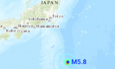
● M 5.8 - Izu Islands, Japan region
2023-09-19 06:22:36 (UTC)
30.979°N 141.975°E. 10.0 km depth
USGS earthquake alert
● M 5.2 - Izu Islands, Japan region
2023-09-19 22:17:47 (UTC)
30.996°N 141.993°E. 10.0 km depth
USGS earthquake alert

● M 5.6 - 43 km W of Methven, New Zealand
2023-09-19 21:14:49 (UTC)
43.706°S 171.118°E. 11.7 km depth
USGS earthquake alert

● M 4.6 - 6 km W of Rudna, Poland
2023-09-19 16:04:10 (UTC)
51.510°N 16.169°E. 5.0 km depth
USGS earthquake alert

● M 4.5 - 15 km SW of Westley, CA
2023-09-19 04:13:10 (UTC)
37.438°N 121.296°W. 3.5 km depth
USGS earthquake alert

Other light earthquakes were recorded in Vanuatu (M4.9) Khandūd, Afghanistan (M4.6) Hiroo, Japan (M4.6) Sumbawa region, Indonesia (M4.5) Sumatra, Indonesia (M4.9) Los Mogotes, Mexico (M4.2) Shikotan, Russia (M4.5) Merizo Village, Guam (M4.8)
● Summary
Seismic activity level has been at moderate levels in the last 24 hours. This is the last chart posted by Volcanodiscovery at 23:12 UTC on September 19 Global seismic activity chart

Volcanodiscovery earthquake report 24h
Seismic activity was at moderate levels in the past 24 hours. Two strong earthquakes have hit Izu Islands with magnitudes 5.8 and 5.2 These earthquakes are related to the northward movement of energy following the magnitude 6.3 earthquake in the China Sea. On the other hand a preliminary magnitude 6.0 earthquake hit in New Zealand which was adjusted to magnitude 5.6 This is also related to the movement of energy towards Central and South America, so a significant response can still be expected in the next few hours for southern Mexico, Central America, south-central Chile and the Sandwich Islands.
Finally, an atypical M4.6 earthquake occurred in Poland. This is possibly a response to the M5.1 earthquake in Northern Italy on September 18.
Finally, an atypical M4.6 earthquake occurred in Poland. This is possibly a response to the M5.1 earthquake in Northern Italy on September 18.
● M 5.8 - Izu Islands, Japan region
2023-09-19 06:22:36 (UTC)
30.979°N 141.975°E. 10.0 km depth
USGS earthquake alert
● M 5.2 - Izu Islands, Japan region
2023-09-19 22:17:47 (UTC)
30.996°N 141.993°E. 10.0 km depth
USGS earthquake alert
● M 5.6 - 43 km W of Methven, New Zealand
2023-09-19 21:14:49 (UTC)
43.706°S 171.118°E. 11.7 km depth
USGS earthquake alert
● M 4.6 - 6 km W of Rudna, Poland
2023-09-19 16:04:10 (UTC)
51.510°N 16.169°E. 5.0 km depth
USGS earthquake alert
● M 4.5 - 15 km SW of Westley, CA
2023-09-19 04:13:10 (UTC)
37.438°N 121.296°W. 3.5 km depth
USGS earthquake alert
Other light earthquakes were recorded in Vanuatu (M4.9) Khandūd, Afghanistan (M4.6) Hiroo, Japan (M4.6) Sumbawa region, Indonesia (M4.5) Sumatra, Indonesia (M4.9) Los Mogotes, Mexico (M4.2) Shikotan, Russia (M4.5) Merizo Village, Guam (M4.8)
● Summary
Seismic activity level has been at moderate levels in the last 24 hours. This is the last chart posted by Volcanodiscovery at 23:12 UTC on September 19 Global seismic activity chart
- 3 quakes between magnitude 5 and 6
- 42 quakes between magnitude 4 and 5
- 102 quakes between magnitude 3 and 4
- 249 quakes between magnitude 2 and 3
- 613 quakes below magnitude 2 that people normally don't feel.
Volcanodiscovery earthquake report 24h
Attachments
Strong earthquakes in Central East Pacific Rise
M 6.0 - central East Pacific Rise
2023-09-20 14:45:59 (UTC)
4.549°S 105.751°W. 10.0 km depth
USGS earthquake alert

Estimated energy release equivalent to 15080 tons of TNT or 0.9 atomic bombs
M 5.2 - central East Pacific Rise
2023-09-20 14:45:28 (UTC)
4.543°S 105.723°W
10.0 km depth
USGS earthquake alert
M 5.7 - central East Pacific Rise
2023-09-20 15:03:36 (UTC)
4.672°S 105.916°W
10.0 km depth
USGS earthquake alert
M 6.0 - central East Pacific Rise
2023-09-20 14:45:59 (UTC)
4.549°S 105.751°W. 10.0 km depth
USGS earthquake alert
Estimated energy release equivalent to 15080 tons of TNT or 0.9 atomic bombs
M 5.2 - central East Pacific Rise
2023-09-20 14:45:28 (UTC)
4.543°S 105.723°W
10.0 km depth
USGS earthquake alert
M 5.7 - central East Pacific Rise
2023-09-20 15:03:36 (UTC)
4.672°S 105.916°W
10.0 km depth
USGS earthquake alert
WORLDWIDE EARTHQUAKE REPORT SEPTEMBER 20_2023


● M 5.0 - South Pacific Ocean
2023-09-20 15:28:26 (UTC)
4.56°S 106.11°W. 10.0 km depth
GFZ earthquake alert

● M 5.8 - Prince Edward Islands region
2023-09-20 19:22:32 (UTC)
44.839°S 35.281°E. 7.6 km depth
USGS earthquake alert

● M 5.0 - Vanuatu
2023-09-20 09:32:31 (UTC)
14.696°S 167.965°E. 13.8 km depth
USGS earthquake alert
Other light earthquakes were recorded in West Chile Rise (M4.9) Hiroo, Japan (M4.7) Fiji region (M4.6 & 4.6) Dominican Republic (M4.4) Loyalty Islands (M4.6) San Antonio de los Cobres Argentina (M4.7) Kuril’sk, Russia (M4.6)
● Summary
Seismic activity level has been at moderate levels in the last 24 hours. This is the last chart posted by Volcanodiscovery at 23:15 UTC on September 20 Global seismic activity chart

Volcanodiscovery earthquake report 24h
A series of three earthquakes occurred in a span of just over 17 minutes in Central East Pacific Ocean. A M5.2 at 14:45:28 UTC a M6.0 at 14:45:59 UTC and a M5.7 at 15:03:36 UTC These events occurred after the Moon, Earth, Uranus lunar geometry. The magnetic precursor was recorded on Easter Island according to researcher Richard Cordaro (@rrichcord via X)
As expected, the energy of the M6.1 West Chile Rise earthquake is heading northward and it is possible that this energy will influence the Cocos Plate and the South American Plate seismic activity. According to Ka-Tet there are three possible points of impact in the next hours

Let's wait and see.
Let's wait and see.
● M 6.0 - central East Pacific Rise
2023-09-20 14:45:59 (UTC)
● M 5.2 - central East Pacific Rise
2023-09-20 14:45:28 (UTC)
● M 5.7 - central East Pacific Rise
2023-09-20 15:03:36 (UTC)
● M 5.0 - South Pacific Ocean
2023-09-20 15:28:26 (UTC)
4.56°S 106.11°W. 10.0 km depth
GFZ earthquake alert
● M 5.8 - Prince Edward Islands region
2023-09-20 19:22:32 (UTC)
44.839°S 35.281°E. 7.6 km depth
USGS earthquake alert
● M 5.0 - Vanuatu
2023-09-20 09:32:31 (UTC)
14.696°S 167.965°E. 13.8 km depth
USGS earthquake alert
Other light earthquakes were recorded in West Chile Rise (M4.9) Hiroo, Japan (M4.7) Fiji region (M4.6 & 4.6) Dominican Republic (M4.4) Loyalty Islands (M4.6) San Antonio de los Cobres Argentina (M4.7) Kuril’sk, Russia (M4.6)
● Summary
Seismic activity level has been at moderate levels in the last 24 hours. This is the last chart posted by Volcanodiscovery at 23:15 UTC on September 20 Global seismic activity chart
- 1 quake above magnitude 6
- 5 quakes between magnitude 5 and 6
- 39 quakes between magnitude 4 and 5
- 108 quakes between magnitude 3 and 4
- 251 quakes between magnitude 2 and 3
- 634 quakes below magnitude 2 that people normally don't feel.
Volcanodiscovery earthquake report 24h
Attachments
Trending content
-
Thread 'Coronavirus Pandemic: Apocalypse Now! Or exaggerated scare story?'
- wanderingthomas
Replies: 30K -
-

