Appollynon
Jedi Master
I thought I would post some of the research I have been doing as part of a Geology assignment I've been preparing to hand in for my college course. I'm doing this as I think some of the information may be interesting in light of the Fire and Ice article Laura has put together about a possible re-glaciation of the northern hemisphere. There is also some geologic information relating to the existence of tropical seas covering much of Britain in our distant past. I hope that this is not deemed a post of noise to distract, but I felt a compulsion to share some of my research as it gives a background into some of the glaciation events in the past in the UK, which likely affected a great deal of the northern hemisphere.
The geological story of Essex starts with rocks that are between 440 and 360 million years old. Dating from the Silurian and Devonian periods these rocks consist of hard, slaty shales, mudstones and sandstones and are over 300 metres below the surface. These rocks have been encountered in boreholes at many places in Essex and they represent a time in the distant past when the first animals were leaving the sea to colonise the land. Similar rocks can be seen at the surface in the Welsh Borderland.
Lying on top of these ancient rocks is the Gault, a marly clay from a muddy sea that dates from the middle of the Cretaceous period, about 100 million years ago. This means that, beneath Essex, there is a gap in the geological record that represents about 250 million years and includes the Triassic, Jurassic and early Cretaceous periods. After deposition of the Gault, sand spread into this sea to form a deposit called the Upper Greensand. At this time sea levels were rising leading to widespread flooding of the continents, the conditions under which the next rock was formed - the Chalk.
Chalk is effectively the starting point of our geological story as it is the oldest rock exposed at the surface in our county. Chalk also forms the foundations of the London Basin, a large basin-shaped structure beneath London and Essex. A great thickness of chalk forms the Chiltern Hills and their continuation as the hills of south Cambridgeshire; it then passes beneath central London and Essex and comes to the surface again as the North Downs of Surrey and Kent. This layer was originally horizontal, having been laid down as a limy mud on the floor of a tropical sea during the age of the dinosaurs; the folding occurring millions of years later as Britain was squeezed as a result of the African continent pushing into Europe and creating the Alps.
The chalk sea was in existence between 80 and 100 million years ago (during the Cretaceous period) and the purity of the chalk means that the water must have been crystal clear and the nearest land a considerable distance away; in fact it is thought that this sea may have covered most of northern Europe. The chalk sea was teeming with marine life such as molluscs, sponges, corals, sea urchins and fish, and at the top of the food chain were the mosasaurs, giant marine reptiles up to 10 metres long with a long body and tail, paddle-like limbs and heavy jaws armed with sharp, conical teeth. The smallest creatures were microscopic marine algae with protective shells called coccoliths, that accumulated on the sea floor in their billions. In fact it is now realised that chalk is almost entirely made up of these tiny fragmented shells which are only visible under an electron microscope.
The end of the Cretaceous period saw the extinction of the dinosaurs and the gradual disappearance of the chalk sea as sea level fell throughout the world. The next chapter in our story involved further inundations in later geological periods which deposited a great thickness of other rocks over the whole area. Much of Essex is therefore built on these younger rocks but the chalk is, of course, still present beneath the surface, in some cases as deep as 200 metres below ground level. In many cases the younger rocks consist of pebbles, sand or gravel, the remains of countless billions of flint nodules that have been removed from the chalk and ground down by erosion.
The environment of the region was now to change dramatically, leading to the deposition of the London Clay, a mud laid down on the floor of a subtropical sea some 50 million years ago.
The London Clay has yielded fine fossils of the sea's inhabitants such as molluscs, lobsters, crabs and sharks. There are also fossilised fruits, seeds and twigs which provide us with valuable information about the rain forest vegetation which existed on the land at this time.
Most remarkable of all are probably the fossil turtles and mammals from the workings of the Harwich cement industry in the 18th and 19th centuries. The cement was made from hard limestone nodules that occur in the clay and in one of these, in 1856, a workman found the skeleton of Hyracotherium (also known as Eohippus). Hyracotherium was the earliest ancestor of the horse and was no larger than a fox, with toes instead of hooves. This animal lived on the river banks and its bones must have been washed down a river into the sea. This was a time of rapid evolution of mammals following extinction of the dinosaurs.
London Clay fossils, particularly sharks' teeth, turn up all around the Essex coast but the most famous site is at Walton-on-the-Naze where the beach is very popular with collectors. The London Clay here is one of the reasons Walton is a site of international importance, mostly because in it are the best preserved bird fossils of Tertiary age to be found anywhere in the world. The London Clay also contains layers of volcanic ash which may have originated in Scotland where there were active volcanoes around this time.
THE ICE AGE - COOLING OF THE PLANET
The 'icing' on the county's geological 'cake' is the remarkable variety of deposits laid down during the Ice Age.
The story of the Ice Age starts around two million years ago. At this time the climate was probably not too dissimilar to the present day but the temperature had been slowly dropping for tens of millions of years, ever since the balmy, tropical days of the dinosaurs. The oldest Ice Age deposit in our region was laid down in a shallow sea and is known as the Chillesford Sand (part of the Norwich Crag Formation). This sand occurs at the base of gravel pits in north-west Essex but it is extremely difficult to date due to the absence of fossils for much of its thickness. Following deposition of the Chillesford Sand there is a very fragmentary record of our climate and landscape over the next million years or so. This period, which makes up most of the early part of the Ice Age, is poorly understood but some evidence has been preserved, thanks largely to an early route of the River Thames.
THE EARLY THAMES
During the early Ice Age the Thames flowed to the north of London, through north Essex, Suffolk and Norfolk and out across what is now the southern North Sea to become a tributary of the Rhine; the evidence for this being a substantial thickness of what is called Kesgrave Sands and Gravels which, remarkably, represents the actual bed of the river. These old Thames gravels contain a variety of unusual pebbles from as far away as North Wales, proving that, at that time, the Thames, and its tributaries, must have been a huge river system draining the Welsh mountains and bringing their characteristic volcanic rocks into the Thames basin
The gravels also contain large boulders of puddingstone and sarsens, which are very hard conglomerates and sandstones respectively. They are believed to be derived from pebble and sand seams in the Reading Beds, and which have subsequently become cemented by quartz. They have been put to use by man as ancient way markers at road junctions. The gravels have great commercial value and are worked in numerous gravel pits between Harlow, Chelmsford and Colchester, which was the route of the ancestral Thames at least 600,000 years ago.
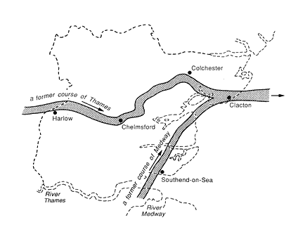
During this time the River Medway flowed north across east Essex to join the Thames near Clacton, leaving behind a ribbon of distinctive gravel which can be found between Burnham-on-Crouch and Bradwell-on-Sea. There were also other northward-flowing tributaries of the early Thames. Evidence of these are the patches of gravel that are found on the tops of the hills in south Essex, such as the Langdon Hills, Warley and High Beach in Epping Forest.
THE ANGLIAN ICE SHEET
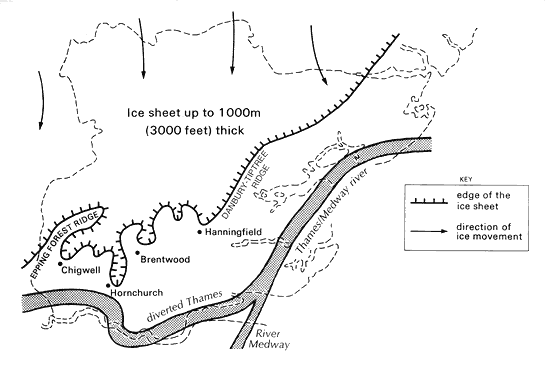
The regular pulses of climate change culminated in the Anglian glaciation, a severe cold stage about 450,000 years ago that allowed a great ice sheet to spread south into the region across the valley of the early Thames. A lobe of ice from this ice sheet blocked the Thames in the Vale of St. Albans causing a catastrophic change to the route of the river, diverting it south to its present position. Evidence for the existence of this ice sheet is a substantial thickness of boulder clay, or till, left behind by the ice as it ground southwards across the frozen landscape. The boulder clay, lying on top of the old Thames gravels, forms a distinct plateau over the north of Essex, now dissected by modern river valleys. Boulder clay can be found as far south as Hornchurch, which is known as the most southerly point in Britain that the ice penetrated during the whole of the Ice Age. The boulder clay contains rocks, called glacial erratics, that have been carried south by the ice, some of them from as far away as northern England and Scotland. The boulder clay also contains some fossils such as Jurassic ammonites and belemnites, brought here from the Midlands.
The landscape at this time is almost impossible for us to visualise. As the region was situated at the southern-most limit of the Anglian ice sheet, colossal volumes of melt water would have been continually released and the evidence for this is also preserved beneath our feet. In parts of East Anglia, boreholes have revealed deep, steep-sided valleys cut into the chalk bedrock and now completely filled with sand and gravel and hidden by a covering of boulder clay. Known as buried tunnel valleys or buried channels these remarkable natural features were formed beneath the ice sheet and were the main drainage routes for melt water. One of the best examples of a buried channel is the Cam-Stort Buried Channel that is present from Great Chesterford south as far as Bishops Stortford. You can't see it but in Newport it passes beneath your feet and is some 100 metres (300 feet) deep, almost half of this depth being below present sea level.
The Anglian glaciation was followed, about 400,000 years ago, by a warm stage traditionally called the Hoxnian interglacial. Neanderthals made their way north from Europe during this period taking advantage of the retreat of the ice. The Thames now flowed approximately along its present course but in the Southend area it turned north to Clacton along the old valley of the Medway laying down what is known as the Thames-Medway Gravels. These gravels are well exposed in the cliffs at Cudmore Grove Country Park in East Mersea. At Clacton, before the construction of the sea defences, these gravels yielded worked flints which are the earliest evidence of humans in Essex.
THE IPSWICHIAN INTERGLACIAL
The greatest and the warmest interglacial stage during the whole of the Ice Age was the Ipswichian, about 120,000 years ago. This period must have been warmer than the present day with monkeys, elephants and lions in southern England, the bones of which were found beneath Trafalgar Square in the 1950s as a result of building excavations. Downstream, the foreshore at East Mersea is currently one of the best sites of Ipswichian age in Britain. Here there are highly fossiliferous sediments called 'hippo gravels', so called because the hippopotamus was remarkably abundant in our region at this time, but curiously absent during almost all of the other interglacial stages. Fossils indicate that humans and also animals such as the horse were absent from Britain during the Ipswichian. Each interglacial stage has a distinctive fauna, presumably because, in each case, some animals were not quick enough to migrate north as the climate improved and were halted by the reappearance of the English Channel as sea level rose.
Following the warmth of the Ipswichian came the intense cold of the Devensian stage when an ice sheet again spread south but this time reaching no further than north Norfolk. Permafrost conditions gripped this region, providing home for only reindeer, arctic wolf and similar species.
Fossils of these animals have been found in a gravel pit at Great Totham and further west in the Lea valley.
Perhaps the most spectacular evidence of the Devensian cold stage is the network of ice wedge polygons that are occasionally revealed by crop marks in fields during hot, dry summers. Ice wedges are formed when the frozen ground shrinks and cracks during times of extreme cold. Each summer the cracks filled with water which then froze the following winter widening the cracks; a process that continued for thousands of years. At the end of the glacial stage the crack filled with debris preserving them as ice wedge casts, which are now revealed as crop marks.