[Sinkholes] creating a google map pinpointing all of them for 2012.

A farmer lost almost 25 tonnes of fish when a sinkhole appeared in his pond.

Chinese farmer loses 25 tons of fish after sinkhole appears in his pond
https://www.youtube.com/watch?v=IHSx1fERPe8

Published on Mar 30, 2016

A farmer in south China' s Guangxi Zhuang Autonomous Region suffered heavy losses after a sinkhole appeared in his fish pond.

The incident occurred in Guiping City at about 4 am on March 24, when water levels at the pond were seen falling at a dramatic rate.

At around 9am, the pond almost completely drained, and what' s left of the water in the pond was flowing down a gaping hole.

The owner of the farm says he lost about 25 tonnes of fish.

SOUNDBITE: YANG SHUANGXIAN, Owner of fish pond
"The water used to be 1.2 meters deep. I' ve been running the fish farm for five years and each year we would produce 30 tons of fish. This time, our direct loss is estimated to be 450,000 Yuan to 500,000 Yuan."

Local villagers say, this is not the first time for such sinkholes to appear in the area. They suspect that a nearby quarry is likely to blame for causing the incident.
 
Two sinkholes opened in Zagreb, Croatia. First one opened on April 5th, on major city avenue thus making traffic unberable.

_http://dnevnik.hr/vijesti/hrvatska/ogromna-rupa-otvorila-se-na-velikom-krizanju-u-zagrebu---432314.html

And one from today, much smaller but still its a sinkhole and its making a lot of people in the town scratching their heads.

_http://dnevnik.hr/vijesti/hrvatska/nova-rupa-u-zagrebu---432690.html
 
A car fell into a large sinkhole which opened up in Greenwich, in southeast London, early Thursday morning.

Huge Sinkhole Swallows Car in London
http://sputniknews.com/europe/20160512/1039505239/uk-sinkhole-car-fall.html

Metropolitan police received a call at 3:23am (local time), reporting of a sinkhole at Woodland Terrace in Greenwich. Officers found a dark blue family car, a seven-seater Vauxhall Zafira, peeping out of the hole twice as big as the vehicle.

​The car's unlucky owner, Ghazi Hassan, was just visiting his brother the night before and parked the car near Benefice of Charlton St. Thomas' Church.

Neighbors described being woken up by a sound like "thunder," but it was raining so much that it didn't surprise them much. According to police, nobody was injured in the incident.

And here:
Huge sinkhole swallows car in Greenwich (Video + Map)
http://www.telegraph.co.uk/news/2016/05/12/car-falls-down-sinkhole-in-greenwich/
 
Sinkhole stretching sidewalk to sidewalk near Canada’s parliament, and reports of gas leak, prompt evacuation of buildings.

Sinkhole spanning four-lane road swallows van in Ottawa (Video)
https://www.theguardian.com/world/2016/jun/08/sinkhole-ottawa-swallows-van

A sinkhole spanning the width of a four-lane road has opened in downtown Ottawa, swallowing a van, causing a gas leak and forcing the evacuation of several buildings in the heart of Canada’s capital.

The large sinkhole formed on Wednesday a few blocks away from parliament, in an area that was under construction and had been closed to all traffic save buses and taxis. There were no immediate reports of injuries.

Many on social media reported a “foul” smell of gas hanging over the area, prompting the hurried evacuation of a nearby shopping centre as well as a hotel and convention centre. Firefighters went door to door evacuating other businesses that sit along the busy stretch of road.

The gaping hole first appeared midmorning on Wednesday, with estimates putting it as large as five metres in diameter. Video taken from the scene showed dirty brown water gushing into a deep break in the paved road.

The sinkhole quickly grew to stretch from sidewalk to sidewalk of the four-lane road. As it widened, a parked dark van and a street lamp tumbled into the sinkhole.

The exact size of the sinkhole was being determined by engineers, who had been initially kept at bay by a ruptured water main and gas line, city officials said on Wednesday.

There was little indication of how long it would take to repair the damage, said Ottawa’s mayor, Jim Watson. “It’s a significant sinkhole in the downtown core. It has a major impact on our largest retail shopping centre, one of our major hotels as well as one of the busiest intersections and bus routes.”

Speculation was rife that the cavernous hole in the pavement was linked to a 1½-mile (2.5km) underground tunnel being dug for the city’s light rail transit system. Workers had been excavating in the area when the sinkhole began to form. All of them had made it out safely.

But Watson said it was too early to say whether the sinkhole was related to the underground drilling. “We can’t confirm whether the tunnel had any impact on the sinkhole or whether it was a water main break or whether it was a leak of some type that destabilised the soil.” City officials would, he hoped, be able to pinpoint the exact cause in the coming days.

In 2014, digging associated with the light rail transit system was linked to an eight-metre wide sinkhole that appeared just a few blocks over from the site of Wednesday’s sinkhole.
 
Two articles on the same issue (one is a quicker, easier read ;) ) about two huge sinkholes in Texas, possibly caused by industry years ago, but which are now thought to be growing and others areas are showing signs of activity too.


http://strangesounds.org/2016/06/two-infamous-sinkholes-expand-wink-kermit-texas-growing-wink-sinkholes-photo-video.html said:
Two infamous sinkholes are expanding and threatening residents of Wink and Kermit, Texas
By Strange Sounds -
Jun 14, 2016

Two giant infamous sinkholes sit between Wink and Kermit, Texas.

But new satellite images suggest the two existing holes are expanding, and new ones are forming as nearby subsidence occurs at an alarming rate.

Residents of Wink and neighboring Kermit have grown accustomed to the two giant sinkholes that sit between their small West Texas towns.
wink-texas-sinkhole.jpg

But now radar images taken of the sinkholes by an orbiting space satellite reveal big changes may be on the horizon.
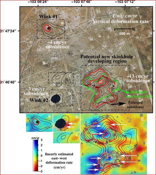
Measurements from satellite radar images of two giant West Texas sinkholes (dark black areas) shows the ground around them is sinking, including indications a potential new sinkhole is developing. The rates of east-west deformation of the ground (cm/year) are indicated in blue (eastward) and red (westward). (Jin-woo Kim, SMU)

A new study by geophysicists at Southern Methodist University, Dallas, finds the massive sinkholes are unstable, with the ground around them subsiding, suggesting the holes could pose a bigger hazard sometime in the future.
wink-texas-sinkhole-1.jpg

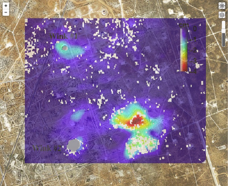
Potential new giant sinkhole forming in between the two already existing craters.

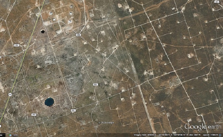
The two sinkholes — about a mile apart — appear to be expanding. Additionally, areas around the existing sinkholes are unstable, with large areas of subsidence detected via satellite radar remote sensing.
wink-texas-sinkhole-2.jpg

Location of the two giant holes in the ground bwteen Wink and Kermit, Texas

That leaves the possibility that new sinkholes, or one giant sinkhole may form. This is similar to Arizona where giant cracks mysteriously appear deep in the ground.

The ground collapses are probably related to oil operations in the area.
wink-texas-sinkhole-3.jpg

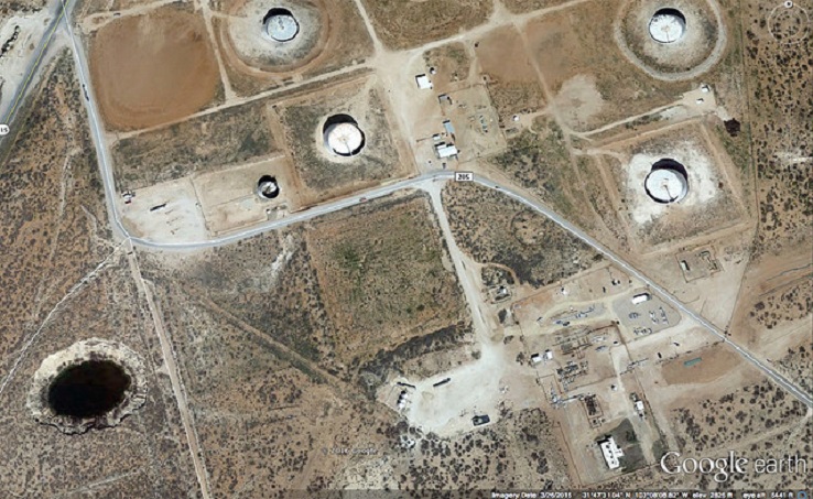
This area is heavily populated with oil and gas production equipment and installations, hazardous liquid pipelines, as well as two communities.
http://strangesounds.org/wp-content/uploads/2016/06/wink-sinkhole.jpg
Wink Sink 1, formed on June 3, 1980, measured 110-m across and 34-m deep at the time of collapse. On aerial photographs taken in 2004, it has an approximately circular outline that is 94- to 117-m across and is elongated to the northeast-southwest. University of Texas

The intrusion of freshwater to underground can dissolve the interbedded salt layers and accelerate the sinkhole collapse.

Wink Sink 2 formed 1.6 km south of Wink Sink 1 on May 21, 2002. This sinkhole has expanded from its original surface width of 137 m to an oval shape with widths ranging from 185 to 250 m. The cause of collapse at Wink Sink 2 has not been determined. University of Texas

And another longer article:

http://phys.org/news/2016-06-geohazard-giant-sinkholes-west-texas.html#jCp said:
Geohazard: Giant sinkholes near West Texas oil patch towns are growing—as new ones lurk
June 14, 2016


geohazardgia.jpg


Geohazard: Giant sinkholes near West Texas oil patch towns are growing — as new ones lurk
Measurements from satellite radar images of two giant West Texas sinkholes (dark black areas) shows the ground around them is sinking, including indications a potential new sinkhole is developing. The rates of east-west deformation of the ground (cm/year) are indicated in blue (eastward) and red (westward). Credit: Jin-woo Kim, SMU

Satellite radar images reveal ground movement of infamous sinkholes near Wink, Texas; suggest the two existing holes are expanding, and new ones are forming as nearby subsidence occurs at an alarming rate.

Residents of Wink and neighboring Kermit have grown accustomed to the two giant sinkholes that sit between their small West Texas towns.

But now radar images taken of the sinkholes by an orbiting space satellite reveal big changes may be on the horizon.

A new study by geophysicists at Southern Methodist University, Dallas, finds the massive sinkholes are unstable, with the ground around them subsiding, suggesting the holes could pose a bigger hazard sometime in the future.

The two sinkholes—about a mile apart—appear to be expanding. Additionally, areas around the existing sinkholes are unstable, with large areas of subsidence detected via satellite radar remote sensing.

That leaves the possibility that new sinkholes, or one giant sinkhole, may form, said geophysicists and study co-authors Zhong Lu, professor, Shuler-Foscue Chair, and Jin-Woo Kim research scientist, in the Roy M. Huffington Department of Earth Sciences at SMU.

"This area is heavily populated with oil and gas production equipment and installations, hazardous liquid pipelines, as well as two communities. The intrusion of freshwater to underground can dissolve the interbedded salt layers and accelerate the sinkhole collapse," said Kim, who leads the SMU geophysical team reporting the findings. "A collapse could be catastrophic. Following our study, we are collecting more high-resolution satellite data over the sinkholes and neighboring regions to monitor further development and collapse."

Lu and Kim reported the findings in the scientific journal Remote Sensing, in the article "Ongoing deformation of sinkholes in Wink, Texas, observed by time-series Sentinel-1A SAR Interferometry."

The research was supported by the U.S. Geological Survey Land Remote Sensing Program, the NASA Earth Surface & Interior Program, and the Shuler-Foscue Endowment at Southern Methodist University.

Unstable ground linked to rising, falling groundwater

The sinkholes were originally caused by the area's prolific oil and gas extraction, which peaked from 1926 to 1964. Wink Sink No. 1, near the Hendricks oil well 10-A, opened in 1980. Wink Sink No. 2, near Gulf WS-8 supply well, opened 22 years later in 2002.

It appears the area's unstable ground now is linked to changing groundwater levels and dissolving minerals, say the scientists. A deep-seated salt bed underlies the area, part of the massive oil-rich Permian Basin of West Texas and southeastern New Mexico.

Geohazard: Giant sinkholes near West Texas oil patch towns are growing — as new ones lurk

A schematic cross section in Winkler County shows zones where salt dissolved in the Salado Formation, and where subsidence of the ground was detected by satellite radar images. Oil was extracted from the Yates and Tansill formations, so that water flowing into the Salado Formation for oil production could cause the dissolution cavity and create the Wink sinkholes. Credit: Jin-woo Kim, SMU


1-geohazardgia.jpg

With the new data, the SMU geophysicists found a high correlation between groundwater level in the underlying Ogallala Aquifer and further sinking of the surface area during the summer months, influenced by successive roof failures in underlying cavities.

Satellite images and groundwater records indicate that when groundwater levels rise, the ground lifts. But the presence of that same groundwater then speeds the dissolving of the underground salt, which then causes the ground surface to subside.

Everything's bigger in Texas, and the Wink sinkholes are no exception

Officials have fenced off the two sinkholes near Wink, a town of about 940 people, and Kermit, a town of about 6,000 people. The giant holes are notable features on the area's vast plains, which are dotted mostly with oil pump jacks, storage facilities, occasional brush and mesquite trees.

Based on modeling of satellite image datasets, SMU's researchers report that Wink Sink No. 1, which is closer to the town of Kermit, appears to be the most unstable. The smaller hole of the two, it has grown to 361 feet (110 meters) across—the length of a football field.

"Even though Wink No. 1 collapsed in 1980, its neighboring areas are still subsiding," say the authors, "and the sinkhole continues to expand." An oval-shaped deformation circling the sinkhole measures three-tenths of a mile (500 meters) wide and is subsiding up to 1.6 inches (4 centimeters) a year.

Wink Sink No. 2, which is nine-tenths of a mile south of No. 1 and which sits closer to the town of Wink, is the larger of the sinkholes. It varies from 670 feet to 900 feet across.

Wink No. 2 is not experiencing as much subsidence as Wink No. 1. However, its eastern side is collapsing and eroding westward at a rate of up to 1.2 inches (3 centimeters) a year.

"Wink No. 2 exhibits depression associated with the ongoing expansion of the underground cavity," the authors report.

Some ground that doesn't even border the edges of the two sinkholes is also subsiding, the scientists observed. An area more than half a mile (1 kilometer) northeast of No. 2 sank at a rate of 1.6 inches (4 centimeters) in just four months.

Ground northeast of sinkholes is subsiding, suggesting new ones forming
2-geohazardgia.jpg

The largest rate of ground subsidence is not at either sinkhole, but at an area about seven-tenths of a mile (1.2 kilometers) northeast of No. 2. Ground there is subsiding at a rate of more than 5 inches (13 centimeters) a year.
Geohazard: Giant sinkholes near West Texas oil patch towns are growing — as new ones lurk
The largest rate of ground subsidence is not at either sinkhole, but at an area about seven-tenths of a mile (1.2 kilometers) northeast of No. 2. Ground there is subsiding at a rate of more than 5 inches (13 centimeters) a year. Credit: Google Earth; Yin-Woo Kim, SMU

It's aerial extent, the researchers report, has also enlarged over the past eight years when a previous survey was done.

"The enlarged deformation could be an alarming precursor to the potential future development of hazards in the vicinity," said the authors.

Additionally, ground along a road traveled by oil field vehicles, about a quarter mile (400 meters) directly north of No. 2, is subsiding about 1.2 inches (3 centimeters) a year.

Ground's movement detected with radar technique

The satellite radar datasets were collected over five months between April 2015 and August 2015. With them, the geophysicists observed both two-dimension east-west deformation of the sinkholes, as well as vertical deformation.

The SMU scientists used a technique called interferometric synthetic aperture radar, or InSAR for short, to detect changes that aren't visible to the naked eye.

"From 435 miles above the Earth's surface, this InSAR technique allows us to measure inch-level subsidence on the ground. This is a monumental human achievement, and scientists will not stop endeavoring to improve this technique for more precise measurements," said Lu, who is world-renowned for leading scientists in InSAR applications. Lu is a member of the Science Definition Team for the dedicated U.S. and Indian NASA-ISRO InSAR mission, set for launch in 2020 to study hazards and global environmental change.

InSAR accesses a series of images captured by a read-out radar instrument mounted on the orbiting satellite Sentinel-1A. Sentinel-1A was launched in April 2014 as part of the European Union's Copernicus program.

Simply put, Sentinel-1A bounces a radar signal off the earth, then records the signal as it bounces back, delivering measurements. The measurements allow geophysicists to determine the distance from the satellite to the ground, revealing how features on the Earth's surface change over time.

"Sinkhole formation has previously been unpredictable, but satellite remote sensing provides a great means to detect the expansion of the current sinkholes and possible development of new sinkholes," said Kim. "Monitoring the sinkholes and modeling the rate of change can help predict potential sinkhole development."

Sentinel-1A data were obtained from Sentinels Scientific Data Hub – Copernicus. Groundwater well data came from the Texas Water Development Board.
 
A scene out of the Twilight zone ....

A Florida man crashed his car into a fire hydrant on Wednesday, which caused a sinkhole to form underneath his feet. The 89-year-old man, who was celebrating his birthday, fell into the hole and drowned by the time they were able to pull him out.

Florida Man Drowns in Sinkhole Caused by His Car Hitting Fire Hydrant
https://sputniknews.com/us/201705131053569283-florida-man-fire-hydrant-sinkhole/

Robert Dreyer, a resident of Melbourne, Florida was driving in the nearby town of Viera in his 2016 G300 Mercedes Benz when he hit the hydrant. He exited the car, seemingly unharmed, but then the ground gave way underneath his feet. A five-foot-deep sinkhole was created, likely by the force of the crash.

"The force of the water created an air pocket and sucked him down into the hole where he was underwater for some period of time," said Lt. Channing Taylor of the Florida Highway Patrol.

​"The water started erupting from the fire hydrant. As a result, there was a divot in the space where the fire hydrant used to be and right adjacent to his driver's door, he fell into that divot." Witnesses claimed that jets of water shot several feet in the air, as well.

Witnesses of the crash rushed over to help Dreyer, but the water pressure was too great. "It was pushing me out of the hole, and I weigh 220 pounds," said local man Edward Cunningham.

​"And with so much water pressure we could have tried to link up and to get him out and we would have been getting sucked in too. We would have had to get that water shut off before we could do anything," added fellow witness Pedro Rodriguez.

Eventually, they managed to pull Dreyer out, but too late: he had been underwater for at least three minutes and had drowned. He was officially pronounced dead at Viera Hospital.

Florida authorities are investigating the crash. Fire hydrants usually don't create sinkholes when struck by a car, after all. "I haven't seen anything like this before," a police spokesperson told local station WESH. "Usually the fire hydrants will break off and they won't spew water; they have safety valves in place. But if you hit something the right way, the safety doesn't work."

The hospital believes that Dreyer may have suffered a medical incident shortly before the crash.
 
A giant sinkhole has swallowed a car in the U.S. The owner came back from the gym to find his car 6m underground. Published June 30th, 2017.

Massive sinkhole swallows car in US (Video)
https://au.news.yahoo.com/video/watch/36219542/massive-sinkhole-swallows-car-in-us/#page1
 
A large sinkhole opened in Florida Friday morning and has already swallowed two homes as it continues to grow.

Florida Sinkhole Swallows 2 Houses and It's Still Growing (Video)
http://time.com/4858619/florida-sinkhole-land-o-lakes-2/

Friday July 14, 2017 - According to ABC Action News in Tampa Bay, the sinkhole in Land O'Lakes began as the size of a small pool, and just before 8 a.m. E.T. Friday, a boat on the property fell in. Two homes then crumbled into the hole as it grew; Pasco County Fire Rescue told ABC that one home is entirely lost and the other is 60% gone.

According to CBS, no one was home at the time the houses fell into the sinkhole, but rescue crews saved two dogs. Surrounding houses have been evacuated, and power has been cut off to the neighborhood.


The Pasco County Sheriff's Office says the sinkhole, first reported as a depression, started out as the size of a small pool and a boat on the property was falling into the hole at approximately 7:36 a.m.

Sinkhole swallows 2 homes, continues to grow in Florida neighborhood as houses are evacuated (Videos)
http://www.wxyz.com/news/national/depression-forms-at-florida-home-surrounding-homes-evacuated?autoplay=true

Officials have confirmed the sinkhole is approximately 200 feet wide and approximately 50 feet deep. There is a 200 foot perimeter around the hole. The perimeter may be expanded if the sinkhole continues to progress.

Officials say there is concern that the sinkhole could merge into a nearby lake. Officials are monitoring the progression of the sinkhole and keeping residents out of the area.

As of 8:23 a.m., the sinkhole expanded and reached the roadway. At least 11 surrounding homes were evacuated.

Pasco County Fire Rescue provided a video of the first home collapsing into the sinkhole. Watch the video below:

Shortly after Tampa-based WFTS arrived on scene, the second home collapsed into the sinkhole. Watch the video below:

Duke Energy has cut power in the area as a safety precaution, leaving 100 homes without power. No injuries have been reported.

Pasco County officials are tagging nearby homes where they have not been able to make contact with occupants.
 
angelburst29 said:
Sinkhole swallows 2 homes, continues to grow in Florida neighborhood as houses are evacuated (Videos)
http://www.wxyz.com/news/national/depression-forms-at-florida-home-surrounding-homes-evacuated?autoplay=true

Update:

The Florida sinkhole that swallowed two homes last week isn’t getting any deeper, but it’s getting wider, officials said Wednesday — and one resident who’s back home after being evacuated is vowing to stay unless the hole consumes her house.

As Florida sinkhole widens, some are determined to stay put
http://abcnews.go.com/US/wireStory/florida-sinkhole-widens-homes-evacuated-48725220

“I’m apprehensive, a little nervous,” said Patty Camunas, 57, whose family lives near the sinkhole.

But she added, “Where are you going to go? There are sinkholes all over Florida. Unless something happens that the sinkhole takes my house, I don’t plan on going anywhere anytime soon.”

Camunas was at work Friday morning when the sinkhole swallowed one house about 200 feet behind hers. Her husband and daughter were home when officials told them to evacuate. They were allowed to return Saturday but decided to give it an additional 24 hours. On Sunday, they returned.

“The only thing we lost is the food from the power being shut off,” she said.

Now, she said, the main commotion on her cul-de-sac is from curious people driving to the neighborhood to take selfies with the sinkhole in the background.

During a news conference Wednesday, officials in Pasco County — a suburban area north of Tampa — said that because of the sinkhole’s growth, residents of two additional homes in the neighborhood have been warned they may need to evacuate. They were told to gather their possessions in preparation of leaving, said Kevin Guthrie, Pasco County’s assistant administrator for public safety.

Five homes near the sinkhole already had been evacuated.

“This is not a time for panic. We have somebody out here monitoring this sinkhole, monitoring the expansion. We will let people know in plenty of time that they need to get their stuff together and be ready to go,” Guthrie said. “When we say, ‘Now is the time to leave.’ It’s time to leave. It’s not time to pack things up.”

The edges of the sinkhole are caving in because there’s no support for the sandy soil as it dries out, officials said.

It’s now about 235 feet (72 meters) wide, about 10 feet (3 meters) wider than it was several days ago. It remains 50 feet (15 meters) deep.

As the water in the sinkhole recedes, the sand on the right-angled banks can’t support the weight of the ground and it’s giving away. Engineers believe the solution lies in quickly getting dirt into the area to create a sloping bank that can keep the edges of the sinkhole from falling in, Guthrie said.

“We’re working to that end right now,” Guthrie said.

Engineers hope to start bringing in dirt and removing debris over the weekend, or early next week.

None of 20 water wells tested came back positive for E. coli, but water samples from 17 of the wells will be re-tested for any signs of contamination. Greg Crumpton, a local health official, said elements found in water from those wells may be the result of improper maintenance by homeowners, but health officials want to make sure it’s not from the sinkhole.

Pasco County’s risk manager has told officials that the response to the sinkhole could cost at least $1.5 million but it will be likely much more, Guthrie said.
 
A GIANT sinkhole has opened up in the middle of a busy street in the Italian city of Rome, which plunged a terrified elderly woman two metres below the road.

Giant sinkhole in Rome opens up and SWALLOWS elderly woman two metres below Tue, Jan 16, 2018 (Video)
https://www.express.co.uk/news/world/905488/Rome-sinkhole-italy-earthquake-latest-news-Piazza-Bologna-woman-injured

A 77-year-old woman was walking on the pavement when she suddenly fell into the two-metre deep crater, which appeared on Tuesday morning.

Emergency services scrambled to the street in Catania, in the Piazza Bologna, to rescue the injured woman.

The woman was rushed to Policlinico Umberto I hospital, where she was treated for minor injuries.

The road was closed off while officials investigated the causes of the crater.

It comes after a huge crater, five metres deep and three metres in diameter, appeared in the Montagnola district of Rome last year.

Enzo Foschi was one of the first politicians to post a picture on social media, saying: “Luckily at that moment no one was crossing the street and no one got hurt. “Rome collapses and mayor Raggi says everything is all right."

Carved up by two major fault lines, Italy has gained a reputation as one of the most earthquake prone countries in Europe.

The Eurasian and African plates meet along a line which runs through North Africa and crosses the Mediterranean near southern Italy and Greece.

As a result two main cracks - or fault lines - cut across the Italian peninsula, one running north-south along the spine of the Apennine mountains and another crossing east-west south of Rome and north of Naples.
 
WATCH Cars Swallowed Up by Huge Sinkhole in Rome 15.02.2018
https://sputniknews.com/europe/201802151061689351-rome-sinkhole-cars-evacuation/

Two buildings near the crater were evacuated as a precaution over fears that structural damage to the buildings could cause them to collapse. The causes of the incident are still being investigated.

On Wednesday, at 6 pm local time, the road in the center of the Italian capital collapsed and formed a massive sinkhole 9-meters deep, which consumed at least eight cars, media reported. The site was immediately cordoned off and firefighters were dispatched to the scene. Fortunately, no injuries were reported after the incident.
 
May 22, 2018 - An actual sinkhole has opened on the White House lawn. It’s growing (Photos)
An actual sinkhole has opened on the White House lawn. It’s growing

Construction on the US White House began in 1792. It has been almost continuously occupied by US presidents since 1800, barring a few years after the British set it on fire in 1814.

But that doesn’t mean that the present-day building is free of hazards—there are mice, cockroaches, and ants. And as of this past weekend, a sinkhole has been growing on the north lawn, Voice of America reporter Steve Herman observed, just near the press briefing room.

“It was noticeably bigger between Sunday and Monday,” Herman said. “It’s more than a foot long right now,” he said. A second sinkhole has opened up right next to it, he said.

Update: According to Herman, the sinkhole appears to have been covered up by White House staff.

Often described as a “swamp” of corruption, parts of the city of Washington, DC, are also literally built on a swamp. The city’s geological issues also include “forebulge collapse,” a post-Ice Age condition that means the city could sink as much as six inches this century.

Sinkholes have opened up across the city in recent years. They forced two residents to abandon their homes in March, and swallowed up a school bus last year. This is the first report of one on the White House lawn.

Last year, a giant hole opened in the earth in front of Donald Trump’s Florida resort, but that was due to a new water main, not a geological condition.
 
Mesmerizing footage shows a large chunk of land collapsing into a huge swirling sinkhole in Kericho, in the highlands west of the Great Rift Valley in Kenya, east Africa.

Bizarre video shows giant swirling sinkhole consuming huge chunks of grass
The fascinating natural occurrence erupted on Friday in a Kericho county village along the East Africa's Great Rift Valley. (SWNS)

"The fascinating natural occurrence erupted on Friday in a Kericho county village along the East Africa's Great Rift Valley.

‎May‎ ‎04‎, ‎2020‎ - The video shows the seemingly small sinkhole start sucking in water from a large puddle, before pulling in huge chunks of mud and long grass.

Locals can be overheard shouting and laughing in shock and amazement at the scene, which took place on Friday.

Heavy rain has battered the region, leading to severe flooding and landslides across Kenya that left 100 people dead and nearly 2,000 homeless.

"The rift valley being a tectonic active zone, there are various cracks, holes and underground voids.

"Following heavy rains in the regions, the overlying soil was eroded exposing the cracks and voids underground.

"This caused the runoff water to sip in through the openings to fill up the spaces."

Kenya’s Great Rift Valley is part of the East African Great Rift Valley, a series of trenches spanning approximately 6,000km that is in the process of splitting the African Plate into two separate plates.

Flooding along Kenya’s Nzoia River, which burst its banks on Thursday, has left many thousands of homes submerged.

Images show residents wading through the waters after their home was flooded and setting up makeshift shelters on the raised ground near floodwaters.
 
Back
Top Bottom