You are using an out of date browser. It may not display this or other websites correctly.
You should upgrade or use an alternative browser.
You should upgrade or use an alternative browser.
The Ice Age Cometh! Forget Global Warming!
- Thread starter Gaby
- Start date
SubnetUnMask
Jedi Master
That is cold for the middle of July.SW France, on July 9, it was 14 C in the morning.
South-east South Carolina here, and I have lived in this area since the late 1980's - this is by far the coolest Summer I can ever recall. Every morning and evening is around 75F/23C, and during the day mid 80's, barely a few days in the 90's so far.
Just moved back into Europe last night, only to be greeted by cooler temps and a light snow dusting on the upper mountain range.
Another big set back to the fear mongers of global warming call the current cold wave an anomaly. LOL!
Pic du Midi
#neige at the Port of Venasque 2444m / Benasque #luchon#pyrenees Julien Laporte Mountain Guide
People are noticing the discrepancy's.
Please specify that this first fortnight of July currently presents a severe thermal deficit on the maximums, sometimes around -3 ° on the 13th !! On the minimum it is more resonable but in the meantime it is very fresh and we are far below the standard
In Western North Carolina, we had temps at night in the mid to low 50's F (approx 11.7 deg C or so) after the solstice and into end of June. This summer is much cooler then the past 3 or 4 summers.South-east South Carolina here, and I have lived in this area since the late 1980's - this is by far the coolest Summer I can ever recall. Every morning and evening is around 75F/23C, and during the day mid 80's, barely a few days in the 90's so far.
Lyndi
Jedi Master
Consistently for couple years, eastern Ontario, Canada, higher than historic average night temperatures, lower day temperatures. This week the 14 day forecast shows, typically, night is about 2 deg C higher than 'historic' and 2 deg C lower during the day. 'Historic average on this weather site refers to last year only. So for two years the trend has deepened.
We had high heat and humidity of late, following a bit of a drought. Last year, similar pattern, market gardener here said worst year for growing since she started a decade or so ago. First drought, then torrential rains, late spring, early fall.
Also a plague of Gypsy Moths stripping trees. Last year 570,000 hectares of Ontario forests denuded and we didn't see that locally, different story this year. Glad to say, stripped trees have new leaves, awful to see them standing bare and now wonderful to see the second spring of being full in bright green leaf. We learned how to protect the trees but it took a lot of time and effort, which a few triaged trees did get. Since the rains this last week or so brought virus and fungi that kill the caterpillars, their march through forests should be slowed or stopped. It's what arborists say they depend on for the munching of leaves to stop, that the caterpillars get very sick and die.
Oh my, another game changer in the wings.
The long-term forecasts of the #VórticePolar indicate that it can give surprises this winter, and perhaps earlier than normal. There is a long way to go to ensure, but it is something to watch out for ...

 www.sott.net
Edit Added:
Good morning! We wake up with clear skies and temperatures cold. It was not so cold in the morning from Sant Joan.
The long-term forecasts of the #VórticePolar indicate that it can give surprises this winter, and perhaps earlier than normal. There is a long way to go to ensure, but it is something to watch out for ...
Recap: The changing jet stream and global cooling
Studying the JET STREAM has long been an indicator of the weather to come, and to study the jet stream attention must turn to the SUN. When solar activity is HIGH, the jet stream is tight and stable and follows somewhat of a straight path. But...
www.sott.net
Edit Added:
Good morning! We wake up with clear skies and temperatures cold. It was not so cold in the morning from Sant Joan.
Last edited:
Oh my, another game changer in the wings.
At least in BC, this does not surprise me following the type of heat season currently being experienced. One may follow the other, and earlier as was suggested.The long-term forecasts of the #VórticePolar indicate that it can give surprises this winter, and perhaps earlier than normal. There is a long way to go to ensure, but it is something to watch out for ...
Some excerpts from latest Electroverse article:
Full article here.
Remember what the Cs said way back in the 18 March 2000 session:
“SNOWSTORM IN AFRICA!” — SOUTH AFRICA SMASHES *AN ADDITIONAL* 19 ALL-TIME LOW TEMPERATURE RECORDS OVER THE PAST 24 HOURS
Following on from the record-smashing cold that infected Southern Africa on Thursday, the SA Weather Service (SAWS) has confirmed that a further 19 low temperature records were broken in the past 24 hours alone.
The service had warned that the country to brace for the coldest night of the year; however, it turned out to be the coldest night in recorded history for many locales, with records set 20, 40 and even 60+ years ago falling by the wayside.
“Snowstorm in Africa!” reads the below tweet from @sapeople, during the “#ColdestDayEver!”.
The video was shot on Uniondale road. The driver of the vehicle is heard calling the conditions “absolutely bizarre”. And he continues, saying: “I have never had to drive through a snowstorm in Africa before.”
These are truly unprecedented conditions for this part of the world.
And anthropogenic global warming (i.e. carbon dioxide emissions) has zip-all to do with it; no, the mechanism behind these polar outbreaks (and indeed the recent punishing heatwave in the Pacific Northwest) is the historically low solar activity we’re receiving–namely its impact on the jet streams.
Full article here.
Remember what the Cs said way back in the 18 March 2000 session:
Q: You also made a remark once that ice ages occur much, much faster than people ever thought...
A: Yes.
Q: Do we need to invest in some mukluks and snowshoes?
A: ??
Q: Well, what I am trying to get at is: should we start stockpiling firewood?
A: Maybe.
Q: So, it could be that fast?
A: Oh yes, and faster when in response to global"warming."
Q: When you put "warming" in quotes, you obviously mean warming in more than just an ordinary sense? Is that correct?
A: And/or not really "warm."
''new'' research on the flash frozen mammoths Younger Dryas Myth-Busting: Flash-Frozen Mammoths Edition
basically says no younger dryas frozen mammoth ...all much older also no mammoth would eat buttercups , even if they grew where they lived as it is toxic to grazing animals , the plant material found is ''normal'' mammoth food like bark lichen etc.
basically says no younger dryas frozen mammoth ...all much older also no mammoth would eat buttercups , even if they grew where they lived as it is toxic to grazing animals , the plant material found is ''normal'' mammoth food like bark lichen etc.
Teaser Snip:
RIO DE JANEIRO, BRAZIL – The forecast of severe cold and snowfall in the mountains of Santa Catarina on Wednesday (28) caused the demand for accommodation to skyrocket.
The weather phenomenon in the country’s south should thermometer remain between 0 and 5° C across the state in the early hours of Wednesday and during Thursday. It may reach -8° C in the region’s peaks, according to reported Epagri / Ciram, weather agency of Santa Catarina.
Update:
It always gets me that MSN ignores the reality with the false narrative of the globular heat scam, as temps continue to go erratic.
Over the weekend the joint probability model continues to show a sharp drop in mercury & rainfall that may be outside the Pyrenees, for now maybe more than half north but note that it will turn quite still but aims well #meteo#324eltemps
Crazy weather everywhere, and yet most people are distracted by variant delta (or whichever the latest alphabet letter they will shortly come up with). This distraction, whether deliberate or being a natural part of the control for other purposes, will end up with people being caught up in weather events unaware with dramatic consequences. It's like a different planet all of a sudden.
TIME | Temperature at 21h of 1°C in São José dos Absentes and 10°C in Canoas air base. Here comes another very cold dawn and again with negative marks in the higher altitude areas.
-1 this August 1st at 2800m and a little #neige to @PicduMidi#pyrenees

 picdumidi.com
Actually that's IN FRANCE! They got me wrong! Sorry!
 noticias.r7.com
28/07/2021 - 12h43 (Atualizado em 29/07/2021 - 12h33)
noticias.r7.com
28/07/2021 - 12h43 (Atualizado em 29/07/2021 - 12h33)
-1 this August 1st at 2800m and a little #neige to @PicduMidi#pyrenees
Weather conditions at the Pic du Midi | Pic du midi
Instant detailled conditions for the visit
picdumidi.com
Actually that's IN FRANCE! They got me wrong! Sorry!
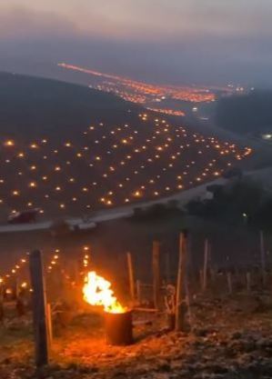
É falso vídeo que mostra fogueiras em parreiral de Bento Gonçalves
Técnica é usada na França para evitar a perda do fruto nas baixas temperaturas e assim garantir a colheita também no inverno
noticias.r7.com
Last edited:
Trending content
-

-
Thread 'Coronavirus Pandemic: Apocalypse Now! Or exaggerated scare story?'
- wanderingthomas
Replies: 30K -
-
