VIDEOS. A tornado Sunday in the region of Toulouse

Ca.

The Living Force
FOTCM Member
:shock: Is this normal?
A tornado Sunday in the region of Toulouse
| Published on 30.04.2012, 10:24 | Updated: 11:06
http://www.leparisien.fr/toulouse-31000/videos-une-tornade-dimanche-dans-la-region-de-toulouse-30-04-2012-1978788.php
A dense cloud, dark and threatening, belly which a vortex of air "dirty yellow" tumbles funnel until the dust: it is a tornado, relatively small, as we saw Sunday night to undulate southwest of Toulouse, between Muret and Seysses. An unusual weather phenomenon that has lasted a few minutes.

According to the Depeche du Midi, it has only some damage in a farm Seysses, at a place called Galiane where silos have been gutted and a fragile roof. Meteorologic.net explained that a storm area was formed Sunday night north of the region. South of this area, the wind convergence was such that a rotating thunderstorm called "supercell" was formed, generating itself, around 19:30, the famous "snorkel" that many witnesses have seen. The tornado could be classified into F1 on the Fujita scale. phenomenon, recurring during the summer in the U.S., where over a hundred people die each year, much less so in France . Last December, several waterspouts were observed off the coast of Nice. AMATEURS VIDEOS

Tornade sud Toulouse 29 avril 2012
http://www.youtube.com/watch?v=LsakkdkOrwY&feature=player_embedded

Tornade Toulouse 29 Avril 2012
http://www.youtube.com/watch?v=hndZeQvZtL0&feature=player_embedded

Tornade Toulouse !!!
http://www.youtube.com/watch?v=2BCGsQutmbA&feature=player_embedded

Tornade au Lherm !! 29.04.2012
http://www.youtube.com/watch?v=yM_Spvskoio&feature=player_embedded
 

Attachments

  • Toulose Tornade 4-30-12.jpg
    Toulose Tornade 4-30-12.jpg
    13.5 KB · Views: 2
I don't think it's usual. But, in times of climate change, it's probably normal!
 
  • Like
Reactions: Ca.
It's certainly far from being what's considered typical for a Southern France weather! I guess we'll be seeing a lot of these in countries where they are normally rare. Electrical discharges, drastic changes in temperature, and there you go.
 
  • Like
Reactions: Ca.
I took these on the 25th, i have not seen this level of intensity in this area. i also have digitally enhanced them for some better detail and they were under exposed when taken. But they were still plenty dark at the time. i had to pull over while driving as it was eye opening and little jaw dropping as they looked like tornado clouds.

These were some of the most ominous looking cloud pattens, and they even looked mean, with dark energy.

Almost as if,they were being effected by 4th density bleed through.
 

Attachments

  • High E C 4-25-12 (700x393).jpg
    High E C 4-25-12 (700x393).jpg
    219.3 KB · Views: 14
  • High energy clouds.jpg
    High energy clouds.jpg
    207.1 KB · Views: 12
Great photos! And yes, we've been having those kinds of clouds around here, too.
 
  • Like
Reactions: Ca.
Laura said:
Great photos! And yes, we've been having those kinds of clouds around here, too.

Thanks, :). These were taken yesterday. It has been none stop, off, and on rain here, as this area starts its fourth week of the same rain whether patterns, with stronger than normal wind gust lately. Locals just shrug.

There was also some rain that had dust in it leaving a light coating of mud on the vehicle on Saturday.

This was more than likely blown in from Spain, before the mountains, north, picked up from the high desert area and blown into the upper atmosphere.

Scary Plane Landing in Bilbao, Spain; High winds rock plane as it lands "
_http://www.youtube.com/watch?v=MltpX7TDjl8
 

Attachments

  • NXNE-4-29-12 (680x505).jpg
    NXNE-4-29-12 (680x505).jpg
    278.8 KB · Views: 3
  • STB_0341 (680x420).jpg
    STB_0341 (680x420).jpg
    247.2 KB · Views: 6
c.a. said:
These were some of the most ominous look cloud pattens, and they even looked mean, with dark energy.

Almost as if,they were being effected by 4th density bleed through.

Impressive and interesting, sure. "Dark energy", "mean", etc. that might just be our subjective perception of events we aren't even close to understanding.

On the other hand, if we ever get one of these....

angry_cloud_by_Funinana.jpg


that's another story. ;)
 
  • Like
Reactions: Ca.
Hmm
Ailén said:
c.a. said:
These were some of the most ominous look cloud pattens, and they even looked mean, with dark energy.

Almost as if,they were being effected by 4th density bleed through.

Impressive and interesting, sure. "Dark energy", "mean", etc. that might just be our subjective perception of events we aren't even close to understanding.

On the other hand, if we ever get one of these....

angry_cloud_by_Funinana.jpg


that's another story. ;)

To coin a phrase, "The sky was angry that day." :whistle:
 
While not quite in Toulouse, we also had a "significant" rainfall for April here in Perth, Western Australia on the 29th;

Sunday April 29, 2012

Rain fell at a steady rate in the Perth region on Saturday afternoon, bringing the first significant rainfall since December.

The rain started at 5.30pm yesterday evening, accumulating a total of 41mm, 38 of which fell in just five hours before midnight.

Slightly heavier rain fell in the nearby coastal regions, 62mm at Floreat Park and 56mm at Swanbourne. This is Swanbourne's heaviest April rainfall in 10 years.

The rain was caused by a low pressure trough laden with tropical moisture of Indian Ocean origin, which was then drawn across the state by strong upper level westerly winds. This supply of moisture was enhancing the development of a low pressure system along a cold front to the south. On Sunday afternoon this system continues to bring showers and fresh westerly winds gusting up to 40km/h.

It's a few degrees colder in the wake of this system with Perth's maximum struggling to reach 23 degrees on Sunday. By Monday the sky should start to clear again, with only a possible morning shower in the forecast. The cool airmass is expected to linger with below average maxima on Monday and Tuesday.

- Weatherzone

Nothing major quite like a tornado in Toulouse, but the timing is interesting. It's been uncharactisically dry this month, until this.
 
  • Like
Reactions: Ca.
thanks for the video... and really nice pictures as well..!

i got tons of there..i will probably at some point make an album of them online and post it here, there's a couple of hundred.. :P

funny thing is in the area where I'm at, they seem to have become a lot less common, i remember a couple of years ago almost every day in summer would have an amazing cloud shooting session, where lately it has been rather lame.. :P
 
  • Like
Reactions: Ca.

There's something significant that happened (on the 3 dates in Red), in September, that had ramifications across the globe.

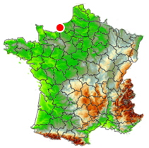
Tornado EF1 in Le Havre (Seine-Maritime) on September 25, 2020
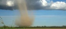
On September 25, 2020, at 4:36 am local time, a low-intensity tornado (EF1), originating from a waterspout, crossed several districts of Le Havre (Seine-Maritime). The phenomenon, which blows up beach huts and then damages three restaurants, is felt as far as the outskirts of the industrial port area.

The Le Havre tornado of September 25, 2020 is part of a tornado outbreak (grouped tornado episode) which totals 5 cases for the days of September 23, 24 and 25, 2020 (interruption of less than 24 hours between each case), including tornado EF2 from Port-des-Barques (Charente-Maritime), tornado EF0 from Marennes-Hiers-Brouage (Charente-Maritime), tornado EF0 from Croix-Valmer (Var) and tornado EF0 from Fayence (Var) .

It should be noted that the city of Le Havre has already been struck three times by a tornado in similar circumstances: August 21, 1904 (EF1), January 18, 1906 (EF2) and more recently December 1, 2007 (EF1) where the phenomenon particularly strikes Gonfreville-l'Orcher.

* Maximum intensity: EF1, i.e. winds estimated between 135 km / h and 175 km / h
* Distance traveled: 5.5 kilometers
* Average width: 100 meters

* Common crossing: LE HAVRE (promenade André Duroméa, Saint-Vincent-de-Paul, Saint-Michel, station, the Docks, boulevard Jules Durand)
* Department: SEINE-MARITIME (76)
* Average altitude of the terrain: 6 meters
* Type of land: continuous urban fabric; industrial and commercial areas; port areas; intertidal zones

* Main damage: limbed or severed trees and branches blown away; dozens of blown-up beach huts and strewn debris; four damaged beach restaurants (furniture taken, windows exploded, walls bent, roofs washed away); broken windows on vehicles; dozens of damaged homes (broken windows, collapsed chimneys, torn shutters, rows of tiles blown away, a roof partially torn off); metal shutter and bay window of a car dealership unsealed; street furniture twisted or bent by the wind; many debris of branches, sheets and tiles in the streets

tornade-le-havre-25-septembre-2020-seine-maritime-normandie-trombe-outbreak-localisation.png
NB: the intensity of tornadoes is determined on the increased EF scale (English version). This version of the EF scale, developed and implemented by KERAUNOS since 2009, adds to the American criteria a series of specific features specific to European housing and thus allows a precise rating of tornadoes, valid as much for contemporary tornadoes as for tornadoes of the past, and internationally consistent.

Blown beach huts and damage in the city

The Havre tornado of September 25, 2020 was identified with the support of press articles, a CCTV camera from a beach restaurant, and thanks to the invaluable contribution of Siegfried Marechal, Paul Giannoni and 'Etienne Delauney who were able to determine a corridor of damage 100 meters wide. The testimony of one of them is characteristic: "I heard it coming from afar and leaving a bit like a plane. The whole building shook."

The Havre tornado of September 25, 2020 was identified with the support of press articles, a CCTV camera from a beach restaurant, and thanks to the invaluable contribution of Siegfried Marechal, Paul Giannoni and 'Etienne Delauney who were able to determine a corridor of damage 100 meters wide. The testimony of one of them is characteristic: "I heard it coming from afar and leaving a bit like a plane. The whole building shook."

The phenomenon arose from a waterspout that entered land at 4:36 am local time, at which time a CCTV camera recorded the passage of the whirlpool on the restaurant "La P'tite Plage". We can very clearly distinguish the gyratory movement of the wind, with a first suction of chairs, then a violent contrary movement which coincides with the tornado itself:


Back
Top Bottom