You are using an out of date browser. It may not display this or other websites correctly.
You should upgrade or use an alternative browser.
You should upgrade or use an alternative browser.
Volcanoes Erupting All Over
- Thread starter Laura
- Start date
angelburst29
The Living Force
Bravo c.a., you were ahead of the bad news. The warnings were there.
I get tired of stories such as this but not being an expert in this area I have no idea if the issue is the government of Indonesia or the so called "Warning System"
Monday, 24 December, 2018 - Indonesia’s President: Tsunami Which Hit the Country Is of Vague Nature
Indonesia’s President: Tsunami Which Hit the Country Is of Vague Nature
Indonesia’s President Joko Widodo said that relevant agencies could not warn of the tsunami which killed more than 280 people beforehand. He said about it on Monday after visiting Pandeglang Regency in Banten Province on the island of Java, news portal Detik reported.

"Experts still cannot name the exact reason for the disaster, so it is necessary to refrain from making conclusions," Widodo said. "The tsunami is of a vague nature, and various agencies responsible for the warning could not detect its approach beforehand."
The president noted that "the task was set for the corresponding agencies to check the operating equipment and urgently replace the failed elements of the nationwide system of early tsunami warning."
"It will be done at the beginning of the next year," Widodo said.
Spokesman for the National Agency for Disaster Management (BNPB) Sutopo Nugroho earlier reported that 281 people were killed and more than 1,000 were injured in the disaster. To date, 57 people are missing, but this figure is expected to grow. A total of 229 deaths were earlier reported.
* Iran Offers Condolences over Indonesia's Devastating Tsunami
In a message on Monday, Iran's President Hassan Rouhani offered condolences to the Indonesian government and people over the recent tsunami that has left hundreds of people killed and maimed.
'The tragic news of Sunda Strait tsunami, which injured and claimed the lives of hundreds of people, is a deep sorrow to me,' President Rouhani said in his message released on Monday to his Indonesian counterpart Joko Widodo.
'On behalf of the Iranian government and people, I hereby offer my sincerest condolences to Your Excellency, the government and the people of Indonesia and wish the bereaved families patience,' another part of the message read.
Following the eruption at the volcano of Anak Krakatau, tsunami waves stuck at Sunda Strait on Saturday.
As the volcanic activity continues and the eruption worsens, the environmental experts have warned that another tsunami may break out in the region.
The volcano-triggered tsunami has wounded over 1,016 and more than 30 people have gone missing.
* Russia ready to help Indonesia create disaster early warning system

Meanwhile, Russia is ready to provide assistance in creating a natural disaster early warning system for Indonesia, where over 280 people have been killed in a devastating tsunami, chief of Russia’ state space corporation Roscosmos Dmitry Rogozin said on Monday.
"We are ready to provide assistance for Jakarta in creating a natural disaster warning system. We have invited Indonesia’s Ambassador to familiarize with the possibilities of Russia’s orbital system of the Earth’s remote sensing," Rogozin wrote on Twitter.
A tsunami struck areas of the Sundra Strait separating the islands of Java and Sumatra on the night of December 22. A spokesman for Indonesia’s National Agency for Disaster Management (BNPB), Sutopo Nugroho, said the death toll has reached 281 and over 1,000 people have been injured. At the moment, 57 people have gone missing. The disaster is believed to have been caused by the eruption of the Anak Krakatau volcano.
Indonesian President Joko Widodo admitted that the country’s agencies had been unable to alert citizens about the tsunami threat.
The president set the task to check the equipment and immediately replace non-effective elements of the nationwide tsunami early warning system.
Hi_Henry
The Living Force
Monday, 24 December, 2018 -
Indonesia’s President Joko Widodo said that relevant agencies could not warn of the tsunami which killed more than 280 people beforehand. He said about it on Monday after visiting Pandeglang Regency in Banten Province on the island of Java, news portal Detik reported.
The tsunami is believed to have been caused by undersea landslides that followed an eruption of the Anak Krakatau volcano. There were no significant seismic tremors to indicate a tsunami was coming. Anak Krakatau, which is roughly halfway between Java and Sumatra, has been spewing ash and lava for months.
My post previous to this one shows the piece of land that is gone (lower left side).
Pictures of Dangerous Beauty that Creates
Hi_Henry
The Living Force
If you wish to see what is going on the Earth check this out,
Quakes
Climate interests you ? Try this,
Global Streams
Quakes
Climate interests you ? Try this,
Global Streams
Hi_Henry
The Living Force
Have a look at the magnetopause on Dec. 22 and do the same for 23rd. 22nd is jumpy.
Magnetosphere
This tool displays the estimated location of the Earth's magnetopause, the abrupt boundary separating the solar wind from the Earth's magnetic field. The stand-off distance and shape of the magnetopause are controlled by the dynamic and static pressure of the solar wind, the pressure of the Earth's magnetic field, and the orientation of the Interplanetary Magnetic Field (IMF). The solar wind and IMF field data used for this model originate from the NOAA/NASA DSCOVR (Deep Space Climate Observatory) spacecraft orbiting the L1 point (a point between the Sun and Earth where gravitational forces balance).
The graphical presentation is in the equatorial plane as viewed from above the Earth's north pole. Geosynchronous orbit is shown at a distance of 6.6 Earth radii (Re) from the centre of the planet, with four longitude spokes. The locations of 12 geosynchronous satellites are indicated. The legend in the lower left identifies the satellites.
Magnetosphere
angelburst29
The Living Force
P.S. Sorry about the two blanks in my last Post. When I Post something, I always check it - incase it needs editing and the photos were there but now they have disappeared? Sorry about that.
December 24, 2018 - Italy's Mount Etna erupts, authorities close Airport
Italy's Mount Etna erupts, authorities close airport | Reuters
CATANIA, Italy - Italy’s Mount Etna, Europe’s highest and most active volcano, erupted on Monday, sending a huge column of ash into the sky and causing the closure of Catania airport on Sicily’s eastern coast.
A chain of around 130 earth tremors have rocked the volcano since around 0800 GMT on Monday, Italy’s National Institute for Geophysics and Volcanology said, with the strongest posting a magnitude of 4.0.
There were no reports of any injuries.
The 3,330 meter high volcano can burst into spectacular action several times a year, spewing lava and ash high over the Mediterranean island. The last major eruption was in 1992.
Published on Dec 24, 2018 (2:11 min.)
December 24, 2018 - Italy's Mount Etna erupts, authorities close Airport
Italy's Mount Etna erupts, authorities close airport | Reuters
CATANIA, Italy - Italy’s Mount Etna, Europe’s highest and most active volcano, erupted on Monday, sending a huge column of ash into the sky and causing the closure of Catania airport on Sicily’s eastern coast.
A chain of around 130 earth tremors have rocked the volcano since around 0800 GMT on Monday, Italy’s National Institute for Geophysics and Volcanology said, with the strongest posting a magnitude of 4.0.
There were no reports of any injuries.
The 3,330 meter high volcano can burst into spectacular action several times a year, spewing lava and ash high over the Mediterranean island. The last major eruption was in 1992.
Translated from Indonesian by Microsoft
The son of Krakatau Mountain conditions divideokan from KRI Teluk Cirebon 543 26/12/2018 pads, 16.33 BST. The eruption is still underway. The type of eruption of Mount Krakatau spewing strombolian Son ash and incandescent rock pebbles while letting continuously. Alert status (level 2).
The son of Krakatau Mountain conditions divideokan from KRI Teluk Cirebon 543 26/12/2018 pads, 16.33 BST. The eruption is still underway. The type of eruption of Mount Krakatau spewing strombolian Son ash and incandescent rock pebbles while letting continuously. Alert status (level 2).
angelburst29
The Living Force
December 26, 2018 - Indonesia orders flights to steer clear of erupting Anak Krakatau Volcano
Indonesia orders flights to steer clear of erupting Anak Krakatau volcano | Reuters
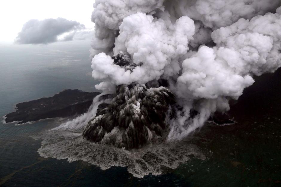 An aerial view of Anak Krakatau volcano during an eruption at Sunda strait in South Lampung, Indonesia, December 23, 2018 in this photo taken by Antara Foto. Antara Foto/Bisnis Indonesia/Nurul Hidayat/ via REUTERS/File Photo
LABUAN, Indonesia - Indonesia on Thursday raised the alert level for the erupting Anak Krakatau volcano to the second-highest, and ordered all flights to steer clear, days after it triggered a tsunami that killed at least 430 people.
A crater collapse on the volcanic island at high tide on Saturday sent waves up to 5 meters (16 feet) high smashing into the coast on the Sunda Strait, between the islands of Java and Sumatra.
Authorities have warned that the crater of Anak Krakatau, or child of Krakatau, remains fragile, raising fears of another collapse and tsunami, and have urged residents to stay away from the coast.
The volcano has been rumbling on and off since June but has been particularly active since Sunday, spewing lava and rocks, and sending huge clouds of ash up to 3,000 meters into heavily overcast skies.
The national geological agency, in raising the alert level to the second-highest, set a 5-km exclusion zone around the island.
Since December 23, activity has not stopped ... We anticipate a further escalation,” said Antonius Ratdomopurbo, secretary of the geological agency.
A thin layer of volcanic ash has been settling on buildings, vehicles and vegetation along the west coast of Java since late on Wednesday,
according to images shared by the national disaster mitigation agency.
Authorities said the ash was not dangerous, but advised residents to wear masks and goggles when outside, while aircraft were ordered away.
“All flights are rerouted due to Krakatau volcano ash on red alert,” Indonesia’s air traffic control agency AirNav said in a release.
AirNav’s corporate secretary, Didiet K.S. Radityo, told Reuters there were no disruptions to any international or domestic flights.
The civil aviation authority said no airports would be affected. The capital, Jakarta, is about 155 km east of the volcano.
Indonesia is a vast archipelago that sits on the Pacific “Ring of Fire”.
Slideshow (6 Images)
Indonesia orders flights to steer clear of erupting Anak Krakatau volcano | Reuters
Indonesia orders flights to steer clear of erupting Anak Krakatau volcano | Reuters
LABUAN, Indonesia - Indonesia on Thursday raised the alert level for the erupting Anak Krakatau volcano to the second-highest, and ordered all flights to steer clear, days after it triggered a tsunami that killed at least 430 people.
A crater collapse on the volcanic island at high tide on Saturday sent waves up to 5 meters (16 feet) high smashing into the coast on the Sunda Strait, between the islands of Java and Sumatra.
Authorities have warned that the crater of Anak Krakatau, or child of Krakatau, remains fragile, raising fears of another collapse and tsunami, and have urged residents to stay away from the coast.
The volcano has been rumbling on and off since June but has been particularly active since Sunday, spewing lava and rocks, and sending huge clouds of ash up to 3,000 meters into heavily overcast skies.
The national geological agency, in raising the alert level to the second-highest, set a 5-km exclusion zone around the island.
Since December 23, activity has not stopped ... We anticipate a further escalation,” said Antonius Ratdomopurbo, secretary of the geological agency.
A thin layer of volcanic ash has been settling on buildings, vehicles and vegetation along the west coast of Java since late on Wednesday,
according to images shared by the national disaster mitigation agency.
Authorities said the ash was not dangerous, but advised residents to wear masks and goggles when outside, while aircraft were ordered away.
“All flights are rerouted due to Krakatau volcano ash on red alert,” Indonesia’s air traffic control agency AirNav said in a release.
AirNav’s corporate secretary, Didiet K.S. Radityo, told Reuters there were no disruptions to any international or domestic flights.
The civil aviation authority said no airports would be affected. The capital, Jakarta, is about 155 km east of the volcano.
Indonesia is a vast archipelago that sits on the Pacific “Ring of Fire”.
Slideshow (6 Images)
Indonesia orders flights to steer clear of erupting Anak Krakatau volcano | Reuters
https://watchers.news/2018/12/27/phreatic-eruptions-at-mayon-volcano-philippines/?utm_source=dlvr.it&utm_medium=facebook said:Phreatic eruptions at Mayon volcano, Philippines
Two phreatic eruption events were observed at 00:17 and 00:28 UTC (08:17 and 08:28 LT) on December 27, 2018. These events generated grayish to grayish white ash plume that rose 600 meters (2 000 feet) and 200 meters (650 feet) above the summit, respectively, before drifting southwest.
According to PHIVOLCS, Mayon Volcano’s seismic monitoring network recorded one volcanic earthquake during the 24-hour observation period and fair crater glow from the summit could be observed at night.
Sulfur dioxide (SO2) emission was measured at an average of 1943 tonnes/day on November 25, 2018. Precise leveling data obtained between October 22 and 31, 2018 indicate inflation of the edifice in the southeast sector while the north sector indicates short-term deflation relative to August 30 to September 3, 2018.
Overall, however, the volcano generally remains inflated relative to 2010 baselines. Electronic tilt data further show pronounced inflation of the mid-slopes beginning June 25, 2018, possibly due to aseismic magma intrusion deep beneath the edifice.
PHIVOLCS maintains Alert Level 2 - moderate level of unrest. The public is reminded that sudden explosions, lava collapses, pyroclastic density currents or PDCs and ashfall can still occur and threaten areas in the upper to middle slopes of Mayon.
A 6-km (3.7 miles) Permanent Danger Zone or PDZ and a precautionary 7 km (4.3 miles) Extended Danger Zone or EDZ in the south-southwest to east-northeast sector, stretching from Anoling, Camalig to Sta. Misericordia, Sto. Domingo must be strictly prohibited.
People residing close to these danger areas are also advised to observe precautions associated with rockfalls, PDCs and ashfall.
Active stream/river channels and those identified as perennially lahar-prone areas on all sectors of the volcano should also be avoided especially during extreme weather conditions when there is heavy and prolonged rainfall.
Civil aviation authorities must advise pilots to avoid flying close to the volcano’s summit as airborne ash and ballistic fragments from sudden explosions and PDCs may pose hazards to aircraft.
Featured image: Mayon volcano erupting on December 27, 2018. Credit: @LucesNino
[/quote]
https://watchers.news/2018/12/27/explosive-extrusive-eruption-at-sheveluch-volcano-russia/?utm_source=dlvr.it&utm_medium=facebook said:Explosive-extrusive eruption at Sheveluch volcano, Russia
Posted by TW on December 27, 2018 in category Volcanoes

A strong gas-steam activity accompanied by ash emission continues at Sheveluch volcano, Kamchatka, Russia. The Aviation Color Code remains Orange.
A gas-steam with ash plume is currently drifting NE of the volcano, KVERT reports.
At 02:30 UTC, volcanic ash was observed rising up to 4.5 and 5 km (14 760 - 16 400 feet) above sea level.
Ash plume/cloud is drifting 70 km (43 miles) WNW of the volcano.
https://giant.gfycat.com/FickleBaggyAmericancrow.webm
Ash explosions up to 8 - 15 km (26 200 - 49 200 feet) a.s.l. could occur at any time, the observatory warns, adding that ongoing activity could affect international and low-flying aircraft.
A thermal anomaly was identified in satellite images during December 7 and 8 and December 11 - 13. A small explosion on December 12 generated an ash plume that rose 6.5 - 6.8 km (21 300 - 22 300 feet) a.s.l.
That same day a gas-and-steam plume, containing a small amount of ash and drifting 150 km (93 miles) NE, was visible in satellite data.
The Aviation Color Code remains at Orange (the second highest level on a four-color scale).
Sheveluch (also spelled Shiveluch) rises above the lowlands NNE of the Kliuchevskaya volcano group and is one of Kamchatka's largest and most active volcanic structures.
The summit of roughly 65 000-year-old Stary Shiveluch is truncated by a broad 9-km-wide (5.6 miles) late-Pleistocene caldera breached to the south. Many lava domes dot its outer flanks.
At least 60 large eruptions have occurred during the Holocene, making it the most vigorous andesitic volcano of the Kuril-Kamchatka arc.
Frequent collapses of dome complexes, most recently in 1964, have produced debris avalanches whose deposits cover much of the floor of the breached caldera.
Featured image: Sheveluch eruption on December 26, 2018. Credit: Institute of Volcanology and seismology, KVERT & Weathernews Inc.
as expected I would say ...
_http://www.vsi.esdm.go.id/index.php/gunungapi/aktivitas-gunungapi/2572-pers-rilis-aktivitas-gunung-anak-krakatau-28-desember-2018 said:--using googe traductor
Release of Gunung Anak Krakatau Activities, December 28, 2018
29 December 2018
Anak Krakatau Volcano, located in the Sunda Strait, is a type A volcano and is a young volcano that appears in the caldera, after the paroximal eruption in 1883 from the Krakatau Volcanic Complex. Eruption activities after the formation began in 1927, when the volcanic body was still below the sea surface. The body of the Son of Krakatoa has risen to the sea since 1929. From that time until now G. Anak Krakatau is in the construction phase (building its body to large). At present G. Anak Krakatau has the highest elevation of 338 meters from the sea level (measurements in September 2018). The eruption character is a magmatic eruption in the form of a weak explosive eruption and an effusive eruption in the form of lava flow. In 2016 the eruption took place on June 20, 2016, while in 2017 the eruption took place on February 19, 2017 in the form of a strombolian eruption. In 2018, it erupted again since June 29, 2018 until now in the form of a strombolian eruption.
Current Activities, December 28 at 00.00-12.00 WIB, visually, rainy weather. The dominant wind direction is east-northeast. An eruption with a maximum smoke height of 200-3000 meters was observed above the crater peak. Volcanic ash moves east-northeast. There was a change in the pattern of eruptions at 23:00 on December 27, 2018, namely the occurrence of eruptions with sharp onset. From the observations it appears that the Surtseyan eruption occurred around the sea level
At 14.18,
The weather is clear, the smoke of the eruption does not continue. Visible types of surtseyan eruptions. When there was no eruption, the peak of Mount Anak Krakatau was no longer visible. Based on a visual analysis analysis, it was confirmed that Anak Krakatau was originally 338 meters high, now 110 meters high. From the Pasauran PGA Post, the position of the peak of Mount Anak Krakatau was lower than that of Sertung Island which was the background. For the record, Sertung Island is 182m tall while the Island is 132m long. The missing volume of Anak Krakatau is estimated to be between 150-180 million m3. While the remaining volume is around 40-70 million m3. The reduced volume of Anak Krakatau's mountain body is estimated due to the volcanic body creep process accompanied by a high eruption rate from December 24-27 2018.
The process of visual observation continues to be done to get more precise calculation results.
At this time the eruption was impulsive, which meant that shortly after it erupted there was no smoke coming out of the crater of Mount Anak Krakatau. There are two types of eruptions, namely the Surtseyan eruption which occurred because the magma that came out of the crater of Gunung Anak Krakatau came into contact with sea water and strombolian.
With conditions like today, the most potential is the occurrence of Surtseyan eruptions. This type of eruption because it occurs on the surface of the sea, although it can produce a lot of ash, but it will not be a trigger for the tsunami. The potential danger of throwing incandescent lava material still exists. With the amount of volume remaining not too large, the potential for a tsunami to occur is relatively small, unless there is reactivation of the fault / fault structure in the Sunda Strait.
Based on the results of observations and analysis of visual and instrumental data until December 28, 2018, the level of activity of G. Anak Krakatau is still Level III (Standby). Regarding the Level III (Alert) status, it is recommended that the community not approach G. Krakatau within a 5 km radius of the Crater, prepare a mask to anticipate in the event of ash rain, the people in the coastal areas of Banten Province and Lampung should be calm the issue of the eruption of Mt. Anak Krakatau which will cause a tsunami, and can carry out activities as usual by always following the direction of the local BPBD.
https://watchers.news/2018/12/29/cleveland-volcano-eruption-december-29-2018/?utm_source=dlvr.it&utm_medium=facebook said:
Short-lived explosion at Cleveland volcano, ash to 5.2 km (17 000 feet), Alaska
Posted by TW on December 29, 2018 in category Volcanoes
A short-lived explosion was detected at Cleveland volcano early December 29, 2018. Ash cloud was reported rising up to 5.2 km (17 000 feet) above sea level. The Aviation Color Code remains Orange since December 12.
Local seismic sensors recorded a short-lived explosion at 03:17 UTC on December 29, 2018 (18:17 AKST, December 28), the Alaska Volcano Observatory reports. A pilot report indicates an ash cloud to 5.2 km (17 000 feet) a.s.l. Local winds are from the west.
Explosions from Cleveland typically produce relatively small volcanic ash clouds that dissipate within hours; however, more significant ash emissions are possible, AVO volcanologists said.
A small explosion at Cleveland was also recorded by the seismic network December 8. A second small explosion with a higher peak amplitude was detected at on December 12, prompting AVO to raise the Aviation Color Code to Orange and the Volcano Alert Level to Watch. No ash cloud was observed, though weather clouds obscured views of the volcano. Elevated surface temperatures were visible in satellite data on December 15.
Another small explosion occurred on December 16, generating a minor ash cloud that drifted NE.
Cleveland volcano is monitored with a limited real-time seismic network, which inhibits AVO's ability to detect precursory unrest that may lead to an explosive eruption. Rapid detection of an ash-producing eruption may be possible using a combination of seismic, infrasound, lightning, and satellite data.
Geological summary
Beautifully symmetrical Mount Cleveland stratovolcano is situated at the western end of the uninhabited, dumbbell-shaped Chuginadak Island. It lies SE across Carlisle Pass strait from Carlisle volcano and NE across Chuginadak Pass strait from Herbert volcano.
Cleveland is joined to the rest of Chuginadak Island by a low isthmus. The 1730-m-high (5 675 feet) Mount Cleveland is the highest of the Islands of the Four Mountains group and is one of the most active of the Aleutian Islands. The native name for Mount Cleveland, Chuginadak, refers to the Aleut goddess of fire, who was thought to reside on the volcano.
Numerous large lava flows descend the steep-sided flanks. It is possible that some 18th-to-19thcentury eruptions attributed to Carlisle should be ascribed to Cleveland (Miller et al., 1998).
In 1944 Cleveland produced the only known fatality from an Aleutian eruption. Recent eruptions have been characterized by short-lived explosive ash emissions, at times accompanied by lava fountaining and lava flows down the flanks. (GVP)
...
https://www.avo.alaska.edu/activity/Cleveland.php said:Cleveland: Color Code ORANGE Alert Level WATCH
ASH3D: Ashfall Forecast for Hypothetical Eruption
https://www.avo.alaska.edu/plots/ash3d/311240ashfall.gif
ASH3D: Ash Cloud Load Forecast for Hypothetical Eruption
https://www.avo.alaska.edu/plots/ash3d/311240cloudload.gif
There are other graphs-products there but, it mentions that they may not be current
Trending content
-

-

-
Thread 'Coronavirus Pandemic: Apocalypse Now! Or exaggerated scare story?'
- wanderingthomas
Replies: 30K -