You are using an out of date browser. It may not display this or other websites correctly.
You should upgrade or use an alternative browser.
You should upgrade or use an alternative browser.
Volcanoes Erupting All Over
- Thread starter Laura
- Start date
Eruption of Mt Agung, Indonesia -starts 2:30
Another big explosion minutes ago of Popocatepetl's volcano --live 19:48

Last edited:
Here may come another one ...
Increased activity at Taal volcano, alert level raised, Philippines
Increased activity at Taal volcano, alert level raised, Philippines
The Philippine Institute of Volcanology and Seismology has raised the alert status of Taal volcano from Alert Level 0 to Alert Level 1 (abnormal) on March 28, 2019. The last eruption of this volcano took place in 1977. Powerful pyroclastic flows and surges from historical eruptions have caused many fatalities.
Strong eruption at Sheveluch volcano, ash up to 10 km (33 000 feet) a.s.l., Russia
Sheveluch volcano, Kamchatka, Russia erupted at 02:48 UTC on April 10, 2019, producing a column of ash up to 10 km (33 000 feet) above sea level.
The Aviation Color Code remains Orange.
"An eruptive activity of the volcano continues," KVERT said 03:17 UTC. "According to video data, explosions sent ash up to 7.5 - 8 km (24 600 - 26 200 feet) a.s.l., southeast of from the volcano."

Sheveluch Eruption April 10, 2019 GIF by The Watchers | Gfycat
Watch and share Sheveluch Eruption April 10, 2019 GIFs by The Watchers on Gfycatgfycat.com
Mount Aso in Kumamoto Prefecture, southwestern Japan, has erupted.
The Meteorological Agency says the volcano erupted at 6:28 p.m. on Tuesday. Smoke mixed with volcanic ash rose about 200 meters from the mountain's crater.
The agency raised the alert level for Mount Aso to two on a scale of one to five on Sunday, after detecting active volcanic tremors and an increase in volcanic gas emissions.
People within roughly one kilometer of the crater are being urged to stay alert for huge airborne volcanic rocks and pyroclastic flows.
Mount Aso last erupted in October 2016.
NHK left out an important piece of the puzzle:
Not far from nuclear power plants in Japan, one of the largest volcanoes erupted in the world. The eruption of Aso volcano occurred in the south-west of Japan, 130 kilometers from the nuclear power plant "Ikata".
Also Popocatepetl (Mx.) continues its escalation's:
The Hawaii Volcano Observatory is monitoring Mauna Loa closely as the volcano shows signs of increasing activity following the Kilauea eruption. April 15, 2019
3-4 minute read via Strange Sounds
You know, it seems to me that there is a LOT of volcanic activity just running in the background; more than normal. And the result of that activity HAS to be lots of particles in the atmosphere which will ultimately contribute to global cooling. It's pretty well understood that this is what happens from volcanoes and they call it "volcanic winter" or something like that. So, why are the "global warming" idiots still even talking?
I wonder if this volcanic activity is also connected with vitamin D deficiency in many people, because UVB light is very sensitive to aerosols.
I wouldn't count on sunlight for vitamins or solar power either considering all the volcanic activity.
It goes without reason (as documented on this thread and others), that more biblical events are at hand. 
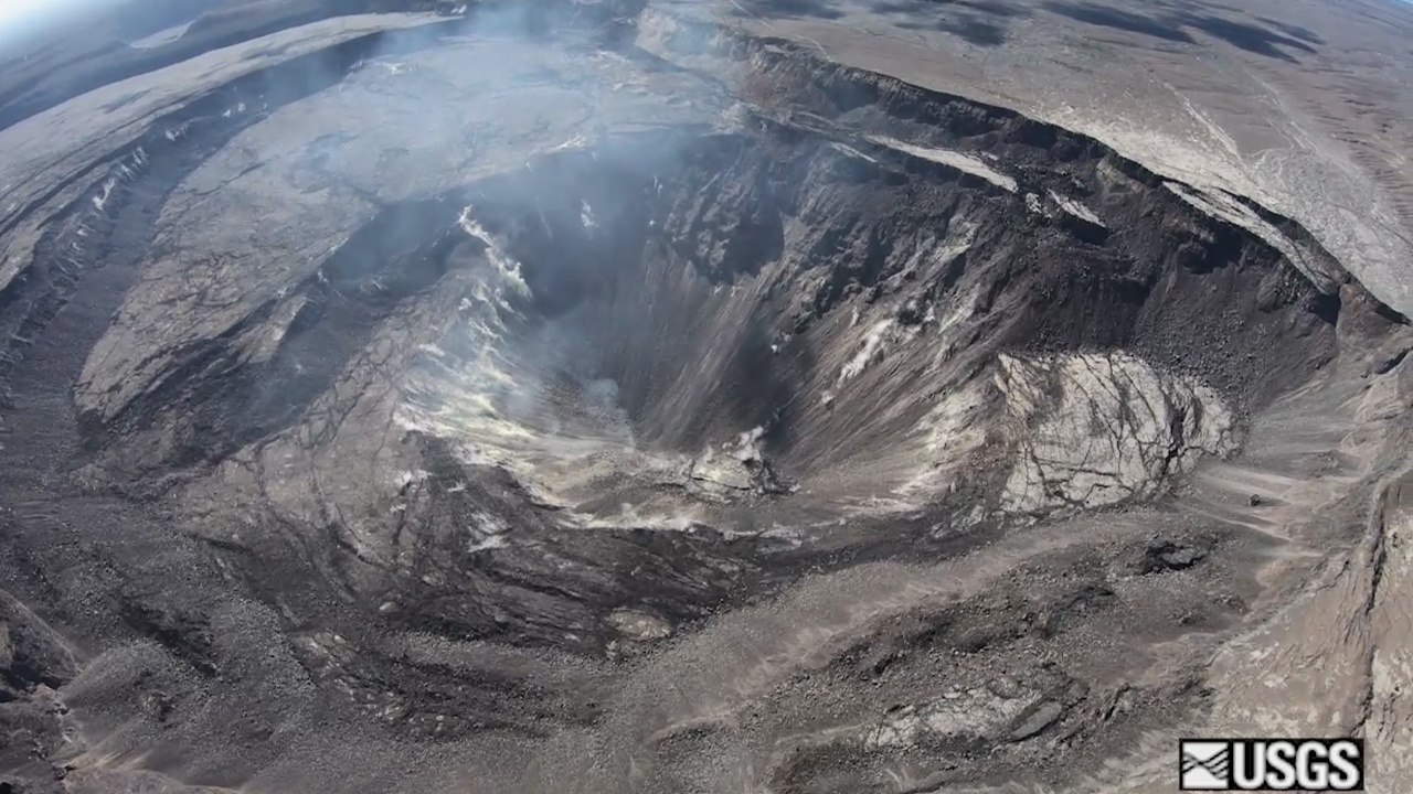
 www.bigislandvideonews.com
Big Island Video News Published on Apr 16, 2019 Published / 2:52
Related:

 spaceweatherarchive.com
Snip: 3-4 minute read:
And a discussion of past eruptions and impacts.
6-7 minute read:


VIDEO: Kilauea Volcano Monitoring Update
HAWAIʻI ISLAND - The USGS Hawaiian Volcano Observatory on Tuesday posted its weekly update for Kīlauea Volcano, which is not erupting.
 www.bigislandvideonews.com
Related:

Neutrons Detected on Commercial Airplane Flights
March 13, 2019: Long lines. Narrow seats. Baggage fees. You recognize this list. It’s the downside of flying on modern commercial airlines. And now we have a new item to add: cosmic ray neutr…
 spaceweatherarchive.com
March 13, 2019: Long lines. Narrow seats. Baggage fees. You recognize this list. It’s the downside of flying on modern commercial airlines. And now we have a new item to add: cosmic ray neutrons.
Spaceweather.com and Earth to Sky Calculus have just completed a 5-continent survey of neutron radiation at aviation altitudes. From December 2018 through February 2019, Hervey Allen of the University of Oregon’s Network Startup Resource Center carried Earth to Sky radiation sensors–including neutron bubble chambers–onboard commercial flights from North America to Europe, Africa, South America and Asia.
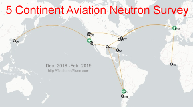
Hervey logged 83 hours in the air as he traveled 41,500 miles above 30,000 feet. For reference, that’s almost twice the circumference of the Earth. The entire time, he gathered data on X-rays, gamma-rays and neutrons in an energy range (10 keV to 20 MeV) similar to that of medical radiology devices and “killer electrons” from the Van Allen Radiation Belts.
The results were eye-opening: (Contained)
And a discussion of past eruptions and impacts.
6-7 minute read:
New volcano eruption observed in Mount Aso in Japan
April 19, 2019
Published on Apr 18, 2019 (13:04)
A new volcano eruption has been observed on Mount Aso in Japan's Kumamoto Prefecture, Japan Meteorological Agency said on Friday.
This is the second eruption on Mount Aso this week. Local authorities have urged residents to stay away from the volcano.
No disruption to air service have been reported.
At 1,592 meters, Mount Aso is one of the largest volcanoes in the world.
Last eruption of Colima´s volcano (Mexico) aka Volcán de Fuego-Fire Volcano, was in 2017. Would not doubt, if erupts again in further months.
https://www.facebook.com/SkyAlertMx/photos/a.282374375131749/2186052848097216/?type=3&theater said:In the last week #VolcánDeColima increased activity:
Weekly report:
60 volanotectonic earthquakes. (13 weeks prior).
25 LP's earthquakes (exhalations)
43 min of tremor.
Although increased seismicity does not generate visible activity in the crater, these signs have been observed prior to explosions and/or growth of a new dome.
Information:
RESCO-CUEV-Faculty of Sciences
University of Colima
--using deeple.com

Volcanoes, climate and social changes. - Earth of fire
Various historical documents recount the observation of a "mysterious cloud" observed from March 536 in the Mediterranean regions. This cloud has covered the region for about 18 months. The cooling of the northern hemisphere was described by Procopius...
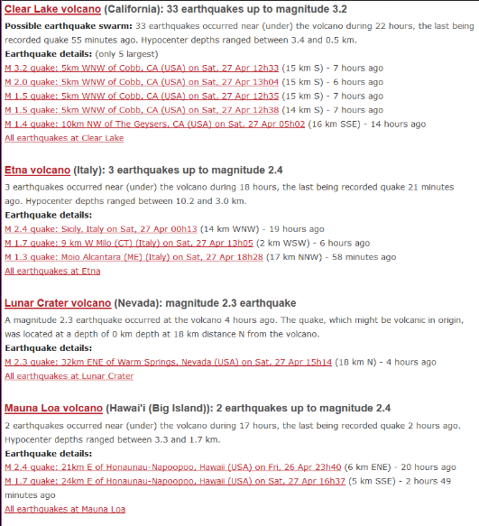
Yeah, your intuition, and the data, make it a good possibility.Last eruption of Colima´s volcano (Mexico) aka Volcán de Fuego-Fire Volcano, was in 2017. Would not doubt, if erupts again in further months.
Seems the planet is vibrating like it's about ready to split a seam.
Like the C's say, a slowing rotation with other less know influences being at work as well.
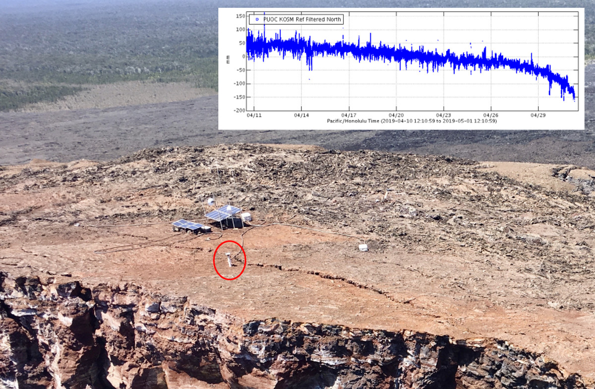
GPS Instrument Lost In Small Puu Oo Crater Collapse
HAWAIʻI ISLAND - Scientists say a small collapse of the Pu‘u ‘Ō‘ō crater at 6:14 a.m. HST Wednesday was the last 'hurrah' for a GPS instrument located on the crater's edge.
 www.bigislandvideonews.com

A small collapse of the Pu‘u ‘Ō‘ō crater at 6:14 a.m. HST today (May 1, 2019) was the last 'hurrah' for a GPS instrument located on the crater's edge (red circle).
This station, designated PUOC, served faithfully throughout Kīlauea's 2018 eruption and was an important source of information on the shallow magma system of Pu‘u ‘Ō‘ō. The station's last reported position showed it moving rapidly to the southeast, consistent with motion into the crater (inset shows data transmissions from April 11 through this morning). Monitoring of Pu‘u ‘Ō‘ō is currently being accomplished by additional GPS and tilt stations farther from the edge of the crater.
The larger equipment installation near the solar panels was not affected by this morning's collapse and continues to function. However, contingency plans are in place in case collapses of the crater edge continue. USGS photo by Ingrid Johanson on March 18, 2019, annotated on May 1, 2019.
Translated from Spanish by Microsoft
Ult 24 h:
• 44 exhalation.
• 0 explosions.
• 1 VT earthquake (Mc 3.1).
• 95 min tremor.
«
Translated from Spanish by Microsoft
• San Nicolás
• Atlixco
• Huaquechula
• Tlapanalá
• Huejotzingo
• Texmelucan
• Sn Andrés Cholula
• Coronango
• Puebla Valid next 12 H.
Translated from French by Microsoft

Un point sur l'activité des volcans Colima et Etna (mis à jour)
Un point sur l'activité des volcans Colima et Etna; 02 mai 2019
Kamchatka and the Kuriles volcanoes: Erupting or Restless
Information Release, May 01, 2019. KVERT
| (11) Volcanic Activity Summary: | A moderate explosive activity of the volcano continues. Visual data from Severo-Kurilsk showed an explosion sent ash up to 3.0 km a.s.l., an ash cloud is drifting to the southeast of the volcano. A moderate eruptive activity of the volcano continues. Ash explosions up to 19,700 ft (6 km) a.s.l. could occur at any time. Ongoing activity could affect low-flying aircraft and airport of Severo-Kurilsk. |
| (12) Volcanic cloud height: | 9840 ft (3000 m) AMSL Time and method of ash plume/cloud height determination: 20190501/0204Z – Visual data |
caballero reyes
The Living Force
Redacción ADN40
domingo 5, mayo 2019
@adn40
Foto: globalbrain_
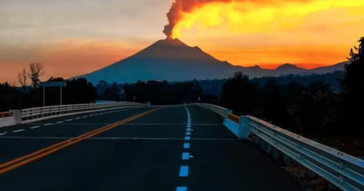
 www.adn40.mx
The National Center for Disaster Prevention (Cenapred) reported on the activity of Popocatépetl in the last 24 hours; presented 56 exhalations, an explosion, two volcanotectonic earthquakes and five minutes of tremor.
The Volcanic Warning Semaphore remains in yellow phase 3. The population is urged not to approach the volcano.
domingo 5, mayo 2019
@adn40
Foto: globalbrain_

Popocatépetl presentó dos sismos volcánicos en las últimas 24 horas
El Semáforo de Alerta Volcánica permanece en amarillo fase 3. Se exhorta a la población a no acercarse al volcán.
The National Center for Disaster Prevention (Cenapred) reported on the activity of Popocatépetl in the last 24 hours; presented 56 exhalations, an explosion, two volcanotectonic earthquakes and five minutes of tremor.
The Volcanic Warning Semaphore remains in yellow phase 3. The population is urged not to approach the volcano.
Trending content
-
Thread 'Coronavirus Pandemic: Apocalypse Now! Or exaggerated scare story?'
- wanderingthomas
Replies: 30K -
-
-
