You are using an out of date browser. It may not display this or other websites correctly.
You should upgrade or use an alternative browser.
You should upgrade or use an alternative browser.
Volcanoes Erupting All Over
- Thread starter Laura
- Start date
EmeraldR
The Living Force
wow !Mount Etna in Sicily is blowing smoke rings or rare volcanic vortex smoke rings into the sky:

Mount Etna in Sicily is blowing smoke rings or rare volcanic vortex smoke rings into the sky:
wow !
Not only that, Etna is producing thousands of them currently, which is unprecedented:
According to experts, however, the phenomenon on Mount Etna has reached an unprecedented dimension in recent days.
NOTICE
Mount #Ruang erupts in the northern #Sangihe islands of #Indonesia
The eruptive pulse of this stratovolcano occurred today April 17 at 01:08 local time.
Via @id_magma


Strong eruption of Ruang volcano
I have marveled at the power of the eruptions and they never cease to amaze me. Wow.
With a level IV alert status, Mount Ruang on Ruang Island, North Sulawesi, has erupted again.
Yeah, pretty impressive.
Here's another shot (on min 21 you see big lightning&thunder and one big burst). Just like Pierre explained in Earth Changes, the electric Universe at play.
Here's another shot (on min 21 you see big lightning&thunder and one big burst). Just like Pierre explained in Earth Changes, the electric Universe at play.
I took a print screen of the lightning from a wider version of that video (found on the Twitter link, which redirects to FB).

XPan
The Living Force
Kilauea, Hawai'i
4 May 2024
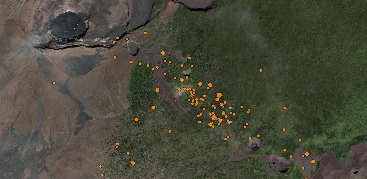
Apparently, the Kilauea volcano has become more unsettled in terms of swarm earthquakes which now appear along the "Chain of Crater Road" (which is closed). Some of the already existing pit craters are really deep, when I visited those places back in 2011 along that road - stunned by the vast dimensions those craters actually showed. They look rather small in the satellite image.
German Vulkane.net wrote an article as follow:

Increased seismicity at Kilauea - particularly many earthquakes in the south-east drift
Over the past week, there have been more than 300 weak earthquakes at Kilauea every day for five consecutive days. While in the first days of increased activity the earthquakes manifested themselves at two locations to the south and south-east of the caldera, in the last few days the earthquakes were concentrated in the south-east drift. Initially, there were only earthquakes in the upper part of the rift. In the meantime, however, they have migrated further down the slope towards Puʻuʻōʻō crater, but without reaching it completely. The next quakes came within about 1000 metres of this crater, which was active between 1983 and 2018.
More specifically, most of the earthquakes manifested themselves between the south-east side of the caldera and below the Keanakākoʻi crater up to the junction with the Hilina-Pali Road. There were about 280 earthquakes in this area within one day. The earthquake foci were between 2 and 3 kilometres deep. Most of the quakes had magnitudes of less than M 2.0. The day before yesterday there was a 30-minute phase with stronger earthquakes. The largest magnitude was M 3.1, which could be felt by residents of the communities near the summit.
The earthquakes are accompanied by increased ground uplift caused by magma intrusions into the shallow subsurface of the zones described.
The HVO writes that the ground deformation continues with the ongoing uplift under Halemaʻumaʻu and in the region extending from the southern end of Kalaupele to the area south of the Keanakākoʻi crater.
At this stage, it is not possible to say with certainty whether this increase in activity will lead to the formation of a magmatic vein or even a volcanic eruption in the near future, but normally such periods of activity are omens that an eruption or vein formation will occur in the next few days or weeks. Based on previous activity in the upper east rift zone, it is more likely that the current activity will lead to an intrusion rather than an eruption. However, changes in the location of the unrest and the possibility of an eruption can occur quickly.
END OF ARTICLE
4 May 2024
Apparently, the Kilauea volcano has become more unsettled in terms of swarm earthquakes which now appear along the "Chain of Crater Road" (which is closed). Some of the already existing pit craters are really deep, when I visited those places back in 2011 along that road - stunned by the vast dimensions those craters actually showed. They look rather small in the satellite image.
Kilauea: Hohe Seismizität am Südostrift - Vulkane Net Newsblog
Am Vulkan Kilauea auf Hawaii ist die Seismizität erhöht. Besonders viele Erdbeben gibt es im Südostrift bis zum Puʻuʻōʻō-Krater.
www.vulkane.net
German Vulkane.net wrote an article as follow:
Increased seismicity at Kilauea - particularly many earthquakes in the south-east drift
Over the past week, there have been more than 300 weak earthquakes at Kilauea every day for five consecutive days. While in the first days of increased activity the earthquakes manifested themselves at two locations to the south and south-east of the caldera, in the last few days the earthquakes were concentrated in the south-east drift. Initially, there were only earthquakes in the upper part of the rift. In the meantime, however, they have migrated further down the slope towards Puʻuʻōʻō crater, but without reaching it completely. The next quakes came within about 1000 metres of this crater, which was active between 1983 and 2018.
More specifically, most of the earthquakes manifested themselves between the south-east side of the caldera and below the Keanakākoʻi crater up to the junction with the Hilina-Pali Road. There were about 280 earthquakes in this area within one day. The earthquake foci were between 2 and 3 kilometres deep. Most of the quakes had magnitudes of less than M 2.0. The day before yesterday there was a 30-minute phase with stronger earthquakes. The largest magnitude was M 3.1, which could be felt by residents of the communities near the summit.
The earthquakes are accompanied by increased ground uplift caused by magma intrusions into the shallow subsurface of the zones described.
The HVO writes that the ground deformation continues with the ongoing uplift under Halemaʻumaʻu and in the region extending from the southern end of Kalaupele to the area south of the Keanakākoʻi crater.
At this stage, it is not possible to say with certainty whether this increase in activity will lead to the formation of a magmatic vein or even a volcanic eruption in the near future, but normally such periods of activity are omens that an eruption or vein formation will occur in the next few days or weeks. Based on previous activity in the upper east rift zone, it is more likely that the current activity will lead to an intrusion rather than an eruption. However, changes in the location of the unrest and the possibility of an eruption can occur quickly.
END OF ARTICLE
XPan
The Living Force
Phillipines volcanoes
4 May 2024
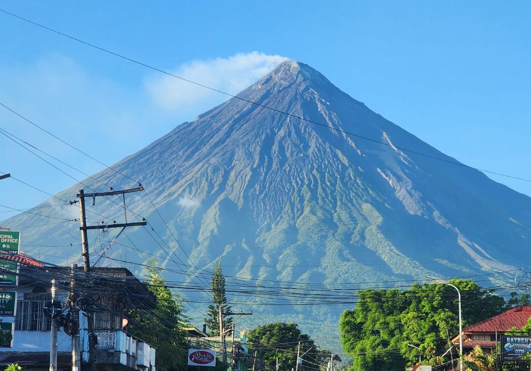

In the Philippines, the Kanlaon, Mayon and Taal volcanoes are showing signs of increased unrest - volcanic eruptions are imminent
The Philippine archipelago lies on the Circumpacific Ring of Fire, along which earthquakes and volcanic eruptions are increasingly occurring. The reason for this is the boundary between the Pacific Plate and the neighbouring earth crust plates, along which subduction predominantly occurs. There are numerous earthquakes here every day. Just yesterday, a magnitude 5.8 earthquake with an epicentre at a depth of 13 kilometres manifested itself in the Philippine region of Leyte. The PHILVOLCS observatory not only reports on earthquakes, but also on volcanic events in the archipelago and has highlighted the activity of three volcanoes in recent days.
One of these volcanoes is Mayon
which was often in the headlines last spring as it experienced a phase of strong dome growth and lava flows from the dome. Collapse events at the lava front triggered smaller pyroclastic flows. After a few months, the activity subsided, but now it looks as if new dome growth is beginning. In recent days, volcanologists have increasingly observed weak red heat at the summit and debris avalanches. Occasional volcanotectonic earthquakes have occurred and ground uplift has been detected. These are all signs that magma is rising.
Kanalon volcano
Increased emissions of sulphur dioxide were detected at Kanlaon at the end of April, which can also be a sign of magma ascent. Similar to Mayon, ground uplift is occurring and the volcanic edifice is inflating as a result. It already started two years ago, but in recent months the uplift of the eastern flank of the volcano has accelerated.
Taal volcano
The third Philippine volcano showing signs of increased activity is Taal. There was another phreatic eruption here on 1 May. In addition, seismicity has increased in recent weeks, which is the real novelty of what is happening. Yesterday there were six volcanic-related earthquakes. Five of these events were tremor phases, which indicate fluid movements in the shallow subsurface. The sulphur dioxide emission was 2700 tonnes per day, which is generally a high value, but rather low for the Taal. Deflation is measured in the area of the entire caldera, but inflation is measured for Volcano Island. Even if a major volcanic eruption is rather unlikely, magmatic eruptions could still occur. Steam-driven phreatic eruptions, as we have seen more frequently in recent weeks, will most likely continue to occur sporadically.
END OF ARTICLE
4 May 2024
Philippinen: Mehrere Vulkane sind unruhig - Vulkane Net Newsblog
Auf den Philippinen zeigen die Vulkane Kanlaon, Mayon und Taal Anzeichen erhöhter Unruhe. Vulkanausbrüche drohen.
www.vulkane.net
In the Philippines, the Kanlaon, Mayon and Taal volcanoes are showing signs of increased unrest - volcanic eruptions are imminent
The Philippine archipelago lies on the Circumpacific Ring of Fire, along which earthquakes and volcanic eruptions are increasingly occurring. The reason for this is the boundary between the Pacific Plate and the neighbouring earth crust plates, along which subduction predominantly occurs. There are numerous earthquakes here every day. Just yesterday, a magnitude 5.8 earthquake with an epicentre at a depth of 13 kilometres manifested itself in the Philippine region of Leyte. The PHILVOLCS observatory not only reports on earthquakes, but also on volcanic events in the archipelago and has highlighted the activity of three volcanoes in recent days.
One of these volcanoes is Mayon
which was often in the headlines last spring as it experienced a phase of strong dome growth and lava flows from the dome. Collapse events at the lava front triggered smaller pyroclastic flows. After a few months, the activity subsided, but now it looks as if new dome growth is beginning. In recent days, volcanologists have increasingly observed weak red heat at the summit and debris avalanches. Occasional volcanotectonic earthquakes have occurred and ground uplift has been detected. These are all signs that magma is rising.
Kanalon volcano
Increased emissions of sulphur dioxide were detected at Kanlaon at the end of April, which can also be a sign of magma ascent. Similar to Mayon, ground uplift is occurring and the volcanic edifice is inflating as a result. It already started two years ago, but in recent months the uplift of the eastern flank of the volcano has accelerated.
Taal volcano
The third Philippine volcano showing signs of increased activity is Taal. There was another phreatic eruption here on 1 May. In addition, seismicity has increased in recent weeks, which is the real novelty of what is happening. Yesterday there were six volcanic-related earthquakes. Five of these events were tremor phases, which indicate fluid movements in the shallow subsurface. The sulphur dioxide emission was 2700 tonnes per day, which is generally a high value, but rather low for the Taal. Deflation is measured in the area of the entire caldera, but inflation is measured for Volcano Island. Even if a major volcanic eruption is rather unlikely, magmatic eruptions could still occur. Steam-driven phreatic eruptions, as we have seen more frequently in recent weeks, will most likely continue to occur sporadically.
END OF ARTICLE
XPan
The Living Force
Reykjanes/Grindavik, Iceland
3 May 2024
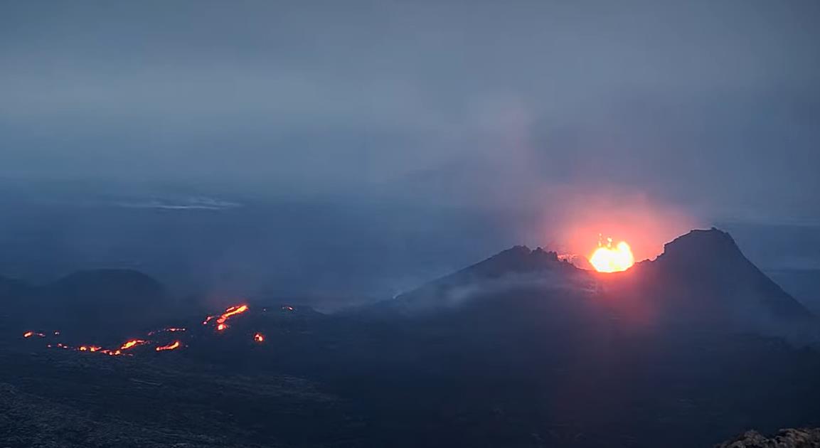
The eruption is still ongoing, albeit weak - there are clear signs of unrest.

Increase in earthquake activity on Reykjanes - tensions rise
Slowly but steadily, earthquake activity under the Reykjanes peninsula on Iceland is increasing. This is an indication that the tensions in the ground are increasing, triggered by the ongoing ground uplift at Svartsengi. Magma is accumulating here at a depth of around 5 kilometres. The speed of the uplift is largely constant. A suspected decrease at the weekend was not confirmed, and so the tension is slowly rising among those who have been following the events on Iceland for months. It seems to be less a question of whether something will happen than when a new intrusion will occur, which could even culminate in another volcanic eruption. Volcanologists suspect that there could be another fissure opening in the area of the current eruption or that it could intensify.

The eruption itself is continuing, and subjectively speaking, the volcano seemed a little more active to me this morning than before. During the night, a small lava flow broke through and made its way along the western base of the crater cone. Even if there is only a little melt on the surface, lava is still flowing through underground tunnels, so that the lava field near the crater is becoming increasingly thicker. A new Sentinel image shows weak thermal radiation from a lava front on the surface near the dam in the north of Grindavik.
If you take a closer look at the earthquake map of Iceland, you can also recognise increased earthquake activity in the Vatnajökull area. There were some tremors near Grimsfjall and Öræfajökull, where the third large volcanic massif is hidden under Vatnajökull.
Within 48 hours, IMO detected 180 tremors under the whole of Iceland. 121 tremors occurred under Reykjanes. Many of these quakes were in the area of the magmatic vein at Sundhnúkur, but the fissure systems of Fagradalsfjall and Krysúvik also shook frequently. Some of the tremors had magnitudes in the range of two. This means that not only the number of quakes is increasing, but also their strength.
END OF ARTICLE
3 May 2024
The eruption is still ongoing, albeit weak - there are clear signs of unrest.
Island: Erdbebenaktivität am 3. Mai erhöht - Vulkane Net Newsblog
Langsam aber stetig nimmt die Erdbebenaktivität unter der Reykjaneshalbinsel auf Island zu. Die Spannungen im Boden steigen.
www.vulkane.net
Increase in earthquake activity on Reykjanes - tensions rise
Slowly but steadily, earthquake activity under the Reykjanes peninsula on Iceland is increasing. This is an indication that the tensions in the ground are increasing, triggered by the ongoing ground uplift at Svartsengi. Magma is accumulating here at a depth of around 5 kilometres. The speed of the uplift is largely constant. A suspected decrease at the weekend was not confirmed, and so the tension is slowly rising among those who have been following the events on Iceland for months. It seems to be less a question of whether something will happen than when a new intrusion will occur, which could even culminate in another volcanic eruption. Volcanologists suspect that there could be another fissure opening in the area of the current eruption or that it could intensify.
The eruption itself is continuing, and subjectively speaking, the volcano seemed a little more active to me this morning than before. During the night, a small lava flow broke through and made its way along the western base of the crater cone. Even if there is only a little melt on the surface, lava is still flowing through underground tunnels, so that the lava field near the crater is becoming increasingly thicker. A new Sentinel image shows weak thermal radiation from a lava front on the surface near the dam in the north of Grindavik.
If you take a closer look at the earthquake map of Iceland, you can also recognise increased earthquake activity in the Vatnajökull area. There were some tremors near Grimsfjall and Öræfajökull, where the third large volcanic massif is hidden under Vatnajökull.
Within 48 hours, IMO detected 180 tremors under the whole of Iceland. 121 tremors occurred under Reykjanes. Many of these quakes were in the area of the magmatic vein at Sundhnúkur, but the fissure systems of Fagradalsfjall and Krysúvik also shook frequently. Some of the tremors had magnitudes in the range of two. This means that not only the number of quakes is increasing, but also their strength.
END OF ARTICLE
XPan
The Living Force
Rincon de la Vieja, Costa Rica
3 May 2024
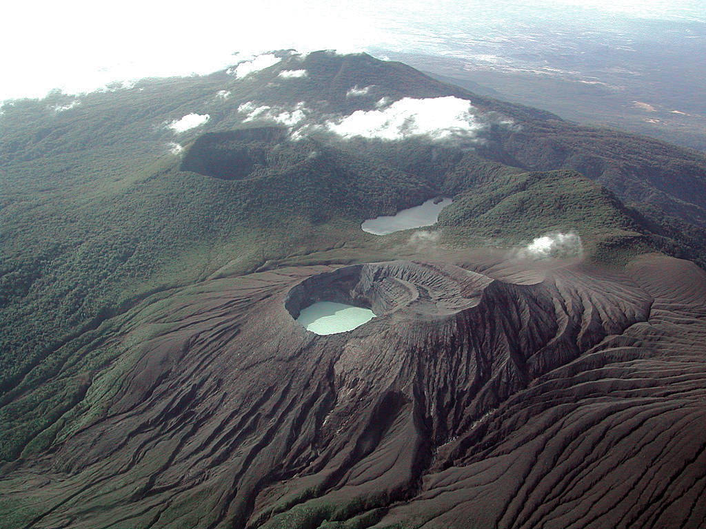

Rincon de la Vieja heats up in Costa Rica - volcanic eruption threatens holiday paradise
The Rincón de la Vieja volcano is showing signs of increased seismic activity and an expansion or uplift of its crater. This is according to a note from the responsible observatory OVSICORI-UNA. According to the note, volcanotectonic earthquakes and tremors have been detected, the amplitude of which has increased in recent days. Infrasound signals indicate explosive degassing and a dense cloud of vapour is rising several hundred metres high. However, there have been no explosions so far.
Volcanologists interpret these signs as indications of the possible presence of magma less than 5 kilometres below the surface. This could be due to increased pressure of the gases and possibly indicate a minor magmatic intrusion. Ultimately, a volcanic eruption could occur. At least phreatic eruptions are possible at any time.

While Rincon de la Vieja is increasing its activity
the same appears to be decreasing at Poás volcano, where the proportion of ash particles in the gas emissions has decreased. "The day before yesterday, the ash emission began to gradually decrease, and today we are observing a cloud of volcanic gases and water vapour, with significantly less ash," explained OVSICORI-UNA volcanologist Bakkar. The LiveCam currently shows strong degassing from the dry crater, which was home to a crater lake until autumn. Due to a dry period and increased geothermal activity, the crater lake dried up.
Rincon de la Vieja is located in a national park known for its tropical dry forest, where many rare animal species are protected. These animals include sloths and armadillos. The national park is a popular tourist destination, mainly visited by American tourists.
The 1916 metre high complex volcano is located in the north-west of Costa Rica and is one of the most active fire mountains in Latin America. The last major eruptions occurred in 1995 and 1998, when the crater with the crater lake, which is part of the Santa Maria complex, was active. The explosions were so powerful that the water in the crater lake spilled over its rim and triggered lahars. A similar scenario could be in the offing now. Phreatic eruptions have been occurring repeatedly since 2011.
END OF ARTICLE
3 May 2024
Vulkan Rincon de la Vieja heizt auf - Vulkane Net Newsblog
Rincon de la Vieja in Costa Rica heizt auf und die Erdbebentätigkeit ist erhöht. Ein Vulkanausbruch droht im Urlaubsparadies.
www.vulkane.net
Rincon de la Vieja heats up in Costa Rica - volcanic eruption threatens holiday paradise
The Rincón de la Vieja volcano is showing signs of increased seismic activity and an expansion or uplift of its crater. This is according to a note from the responsible observatory OVSICORI-UNA. According to the note, volcanotectonic earthquakes and tremors have been detected, the amplitude of which has increased in recent days. Infrasound signals indicate explosive degassing and a dense cloud of vapour is rising several hundred metres high. However, there have been no explosions so far.
Volcanologists interpret these signs as indications of the possible presence of magma less than 5 kilometres below the surface. This could be due to increased pressure of the gases and possibly indicate a minor magmatic intrusion. Ultimately, a volcanic eruption could occur. At least phreatic eruptions are possible at any time.
While Rincon de la Vieja is increasing its activity
the same appears to be decreasing at Poás volcano, where the proportion of ash particles in the gas emissions has decreased. "The day before yesterday, the ash emission began to gradually decrease, and today we are observing a cloud of volcanic gases and water vapour, with significantly less ash," explained OVSICORI-UNA volcanologist Bakkar. The LiveCam currently shows strong degassing from the dry crater, which was home to a crater lake until autumn. Due to a dry period and increased geothermal activity, the crater lake dried up.
Rincon de la Vieja is located in a national park known for its tropical dry forest, where many rare animal species are protected. These animals include sloths and armadillos. The national park is a popular tourist destination, mainly visited by American tourists.
The 1916 metre high complex volcano is located in the north-west of Costa Rica and is one of the most active fire mountains in Latin America. The last major eruptions occurred in 1995 and 1998, when the crater with the crater lake, which is part of the Santa Maria complex, was active. The explosions were so powerful that the water in the crater lake spilled over its rim and triggered lahars. A similar scenario could be in the offing now. Phreatic eruptions have been occurring repeatedly since 2011.
END OF ARTICLE
Trending content
-

-
Thread 'Coronavirus Pandemic: Apocalypse Now! Or exaggerated scare story?'
- wanderingthomas
Replies: 30K -
