Earthquakes around the world

WORLDWIDE EARTHQUAKE REPORT SEPTEMBER 10

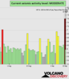
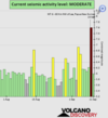
Based on the averages of all earthquakes during the last 24 hours we had a EXTREME seismic activity level. (First time I see this level) See Global seismic activity level chart
chrome_screenshot_1662855339528.png
~1 quake above magnitude 7
~1 quakes above magnitude 6
~2 quakes between magnitude 5 and 6
~37 quakes between magnitude 4 and 5
~146 quakes between magnitude 3 and 4
~381 quakes between magnitude 2 and 3
~1213 quakes below magnitude 2 that people normally don't feel.
~1781 quakes past 24 h. (2255 earthquakes in the 24 hours prior to this report) Estimated combined seismic energy released: 1.6 x 10¹⁶ joules (4439 gigawatt hours, equivalent to 3.8 x 10⁶ tons of TNT or 238.7 atomic bombs!)
Volcanodiscovery earthquake report 24h

Strong earthquake M 7.6 - 67 km E of Kainantu, Papua New Guinea
2022-09-10 23:46:55 (UTC)
6.224°S 146.471°E. 61.4 km depth
USGS earthquake alert

Papua New Guinea was shaken near Lae, Morobe Province, by an earthquake of magnitude 7.6 31 minutes ago, the United States Geological Survey reported.
The quake hit at a moderately shallow depth of 61.4 km beneath the epicenter near Lae, Morobe Province, Papua New Guinea, in the morning on Sunday, September 11th, 2022, at 9:46 am local time. Magnitude and other quake parameters can still change in the coming hours as the agency continues to process seismic data.

Estimated energy1.6 x 1016 joules (4402 gigawatt hours, equivalent to 3.8 x 10⁶ tons of TNT or 236.7 atomic bombs!)

Data for the same earthquake reported by different agencies​

Info: The more agencies report about the same quake and post similar data, the more confidence you can have in the data. It takes normally up to a few hours until earthquake parameters are calculated with near-optimum precision.
Mag.DepthLocationSource
7.661 km68 Km NW of Lae, Papua New GuineaUSGS
7.680 kmPapua New Guinea: EASTERN NEW GUINEA REG., P.N.G.EMSC
7.661 kmPapua New Guinea: Eastern New Guinea Reg., P.N.G.RaspberryShake
7.110 kmPapua New Guinea: Near Port MoresbyRENASS
7.610 kmPapua New Guinea RegionGFZ
7.677 kmPapua New Guinea: Eastern New Guinea Reg., P.N.G.GeoAu
7.491 kmPapua New Guinea [Land]INGV
Volcanodiscovery earthquake report 24h
 
▪︎Tsunami information statement after earthquake M7.6 in Papua New Guinea


▪︎M 5.0 - 54 km NNE of Kainantu, Papua New Guinea
2022-09-11 00:42:37 (UTC)
5.814°S 146.008°E. 101.4 km depth
USGS earthquake alert

▪︎Iceland

Update: The Iceland sequence continues. Approaching the 48-hour mark, OMI has recorded about 2,800 earthquakes, including an M4.0-4.6 a few hours ago. Swarms like this are common in the region.

▪︎France
"ALERT - Earthquake of magnitude 4.8 near Mulhouse , strongly felt a few minutes ago in Alsace and Switzerland (French Seismological Central Office)."
Based on the preliminary seismic data, the quake was probably felt by many people in the area of the epicenter. It should not have caused significant damage, other than objects falling from shelves, broken windows, etc.
In Brunstatt (pop. 5,800) located 3 km from the epicenter, Mulhouse (pop. 111,400) 6 km away, Illzach (pop. 15,500) 8 km away, and Wittenheim (pop. 15,700) 12 km away, the quake should have been felt as light shaking.
Weak shaking might have been felt in St. Louis (pop. 20,900) located 21 km from the epicenter, Basel (pop. 164,500) 24 km away, Belfort (pop. 54,600) 37 km away, and Colmar (pop. 65,400) 42 km away.
Other towns or cities near the epicenter where the quake might have been felt as very weak shaking include Strasbourg (pop. 274,800) located 103 km from the epicenter.

Largest earthquakes in or near Mulhouse, Grand Est, France, on record since 1900:

~5 quakes above magnitude 5
~70 quakes between magnitude 4 and 5
~621 quakes between magnitude 3 and 4

~Strongest quake near Mulhouse: Mag. 5.5 Switzerland - 68 years ago

~Today: Mag. 4.3 on Saturday, Sep 10, 2022 at 5:58 pm (GMT +2) – 5.7 km S of Mulhouse, Haut-Rhin, Grand Est, France

~Estimated energy: 7.1 x 10¹¹ joules (197 megawatt hours, equivalent to 169 tons of TNT)
Volcanodiscovery
 
Basel - Mulhouse - Freiburg (Corner of France, Switzerland & Germany)
10 Sep 2022

Puma already reported from the technical & tectonic details regarding the earthquake, reported as M 4.3, others M 4.7. Here is more background information about this active seismic region in the three border corner, especially given that it is planned to store nuclear waste in that area. Another one of those "smart" ideas in the Region ? :rolleyes:

Vulkane.net reported following:


1b90bed_1662826867237-mapserv.png.jpg

Earthquake Ml 4.7 shakes border region near Basel-Mühlhausen-Freiburg
by Marc Szeglat


Date: 10 Sep 2022 | Time: 15:58:13 UTC | Location: 47.68 N ; 7.48 E | Depth: 10 km | Ml 4.7

The border triangle between France, Switzerland and Germany was shaken by a magnitude 4.7 earthquake. The hypocentre was located at a depth of 10 km. The epicentre was located 14 km east of Mulhouse, and 15 northwest of Basel. The next largest city on German soil is Freiburg. The earthquake could be felt over a large radius and had the potential to cause minor building damage.


Earthquake near planned nuclear waste repository in Switzerland-Germany border region

The earthquake is a reminder that strong earthquakes can occur in the Upper Rhine Graben. In 1356, a strong earthquake occurred near Basel that had a magnitude between 6 and 7 and left the city in ruins. Of all places, Switzerland is planning a nuclear waste repository in this area.

As luck would have it, the earthquake occurred around the time when the Swiss nuclear authorities announced the location for their planned nuclear waste repository in Hohentengen. Not only is the region close to the border with Germany, it is also less than 50 km as the crow flies from the epicentre of the earthquake. It is illusory to believe that there would be a truly safe repository for nuclear waste anyway, but to locate it in an earthquake region of all places is more than negligent! Should a major radiation leak occur, the Lake Constance region would be contaminated. One of the most beautiful landscapes in Germany and an important water reservoir. The old volcanoes of the Hegau are also not far from the planned repository. An area that is anything but geologically stable!


Nuclear power plants during the energy crisis

This chain of thought now leads me inevitably to the energy crisis in Germany. Although I do not welcome nuclear energy, I think it is political madness to stick to the final phase-out of nuclear energy this year. If technically possible, I think we should leave the 3 remaining nuclear power plants running until the energy crisis subsides.

The problems we could face in a power blackout cascade are greater than the probability of a super blackout within a few months/years. However, it could become problematic to keep the reactors cool if there is a prolonged blackout and the backup systems also fail. Even if a nuclear power plant shuts down, the fuel rods will be so hot for months that they will need to be actively cooled. If the cooling fails, a meltdown could still occur. One question that arises, of course, is where Germany should get enough uranium so quickly to keep it running for a few more months. So far, much of the fissile material has come from scrapped nuclear weapons from Russia. Apart from that, Germany does not yet know what to do with the nuclear waste. Crazy world!


END OF ARTICLE

Another Article gives some information about Earthquakes in general in Switzerland.

The Earth shook on Saturday afternoon in the Basel region.

The epicenter of the earthquake, 4.7 on the Richter scale, was in Mulhouse (F), indicates on its website the Swiss Seismological Service. It was felt in a good part of French-speaking Switzerland, within a radius of more than 180 kilometers, specifies the Seismological Service. It happened shortly before 6 p.m. Three aftershocks between 1.2 and 2.8 followed until 7 p.m.

For the time being, no serious damage has been reported in France, according to AFP. According to the first elements and GPS data from the Renass National Seismic Monitoring Network, based in Strasbourg, the earthquake occurred at Schlierbach, south of Mulhouse. The epicenter was located about 12 kilometers deep, according to the same source. The tremors were felt over a wide radius. On its site, the Renass thus reported testimonies up to 230 km from the epicenter.

Whenever

The earth had already shaken earlier in the afternoon in the Alps. From noon with values between 0.9 and 2.5, the earthquakes were located in the Petit Combin region, near Orsières (VS) and Chamonix, adds the Seismological Service.

Of the 1000 to 1500 earthquakes that occur each year in Switzerland (656 in 2023), the population only feels 10 to 20.
These earthquakes generally have magnitudes of 2.5 or more. On the long-term average, 23 earthquakes with a magnitude equal to or greater than 2.5 are observed each year. The probability of a catastrophic earthquake with a magnitude of 6 or greater is 1% for the next year. On average, such an event should be expected every 50 to 150 years. An earthquake of this strength [6+] last occurred in 1946 near Sierre (VS). An earthquake of at least magnitude 5 occurs approximately every 8 to 15 years.

The last earthquake that caused significant damage in Switzerland occurred in 1991 in Vaz in the canton of Grisons, with a magnitude of 5.

With a magnitude of approximately 6.6, the strongest earthquake historically documented in Switzerland occurred produced 1356 near Basel

Séisme-de-Bâle-par-Karl-Jauslin-1842-1904.jpg
1356 Basel Earthquake imagined by Karl Jauslin (1842-1904)

earthquake-and-fire-in-basel1356.jpg
The fire following the Basel earthquake


Tremblement-de-Terre-de-Bale-gravure.png.jpeg
The engraving by Christian Wurstisen (1580). The city of Basel collapsed like a house of cards

Séismes-enregistrés-dans-le-Rhin-Supérieur.jpg

Recorded earthquakes in the Upper Rhine (source Rutsch.eu)


According to a seismic exercise reported by the website Rutsch, an earthquake similar to the one in Basel in 1356 would cause today :
  • A human toll of 1,000 to 6,000 people
  • 60,000 people would be injured to varying degrees
  • 1.6 million people homeless in the short term
  • 50% of buildings damaged
  • 45 to 90 billion euros of material damage
 
Last week saw 3 M6 earthquakes, with the largest being a M6.9 in the Mid Atlantic Ridge, between Brazil and West Africa.
In the usual area, there were 2 out of 97 earthquakes worldwide equal to or greater than 4.5 and 1705 out of 2102 quakes of all sizes.
Percentage: 81.1% (like last week)
Last week saw 5 M6 and one M7, which was a M7.6 in Papua New Guinea.
In the usual area, there was 1 out of 116 earthquakes worldwide equal to or greater than 4.5 and 1552 out of 1966 quakes of all sizes.
Percentage: 78.9%
Earthquakes 7 days to September 11th 2022.gif
 
Earthquake Forecast update

The seismic event in Papua New Guinea Region last night was a full magnitude higher than anticipated

Strong seismic activity up to around mid 6 magnitude was anticipated due to the lunar peak on 8 September that reached index 15, partially because of the convergence of a geocentric 45° angle between Jupiter and Saturn and 90° between Saturn and Uranus. In addition, a convergence of two 90° angles occurred early on 9 September involving Venus, Mercury and two outer planets. It resulted in a significant seismic increase on 9-10 September with four larger earthquakes peaking magnitude 7.5, a full magnitude higher than anticipated. The full moon in the morning of 10 September may have been an additional factor. SSGEOS

Harvest Moon: Full Moon in September 2022

When to See the Full Moon in September 2022

This year, look for September’s full Harvest Moon to appear just after sunset on Friday, September 9. It then reaches peak illumination at 5:58 A.M. Eastern Time on Saturday the 10th, drifting below the horizon shortly thereafter.

Why Is It Called the Harvest Moon?

The full Moon names used by The Old Farmer’s Almanac come from a number of places, including Native American, Colonial American, and European sources. Traditionally, each full Moon name was applied to the entire lunar month in which it occurred and through all of the Moon’s phases—not only the full Moon. The Harvest Moon, however, is a bit different!

The Harvest Moon

The full Moon that happens nearest to the fall equinox (September 22 or 23) always takes on the name “Harvest Moon.” Unlike other full Moons, this full Moon rises at nearly the same time—around sunset—for several evenings in a row, giving farmers several extra evenings of moonlight and allowing them to finish their harvests before the frosts of fall arrive. Read more about the Harvest Moon!

While September’s full Moon is usually known as the Harvest Moon, if October’s full Moon happens to occur closer to the equinox than September’s, it takes on the name “Harvest Moon” instead. In this case, September’s full Moon is referred to as the Corn Moon.


The last two weeks of September will be very critical due to a long series of critical planetary geometry, starting later today.

EARTHQUAKE WARNING: From 11 September to 2 October will be very critical due to a long series of critical planetary geometry. Seismic activity is expected to occur above average and may peak high 7 to 8+ magnitude, especially after the 21st.
 
WORLDWIDE EARTHQUAKE REPORT SEPTEMBER 11

Based on the averages of all earthquakes during the last 24 hours we had a moderate seismic activity level See Global seismic activity level chart

~5 quakes above magnitude 5
~49 quakes between magnitude 4 and 5
~112 quakes between magnitude 3 and 4
~272 quakes between magnitude 2 and 3
~901 quakes below magnitude 2 that people normally don't feel.
~1339 quakes past 24 h. (1781 earthquakes in the 24 hours prior to this report) Estimated combined seismic energy released: 4.6 x 10¹³ joules (12.7 gigawatt hours, equivalent to 10902 tons of TNT or 0.7 atomic bombs!)
Volcanodiscovery earthquake report 24h

▪︎Strongest earthquake today M5.5 - Fiji region
2022-09-11 09:06:51 (UTC)
20.975°S 178.945°W. 629.9 km depth
USGS earthquake alert

▪︎M 5.4 - south of Java, Indonesia
2022-09-11 04:16:32 (UTC)
11.076°S 110.854°E. 17.1 km depth
USGS earthquake alert

▪︎M 5.0 - 46 km NNW of Shimokizukuri, Japan
2022-09-11 21:21:53 (UTC)
41.202°N 140.148°E. 166.3 km depth
USGS earthquake alert

▪︎M 4.4 - Oaxaca-Veracruz border region, Mexico
2022-09-11 09:56:18 (UTC)
17.738°N 95.372°W. 115.3 km depth
USGS earthquake alert

M 4.1 - 1 km SW of Paltin, Romania
2022-09-11 16:08:18 (UTC)
45.771°N 26.700°E. 145.7 km depth
USGS earthquake alert
 

Attachments

  • chrome_screenshot_1662942248952.png
    chrome_screenshot_1662942248952.png
    316.2 KB · Views: 0
WORLDWIDE EARTHQUAKE REPORT SEPTEMBER 12

Based on the averages of all earthquakes during the last 24 hours we had a moderate seismic activity level See Global seismic activity level chart

~3 quakes above magnitude 5
~37 quakes between magnitude 4 and 5
~127 quakes between magnitude 3 and 4
~469 quakes between magnitude 2 and 3
~1446 quakes below magnitude 2 that people normally don't feel.
~2082 quakes past 24 h. (1339 earthquakes in the 24 hours prior to this report)
Volcanodiscovery earthquake report 24h

▪︎Strongest earthquake M 5.7 - 156 km E of Pondaguitan, Philippines
2022-09-12 08:14:39 (UTC)
6.178°N 127.578°E. 10.0 km depth
USGS earthquake alert

▪︎M 5.2 - 48 km E of Kainantu, Papua New Guinea
2022-09-12 15:00:11 (UTC)
6.288°S 146.302°E. 98.5 km depth
USGS earthquake alert

▪︎M 5.0 - Hokkaido, Japan region
2022-09-12 04:39:15 (UTC)
41.978°N 145.006°E. 10.0 km depth
USGS earthquake alert

▪︎ TJÖRNES FRACTURE ZONE VOLCANO, NORTH OF ICELAND ACTIVITY UPDATE

Tjornes_2.jpg

Tjörnes Fracture Zone (North of Iceland): (12 Sep) A seismic unrest has been occurring in the Tjörnes Fracture Zone since early September.

The Icelandic Meteorological Office (IMO) reported that more than 6000 earthquakes have been registered beneath Grímsey island so far, of which the strongest has been detected with magnitude M 4.9 on 8 September at 04:01 local time, widely felt on the north of Iceland.

The offshore Tjörnes Fracture Zone is an oblique transform zone that separates the northern volcanic zone of Iceland from the Kolbeinsey Ridge, part of the Mid-Atlantic Ridge north of Iceland.

The earthquake swarm has decreased in intensity. At least some scientists believe that the cause has been a magmatic intrusion in Iceland's northern rift zone that activated the Húsavík-Flatey (HFF) transform fault at the southern limit of the TFZ where the earthquakes were concentrated.
Volcanodiscovery

▪︎A boy helps his classmate evacuate the classroom during the past 6.6 magnitude earthquake on Sept. 5 in Sichuan, China.


Attachments

  • chrome_screenshot_1663023170913.png
    chrome_screenshot_1663023170913.png
    362.7 KB · Views: 0
WORLDWIDE EARTHQUAKE REPORT SEPTEMBER 13

Based on the averages of all earthquakes during the last 24 hours we had a moderate seismic activity level See Global seismic activity level chart

~6 quakes above magnitude 5
~55 quakes between magnitude 4 and 5
~109 quakes between magnitude 3 and 4
~306 quakes between magnitude 2 and 3
~1145 quakes below magnitude 2 that people normally don't feel.
~1621 quakes past 24 h. (2082 earthquakes in the 24 hours prior to this report) Estimated combined seismic energy released: 3.9 x 10¹³ joules (10.8 gigawatt hours, equivalent to 9286 tons of TNT or 0.6 atomic bombs!)
Volcanodiscovery earthquake report 24h

▪︎M 5.2 - Hokkaido, Japan region
2022-09-13 00:51:59 (UTC)
41.543°N 142.131°E. 58.6 km depth
USGS earthquake alert

▪︎M 5.2 - 110 km SE of Burica, Panama
2022-09-13 18:41:18 (UTC)
7.211°N 82.299°W. 11.4 km depth
USGS earthquake alert

▪︎M 4.7 - near the coast of Venezuela
2022-09-13 14:14:01 (UTC)
10.459°N 65.292°W. 7.9 km depth
USGS earthquake alert


▪︎Since the 10th an atmospheric 'dip' has been recorded almost every day at 12:00 UTC. If it's a seismic indicator it could point to Kamchatka/Kuril Islands, Tonga, maybe New Zealand and on the opposite side to Portugal/Mediterranean. This estimate does not exclude other regions.
 

Attachments

  • chrome_screenshot_1663115014296.png
    chrome_screenshot_1663115014296.png
    348.6 KB · Views: 0
▪︎M 5.0 - Loc 37 km East of Petatlan Guerrero
2022-09-14 02:58:16 (UTC)
58:16 Lat 17.47 Lon -100.93
10 km Depth

During Tuesday night an earthquake was registered with epicenter in the state of Guerrero, 31 kilometers southeast of Petatlan. Some inhabitants of Mexico City indicated that it was also felt in the city.

According to the Mexican Seismic Alert System (Sasmex), the earthquake was detected at 21:58:26 hours (Central Mexico time). However, the alerts were not activated because the energy estimate in the first seconds did not exceed the pre-established levels.

According to some social network users, in some areas of Mexico City the tremor was felt. Through videos shared they showed how some of their hanging ornaments slightly move.
 
▪︎M 5.0 - Loc 37 km East of Petatlan Guerrero
2022-09-14 02:58:16 (UTC)
58:16 Lat 17.47 Lon -100.93
10 km Depth
It had not been registered at USGS site, that's curious. Usually it is, though. Mostly of that magnitude.

There is a certain amount of..
.. recognition for the earthquakes that occur in the month of September in Mexico due to the large magnitude earthquakes in this month.

According to the catalog of the site National Seismological Service Mexico:

45 earthquakes reported from 1-September 2022 to today, mag. 4.0 to 9.9, all depths and all over the country.


"Y retiemble en sus centros la tierra" ( And the earth's centers tremble at its core) third line of the chorus of the national anthem... One should or could get used to it. I have not succeeded 😂

I hope we get through September without major earthquakes.

From recent years in September:

2021-September-07
20:47:46 14 km al SUROESTE de ACAPULCO, GRO
7.1

2017-September-23
07:53:019 km al SUROESTE de CD IXTEPEC, OAX
6.1

2017-September -19
13:14:398 km al NOROESTE de CHIAUTLA DE TAPIA, PUE
7.1
(
Coincidentally, it coincided with the anniversary of the earthquake of September 19, 1985 where thousands of people died. That one of 2017 also with collapsed buildings and hundreds of victims, many trapped under the rubble. )

2017-September -07
23:49:17140 km al SUROESTE de PIJIJIAPAN, CHIS
8.2

Add note:
The refrain of the national anthem does not refer to earthquakes, it is easy for me to associate it.
 
Strong earthquake south Pacific Ocean

▪︎M 5.8 - 299 km SSE of Ta`ū, American Samoa
2022-09-14 05:08:05 (UTC)
16.851°S 168.815°W. 10.0 km depth
USGS earthquake alert
Estimated energy: 3.2 x 10¹³ joules (8.78 gigawatt hours, equivalent to 7558 tons of TNT or 0.5 atomic bombs!)

Data for the same earthquake reported by different agencies​

Info: The more agencies report about the same quake and post similar data, the more confidence you can have in the data. It takes normally up to a few hours until earthquake parameters are calculated with near-optimum precision.
Mag.DepthLocationSource
5.810 kmNiue: Samoa Islands RegionUSGS
5.710 kmNiue: Samoa Islands RegionGFZ
5.810 kmNiue: SAMOA ISLANDS REGIONEMSC
5.810 kmNiue: Samoa Islands RegionRaspberryShake
5.710 kmNiue: Near NouméaRENASS
5.640 kmNiue: Samoa Islands RegionGeoAu
5.910.2 kmNiue [Sea]INGV
Volcanodiscovery


▪︎M 5.5 - 184 km SW of Merizo Village, Guam
2022-09-14 04:05:44 (UTC)
12.014°N 143.547°E. 29.4 km depth
USGS earthquake alert

It had not been registered at USGS site, that's curious. Usually it is, though. Mostly of that magnitude.

USGS updates Mexico earthquake from M5.0 to M4.9, however, Mexico SSN remains as M5.0

M 4.9 - Guerrero, Mexico
2022-09-14 02:58:14 (UTC)
17.504°N 100.945°W. 28.8 km depth
USGS earthquake alert

The earthquake on the coast of Guerrero was initially reported as magnitude 5.3 and in fact must have been strong enough to be felt in Mexico City. Usually earthquakes smaller than M5 are not felt in Mexico City.

Tonight with Persepsion In the Mexico City Tlatelolco

Different Mexican media reported the preliminary M5.3 earthquake.
 
Strong Earthquake M7.0 - southeast of the Loyalty Islands
2022-09-14 11:04:07 (UTC)
21.191°S 170.240°E. 144.9 km depth
USGS earthquake alert
Estimated energy: 2 x 10¹⁵ joules (554 gigawatt hours, equivalent to 4.8 x 10⁵ tons of TNT or 29.8 atomic bombs!)

Data for the same earthquake reported by different agencies​

Info: The more agencies report about the same quake and post similar data, the more confidence you can have in the data. It takes normally up to a few hours until earthquake parameters are calculated with near-optimum precision.
Mag.DepthLocationSource
7.0145 km209 Km SSE of Isangel, VanuatuUSGS
7.0139 kmVanuatu: SOUTHEAST OF LOYALTY ISLANDSEMSC
6.9141 km203 Km SSE of Isangel, VanuatuGFZ
7.0145 kmVanuatu: Southeast of Loyalty IslandsRaspberryShake
7.0143 kmVanuatu: Southeast of Loyalty IslandsGeoAu
6.6156 kmVanuatu: Near NouméaRENASS
7.010 kmVanuatu: Southeast Of Loyalty IslandsIRIS
6.8131 kmVanuatu [Sea]INGV
Volcanodiscovery
 
Back
Top Bottom