Volcanoes Erupting All Over

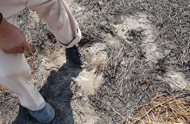
Sott Spanish recently reported that there is a place in Mexico called Chalco, which is more or less half the way between the Popocatépetl volcano and Mexico City (50 km from the volcano), where the earth is burning. Mexican scientists are researching the area and locals fear that it is related to Popocatépetl and/or that a new volcano is going to appear on the spot.


Sott Spanish recently reported that there is a place in Mexico called Chalco, which is more or less half the way between the Popocatépetl volcano and Mexico City (50 km from the volcano), where the earth is burning. Mexican scientists are researching the area and locals fear that it is related to Popocatépetl and/or that a new volcano is going to appear on the spot.

Translated from Spanish by Microsoft
I inform you that yesterday with the support of Federal Police, staff CENAPRED and UNAM conducted a reconnaissance overflight of the volcano Popocatepetl, in order to know the current state of the internal crater and determine the changes produced in this

Second Tweet
Translated from Spanish by Microsoft
It could be seen that it has not formed dome and the Inner crater maintains the same dimensions of about 350 m in diameter and 250 of depth.

Translated from Indonesian by Microsoft
A thick enough ash rain crashed around Mount Sinabung. Dark sky covered in volcanic ash after eruption Mount Sinabung with a high ash of 2 km at 7/5/2019 at 07.48 WIB. The eruption was recorded in the seismogram of the maximum amplitude of 120 mm and a duration of ± 42 min 49 sec. (Foto Ricky).


Meanwhile: Video
May 9 at 4:27am
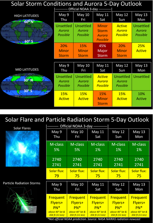
Direct Hit After a Long Wait: Solar Storm Forecast 05-09-2019
Our Sun kicks things into high gear with two monster bright regions rotate into Earth view. They have been rapid firing solar storms and solar flares over the past week and finally one has been launched in the Earth-strike zone! According to models the storm will arrive on May 11.
8576d6efc65d758b2e4c4819ad49113c.png
 

Translated from Spanish by Microsoft
NEVADOS DE CHILLÁN | During the present day (10/05), the Volcanic Observatory of the Southern Andes (OVDAS) has reported three new explosions in the Nicanor dome of the volcanic complex #NevadosdeChillán. 🌋👇
In the video, courtesy of OVDAS, you can see an explosion with eruptive column development, accompanied by a small current of pyroclastic density that descends through the slopes. 👇

Translated from Spanish by Microsoft
🌋🇲🇽 Yesterday at 12:34 hrs was recorded a small explosion with low ash content in the volcano of Colima. First manifestation of the increase reported in past days. Keep an eye on the official information and respect the 8 km exclusion zone.

Translated from Spanish by Microsoft
IMPORTANT-🇪🇨🌋 detected a moderate anomaly in the Sangha volcano located in #Ecuador This indicates the possible rise of magma to the crater of the volcano. This activity could be the beginning of a new eruptive phase.

Translated from Spanish by Microsoft
RSN-ICE surveillance cameras captured a small groundwater eruption in Rincón de La Vieja volcano. It is recommended that the population stay away from the channels around the volcano due to the possibility of generation of lahars. Edition: Dr. Paulo Ruiz.
 
Translated from Spanish by Microsoft
🌋🇲🇽 Yesterday at 12:34 hrs was recorded a small explosion with low ash content in the volcano of Colima. First manifestation of the increase reported in past days. Keep an eye on the official information and respect the 8 km exclusion zone.
Was not able to see the twitt, it seems Colima's volcano is starting again.

#ColimaVolcano Today at 12:34 pm there was a small explosion with low ash content. First manifestation of the increase reported in past days. Stay tuned for official information.

At midday this Saturday after a couple of weeks of announcing the increased activity of #Volcano #Colima and one day after the collapse of part of the crater, today shows an explosion with low content of #Ceniza. Time: 12:35 local time

using deepl traductor
 
Was not able to see the twitt, it seems Colima's volcano is starting again.
Translated from Spanish by Microsoft
🇲🇽🗻 The internal activity of the volcano of fire in Colima remains frequent however the external activity does not show a significant change only a small explosion that occurred on May 11. 🔶 It is possible that in the coming days or weeks we'll see some explosions.


Translated from Spanish by Microsoft
⚠️ Now: An explosion is recorded in the volcanic complex #NevadosDeChillán, located in the region of the #Ñuble, in #Chile. The activity is framed in the parameters of its alert level, therefore it remains technical alert in ORANGE


I supposed it is another effect of the same general thing mentioned here, could it be a volcano or something else? as an effect from the sinkhole or they are just interpreting .. Session 1 December 2018

Newly forming underwater volcano discovered near Mayotte, source of intense earthquake swarm
Attempts to understand the reason behind the intense volcano-seismic crisis affecting Mayotte since May 2018 have finally resulted in a solid answer - the discovery of newly forming underwater volcano.

The volcano is located 50 km (31 miles) east of the Petite-Terre island at a depth of 3 500 m (11 482 feet), BGRM, the France-based geological agency serving the territory said.

The current size of the volcano is estimated at 800 m (2 624 feet), with a base 4 to 5 km (2.5 - 3.1 miles) in diameter.

Volcanic fluids have been detected at a height of about 2 km (1.2 miles) above the volcano.

The gas emanations reported along the Petite-Terre coastline are a common sign encountered in this type of volcanic activity and will be the subject of specific studies.

new-submarine-volcano-near-mayotte-discovered-may-2019.jpg

Image credit: MAYOBS

The discovery provides a better understanding of intense earthquake swarm shaking the region since May 2018, BRGM said, adding that the government and the scientific community is fully mobilized to continue analyzing this exceptional geological phenomenon.

Authorities said their next order of business is to evaluate seismic, volcanic and tsunami risks and place appropriate anticipation measures.

This region is experiencing intense earthquake swarm since May 2018.
The swarm started at 05:14 UTC on May 10, 2018 and increased around 12:00 UTC with magnitudes close to 3.0. Magnitudes further increased to 3.5 and 3.7 by 16:40 UTC.
The first quake felt by the population was M4.5 at 23:19 UTC on May 10, according to the BRGM.
This abnormal earthquake swarm continued for the next two months, creating anxiety and stress among locals and forcing authorities to open up a psychological support unit on June 12.
While there have been no serious injuries or fatalities, locals reported minor damage to buildings, including a school in Dembeni. In addition, at least 10 families have been evacuated from damaged homes and temporarily relocated.

Mayotte’s firefighters are conducting drills designed to simulate rescuing people trapped by a landslide, and emergency experts are teaching island residents to check their homes and businesses for cracked walls or other signs of stress, Africa Times reported June 30, 2018.
One resident told the paper he left his home because of meters-long cracks in the walls, along with his 80-year-old mother who had become agitated by the hundreds and hundreds of quakes that are strong enough to be felt. Many people slept in the streets when the swarm began, unsure if the shaking would become worse and potentially collapse their homes and trap them inside.
Others began to have anxiety attacks, with each quake followed by dozens of calls to Mayotte’s regional health authorities.

The head of Pamandzi College said in a television interview that some teachers are on sick leave because they do not sleep at night. Other teachers do not plan to return to Mayotte after the school holidays if the seismic activity continues, he said.
seismes_mayotte_mai_2018_07.jpg

Image credit: BRGM
An atypical very low frequency signal originating near the island of Mayotte was detected by international networks around the world just before 09:30 UTC on November 11, 2018. The signal repeated in a wave about every 17 seconds, lasting for about 20 minutes in total. Signals of this type are characteristic of volcanic phenomena, BRGM scientists say.

"The appearance of this earthquake swarm in May 2018 took scientists by surprise. Geological knowledge of the swarm zone is limited, but a clearer understanding of the phenomenon is emerging as observations continue. Different hypotheses as to their causes have been investigated."

In addition to the seismic measurements used to track how this swarm is evolving, new data were analyzed in October and November 2018, especially those on the deformation of the island's surface (GPS measurements by the IGN). The team working at the Geology Laboratory of the Ecole Normale Supérieure in Paris has shown that the current phase in the swarm is accounted for by a volcanic component.
seismo-volcanic-crisis-mayotte-indian-ocean.jpg

Image credit: ENS

Since mid-July [to November 2018], GPS stations on the island have tracked it sliding more than 61 mm (2.4 inches) to the east and 30 mm (1.2 inches) to the south, according to data provided by the Institut National de L’information Géographique et Forestière.
Using these measurements, Pierre Briole of the Ecole Normale Supérieure in Paris estimated that a magma body that measures about 1.4 km3 (0.3 mi3) is squishing its way through the subsurface near Mayotte.
The last known volcanic eruption in this area took place in 2050 BCE ± 500 years.

Geological background
Mayotte Island in the Mozambique Channel between the northern tip of Madagascar and the eastern coast of Africa consists of two volcanoes with diverse geochemistry that were active from the Pliocene to the Holocene.
Lavas on the NE were active from about 4.7 to 1.4 million years and on the south from about 7.7 to 2.7 million years.
Mafic activity resumed on the north from about 2.9 to 1.2 million years and on the south from about 2 to 1.5 million years. Morphologically youthful-looking maars are present on Mayotte Island, and Zinke et al. (2003) found several pumice layers of Holocene age in gravity cores on the barrier reef-lagoon complex at Mayotte. (GVP)

Featured image: Location of newly forming submarine volcano near Mayotte. Credit: MAYOBS
edit, add words
 
Last edited:
22-23 May, eruption Fuego's volcano, Guatemala
https://conred.gob.gt/site/Boletin-Informativo-1602019 said:
Newsletter No. 1602019
Friday, 24 May 2019
MONITORING IS MAINTAINED OVER THE VOLCANOES OF FUEGO, PACAYA AND SANTIAGO.

The monitoring of the country's volcanic activity is constantly maintained by the Volcano Prevention Unit of the Executive Secretariat of CONRED and through the volcanological bulletins issued daily by the National Institute of Seismology, Volcanology, Meteorology and Hydrology -INSIVUMEH-.

Currently the Fuego volcano keeps its sector partially clear, has generated between 19 to 21 weak and moderate explosions every hour, expelling columns of ash at 4,800 meters above sea level dispersing towards the west and southwest of the volcanic cone. At night and early morning, incandescent material has been observed that rises up to 300 meters above the crater generating weak and moderate avalanches, ash fall in nearby communities and possible laharic activity is monitored during the afternoon and night.

The Pacaya volcano maintains its partially cloudy sector, has generated abundant degasification that disperses towards the South at low altitude, has registered internal tremor (vibration) associated with the ascent of magma to the surface, maintains strombolian type explosions and during the night a lava flow has been observed that reaches 300 meters in length towards the North of the volcanic cone.

In the zone of the Santiaguito volcano the environment is kept clear, generating columns of ash and degassing that reach 3 thousand 100 meters above sea level dispersing towards the West and Southwest and during the last 24 hours there have been weak explosions that generate avalanches in the East and South East of the volcanic cone.

For now, Fuego, Pacaya and Santiaguito volcanoes maintain their activity within average levels, according to our scientific entity INSIVUMEH. However, there is constant monitoring for any increase that could be registered in any of these volcanoes.

Translated with www.DeepL.com/Translator
Average levels ??? ... the Ring of Fire is very active nowadays, and they say it as if the matter were very normal, of course everything can be worse ...
 
Me and my big mouth/thought, I wrote above "everything can be worse" and before I shut down internet and computer, I find this news:

Strong eruption at Agung volcano, several flights canceled - Bali, Indonesia
Posted by Teo Blašković on May 24, 2019 at 20:56 UTC (1 hour ago)
Category: Volcanoes
Strong eruption at Agung volcano, several flights canceled - Bali, Indonesia


The eruption took place at 11:23 UTC (19:23 WITA) and lasted for 4 minutes and 30 seconds.
The Darwin VAAC said volcanic ash was observed on multispectral satellite imagery up to 4.5 km (15 000 feet) a.s.l. Distinguishable hot spot and incandescent lava flow were observed on webcam imagery 3 km (1.8 miles) from the crater.
A thin layer of ash covered nearby villages. Several flights to and from Bali international airport have been canceled.


"Thundering sounds from the eruption were heard adequately strong from the monitoring post," Indonesia's Center of Volcanology and Geological Disaster Mitigation (PVMBG) said.

Residents and tourists are strictly prohibited to enter danger zone 4 km (2.5 miles) around the crater.

Residents living around nearby rivers are advised to remain vigilant on the possible stream of hot lava or volcanic materials.

https://youtu.be/i2BINzE4t-Q
 
Indonesian officials warned on Monday against the prospect of further eruptions from an active volcano on the island of Sumatra after it emitted a huge column of ash, causing panic among residents.

Indonesia warns of further eruptions after volcano spews ash
A volcanic ash cloud from Mount Sinabung hovers over Karo, North Sumatra, Indonesia June 9, 2019, in this still image taken from a social media video. Sinarisa Sitepu via REUTERS

Mount Sinabung, which has seen a spike of activity since 2010, erupted for around 9 minutes on Sunday, sending clouds of volcanic ash 7 km (4.4 miles) into the sky.

“After the eruption, from midnight until 6 a.m., there were a few aftershocks,” said Willy, a scientist at a Sinabung observatory post, who uses one name, like many Indonesians.

Authorities left unchanged the alert level for Sinabung, but urged residents to use face masks and keep indoors to guard against volcanic ashfall.

Mount Sinabung, which is 2,460 m (8,071 ft) high, is among Indonesia’s most active volcanoes, but had been inactive for four centuries before its 2010 eruption. Indonesia has nearly 130 active volcanoes, more than any other country.


Translated from French by Microsoft
If you live in the North of the country (North of the Seine), Astronomical twilight lasts all night at the moment and a blue fringe remains on the Northern horizon. You can cross clouds #noctulescents(#NLC) This night at 0h11 #Lestren(62) Sylvain wallart-reggane


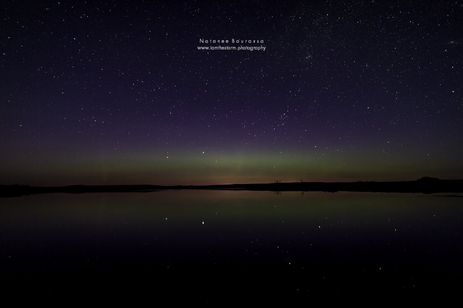
[B]Notanee Bourassa[/B]‏ @[B]DJHardwired[/B] Jun 9
@TamithaSkov @TweetAurora The #aurora was visible in a soft diffuse band with just a hint of unsettledness at 1:30am CST9JUN2019 as captured 95km north of #Regina #Saskatchewan
D8q65_IXoAAaotG.jpg:large


13 June, eruption of Sakurajima volcano, Kyūshū Island (in fact had been in activity since 2018 according to reports from below --in japanese, it is understandable with google traductor

Note: 06月(June)13(day)日 09(hr)時21分(minutes)、噴火 (eruption) 連続噴火継続 (continue eruption)
-https://373news.com/_sakurajima/funka/ said:
30481
video from 13 June

https://youtu.be/oiBGMgHbvOI
Add: Red Climática Mundial
 
Last edited:
Back
Top Bottom