Volcanoes Erupting All Over

Indonesian volcano erupts near third-biggest city
JAKARTA July 26, 2019 - A volcano erupted near Indonesia’s third-biggest city of Bandung on Friday, sending ash several hundred meters into the air and triggering warnings for people to stay away.

Broadcasters showed footage of cars and motorbikes driving away from Tangkuban Parahu on roads covered by ash. The disaster mitigation agency said the tourism spot had been closed and the alert status of the volcano was being evaluated.

The volcano is about 30 km (18 miles) north of Bandung, the capital of West Java province.

Indonesia is on the so-called Pacific Ring of Fire and has scores of active volcanoes, sometimes posing a threat to life and disrupting air travel, particularly on the most heavily populated islands like Java and Bali.
 
Together with #CENAPRED of @CNPC_MX, during a reconnaissance flight carried out with the support of #GuardiaNacional, we corroborated the destruction of dome number 83 of volcano #Popocatepetl. #YourSecurityOurMission ---using deepl.com

Hope goverment is already prepared for evacuating people for the very possible pyroclastic flows that comes after destruction of the dome.
 
https://watchers.news/2019/08/06/six-underwater-volcanoes-discovered-near-sicily-mediterranean-sea/ said:
Six underwater volcanoes discovered near Sicily, Mediterranean Sea

Six underwater volcanoes discovered near Sicily, Mediterranean Sea


Scientists have discovered a series of previously unknown volcanoes just off the coast of SW Sicily, Italy. The three northern volcanoes show a tuff cone-like morphology while the three most southern edifices have a truncated-conical shape. Ages of all newly discovered volcanoes are Late Quaternary. Only the northernmost volcano shows indications of a post-Last Glacial Maximum magmatic reactivation.

The Graham and Terrible banks, located about 35 km (21 miles) from the south-western coast of Sicily, host a large number of volcanic constructs, the most famous being the ephemeral Ferdinandea Island, authors said in the abstract of the new study, published recently in Elsevier's Marine Geology.

These volcanoes occur along two N-S trending strike-slip lineaments that constitute the lithospheric-scale Capo Granitola-Sciacca Fault Zone.

In the study, the researches presented recently acquired swath bathymetric data and magnetic measurements, in conjunction with high-resolution seismic profiles, which reveal the presence of another six volcanic edifices located very close to the Sicilian coasts, one of which is only 7 km (4.3 miles) away.

3 of these volcanic constructs have been previously identified only on the basis of available seismic profiles, but their morphology and their volcanic nature had so far not been documented. 2 edifices to the north show a possible tuff cone/ring-like morphology modified by crater breaching, while the three southernmost volcanoes have a truncated-conical shape.

The northwestern-most volcano (here called Actea) shows a more complex morphology, probably representing the remnants of a previous crater rim.

Seismic data analysis suggests that the six volcanic edifices were generated during a pre-Last Glacial Maximum (ca. 20 000 B.P.) magmatic phase associated with a tectonic event.

Only the Actea volcano shows indications of magmatic reactivation, possibly between the LGM and the initial post-LGM transgressive phase. This reactivation is evident by the emplacement of a prominent young lava flow.

The discovery of submerged volcanoes so close to the populated coast of Sicily demonstrates that there are large submerged areas near the littoral that are still little known and studied, and underlines how crucial it is to analyze the issue of volcanic risk for densely inhabited coastal areas like Sicily.

Reference:
"A series of volcanic edifices discovered a few kilometers off the coast of SW Sicily" - Emanuele Lodolo, Dario Civile, Massimo Zecchin, Luigi Sante Zampa, Flavio Accaino - Redirecting
 
8 August, Nevados de Chillan, Chile
NEVADOS DE CHILLAN!! This morning there was an explosive event associated with the fluid dynamics inside the volcanic system. Technical alert is maintained at #Naranja and recommendation is to be informed through official channels @onemichile @Carabdechile @Sernageomin --using deepl.com

NEVADOS DE CHILLÁN!! During today, different pulses have been recorded that have been observed by the community. These events are expected for the current technical alert level maintained at #Naranja. Remember to stay informed by @onemichile @Carabdechile --using deepl.com

7 August, Villarica Volcano, Chile
VILLARRICA VOLCANO! Yesterday we changed the technical alert to Amarilla for several reasons. Overflight images and technical analysis confirmed the emission of pyroclasts at 200 mts from the crater, with a speed of the order of 100 km/hora. It is important to respect an affected area of 500 meters. --using deepl.com

 
Here's an interesting item:


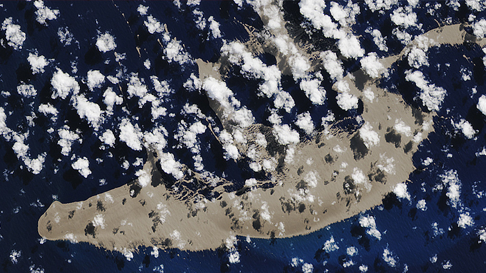
A gigantic floating rock formation, believed to emanate from the depths of the Pacific Ocean, is heading directly for Australia, and some believe it may prove to be a lifeline for the Great Barrier Reef.

The giant volcanic rock pumice, over 20,000 football fields in size, is believed to be the result of an underwater eruption from deep in the heart of the Pacific Ocean, off the coast of Tonga.

The formation is so large it has been spotted on satellite imagery, while several sailors have posted remarkable footage of the unusual new floating island.

“We sailed through a pumice field for 6–8 hours, much of the time there was no visible water,” sailor Shannon Lenz wrote on YouTube.

<iframe width="560" height="315" src="
" frameborder="0" allow="accelerometer; autoplay; encrypted-media; gyroscope; picture-in-picture" allowfullscreen></iframe>
 
“We sailed through a pumice field for 6–8 hours, much of the time there was no visible water,” sailor Shannon Lenz wrote on YouTube.
They probably had to go slow, pumice is abrasive; if there had been big waves how would they have avoided that it ended up on the deck?
About pumice there is: Pumice - Wikipedia and it turns out a floating pumice field is called a pumice raft

Pumice varies in density according to the thickness of the solid material between the bubbles; many samples float in water. After the explosion of Krakatoa, rafts of pumice drifted through the Indian Ocean for up to 20 years, with tree trunks floating among them.[6] In fact, pumice rafts disperse and support several marine species.[7] In 1979, 1984 and 2006, underwater volcanic eruptions near Tonga created large pumice rafts, some as large as 30 kilometers (19 mi)[citation needed] that floated hundreds of kilometres to Fiji.[8]

31475

The next two volcanoes are near Tonga Island:
Home Reef - Wikipedia Mentions a vulcano that produced a pumice raft in 2006
Curacoa volcano - Wikipedia Mentions a vulcano that produced pumice rafts in 1973 and 1979
The giant volcanic rock pumice, over 20,000 football fields in size, is believed to be the result of an underwater eruption from deep in the heart of the Pacific Ocean, off the coast of Tonga.
20,000 football fields if it is soccer size (50m x100m) would mean 10,000 ha or 100 km^2
2012 Kermadec Islands eruption - Wikipedia Describes an underwater vulcano near New Zealand that produced a pumice raft covering 400 km^2
 
WHY ARE SUNSETS TURNING PURPLE? Every year, on average, about 60 volcanoes erupt somewhere on Earth, shooting ashy plumes of sulfurous gas thousands of feet into the air. Rarely do those plumes make it all the way up to the stratosphere. This summer, however, two volcanoes have done it. The Raikoke volcano in the Kirul Islands (June 22nd) and the Ulawun volcano in New Guinea (Aug. 3rd) both punched through to the stratosphere, sending material as high as 60,000 ft.

The action of these two volcanoes may explain why many sky watchers are starting to notice purple sunsets.
[...]
 
Back
Top Bottom