1990 Oregon Crop Circle 13.3 miles in size

Rabelais

Dagobah Resident
FOTCM Member
Just saw this posted on my facebook feed. An Oregon circle in a hard dry lake bed. Its huge and the biggest I have seen. It was photographed by Air Force reserve pilots at 9000 feet. Was this before the 3D technology for circle creation? Might be a good whodunit question for the Cs.

https://www.youtube.com/watch?feature=player_embedded&v=KliBRinZHJA#!
 
WOW!
I wasn't aware that the 'crop' cricles are still being made the way Nazca lines are, as in not in crops but in hard land..
 
Well, It certainly wasn't made by a couple of guys with planks who sneaked in at night! This is one that would be pretty much impossible to explain by human origin.
 
These are the ones I like :lol:

The general 'prankster' approach to crop circles is one of the most ridiculous dismissal strategies that can be adopted by beings with any amount of firing neurons in their heads.IMO
 
Thought I'd bring up this topic because it's not on the forum and also because the English CC's this year (like last) are so abysmal they must be man-made!

Anyway, I hadn't heard about this mandala image that was cut into the dry earth in 1990 in the middle of nowhere in Oregon. Location is meant to be somewhere near "Mickey basin" in Oregon, although I can't see any evidence of the mandala on google maps today.

http://www.iccra.org/bystate/Oregon/ICCRA%20-%20OR%20-%20Steens%20Mountain-Mickey%20Basin-Alvord%20Desert,%20Harney%20County%20%28September%2010,%201990%29.htm

Reported Crop Circles for the State of Oregon -

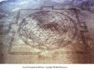
Steens Mountain / Mickey Basin / Alvord Desert, Harney County
(September 10, 1990)

A very large, perfectly formed, ancient Hindu mandala called the Sri Yantra was discovered inscribed into the dry lakebed by an Air National Guard pilot on a normal training run from a base near Boise, Idaho. This symbol was over a quarter of a mile in length, and consisted of over 13 miles of lines etched into the impacted mud 3”-10” deep. No human or tire tracks found anywhere near the site. A group of 5 artists from Iowa tried claiming responsibility for the symbol's appearance saying they carved the entire design with a garden cultivator during a nine-day period. No other pilots or anyone else reported seeing it in any stage of their supposed construction time. Analysis of the formation’s line indicated that the soil had been removed, whereas the artists’ garden cultivator / plow method produced small mounds of dirt on either side of their demonstration lines left from where they plowed.

More here

http://cropcircleconnector.com/ilyes/ilyes9.html

I'm pretty surprised at how little info there is on the web about this, especially since it's been around for more than 20 years.
 

Attachments

  • oregon-mandala.jpg
    oregon-mandala.jpg
    21.7 KB · Views: 145
Thanks for bringing it up. I did also a minor search on the web some weeks ago and tried to get some info and at least tried to find it on google maps. And I came to the same conclusion that there is almost no information about available and was also not lucky to get the coordinates. The coordinates I got didn't show this mandala either. But it could be due to erosion, sand moving that it is not viewable, beside google maps was launched in 2005. But the same could be asked the about the Nazca Lines.
 
Gawan said:
Thanks for bringing it up. I did also a minor search on the web some weeks ago and tried to get some info and at least tried to find it on google maps. And I came to the same conclusion that there is almost no information about available and was also not lucky to get the coordinates. The coordinates I got didn't show this mandala either. But it could be due to erosion, sand moving that it is not viewable, beside google maps was launched in 2005. But the same could be asked the about the Nazca Lines.

Yeah, I think if this were real, it would still show up on google earth - or at least some faint trace of it would. It's so easy to photoshop stuff like this that it would be nice to get some sort of satellite image to corroborate it.
 
There's another thread about this crop circle-like thing here:

http://cassiopaea.org/forum/index.php/topic,31601.msg421825.html
 
ametist said:
These are the ones I like :lol:

The general 'prankster' approach to crop circles is one of the most ridiculous dismissal strategies that can be adopted by beings with any amount of firing neurons in their heads.IMO

Couldn't agree more.
 
Laura said:
What are the coordinates so we can view it on google earth?

I don't know about the coordinates, but it is mentioned in this article:

_http://lucas2012infos.wordpress.com/2012/06/06/steve-beckow-1990-oregon-crop-circle-a-sri-yantra-included-video-6-june-2012/

That it was located in the Mickey Basin, Oregon.

And, the person who uploaded the video said that area was "filled in by flooding over the years."
 
Rabelais said:
Just saw this posted on my facebook feed. An Oregon circle in a hard dry lake bed. Its huge and the biggest I have seen. It was photographed by Air Force reserve pilots at 9000 feet. Was this before the 3D technology for circle creation? Might be a good whodunit question for the Cs.

https://www.youtube.com/watch?feature=player_embedded&v=KliBRinZHJA#!

the guy who posted the video also says this in the comments section.

Sorry but this has been filled in by flooding over the years...It only lasted for a short while before the lines started getting filled up with dirt from floods...I have a new video of one in Australia on my channel you might want to check out that video because it is bigger...
 
In short, with no real evidence but what could be photoshopped images, it's little more than a claim.
 
Laura said:
In short, with no real evidence but what could be photoshopped images, it's little more than a claim.

Well it's allegedly the subject of a report in UFO Magazine, volume 6 #3, 1991 (A Symbol on the Oregon Desert) by a Dr. Deardorff. I'll see if I can get any confirmation on it.
 
There's a 1997 article in the crop circle connector on this

http://cropcircleconnector.com/ilyes/ilyes9.html

As you may know, Eastern Oregon was Gifted with the Sri Yantra Mandala Formation in August 1990. It arrived in a dry wilderness lake bed east of Steens Mountain, and consisted of 13.3 MILES of lines, each 10" wide and scored to a depth of 3 inches in the hardpan. The graphic below is the Sri Yantra, and the Pattern discovered in the dry earth was identical in all respects.

Four jokers claimed it - the joke was that they alleged they pulled a 'garden cultivator' like a plow for OVER 13 MILES, in an officially designated Wilderness Area, in the August desert heat - where not even cars are permitted. They concocted the story that they hauled all their gear 3/4-mile to the site each day.


Apparently it's not visible on Google Earth: _http://productforums.google.com/forum/#!msg/gec-earth-browsing/qnSB5HoBqvE/fem5s9NjIbcJ
Unfortunately the Pictogram has been erased by the weather in the time passed since 1990, but this is where is was when it was still visible.


[/quote]
 
Back
Top Bottom