Ancient Human Metropolis Found in South Africa

Erna

The Living Force
I found something very interesting online today. I'm just going to supply the link here, instead of copying the whole lot in here.

http://www.viewzone.com/adamscalendar.html

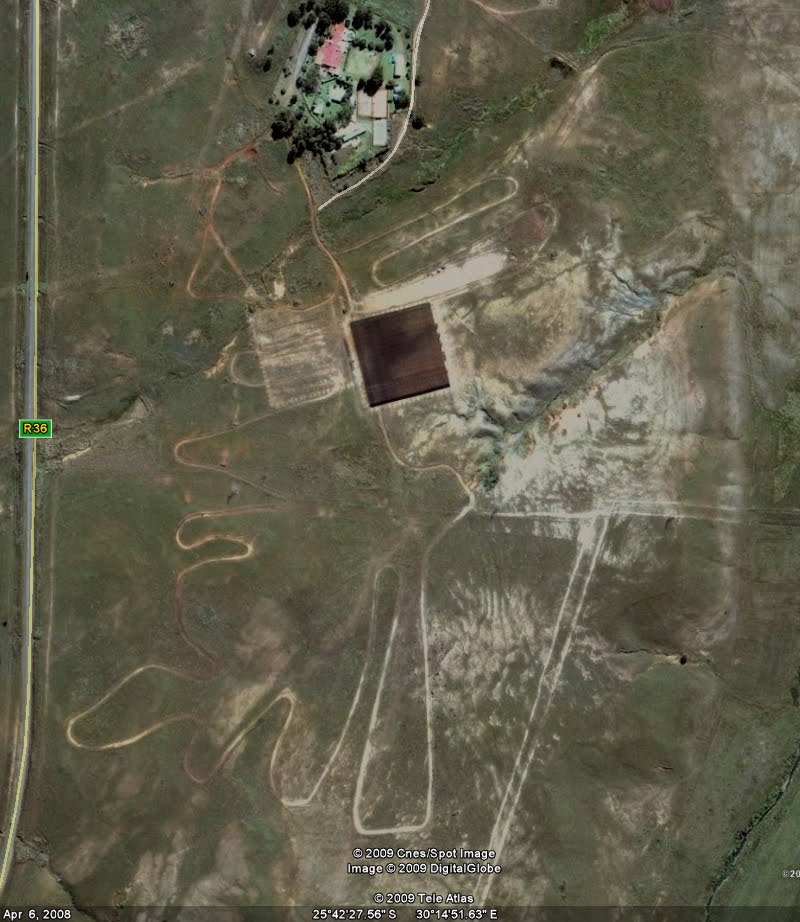
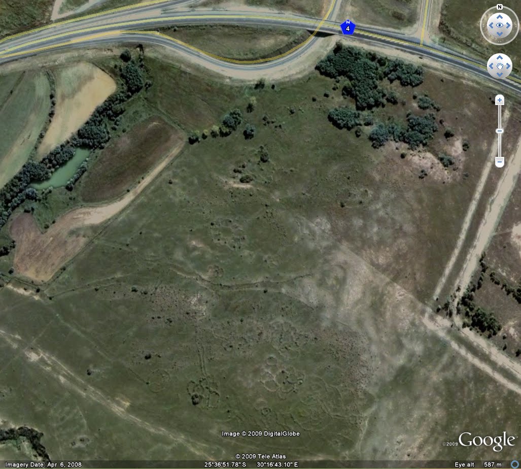
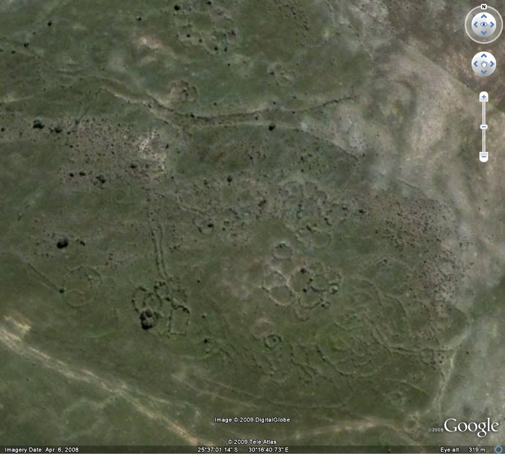
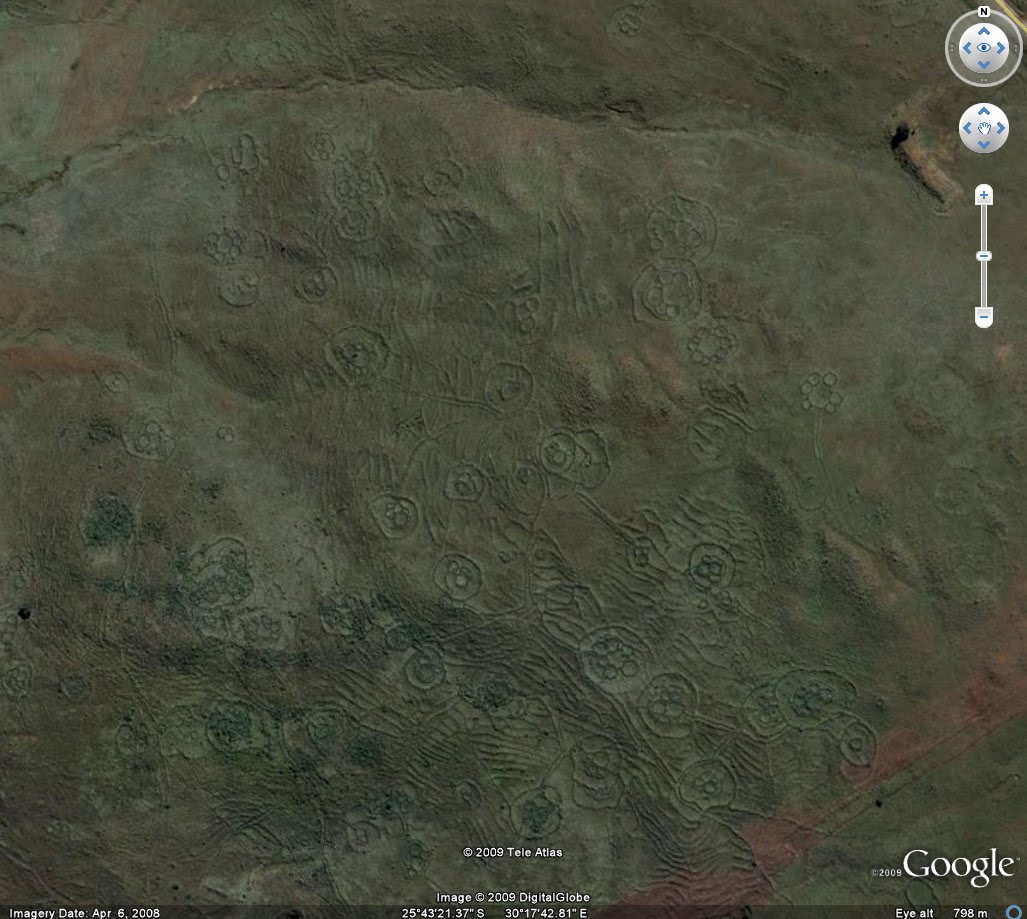
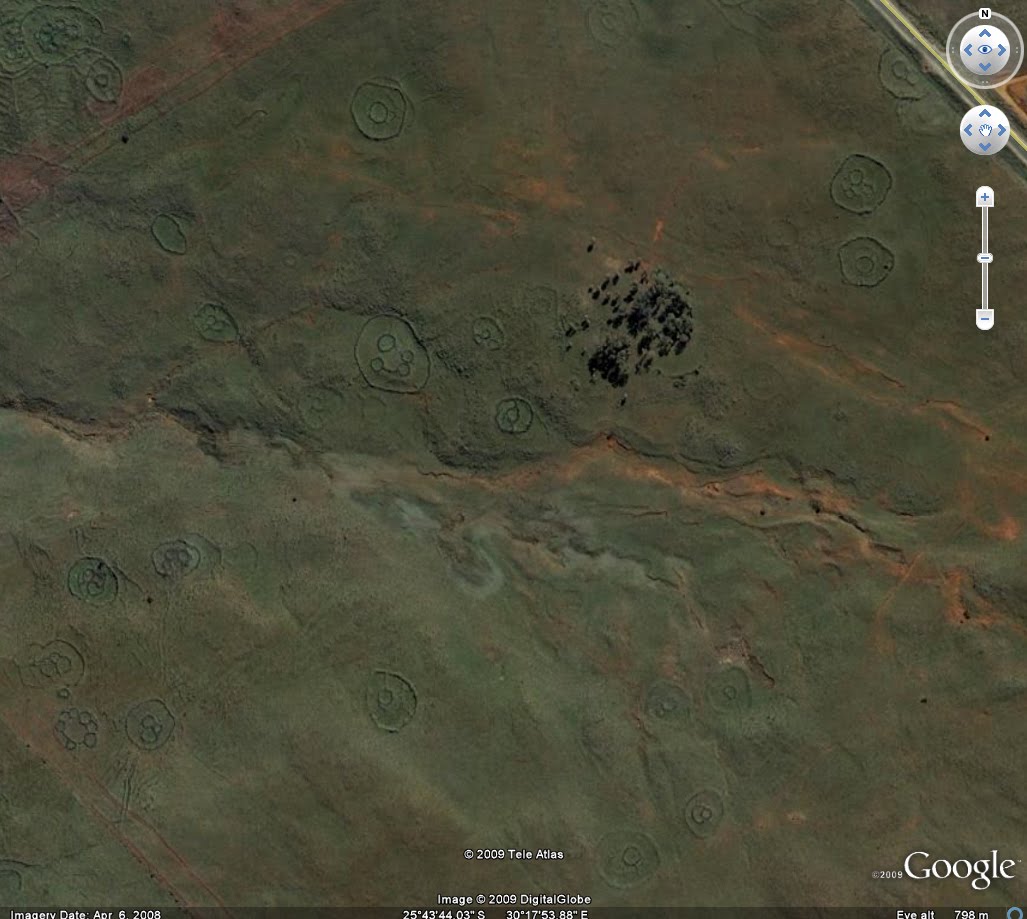
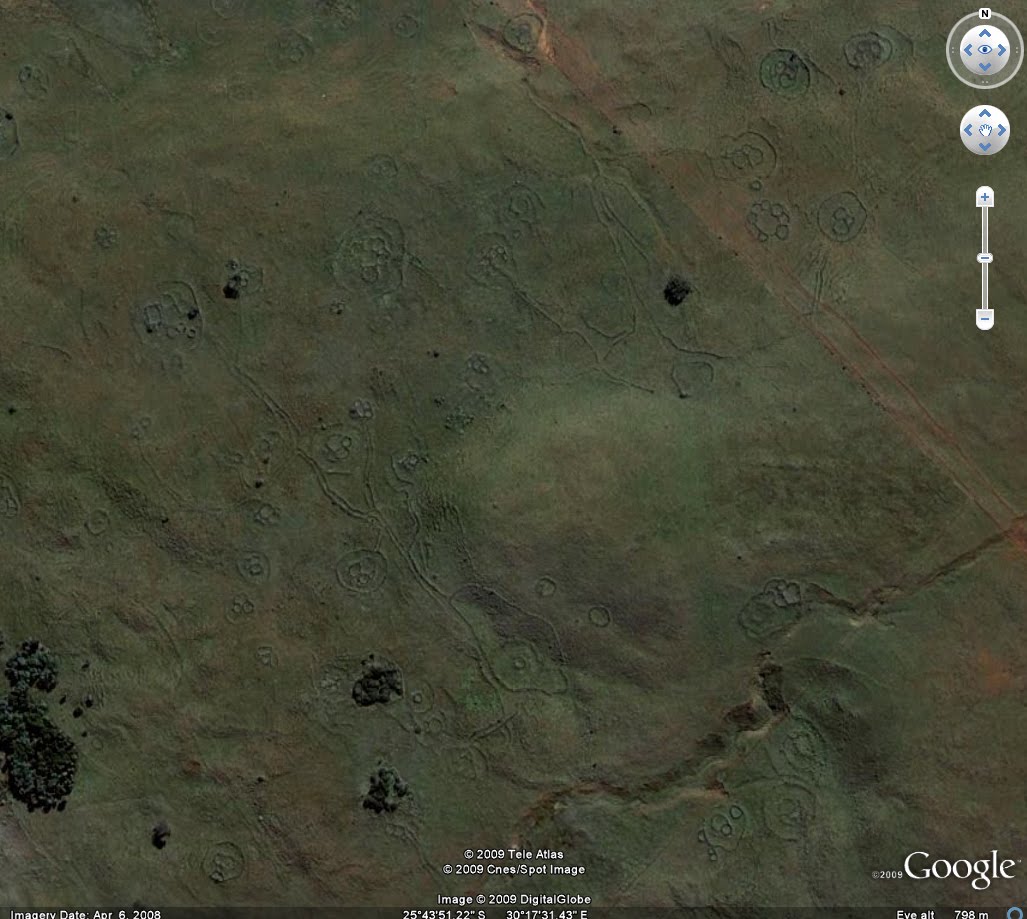
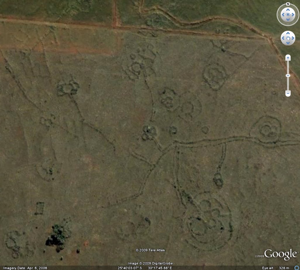
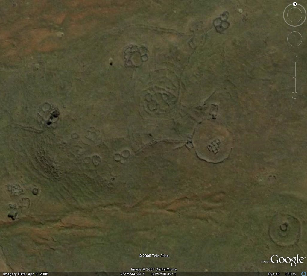
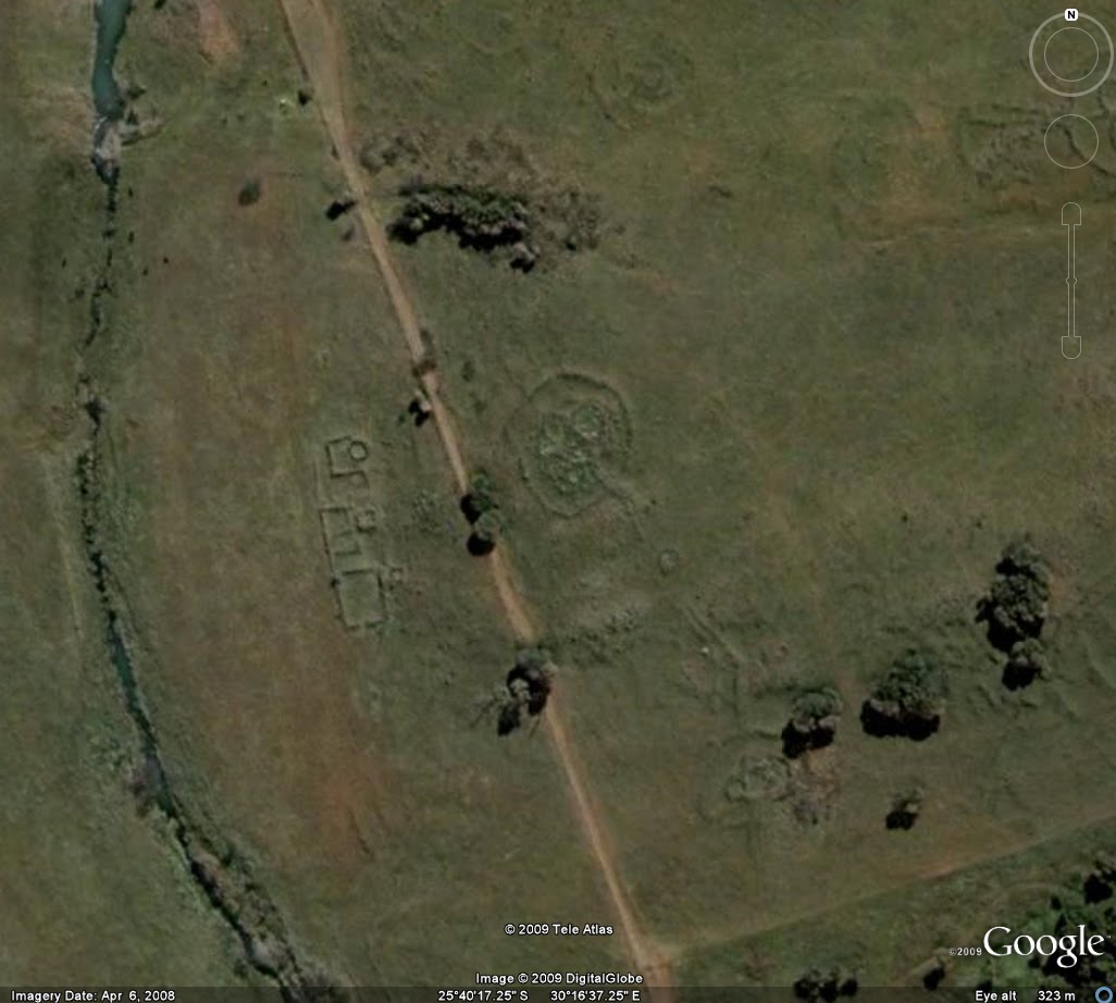
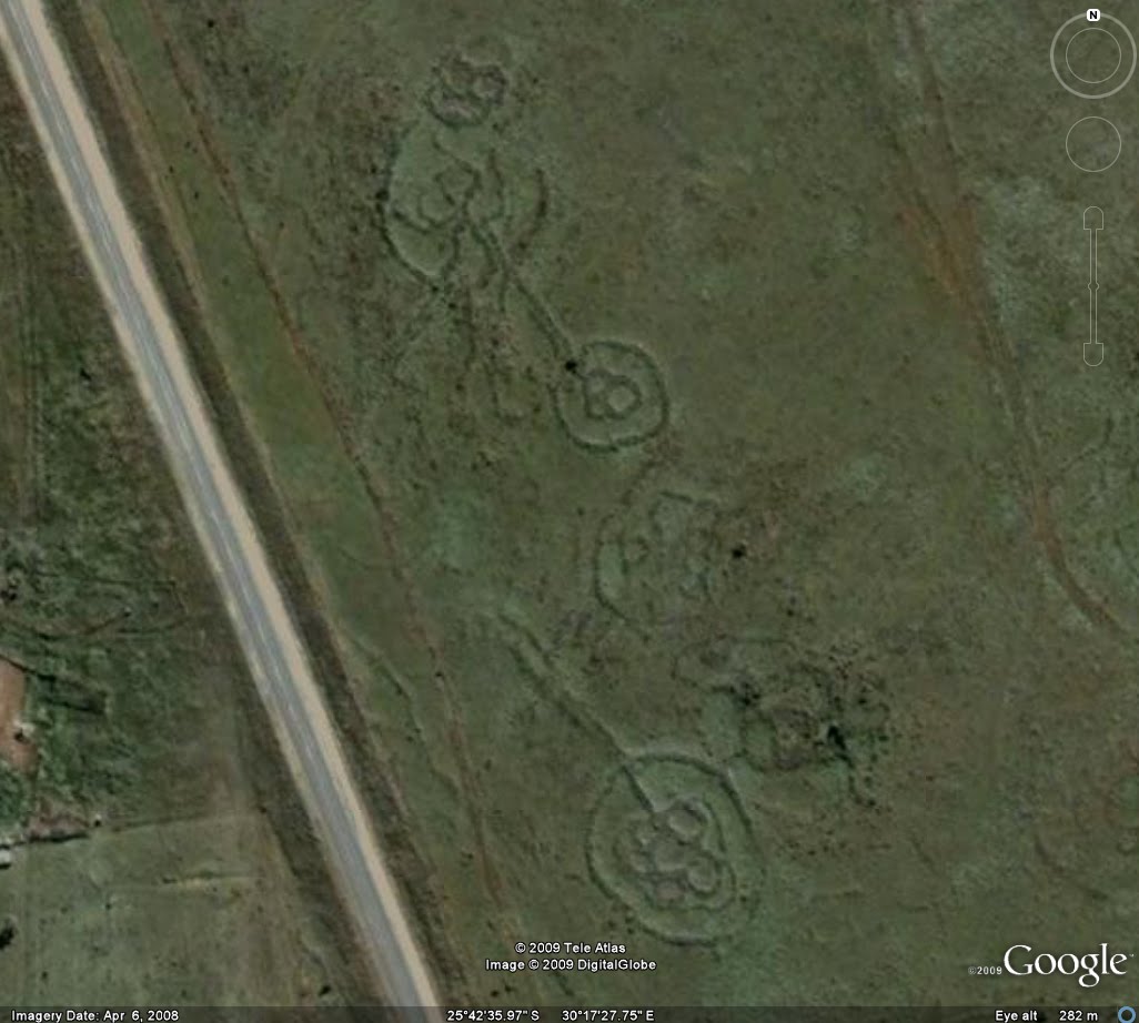
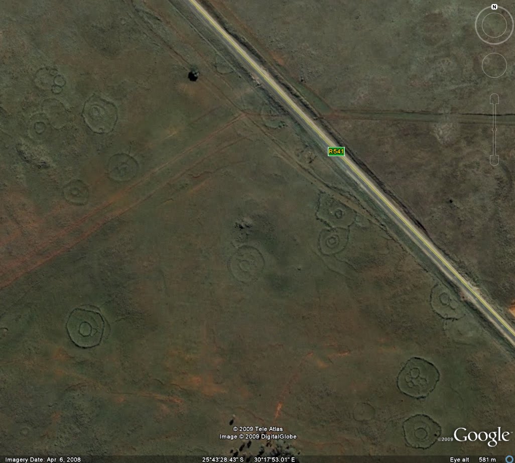
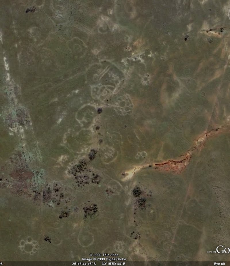
I went to Google Earth and took a screen capture. The area is really big. If you go to Machadodorp on Google Earth (type it into the area field) and then just move South to Emthonjeni, and then just slightly SSE from Emthonjeni, you'll find it. It's quite astonishing that they estimate these ruins at 160,000 to 200,000 BCE.

googleEarth.jpg


A short excerpt from the site:

adams22.top.jpg


Dating the site:

Finding the remains of a large community, with as many as 200,000 people living and working together, was a major discovery in itself. But dating the site was a problem. The heavy patina on the rock walls suggested the structures were extremely old, but the science of dating patina is just being developed and is still controversial. Carbon-14 dating of such things as burnt wood introduces the possibility that the specimens could be from recent grass fires which are common in the area.
The breakthrough came quite unexpectedly. As Tellinger describes it:

adams22.manstone.jpg


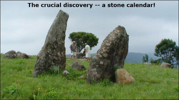
"Johan Heine discovered Adam's Calendar in 2003, quite by accident. He was on route to find one of his pilots who crashed his plane on the edge of the cliff. Next to the crash site Johan noticed a very strange arrangement of large stones sticking out of the ground. While rescuing the injured pilot from about 20 metres down the side of the cliff, Johan walked over to the monoliths and immediately realised that they were aligned to the cardinal points of Earth -- north, south, east and west. There were at least 3 monoliths aligned towards the sunrise, but on the west side of the aligned monoliths there was a mysterious hole in the ground -- something was missing.
After weeks and months of measuring and observations, Johan concluded that it was perfectly aligned with the rise and fall of the Sun. He determined the solstices and the equinoxes. But the mysterious hole in the ground remained a big puzzle. One day, while contemplating the reason for the hole, the local horse trail expert, Christo, came riding by. He quickly explained to Johan that there was a strange shaped stone which had been removed from the spot some time ago. Apparently it stood somewhere near the entrance to the nature reserve.

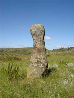
After an extensive search, Johan found the anthropomorphic (humanoid shape) stone. It was intact and proudly placed with a plaque stuck to it. It had been used by the Blue Swallow foundation to commemorate the opening of the Blue Swallow reserve in 1994. The irony is that it was removed from the most important ancient site found to date and mysteriously returned to the reserve -- for slightly different reasons.

adams22.still.gif


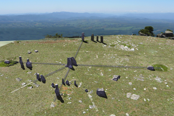
The exact location of the calendar is listed on http://www.makomati.com/. The first calculations of the age of the calendar were made based on the rise of Orion, a constellation known for its three bright stars forming the "belt" of the mythical hunter.
The Earth wobbles on its axis and so the stars and constellations change their angle of presentation in the night sky on a cyclical basis. This rotation, called the precession completes a cycle about every 26,000 years. By determining when the three stars of Orion's belt were positioned flat (horizontal) against the horizon, we can estimate the time when the three stones in the calendar were in alignment with these conspicuous stars.

adams.orion.jpg


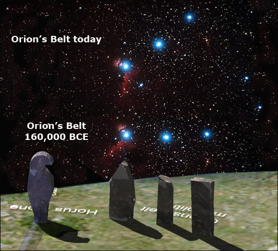
The first rough calculation was at least 25,000 years ago. But new and more precise measurements kept increasing the age. The next calculation was presented by a master archaeoastronomer who wishes to remain anonymous for fear of ridicule by the academic fraternity. His calculation was also based on the rise of Orion and suggested an age of at least 75,000 years. The most recent and most acurate calculation, done in June 2009, suggests an age of at least 160,000 years, based on the rise of Orion -- flat on the horizon -- but also on the erosion of dolerite stones found at the site.

Some pieces of the marker stones had been broken off and sat on the ground, exposed to natural erosion. When the pieces were put back together about 3 cm of stone had already been worn away. These calculation helped assess the age of the site by calculating the erosion rate of the dolerite.

South Africa has long been regarded as the Cradle of Humankind, but it looks like just a tiny fraction has been discovered up to now.

Now I'm actually wondering about a lot of things which might be connected.

• I'm reminded of the original meaning of the word Zulu, which means 'people of the stars' according to Credo Mutwa.

• I've done some presentations for Limpopo Province tourism in the past, and learned about Mapungubwe, an ancient kingdom right on the border with Zimbabwe.

SA_BW_ZW.jpg


Mapungubwe is most well known for this famous gold foil rhinoceros which was excavated there.

690-1823-2661-0_181101.jpg


• And then, as you can see, the Zimbabwe ruins is just North of Mapungubwe, so I'm wondering how far North this civilization actually stretched, and if it was a series of kingdoms.

What seems to be evident, is that gold was central to their existence.
 
Truly fascinating! thank you for this interesting info.
If you have any more links that you have you come across with further information they would be gratefully received!
al
 
Amazing!

From the article:

When explorers first encountered these ruins, they assumed that they were cattle corals made by nomadic tribes, like the Bantu people, as they moved south and settled the land from around the 13th century. There was no previous historical record of any older civilization capable of building such a densly populated community. Little effort was made to investigate the site because the scope of the ruins was not fully known.

It makes one wonder how many more ruins yet to be found are there under the same conditions, taken as nature's ornaments or as some recent tribe's constructions.

and further ahead in the same article:

The region in Africa where one can find the greatest level of mitochondrial diversity (green) and the region anthropologists postulated the most ancient division in the human population began to occur (light brown). The ancient metropolis in located in this latter (brown) region which also corresponds to the estimated age when the genetic changes suddenly happened.

I'm yet to read the rest, have to work and will leave it for now. I wonder whether this won't be conveniently brushed aside as so many other findings
 
I have now followed the N4 Northwards on Google Earth from Machadodorp, and all along the right hand side of the N4 one can see scattered unexcavated ruins, and then when you get to the little interchange, just underneath there's another big 'village'!

googleEarth3.jpg


I zoomed in a little:

googleEarth4.jpg


This is right in the middle of civilization, unexcavated!

This link says it stretches all the way from South Africa to Kenya and beyond, which means they populated the area along the mineral belt (Great Rift Valley), which was again identified by Cecil John Rhodes and his stooges in modern times.

From my National Geographic African Adventure Atlas:

At it's most dramatic in East Africa, the Great Rift Valley was formed some 20 million years ago when violent subterranean shifts resulted in the collapse of mammoth tracks of land situated along parallel fault lines, causing volcanic eruptions of molten rock. Today, this massive fissure in the earth's crust stretches 9 500km (6 000 miles) from Lebanon to Mozambique, and no less than 800km (500 miles) between Lake Manyara and the Red Sea. The dramatic inclines of its valley walls slice between 50km (30 miles) through the width of the African landscape. Apart from Ethiopia on the Horn of Africa, the two countries that are home to the most theatrical inclines of the great valley are Kenya and Tanzania, both of which are characterized by high-lying inland plateaux and fertile coastal belts dotted with tropical islands.

So the ancient volcanic eruptions brought all the diamonds to the surface, which might also have sparked their interest, along with all the gold and other minerals.
 
I have looked a little into Michael Tellinger.

From his wiki page:

Tellinger published his first book Slave Species of God in 2005. The work is the result of a 25-year obsession with the pseudoscientific writings of Zecharia Sitchin, who idiosyncratically translated ancient Sumerian clay tablets and theorized about the early creation of man by the Anunnaki. Tellinger also frequently publishes articles on the topic via his website www.slavespecies.com.

His book:

book.gif

His latest book, Adam’s Calendar, he wrote in conjunction with Johan Heine, who first discovered the ancient stone ruins of South Africa.

AdamsCover.jpg


Here’s a YouTube video about Adam’s Calendar.

I appears to me that it’s currently only explored by these 2 guys (apparently in conjunction with some geologists, astronomers, archaeologists and historians that they involved in the project), Michael Tellinger and Johan Heine, while one would expect swarms of archaeologists streaming to these locations. Him being such a big Zecharia Sitchin fan, one can expect the theories developed to have a strong Sitchin / annunaki slant... in fact it already has, with the gold connection.
 
I have now gone East of the initial location (and NE and SE), and the whole place is just full of it.

Have a look at this:

googleEarth5.jpg


This one's also strange:

googleEarth6.jpg


And some more:

googleEarth7.jpg


googleEarth8.jpg


googleEarth9.jpg


googleEarth10.jpg


googleEarth11.jpg


Sometimes roads and mines go straight through them:

googleEarth12.jpg
 
I tried to find archaeologists not connected to these 2 guys, to get more findings on Mpumalanga Province and archaeology related subjects in the region.

Both these two people - Cyril Hromnik (archaeologist) & Rob Milne (historian) - are 'new school'.

_http://www.mpumalanga.com/what_to_do/what_to_do.asp?id=built_features&DID=3

Mpumalanga's long and turbulent history has littered its landscape with an eclectic collection of shrines, ruins and monuments.

The earliest are undoubtedly Mpumalanga's 25 000 San and Khoisan year old cave paintings. The hundreds of paintings and engravings are believed to record man's interaction with the spirit world, and are still revered by modern visitors.

We are, however, less certain about the origin of the thousands of more recent stone ruins, including what appear to be mountain-top shrines, fortifications, and cities. The ruins, dating between 1500BC and colonial times, have been credited to everyone from a lost Hindu civilisation to powerful gold-mining African empires that predate Great Zimbabwe.

But, the building hasn't stopped. Each successive wave of colonisation has left its mark, invariably in stone. Mpumalanga's newest monuments, celebrating democracy, seek to pay homage to the past.

We have compiled a brief guide to some of the province's more accessible or unusual 'human' landmarks:


ECHOES OF A GOLDEN AGE...

Populist archaeologists led by Cape Town scholar Cyril Hromnik suggest that Mpumalanga was settled by an ancient sea-faring Hindu culture thousands of years ago.

The mysterious colonists are believed to have erected temples and astronomical observatories on mountain tops and built strong stonewalled cities, from which they hunted ivory and mined the region's ample gold, red ochre and iron reserves.

Hromnik, an academic at the University of Cape Town, insists that the region was empty of indigenous peoples at the time and suggests that the legacy of the Hindu trade empire is still reflected in local place names such as Komati, and in the reverence southern Africans still have for cattle.
Hromnik and his converts conduct tours of the most prominent ruins.

Mainstream historians dismiss Hromnik's theories, however, insisting that the ruins littering Mpumalanga are actually the remains of successive kingdoms of indigenous peoples. Archaeologists are beginning to restore this forgotten history at places such as Legoya near Ermelo, where a virtually intact town of 90 corbelled huts built from rock have been discovered.

The settlement, which appears to have been abandoned during the bloody Difaquane wars 250 years ago, covers a four hectare mesa, near picturesque streams, a waterfall and forests. The unique site, considered the largest and best preserved of its kind in southern Africa, is accessible to intrepid travellers.

The above theory will never have an audience, because it's politically inconvenient, due to land being such a sensitive issue in SA.

Rob Milne (historian) has made the following discovery in Mpumalanga:

_http://robmilne.com/?q=node/22

An Introduction to the Orion Mysteries of Boomplaas

No one knows who executed the many thousands of engravings on the granite boulders at Boomplaas, and when or why the first engravings were made. No one even goes there anymore, except for the farmer who occasionally checks on his grazing cattle. This is a very powerful place, where the rocks are so highly magnetized that a compass reads 45 degrees off-course. During the past 10 years I have studied the engraved boulders in this peaceful yet highly charged setting between the Drakensberg and Steenkampsberg Mountains, and the secrets of this place are slowly unfolding.

Join me in this exploratory walk as we discover the obtuse messages that the ancient Shamans engraved on key boulders, and uncover how they mirrored the Orion Constellation in this sacred place. This is one of three rock engraving sites in South Africa that has been laid out to reflect Orion, and links us with similar ancient layouts in different parts of the world. The ancient Egyptians did this at Giza; the Hopi in Arizona; and the Celts on the Peaks of Loughcrew in Ireland.

Prehistoric man had an affinity for the stars – they were his nightly entertainment, predictor of the seasons, and his connection with the Creator. The Orion Constellation is dominant in the summer night sky in South Africa and the Namaqua people (who at one time most likely engraved some of the Lydenburg stones) saw a hunting scene in the night sky. The husband of the daughters of the Sky God, Aldeberan, shot his arrow (Orion’s sword) at three zebras (Orion’s belt) but it fell short. Afraid to retrieve his arrow because of the lion (Betelgueuse) and not wanting to go home empty-handed, the husband sits in the cold watching the zebra with his wives (the Pleiades) behind him.

There are two Orion’s belt alignments at Boomplaas: One reflects the belt as it appears overhead at midnight on 22nd December – the summer solstice. The engraved stones making up this alignment are Key Stone (Mintaka), Round /Tortoise Rock (Alnilam), and Kaalkop (Alnitak). In the second Orion’s belt alignment Round/Tortoise Rock becomes Alnitak, lining up with Simulacre (Alnilam) and Gary A. David Gateway (Mintaka). This mirrors the appearance of Orion’s belt as it rises just before sunrise at the winter solstice on 21st June.

Each of the engraved boulders in the two Orion’s belt alignments are unique in terms of size, shape, and engraved subjects. Key Stone is nearly 1.4 meters high, highly polished, and shaped along its east-west axis into a sharp ridge. It is covered with deeply pecked line engravings, at the centre of which is an engraving of a rock hydrax or tree mouse. Round (Tortoise) Rock is shaped like the shell of a tortoise or a plano-convex lens, and is covered with joined concentric circle engravings. Kaalkop (bald head) is less than a meter high, polished, and engraved with elongated cupules and joined concentric circles. Simulacre is the name that I have given to a huge (1.3 meter by 2.2 meter) polished boulder that looks very much like a giant carved face – in fact it looks remarkably like the profiled face of Pharaoh Tuthmosis I. The Gary A. David Gateway is a giant split boulder nearly a meter high, the gateway being nearly 4 meters long on a precise north-south line. It is covered with joined concentric circle engravings, as well as having two flat engraved basins running next to the gateway. The engravings on the eastern basin show Orion’s belt, the phases of the moon, and Sirius.

Also featured on the DVD are circles of giant engraved boulders, a stellar observatory, and a rare therianthrope (half man, half animal) engraving that bears a strong resemblance to one of the ceramic “Lydenburg” heads, which dates to the Early Iron Age. The site is littered with stone tools, suggesting that the engravings were started in the Stone Age, and continued for at least 2 000 years until historic times.

The African continent holds and hides vast cultural treasures dating back to antiquity. For a number of political, social and practical reasons these treasures remain largely hidden from the public eye.

South Africa, in particular, is host to a number of valuable sites graced with an uncertain future in the face of socio-economic development, relic hunting and vandalism.

The Boomplaas Complex is one such site.

Stretching for kilometers along the Highveld escarpment not far from the town of Lydenburg (Mashishing), Boomplaas has an incredibly rich and fascinating history in modern times but the petroglyphs and stonework from antiquity are by far the most significant aspect of this landscape.

Rob Milne is a South African explorer, historian and author well known for his definitive works on the Anglo-Boer Wars. It was during the course of battlefield research that Rob Milne began to find rocks and stones of particular cultural and historic significance. In addition to the unusual finds relating to size, shape and engravings, Rob discovered that these rocks and stones would frequently be aligned in a very calculated and ordered way.

Somewhere along the forty odd years of walking the open African veld and sleeping under wide open skies Rob discovered that many of the stone alignments which he had recorded corresponded to particular star alignments visible from the southern hemisphere.

The Constellation of Orion was a particularly popular choice with the ancients and Rob has encountered, mapped, recorded and measured several such alignments in South Africa – Boomplaas being one such case.

Alignments such as these are not unique in the world, of course, and have been the focus of interest for some time. There are many well recorded alignments in the Americas, Europe and Asia. The reasons for these alignments are generally believed to be practical, ceremonial and architectural.

The most practical application of alignments is the calendar. By simply looking around him, ancient man could establish not only the time of day but also the season and related impending events like rains, veld fires and animal migrations.

Ceremonial usage of alignments to reach ‘Tribe’, “Spirit” and the “Beyond” are common throughout the world and closely associated to ritual. The rituals of conception (marriage), birth and death being the most common.

Architectural deployment of alignment is possibly the oldest form of human organization known to Man. In Africa today, architectural alignment is practiced both in the traditional villages and the modern cities alike.

There are compelling reasons for applying star alignments – or “star maps” – to all three forms of man made alignments be they practical, ceremonial or purely architectural. These are likely to remain speculative forever, however. Some of these formations are millions of years old and possibly of a different scale to today’s human dimensional reality.

One should not forget, of course, the theorists who believe that both alignments and inscriptions hold particular significance in recording the history of Mankind – and its origins – which may conceivably have its roots outside our Solar System or even beyond Orion.

The true value of Rob Milne’s field work is not derived from the answers it provides but rather from the questions it poses and the body of evidence which it contributes towards the origins of Mankind debate.

ORION DISCOVERY METHODOLOGY

Whereas Orion alignments are not new to the world, the practical application of this notion in field exploration may well be. By reversing the alignment concept Rob Milne has turned an exploration finding into a tool of discovery.

Find the “Three Sisters” and the stars reveal the rest…

Cigar-Shaped_petroglyph___concentric_circles.jpg


CupulesRainbowsRhinoRock.jpg

With regard to the magnetizm, bare in mind that this area falls within one of Earth's 10 vile vortices, which might also explain the need for monuments, shrines, calendars or temples…or even be responsible for choosing the spot in the first place..

Earths_Vile_Vortices.jpg


...G'night!
 
E, this stuff is really amazing (and so is the time and energy you spent on putting your post together). Thanks for collecting this info!

I have a copy of Slave Species of God but haven't read it yet -- how strong is your recommendation of it?
 
[quote author=shijing]
E, this stuff is really amazing (and so is the time and energy you spent on putting your post together). Thanks for collecting this info!
[/quote]

:)

[quote author=shijing]
I have a copy of Slave Species of God but haven't read it yet -- how strong is your recommendation of it?
[/quote]

I first learned of Slave Species yesterday when I looked into Michael Tellinger. I'm afraid I know nothing about it, apart from the fact that his inspiration came from Sitchin. The only way we'll become any wiser about this discovery, is if it's excavated. Until then, it's anyone's guess.
 
Hi everyone!

This shows a very fascinating find, even if it turns out that there might be some "far out" speculations that are not in accordance with available data mixed in with the real research. This is something I concluded happened with Sitchin, based on some of Laura's articles about his Nibiru (12th planet) theory, for example. (http://www.cassiopaea.org/cass/sitchin.htm). However, I would hope that when one is able to dig deeper, with the proper application of discernment, one can help separate the real research from the speculation.

What I especially look for in these discoveries and research nowadays, is the methods by which they try to date the findings. This came to my attention with Laura's work [Secret History of the World] and how she pointed out the great difficulties in doing the dating. I think when one looks into the dating methods for themselves, one often wonders how so many articles and books we read claim dates with such certainty. It feels so dishonest. It is my understanding, that in nearly all cases, dating estimates are made to be too young.


So I took a look at this part of the article(s) at _http://www.viewzone2.com/adamscalendar22.html that talks about dating.

In this case I gather they are getting the estimates of a civilization existing 160,000 years ago (or more) because of finding [what is believed to be] a stone calendar. To put it simply, if one calculates the time when a certain celestial alignment occurred (in this case when the three stars of Orion's belt were positioned flat, or horizontal, against the horizon), and try to take into account the earth's wobble, then a date can be estimated when 3 stones were in alignment with these "conspicuous" stars. However, I noted that the article said these calculations were first 25,000 years ago, then 75,000 years ago and finally 160,000 years ago. So I concluded that these calculations, which are not revealed in the article so we could try them ourselves, (not that I would have the skill to do the calculations), they must be far from straightforward.

Then maybe I just missed it, but I did not catch why the 200,000 year has gotten thrown in this article so prominently.

Well, that is something isn't it: If ancients could leave something behind to basically TELL us the date when they were around!!

I had an amusing thought: what I should do this weekend, is set up my own stone calendar in the backyard. I will set it up celestial alignment of the 3 stars of Orion's belt for about 100,000 years ago. I want to do this just so I can really mess with the minds of future archaeologists! [Look Bob, this proves that ancient Finns were making cell phones 200,000 years ago!!!] :D Yeah, maybe I am a bit of sicko.

However, more seriously, another thing that caught my attention, to assist in dating was this based on erosion:

adams calendar article said:
Some pieces of the marker stones had been broken off and sat on the ground, exposed to natural erosion. When the pieces were put back together about 3 cm of stone had already been worn away. These calculation helped assess the age of the site by calculating the erosion rate of the dolerite.

I am new at this, (very NEW - hey, I am a software engineer, not an archeologist!) but I had not come across this way to estimate dates. There has got to be some big assumptions about rate of erosion: how much time the pieces were exposed to the elements (not covered), how the climate may have changed over time, and taking into account the hardness of the rock. Just for starters.

Sorry I could not offer much more than this not very well researched and somewhat naïve posting - but I wanted to participate because I REALLY am fascinated by this stuff! Seriously folks, if I could restart my career, I would toss away all the software engineering and get into the studies of archeology, anthropology, linguistics, meteorology, etcetera and try to unravel the ancient secrets of the history of mankind by trying to "connect the dots".

By the way, there was a thread started about the Pyramids in Bosnia. What struck me about this find, (which I found just as fascinating as this one) is the strong likelihood that their discovery will show advanced peoples living at a time far older than conventional history teaches.
http://www.cassiopaea.org/forum/index.php?topic=1356.15

_Breton_

[Edit: I might add a link to the very recent thread that talks more about the problems of dating that I just noticed (hard to keep up with you all!):
Doubts About Accuracy of Genetic Dating Techniques
http://www.cassiopaea.org/forum/index.php?topic=14640.0]
 
E said:
I found something very interesting online today. I'm just going to supply the link here, instead of copying the whole lot in here.

http://www.viewzone.com/adamscalendar.html

It was reported in SOTT as well! :cool2:

https://www.sott.net/articles/show/196147-Ancient-Human-Metropolis-Found-in-Africa
 
Windmill knight said:
It was reported in SOTT as well! :cool2:
https://www.sott.net/articles/show/196147-Ancient-Human-Metropolis-Found-in-Africa

And the succinct comment added there is so excellent!

Comment: In the last segment, the author is sidetracked into speculation about a non-existant planet called "Nibiru." But what if the Sumerian 'Genesis' mixed into its founding mythology "alien interactions" alongside knowledge of cyclical catastrophes? While "Nibiru" as a planet seems an unsupportable concept, there is alot of evidence to suggest our sun has a dark star companion that periodically knocks a cluster of comets from the Oort Cloud our way. As Laura Knight-Jadczyk writes in Has Nibiru/Planet X Been Sighted?

Sitchin proposed that a "10th Planet" caroms through the inner solar system. Scientific evidence does not support a body the size he suggests, entering into the inner solar system. However, science can support a cluster of comets spread out in space that returns at 3,600 year intervals.

Sitchin suggests that his 10th planet is inhabited by the Annunaki/Nefilim. He claims that they are our creators and masters. His ideas are tremendously out of synch with the strong circumstantial evidence about the alien presence on this planet. Sitchin's ideas are also flawed for the other reasons we have already mentioned, though he has certainly produced inspired work in his interpretations of the Sumerian texts as being related to "alien interactions" and the periodic return of something!
 
Thanks for your additions Breton.

Breton said:
In this case I gather they are getting the estimates of a civilization existing 160,000 years ago (or more) because of finding [what is believed to be] a stone calendar.

What they need to find now is a graveyard. The skulls will show whether this was an African tribe or some other people, and also give an estimate of the time period.

Original article on Viewzone said:
The image [top of page] is a close-up view of just a few hundred meters of the landscape taken from google-earth. The region is somewhat remote and the "circles" have often been encountered by local farmers who assumed they were made by some indigenous people in the past. But, oddly, no one ever bothered to inquire about who could have made them or how old they were.

Not surprising, because they do resemble traditional African villages (kraals) to this day. Even if it turns out to be some recent indigenous people, it's still part of our heritage and worth excavating.

spaceball.gif


african-village-aerial-shot.jpg


TAF2684.jpg


stock-photo-aerial-photograph-of-an-african-village-in-chad-24008692.jpg


In fact, I'm actually leaning towards this at the moment. There is a possibility that the 'calendar' isn't connected to these villages, that they are from two different time periods.

Windmill knight] [quote author=E said:
I found something very interesting online today. I'm just going to supply the link here, instead of copying the whole lot in here.

http://www.viewzone.com/adamscalendar.html

It was reported in SOTT as well! :cool2:

https://www.sott.net/articles/show/196147-Ancient-Human-Metropolis-Found-in-Africa

[/quote]

Yeah, as soon as I started searching online for this, I saw SOTT had covered it. Seriously, do you guys miss anything?!? :cool:

At least we were able to expand on the topic a little. :cool2:

Breton said:
Seriously folks, if I could restart my career, I would toss away all the software engineering and get into the studies of archeology, anthropology, linguistics, meteorology, etcetera and try to unravel the ancient secrets of the history of mankind by trying to "connect the dots".

I share your sentiments!

indy.jpg
 
Back
Top Bottom