Crazy Storm Weather and Lightning - Global

Weather radar picks up mysterious shadow across three states ‘caused by huge dragonfly swarm’
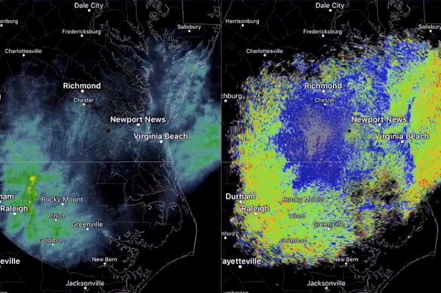
The satellite images appeared as rainclouds, but baffled meteorologists as no rainfall was recorded: NWS Wakefield/Twitter

Sunday Sept. 22, 2019 - An enormous mystery cloud has baffled US meteorologists this week who spotted the shape stretching over parts of Indiana, Ohio and Pennsylvania, but saw no rainfall.

The National Weather Service spotted the “conundrum”, and suggested it could be a swarm of “bugs”, however the altitude was so high, they were initially sceptical such a massive number of creatures could be flying so high.

NWS Wakefield said on Twitter: “No rain around the region with decent returns on radar. Usually we’d think we’re seeing bugs. Dual polarization radar products argue otherwise and some of these returns are above 10,000ft”.

The service added: “Migrating dragonflies is a possibility...they migrate in fall, usually prior to cooler weather arriving, and towards areas where more precipitation has fallen recently. That said, not sure DFs can fly that high or if they move in numbers great enough to produce these returns”

Another National Weather Service station in Cleveland also picked up the huge cloud and asked users on Twitter to guess what was causing it.

They later tweeted: “While we are not biological experts, we have determined (through input from our followers) that it’s most likely dragonflies mixed with other insects/birds!”


People on Twitter confirmed huge numbers of dragonflies were spotted in the region.

“I had so many in my yard. Felt like King Kong with all the planes around him,” wrote George Cheripko in reply to the NWS tweets.

“Definitely dragon flies,” said another person. “We have thousands flying around our yard and the field next to our yard.”

A common green darner dragonfly. The species is found from the northern US states down to Texas, Mexico and Panama. They are also found in the Caribbean, Tahiti, Japan and China (Getty)

Jason Dickhart added: “I saw a million dragonflies in my yard yesterday. Squirrels were going nuts.”

The species is reportedly the common green darner – named due to their resemblance to a darning needle. They fly south at the end of the summer, following their prey – mosquitoes and flies – to warmer climates in the southern states and central American countries.

Dragonflies were among the first winged creatures to evolve. Some enormous species emerged during the Paleozoic era, when oxygen levels were higher, with fossils recording individuals with wingspans of over two feet.

Modern dragonflies have wingspans of 2 – 5 inches, but despite their small size have previously been tracked by scientists with some individuals flying over 100 miles in a single day.
 
It seems, the Dragonflies detected an early cold snap on the heels of the Fall equinox?

Major snowstorm to deal northern US an early taste of winter
https://www.accuweather.com/en/weat...eason-eyes-northern-us-southern-canada/539888

Thursday September 26, 2019 - Fall is not even a week old yet, some parts of the northern United States and the Canada Prairies are bracing for a major snowstorm that weather officials are warning could be historic.

The general accumulation of snow, likely to be measured in feet in the highest elevations, will occur along with a substantial drop in temperature this weekend.

Because of the early-season and severe nature of this storm, people in the backcountry will be at risk for becoming stranded for days with well-below-freezing temperatures at night.

Rain showers are forecast to occur Thursday into early Friday over portions of southeastern British Columbia, southwestern Alberta, northern Idaho and western and central Montana.

USLateSept.jpeg

However, cold air will surge southward across western Canada around the same time a storm will track eastward from the Pacific Ocean, and a change to snow will take place from north to south and from higher elevations to lower elevations later Friday and Saturday.

The change in temperature could leave some people with a case of weather whiplash. Temperatures are forecast to plummet 25-50 degrees Fahrenheit (12-25 degrees Celsius) from the middle of this week to this weekend. Highs in the 50s and 60s F (15-20 C) at midweek will be replaced with highs in the 20s and 30s (5 below zero to 4 above zero C).

"This is the type of setup where it will snow not only in the mountains but also down to the valley floors and away from the foothills," Brett Anderson, AccuWeather senior meteorologist, said.

page-15-2.jpg

In the mountains and intermediate elevations, a general 1-2 feet of snow is forecast to fall with an AccuWeather Local StormMax™ of 40 inches over the east-facing slopes of the Sawtooth, Flathead and Lewis and Clark ranges in northwestern Montana.

A few inches of snow may fall in the valleys and over parts of the High Plains and Prairies.

On Wednesday, the National Weather Service (NWS) in Missoula, Montana, warned that the storm has the potential to be "historic" due to its occurrence so early in the season. While snowfall accumulations will be lower across the valley, there will still be life-threatening backcountry conditions, hazardous travel, wind damage to docks and marinas and agricultural damage from record low temperatures, the NWS warned residents in the area.

Snow is also likely to spill west of the Continental Divide. Portions of northern Idaho, northeastern Washington and south-central British Columbia are likely to see a few inches of snow over the mountains.

A small accumulation of snow is also likely on the eastern slopes of the Washington Cascades.
One factor forecasters are notably concerned about is the amount of foliage still on trees.

"It's a very big concern here; we're just beginning to turn our colors, so trees are fully loaded with foliage here," LeeAnn Allegretto, a meteorologist with the NWS in Missoula, told AccuWeather. "Snow will have a huge impact and will likely cause downed trees and potentially plenty of damage/power outages."

Allegretto added that she and her coworkers believe the amount of snowfall on foliage-laden trees will have the biggest impact, but the strong winds and record-challenging cold will also be dangerous.

Cities likely to be hit with accumulating snow include Calgary and Lethbridge, Alberta; Regina, Saskatchewan; and Great Falls, Butte and Missoula, Montana.

Missoula is forecast to experience a high temperature in the upper 30s on Saturday; on Tuesday, highs flirted with 70 at Missoula International Airport.

Snowfall is likely to cause substantial travel delays through the mountains and over the passes, and could be heavy enough to shut down travel altogether.

"There will be heavy accumulation on the roads over the passes with this storm," Anderson said.

Travel along many secondary roads, as well as Interstate 15, I-90 and Canada's Highway 1 may be adversely affected and dangerous in some locations.

A substantial amount of snow is forecast to fall on Glacier National Park and Yellowstone National Park.

The September snowfall in Missoula has the chance to be a record-setting event. Allegretto said it's been 36 years since September snow was recorded in Missoula. With up to 2 inches forecast in the Missoula Valley, it could turn out to be the greatest one-day September snowfall total since 1934 when 1.5 inches fell.

Enough of an east to northeast wind may accompany the snow to cause blowing and drifting with poor visibility over the higher elevations.

Over the lower elevations, where snow initially makes roads wet, subfreezing temperatures at night can create icy spots during and following the storm.

During Sunday night and Monday night, nighttime temperatures may challenge record lows.

Snow this early in the season is not unheard of in this part of North America.

For example, on Sept. 8-10, 2014, Calgary received about 10 inches (25 cm) of snow. Just last year, a little snow fell on Calgary, Great Falls and other locations in the region from Sept. 27-30.

Earlier this September, a few small pockets of snow fell on the high country of the Rockies.
 
Watching nature is a great indicator of weather. But with all the "natural" alterations, even nature can become confused. When we see shoreline birds flying more inland or just disappear, we know weather is coming. My grandfather was a lifelong fisherman and could make predictions based on the currents of water, air and the movements of animals. I wished I paid more attention to his observations when I was younger.

Here in Puerto Rico, we were waiting for Karen. Made preparations and instead had a good shaking up by a 6.3 earthquake. Oy. Give Thanks Karen went about her business. Many of us realize all we can do is hope for the best, but prepare for the worse and stay calm. All the anticipation creates a negative energy loop. In reality, none of us knows what the next second will unfold. We are not bodies, but souls having a human experience and the only thing we have control of, is ourselves. Be Safe. Be Well.
 
After Lorenzo (a hurricane that travelled all the way over the Atlantic reaching category 5 and ending up at Great Britian/Irland) it seems to me that in the last 2-3 days another hurricane like storm developed way up north off the coast of Nova Scotia and is currently reaching even higher wind speeds than Lorenzo and a greater size, also traveling toward Great Britian.

Take a look at this:


Couldn't find any information on the net about the development of this storm right after Lorenzo, forming in pretty cool water up north, seemingly reaching even higher wind speeds and extent currently. From my layman perspective it very much looks like another hurricane that has developed far up north, with higher wind speeds than Lorenzo at the same latitude and a greater expanse area wise.
 
I find it curious how the path of Lorenzo aligns partially with the Mid-Atlantic ridge. I blended two images (from Hurricane Lorenzo (2019) - Wikipedia and Mid-Atlantic Ridge - Wikipedia) and it matches more than I even thought. Maybe there was/is some electrical exchange between inner earth and atmosphere through the ridge, triggering the hurricane? The new one is also over the ridge it seems. Also note how Lorenzo got weaker when it left the ridge.
LorenzoMidAtlanticRidge.png
 
In this video-forecast-report you can see the size and speed of the storm (mentioned in my last post above) in the background while the reporter says nothing about it. You can see it on Sunday as well as on Monday.


I searched for a while now and couldn't find any information on that storm anywhere. At one point I came across a website which might suggest that the storm is called "Karen" although I'm not sure about that and tent to think that they talk about another storm. My guess is that they didn't name that storm yet and will not do so in the future. Not every storm get's a name as far as I know.

Turns out they call this new storm currently on the way to Britain "a 1,000-mile wide low pressure vortex" that is predicted to create "40ft waves and up to 70mph winds" with " two WEEKS' worth of rain for this time of year falling in just a matter of hours", "all from Monday to Wednesday ".


Notice that they also mention the previous hurricane Lorenzo and that it was 500 Miles wide (half the size of this one) and that Lorenzo reached similar scores in terms of wind and wave sizes, see here:


So basically this new storm/vortex is much bigger with similar or even stronger winds and waves predicted, shorty after Lorenzo, also traveling towards UK/Scotland, while this one hasn't been named yet and is named a "low pressure vortex" instead, although from a layman perspective, it very much looks like hurricane would look like, just that it developed way up north in the Atlantic (in contrast to hurricanes), in a pretty short period of time after Lorenzo.

Take a look at it again, here you can also go back in time (and forwards in time) to compare wind speeds and the development of this storm compared to Lorenzo:


It looks stronger in every aspect as of now, including the size.

Quite interesting that this one doesn't attract so much attention, even though, by the looks of it, it could be at least as severe as Lorenzo and about double the size. Could it be that it doesn't attract so much attention, because it developed into such a monster "hurricane looking" storm in pretty cold waters way up north in a short period of time, which doesn't quite fit with the models of "how hurricane type vortexes develop"? Could it be that some sort of cover up is going on to mask the "unusual" behavior of that storm by not giving too much attention to it? Or maybe because it is called a "low pressure vortex" it just doesn't attract so much attention, since "hurricane" is "another category", better suited for sensational coverage? Or because it is not predicted to be as severe as Lorenzo on the land? Although yet again, the predictions of this current one are as severe or worse compared to Lorenzo. Also notice that in the first article it states:

However the experts are still divided on their predictions as long-range forecasting is notoriously difficult.

They simply don't know how it will develop, although in Lorenzos case, they seemed to be pretty certain before it hit. Notice also that in the same report in the first link above, they say about Lorenzo:

Hurricane Lorenzo, which was a maximum Category 5 storm before hitting the Azores, was the strongest hurricane ever recorded so close to Europe.

So basically this new storm is as of now predicted in every category to be at least as severe and destructive (both in terms of wind and waves) as Lorenzo, which was, quote, "the strongest hurricane ever recorded so close to Europe", while this one looks like double the size and from the predictions as well. Same picture on the satellite images/rendering (see last link above); it could be even worse, while at the same time it is hardly mentioned as such a severe occurrence. Quite strange to me. If it turns out to be as predicted and shown in the satellite images, this one could in fact be more severe in every category as "Lorenzo, the strongest hurricane ever recorded so close to Europe", which just reached Britain a couple of days ago.

PS: details
 
Last edited:
Looks like winter is going to come in like a lion. We certainly did not have much of a summer despite a couple short "heat waves" where it did, indeed, get pretty HOT! It just didn't last.
 
Turns out they call this new storm currently on the way to Britain "a 1,000-mile wide low pressure vortex" that is predicted to create "40ft waves and up to 70mph winds" with " two WEEKS' worth of rain for this time of year falling in just a matter of hours", "all from Monday to Wednesday


WARNING: Interaction of #FrenteFrío3 , trough and low pressure will cause heavy rains to torrential in Veracruz, Tabasco, Chiapas, Oaxaca, Campeche, Yucatan and Quintana Roo from Monday to Wednesday. Floods, river floods and landslides are very likely.

Simply, Surreal!

VAPOUR - 2019 Alberta Storm Chasing Montage (4K)
Oct 4, 2019
Hi, here's my short time-lapse montage from this years storm chasing season in Alberta. It was a short but very punchy/active season pumping out incredible cloud to ground lightning, a tornado and back to back supercells. It was definitely a season to remember
 
Last edited:
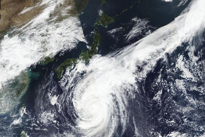
A pretty sizable typhoon is currently approaching Japan:


As of now the prediction (October 12) via satellite looks like this:

 
Turns out they call this new storm currently on the way to Britain "a 1,000-mile wide low pressure vortex" that is predicted to create "40ft waves and up to 70mph winds" with " two WEEKS' worth of rain for this time of year falling in just a matter of hours", "all from Monday to Wednesday ".

The „1000 mile low pressure vortex“ is currently hitting Britain:


Looks like this on satellite rendering right now:


With a pretty sizable wave size accumulation (looks bigger and much more extended than the wave front Lorenzo produced):


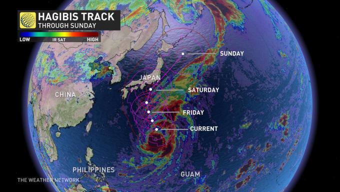
Thursday, October 10th 2019, 12:12 pm - Hagibis still a monster storm as it continues to trek towards Japan, after quickly gaining Category 5-like strength Video

Super Typhoon Hagibis, which is the Phillippine word for "speed" continued to maintain its intensity as a monster storm through Thursday with maximum sustained winds up to 240 km/h and gusts as high as 300 km/h. Hagibis is predicted to possibly become the strongest storm of the year as it moves closer to landfall in Japan over the weekend.

The storm, which developed over last weekend, took only 18 hours to rapidly intensify to super typhoon status, maintaining this Category 5 hurricane strength equivalent for much of this week.

Hagabis_track.jpg


As watches and warnings have been since dropped for American territories in the Pacific, including Guam, the next target looks to be Japan. It is currently moving in a north-northwest direction, but thanks to a front, it is expected to change to a northeasterly track Friday into Saturday.

The official track is expected to bring Hagibis near the main island, Honshu, by the weekend. Though expected to weaken, it is still predicted to make landfall as a Category 2-strength storm.

JAPAN PREPARES AS SUPER TYPHOON APPROACHES

The incoming storm prompted residents of central and eastern Japan to begin preparations on Thursday and brace for potential upcoming evacuations that could be ordered through the weekend. The Japan Meteorological Agency has already issued warnings of heavy rain, gale-force winds, high waves and dangerous storm surge.

In what's being call a "no brainer" situation, some rugby fans were still left "bitterly disappointed" by the news that at least two matches at the Rugby World Cup in Japan have been cancelled in anticipation of Typhoon Hagibis over the weekend.

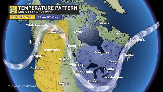
Because of the expected trajectory and strength of this storm, Weather Network meteorologists say it looks to influence the weather in western North America in the long range.

Check back often for updates as we continue to monitor this storm.

For the first time in over 30 years, the Rugby World Cup organizers cancelled Saturday's game between England and France as well as New Zealand's match against Italy due to the risk from the typhoon, while a Sunday game between hosts Japan and Scotland is also in doubt.

It was just last month when Typhoon Faxai hit eastern Japan, killing three people and leaving nearly 950,000 without power.

THE RAPID INTENSIFICATION OF HAGIBIS

Hagibis quickly intensified between early Sunday and Monday, attracting the attention of forecasters around the world as it raced from tropical storm to the equivalent of a Category 5 hurricane in just 18 hours.

"This is the most intensification by a tropical cyclone in the western North Pacific in 18 hours since Yates in 1996," tweeted Philip Klotzbach, a hurricane researcher at Colorado State University.


pattern_teleconnections.jpg

Check back often for updates as we continue to monitor this storm.


Flashback:
 
Thursday, October 10th 2019, 12:12 pm - Hagibis still a monster storm as it continues to trek towards Japan, after quickly gaining Category 5-like strength Video

Super typhoon on track to drench Japan’s main island
1791931-297201744.jpg

Japan is regularly hit by Pacific storms, including Faxai in September. (File/AFP)

October 10, 2019 - TOKYO: Japan is bracing for a super typhoon on track to hit central and eastern regions over the three-day weekend with potential damage from torrential rains and strong winds.

Hagibis, which means speed in Filipino, had maximum sustained winds of up to 270 kilometers (168 miles) and stronger gusts at noon Thursday near Chichi island in the Pacific, about 1,000 kilometers (620 miles) off Tokyo’s southern coast. It was moving north at the speed of 20 kph (12 mph) and is expected to weaken over cooler waters as it nears Japan’s main island.

It’s the equivalent of a Category 5 hurricane.

The Japan Meteorological Agency says the typhoon is forecast to hit ashore in the Tokyo area late Saturday and urged people to take precautions to avoid potentially life-threatening danger. Japan’s central Pacific coast may see torrential rains beginning Friday while high waves and tides may cause flooding.

Japan’s capital braces for what could be heaviest rain in 60 years
1793046-1566915911.jpg

This Oct. 10, 2019, satellite photo taken by NASA-NOAA's Suomi NPP satellite shows typhoon Hagibis approaching Japan, center left. (NASA Worldview, Earth Observing System Data and Information System (EOSDIS) via AP)

October 11, 2019 - TOKYO: A powerful storm approached Japan on Friday, threatening to batter its capital with the heaviest rain in 60 years, disrupting a Formula One Grand Prix and rugby’s World Cup and raising fears of transport chaos.

Typhoon Hagibis, which means “speed” in the Philippine language Tagalog, is due to make landfall on the main island of Honshu on Saturday, a month after one of the strongest typhoons to hit Japan in recent years destroyed or damaged 30,000 houses and caused extensive power cuts.

The typhoon could bring record-level rainfall and winds,” an official at the Japan Meteorological Agency told a news conference.

The storm could be the strongest to hit Tokyo since 1958 and people should also prepare for high waves and storm surges, the JMA said.

japan_typhoon.pdf
 
Week 15 (April 8 – 14, 2019) Contest Winners


“Beam me up, Scotty!
Rocket launch seen from Andenes.
It was quite a show a few days ago, when Andøya Space Center launched a rocket into space, releasing some chemicals into the atmosphere. It created some awesome light phenomena combined with the northern lights. This rocket has been planned for more than a year. And how lucky we were to be there at the right time.”


Continued:
 
Back
Top Bottom