Crazy Storm Weather and Lightning - Global

4K


Summer lightning over a harbor in Tällberg, Sweden.
Posted by Eleanor Imster in Today's Image | July 24, 2019
lightning-harbor.jpg
 
The death toll from the capsize of three Philippine ferries in bad weather rose to 31 on Sunday as rescuers found more bodies, a coast guard official said.

Death toll in capsized Philippine ferries climbs to 31
A handout photo from the Philippine Red Cross shows the capsized ferries off the waters of Iloilo City, Philippines August 3, 2019. Picture taken August 3, 2019. Philippine Red Cross/Handout via REUTERS

A handout photo from the Philippine Red Cross shows the capsized ferries off the waters of Iloilo City, Philippines August 3, 2019. Picture taken August 3, 2019. Philippine Red Cross/Handout via REUTERS

The motorized, wooden-hulled boats were carrying a total 96 passengers and crew when harsh weather conditions caused the vessels to overturn off the central island of Guimaras and Iloilo provinces on Saturday.

The search continues for three more people still missing, Philippine Coast Guard spokesman Commander Armand Balilo said. The rest of the crew and passengers were rescued.

Disaster officials reported 11 deaths on Saturday. Balilo said a third ferry was not carrying passengers and all of its five crew members survived.

The number of casualties from the coast guard is higher than the death toll being reported by the Iloilo disaster agency which was at 25 as of 0900 GMT.

Scores of people die each year from ferry accidents in the Philippines, an archipelago of 7,100 islands with a poor record for maritime safety.
 
Hundreds stuck in India's financial capital Mumbai as heavy rain disrupts Mumbai rail service
Houses and temples are seen submerged in the waters of overflowing river Godavari after heavy rainfall in Nashik, India, August 5, 2019. REUTERS/Francis Mascarenhas

Houses and temples are seen submerged in the waters of overflowing river Godavari after heavy rainfall in Nashik, India, August 5, 2019. REUTERS/Francis Mascarenhas

Hundreds of passengers were stuck in India's financial capital, Mumbai, and nearby towns on Monday after two days of heavy rain flooded rivers and undermined railway tracks forcing authorities to cancel or divert dozens of long-distance trains.

Rivers in the western state of Maharashtra were flooded after authorities released water from dams made full after many parts on the west coast received more than 200 mm (8 inches) of rain.

Trains were canceled due to the heavy downpours and because a boulder fell on one line, railway authorities said on Twitter.

Schools and colleges in Mumbai and neighboring districts were also closed on Monday following a warning by the weather office of heavy rainfall, the Maharashtra chief minister’s office tweeted.

Financial markets were open in Mumbai, which is often touted as a potential rival to China’s financial powerhouse Shanghai but, like many Indian cities, is hampered by poor infrastructure.

Hundreds of houses and a few Hindu temples on the banks of the Godavari river were flooded in the neighboring town of Nashik after floodwater was released from a dam.
 
China issues 'red alert' as super typhoon approaches mainland
SHANGHAI/TAIPEI August 8, 2019 - China’s weather bureau issued a red alert early on Friday as super typhoon Lekima approached Zhejiang province on the eastern coast, after forcing flight cancellations in Taiwan and shutting markets and businesses on the island.

The National Meteorological Center said the typhoon, the strongest since 2014, was expected to hit the mainland in early on Saturday and then turn north. It has issued gale warnings for the Yangtze river delta region, which includes Shanghai.

Taiwan has already cancelled flights and ordered markets and schools to close on Friday as the typhoon heads northwest, cutting power to more than 40,000 homes and forcing the island’s high speed rail to suspend most of its services.

The island’s authorities issued landslide warnings after an earthquake of magnitude 6 struck its northeastern coast on Thursday, hours before the typhoon approached, which was forecasted to bring rainfall of up to 900 mm (35 inches) in its northern mountains.

More than 300 flights to and from Taiwan have been cancelled and cruise liners have been asked to delay their arrival in Shanghai. Some trains from Shanghai have also suspended ticket sales over the weekend.

Heavy rain and level-10 gales are expected to hit Shanghai on Friday and continue until Sunday, with 16,000 suburban residents set to be evacuated, the official Shanghai Daily reported.

China’s Ministry of Water Resources has also warned of flood risks in the eastern, downstream sections of the Yangtze and Yellow rivers until Wednesday.

China is routinely hit by typhoons in its hot summer months but weather officials said last week they have been relatively infrequent so far this year.
 
Wild winds ground flights in Australia, falling tree kills woman
SYDNEY Aug. 9, 2019 - Major airports at Australia’s two largest cities, Sydney and Melbourne, canceled flights on Friday as damaging winds swept southeastern states, killing one woman, destroying roofs and causing power outages.

The woman died after a gum tree fell on her moving car in the southeastern state of Victoria. Two children and the male driver were hospitalized, police said.

Strong winds blew the roof off a nursing home near Newcastle in the neighboring state of New South Wales, as gusts in excess of 100 km (62 miles) per hour swept through parts of the region.

The cold front also cut power to about 10,000 homes in South Australia, while airports in Sydney and Melbourne canceled more than 60 flights due to strong winds.

The Bureau of Meteorology (BOM) warned the tough weather conditions were likely to continue through the weekend.
 
Record-breaking hailstone in Colorado: 'Big hail like this can easily kill people'
https://www.accuweather.com/en/weat...hail-fell-in-colorado-broke-a-record/70009074 (Video)

August 15, 2019 - Monster hail fell from the sky and hammered areas of the central United States on Tuesday, shattering a state record. Earlier on Tuesday before the storms developed, AccuWeather Extreme Meteorologist Reed Timmer warned that Colorado's state hail record could be in jeopardy given the intensity of the storms that he saw developing.

His prediction came to fruition on Tuesday afternoon when a hailstone with an unofficial measurement of a maximum diameter of 4.83" fell in Bethune, Colorado, on Tuesday afternoon. The record was confirmed on Wednesday evening by the Colorado Climate Center and the National Weather Service office in Goodland, Kansas. The previous state record in Colorado was 4.5 inches.

record hail graphic CO


As the Colorado Climate Center said on Twitter, photos indicate that the stone could have been even larger than recorded due to the time in between its falling and when it was put in the freezer.

The weight of the record-breaking hailstone came in at 8.5 ounces.
 
Four die, more than 100 hurt in thunderstorm in Poland's Tatra mountains
A TOPR (Tatra Volunteer Search and Rescue) helicopter and an ambulance are seen as rescuers conduct a rescue operation after a thunderstorm in the Tatra Mountains, in Zakopane, Poland August 22, 2019. Agencja Gazeta/Marek Podmokly via REUTERS

A TOPR (Tatra Volunteer Search and Rescue) helicopter and an ambulance are seen as rescuers conduct a rescue operation after a thunderstorm in the Tatra Mountains, in Zakopane, Poland August 22, 2019. Agencja Gazeta/Marek Podmokly via REUTERS

WARSAW August 22, 2019 - Four people, two of them children, died and more than 100 were injured during a thunderstorm in Poland’s Tatra mountains on Thursday, Prime Minister Mateusz Morawiecki said.

A fifth person was killed by the storm in the West Tatras in neighbouring Slovakia, mountain rescue services reported.

Lightning hit a group of tourists on Giewont, a 1,894-metre mountain in Poland, after a sunny morning turned stormy, according to witnesses quoted on private broadcaster TVN24.

Tourists climbing Giewont often aim to end their trip at the summit, where a 15-metre iron cross was installed in 1901. The cross is believed to attract lightning.

“Nobody expected such a sudden storm to break out and from our human point of view it was something which was impossible to predict,” said Morawiecki after a meeting of an emergency council in the southern town of Zakopane.

The mayor of Zakopane, Leszek Dorula, declared Friday a day of mourning, Polish news agency PAP reported.

Other victims were hurt in different parts of the Tatra range, which spreads over 57 kilometres in southern Poland.

Joanna Sieradzka, spokesman for the Krakow Ambulance Service, said on TVN24 that five helicopters had been involved in the rescue effort.

More than two dozen rescuers were trying to save two cavers trapped in the Tatra mountains after a tunnel flooded and blocked their exit. [nL5N25E0CJ]

In the West Tatras on the Polish-Slovak border, a man was killed when lightning knocked him into a gorge, the Slovak Mountain Rescue Service said. His companion, a Czech woman, was injured. A Slovak man was hurt in a separate incident.
 
Hail Kills 11K Birds in Montana Storm — and the Birds Likely Had No Warning: Report

Thousands of birds were killed during a hailstorm in Montana last week, the state’s Department of Fish, Wildlife and Parks said.

142a6ac7484be723d9068d29ac8c8c5c


According to a press release from the department, the Aug. 11 storm "killed and maimed more than 11,000 waterfowl and wetland birds" who were at the Big Lake Wildlife Management Area located west of Molt, Montana.

The Big Lake Wildlife Management Area features a shallow lake, as well as wetland that serves as a nesting area for “dozens” of species of birds, the department explained in the release.

Biologists from the department visited the area after the storm last week, where they picked up the injured and dead animals. The birds’ injuries included “broken wings, smashed skulls, internal damage and other injuries consistent with massive blunt-force trauma,” the release said.

Justin Paugh, a wildlife biologist with the department, estimated that 20 to 30 percent of the birds at the lake were either killed or injured.

Paugh also estimated that the storm “killed or badly injured” 11,000 to 13,000 waterfowl and shorebirds — including some that are still alive but will not survive their injuries.

The storm saw wind speeds of 70 miles per hour and two-inch pieces of hail, the release said, citing local weather reports from Molt and Rapelje. A nearby landowner also reportedly said that he saw "baseball-sized hail".

According to the Washington Post, the birds at the lake may have had no warning of the incoming hailstorm, as there were reportedly indications that the hail began to fall first, minutes before the rain. The Post also reports that the hail was “spiked and jagged.”

Though the storm is now over, biologists with the Department of Fish, Wildlife and Parks are still concerned about the long-term effects of the tragedy.

According to the release, it’s possible that diseases caused by the thousands of rotting carcasses could threaten the remaining bird population. The department is continuing to monitor the situation.

“On a positive note,” Paugh said, “the lake is still covered with waterfowl that are alive and healthy. Life will go on.”
 
Dodgy Dorian storm is declared by Windy to be a class 5 hurricane, but i cannot find a place within Dorian where it blows harder than 121km/65knots. Windy has moved over to the c-lie-mate side lately..
Ben from S.O. noted the solar wind hit the earth on the pacific side, otherwise there would have been a upgrade of the power of Dorian soon.
 
Last edited:
I'm in Miami Beach at the moment. Absolutely no wind, some sporadic rain/sunshine. There is no exodus or panic in South Florida, just a very few sandbags and storm shutters in place. Very outer bands of Dorian are here, which is at category 5 now. It is moving only 1 MPH east over Grand Bahamian island, I think. Recent images show terrible destruction. It is a strange one, moving so slowly.
Flight out to NC tomorrow cancelled, but I can get home via some other route I hope. I'm glad I did not cancel my holiday. Looking far more likely this hurricane will find me in Eastern NC. Anyway, please everyone in possible storm path be prepared for anything.
 
Dorian strikes Bahamas with record fury as Category 5 storm
1737406-1435805872.jpg

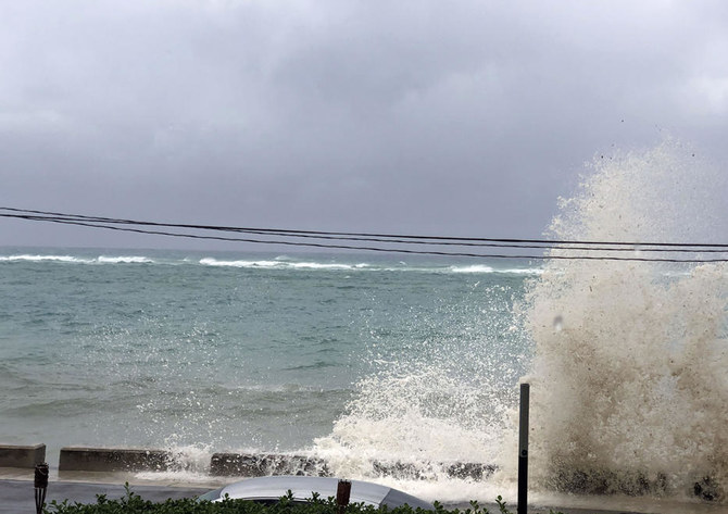
Ocean waves are seen during the approach of Hurricane Dorian on September 1, 2019 in Nassau, Bahamas. (AFP / Lucy Worboys)

The hurricane was approaching with maximum sustained winds of 297 kph and gusts up to 354 kph.

Dorian tied the record for the most powerful Atlantic hurricane ever to come ashore, the Labor Day hurricane of 1935.

Dorian slammed into Elbow Cay in Abaco island at 12:40 p.m., and then made a second landfall near Marsh Harbor at 2 p.m., after authorities made last-minute pleas for those in low-lying areas to evacuate.

The hurricane was approaching the eastern end of Grand Bahama island in the evening, forecasters said. With its maximum sustained winds of 185 mph (297 kph) and gusts up to 220 mph (354 kph), Dorian tied the record for the most powerful Atlantic hurricane ever to come to shore, equaling the Labor Day hurricane of 1935, before the storms were named.


Hurricane Dorian: US state coast evacuated as 220mph storm kills boy, seven

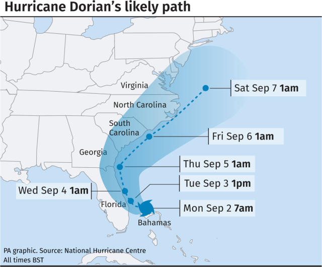
Hurricane Dorian's likely path across the US coast (Picture: PA)

Americans were preparing to evacuate their homes on Monday as Hurricane Dorian battered the Bahamas with winds of up to 220mph.

Authorities have evacuated people from the coasts of Georgia, North Carolina and South Carolina after the National Hurricane Center said water levels could rise as much as 23ft above typical levels due to storm surges.

Hurricane Dorian also turned fatal at the weekend when the Category 5 storm claimed the life of Lachino Mcintosh, seven, in the Bahamas.

He got in trouble while trying to escape the bad weather with his family near their home in Abaco, according to Bahamas press. His sister went missing in the storm, which is the worst the Bahamas has seen in recent history.

South Carolina Governor Henry McMaster ordered a mandatory evacuation of the entire coast of the state amid Dorian’s threat.

The order, which covers about 830,000 people, goes into effect at noon local time on Monday, when state troopers will begin reversing lanes so they all head inland on major coastal highways.

Georgia’s governor Brian Kemp also ordered a mandatory evacuation of the state’s Atlantic coast, also starting at noon on Monday.

Authorities in Florida ordered mandatory evacuations in some vulnerable coastal areas.

The storm’s top sustained winds decreased slightly to 170mph as its westward movement slowed on Sunday, crawling along Grand Bahama island early on Monday at 2mph in what forecasters said would be a day-long assault.


Hurricane Dorian: ‘It’s Going to be Extremely Close’ Says Hurricane Specialist
Hurricane Dorian’s winds have howled with gusts of up to 220 mph across the Caribbean, with sustained winds at 185 mph, making it the strongest storm to ever hover east of Florida, or that far north in the Atlantic Ocean, and tying it in second for highest winds ever recorded in the Atlantic.

The merciless storm hit the island of Great Abaco in the Bahamas with that force on Sunday, leaving total devastation. The landfall officially tied Dorian with the decades-old record held by the 1935 Labor Day hurricane for the strongest winds of any storm to hit land. The slowly encroaching Hurricane was moved to Category 5 on Sunday—the highest category on the Saffir–Simpson scale, which classifies hurricanes based off of sustained wind speed.

With just 205 miles between Dorian and the Florida coastline, President Trump made the declaration on Twitter on Sunday that 2019’s Labor Day storm “is looking like one of the largest hurricanes ever.” Later in the day, South Carolina Governor Henry McMaster (R) ordered a mandatory evacuation of the state’s entire coastline in the possibility that Dorian sweeps northward on Wednesday.


https://www.accuweather.com/en/weat...-the-northeastern-us-later-this-week/70009224
September 2, 2019 - "Dorian could behave similar to a wintertime nor'easter," Miller said.

Dorian NE Canada 11 am


"The rain shield with Dorian may generally impact areas along and east of the I-95 corridor," Miller said.

Locations from Norfolk, Virginia; Dover, Delaware; Atlantic City, New Jersey; Islip, New York; and Plymouth, Massachusetts, are some of the cities that could face a 12- to 24-hour period of soaking rain and gusty winds.

Following its arrival across the Northeast, parts of Atlantic Canada could be next in line with rain and wind from Dorian.


Hurricane Dorian lashes Bahamas, menaces east US coast
1737906-1873168933.jpg

1 / 5
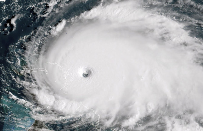
This satellite image obtained from NOAA/RAMMB, shows Tropical Storm Dorian as it approaches the Bahamas at 13:40 UTC on September 1, 2019. (AFP)

September 02, 2019 - Titusville, Florida: Hurricane Dorian battered the Bahamas early on Monday, peeling off roofs, toppling cars and snapping power lines as rising floodwater threatened to engulf houses.

The second-strongest Atlantic storm on record was forecast to pound the archipelago through the day, then move slowly toward the east US coast, where authorities ordered more than a million people evacuated in Florida, South Carolina and Georgia.

There were no immediate estimates of casualties as the category five storm covered the northwestern islands of Great Abaco and Grand Bahama with twisted metal and splintered wood.

Winds gusting up to 200 mph (320 kph) destroyed or damaged more than 13,000 homes, the International Federation of Red Cross and Red Crescent Societies said.
 
Storm update: Just went out on errands. Most places appear to be open for business, but a lot of streets are heavily flooded, which is not unusual here with any kind of heavy rain. No wind. Area airports still open. I noticed that the private boats are suddenly mostly gone now, I suppose dry docked or moved elsewhere.
 
Geeze, when you are on an island and a hurricane is practically on top of you, how do you evacuate? And to where?
You can't, not really. Plus these paths are not predictable as far as deciding where to run to. Ocean front isn't safe. You can get highest possible elevation and construction that is way above code, like monolithic dome maybe. But the ocean is powerful, even in normal circumstances. Humbling.
 

Trending content

Back
Top Bottom