You are using an out of date browser. It may not display this or other websites correctly.
You should upgrade or use an alternative browser.
You should upgrade or use an alternative browser.
Crazy Storm Weather and Lightning - Global
- Thread starter mabar
- Start date
Storm Naida over Germany:
Flooding in Hamburg
Northern Germany was hit by strong winds and a tidal surge overnight into Sunday as storm Nadia moved in, severely restricting rail and road travel.
In Dagebuell on the North Sea coast, the storm surge hit particularly hard, drawing in a crowd of onlookers.
The storm system, which is known as Nadia in Germany and Malik in other countries, has severely affected northern Europe over the weekend and is now moving eastward.
Flooding in Hamburg
Storm tide hits Germany's North Sea coast
Updated: 30/01/2022Northern Germany was hit by strong winds and a tidal surge overnight into Sunday as storm Nadia moved in, severely restricting rail and road travel.
In Dagebuell on the North Sea coast, the storm surge hit particularly hard, drawing in a crowd of onlookers.
The storm system, which is known as Nadia in Germany and Malik in other countries, has severely affected northern Europe over the weekend and is now moving eastward.
At least two dead in Germany by the hurricane storm ‘Nadia’
Flooding in Hamburg, rail and road outages and suspension of ferries in the North Sea and the Baltic
At least two people have died, railway lines and roads have been cut and the city of Hamburg has suffered flooding due to the effects of the hurricane storm ‘Nadia’ that broke out last night in northern Germany and is still affecting other large cities, such as Berlin, where firefighters have dictated a state of emergency. A person died late on Saturday in the town of Beelitz, in Brandenburg and north of the German capital, after being hit by an advertising poster that was ripped off by the wind. In Bremen a pedestrian died when he was hit by a tree that the storm felled. In Berlin, hurricane winds of more than 100 km/h caused several accidents on the urban train lines without causing any casualties, although numerous convoys are stopped due to the obstruction of the tracks and the breakage of catenaries caused by fallen trees.
In Hamburg, much of the port district of St. Pauli is flooded when the Elbe River overflowed its banks last night due to the entry of strong sea currents at high tide. Local authorities warned of a second wave of flooding at noon to coincide with the new tide. The Federal Office of the Navy reported that the water level of the Elbe in Hamburg would be 2.5 to 3 meters higher than normal. The police have asked citizens to avoid approaching places where the waters have already caused flooding such as the port and the popular local fish market. In Hamburg alone, the police attended 300 rescue missions, while the firefighters carried out more than 450 operations.
30 kilometers off the coast of East Frisia, in the northern state of Schleswig-Holstein, a cargo ship drifted for several hours in the middle of the storm due to the difficulties of the crew to gain control of the ship. In Hamburg, another ship was blocked under a bridge carried by the current of the floods. There is a serious danger of flooding along the entire German North Sea coast. In the coastal region between the Weser and Elbe rivers, the sea waters have exceeded 2.5 meters above normal. The hurricane storm “Nadia” also affects southern Germany, where alarms have been activated in regions such as the Bavarian Forest and the Alps.
Meanwhile, rail traffic has collapsed in several regions in northern and northeastern Germany. Between Stralsund and Binz, on the country’s Baltic coast, the communications of the ICE high-speed trains have been suspended and between Bremen and Hamburg there are significant delays in schedules due to the fact that one of the sections of the double track is cut . Also between Rostock and Berlin and Hamburg and Berlin lines have been suspended and there are enormous delays. Deutsche Bahn, the largest German railway company, advises its users to find out about the status of their reservations before going to the stations. The storm has also forced the suspension of the operation of the ferries that connect the continent with the different Frisian Islands in the North Sea, but also in the Baltic the “ferry” between Rostock and the Danish port of Gedser and the island of Falster in That country.
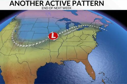
Round 2 brings another challenging week with polar temperatures dipping into the mid-west and the east coast.
As the Texas Grid gets another trial facing an extremely cooler forcast.
And in the European Theater (from the Met), recovery begins from Storms Malik and Corrie as Scotland ready's for more extreme winds.
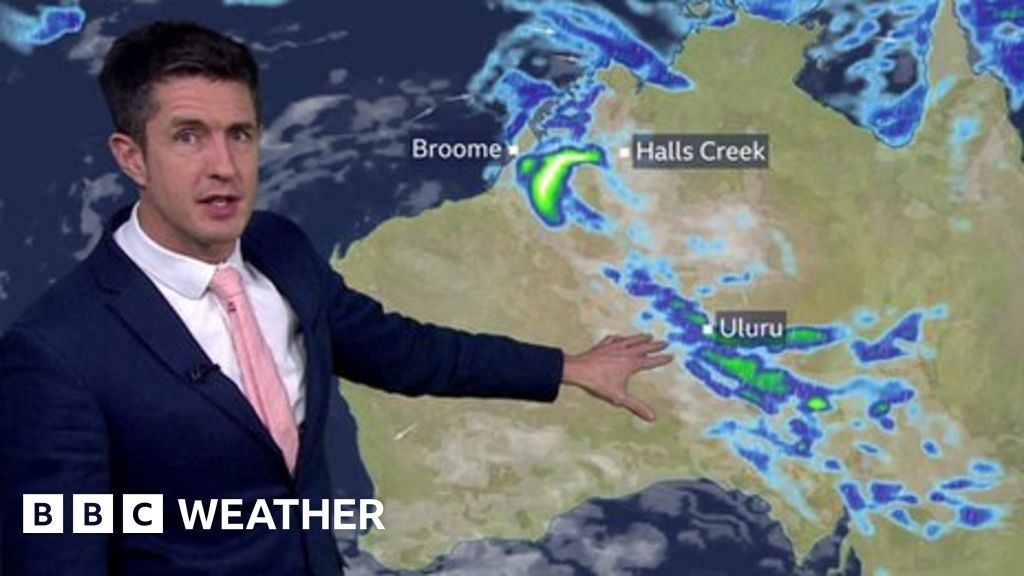
Also from the land Downunder "Western Australia braces for torrential rain"
 www.bbc.com


 www.weathernationtv.com

As the Texas Grid gets another trial facing an extremely cooler forcast.
And in the European Theater (from the Met), recovery begins from Storms Malik and Corrie as Scotland ready's for more extreme winds.
Also from the land Downunder "Western Australia braces for torrential rain"

Western Australia braces for torrential rain
A slow-moving tropical low will bring flooding rain to parts of the country. Chris Fawkes has more
Major Winter Storm to Impact Oklahoma & Texas

Pacific Northwest - Mountain Snow and Coastal Rain
The Pacific Northwest has been quiet for the last week or so, but rain has returned this Sunday as a low pressure system pushes onshore. The dip in the jet s
 www.weathernationtv.com
Megaflashes! New records set for longest lightning strikes, both in length and duration
Story Summary
- The new record for longest lightning strike is now 477 miles, set on April 29, 2020.
- The new record for longest-duration lightning strike is just over 17 seconds.
- “These are extraordinary records from single lightning-flash events."
The new record for the longest lightning strike is now 477 miles, set on April 29, 2020, across parts of the southern United States from Texas to Mississippi, according to the report.
And the new record for longest-duration lightning strike is just over 17 seconds, which came from a flash that developed continuously through a thunderstorm over Uruguay and northern Argentina on June 18, 2020.
“These are extraordinary records from single lightning-flash events," said Professor Randall Cerveny, rapporteur of Weather and Climate Extremes for the World Meteorological Organization (WMO), which certified the records.
World weather records can take years to officially certify.
"Environmental extremes are living measurements of the power of nature, as well as scientific progress in being able to make such assessments," Cerveny said. "It is likely that even greater extremes still exist, and that we will be able to observe them as lightning detection technology improves.”
The findings were published in the Bulletin of the American Meteorological Society.
“Lightning is a major hazard that claims many lives every year," WMO Secretary-General Professor Petteri Taalas said. "The findings highlight important public lightning safety concerns for electrified clouds where flashes can travel extremely large distances.”
The records were determined with help from lightning detection equipment onboard satellites in orbit around the Earth.
The WMO said the new record strikes occurred in hotspots for "mesoscale convective system" thunderstorms, in which extraordinary megaflashes can occur – namely, the Great Plains of North America and the La Plata basin in South America.
A megaflash is defined as a horizontal lightning discharge that reaches hundreds of miles in length.
"These extremely large and long-duration lightning events were not isolated but happened during active thunderstorms. Any time there is thunder heard it is time to reach a lightning-safe place,” lightning specialist and WMO committee member Ron Holle said.
In 2021, the U.S. saw a record low number of lightning deaths: Only 11 recorded, according to the National Lightning Safety Council.
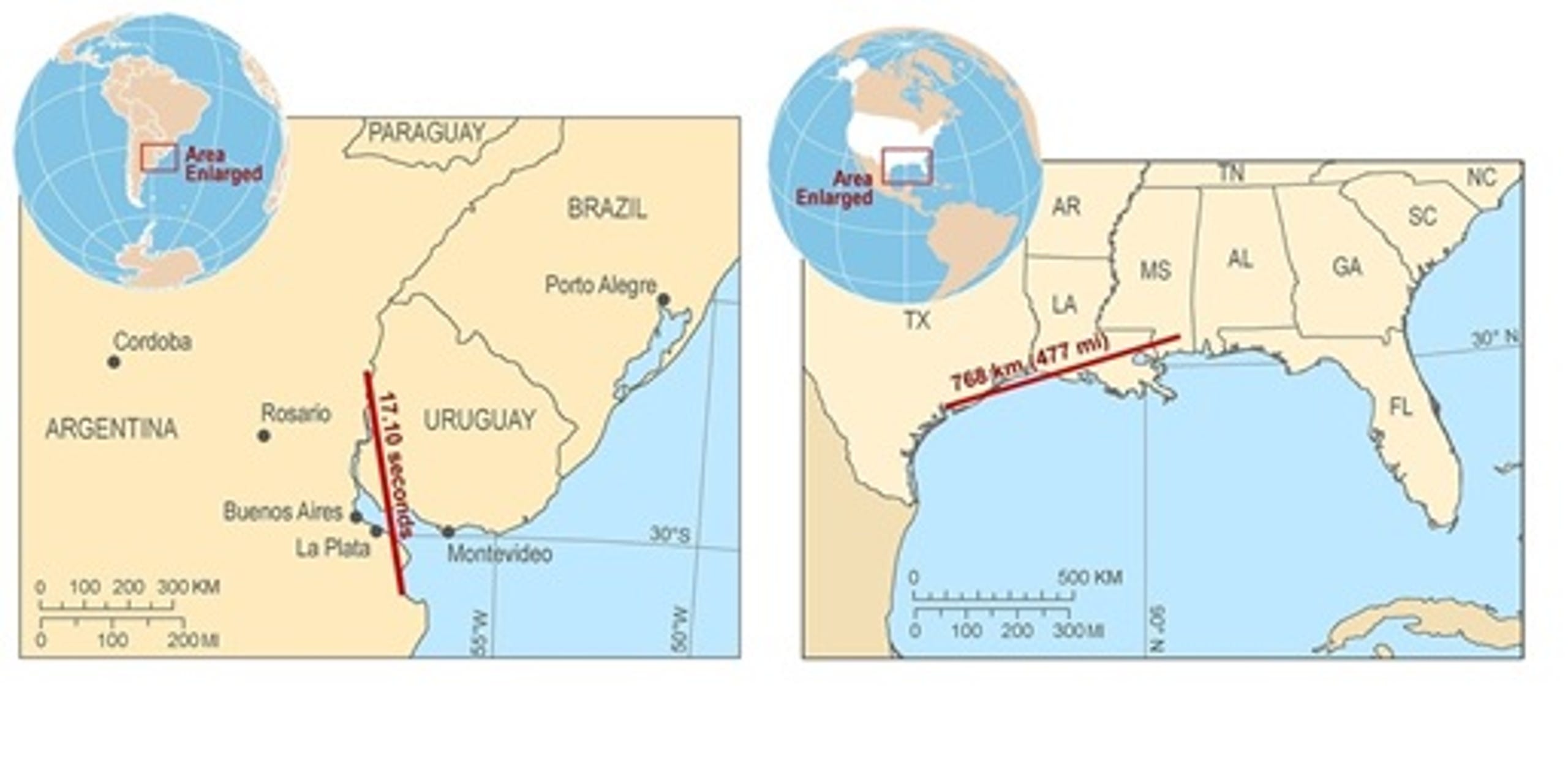
New records were set for both the duration of a lightning strike (left, in South America) and for length of a lightning strikes (right, in the U.S.) / WORLD METEOROLOGICAL ORGANIZATION
The incredible twist and turns of the Jet stream.
Strong #Lluvias are forecast in #Tamaulipas and #Chubascos in nine other entities of #México , during the next few hours
More information in https://smn.conagua.gob.mx/files/pdfs/comunicados-de-prensa/Comunicado0098-22.pdf
 www.zerohedge.com
Strong #Lluvias are forecast in #Tamaulipas and #Chubascos in nine other entities of #México , during the next few hours
More information in
ZeroHedge
ZeroHedge - On a long enough timeline, the survival rate for everyone drops to zero
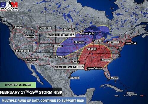
A private weather forecaster BAMWX are monitoring weather models that suggest a change in the jet stream will create cooler weather for the central part of the country and, by the end of next week, set up the possibility for the next "big storm."
"A big storm one week from today [Thursday] continues to show itself on all global weather data," according to Kirk Hinz, the chief meteorologist at BAMWX. The timing of the storm, remember, nothing is locked in, is between Feb. 17-19 for areas of the central US, including Northern Texas to Omaha to Minneapolis to Chicago. He noted there could be "a severe side to this along with a wide side."
There are still many unknowns about the storm a week out, but Hinz has produced a storm risk threat map that gives readers a general idea of where the storm may strike late next week.
It appears a new jet stream configuration this weekend could pave the way for the storm. In recent days, the southern Plains and Rockies and even Southern California experienced abnormally warm temperatures.
The latest round of warmer weather in the central and western part of the US resulted in declining heating demand which sent US natural gas futures tumbling this week, the most significant weekly drop this year.
BAMWX meteorologists will continue to monitor weather models as they change, and a more accurate threat map will be produced in the days.
#Tempête #Eunice Friday: trajectory modeled today. This depression will deepen rapidly before crossing the British Isles. We then speak of a "weather bomb". The north-west of France, on the edge, would be affected by stormy winds along the English Channel
Several #tempêtes over the next few days over northwestern Europe, developing on either side of a straight jet rapid over the North Atlantic. The MetOffice has already christened #StormDudley and #StormEunice . Animation Arpege Meteo France.
Heavy hail hit a part of northern Dalmatia, a huge watersprout was photographed near Pag
According to the network of stations, 61 liters of rain per square meter fell in Starigrad Paklenica, of which a significant part was hail. The hail covered the whole area, which caused temporary problems on some roads.
In nearby town Seline, the height of the hail sometimes exceeded 5 centimeters, and there were significant hailstorms in other parts of Zadar County.
Yesterday in the late afternoon on the sea between islands Pag and Lošinj, a large watersprout was formed, and it was filmed by the famous storm hunter and photographer Danijel Palčić.
**********************
In Germany, a huge storm is expected tomorrow, 17.2.:
School is canceled throughout NRW on Thursday

Wegen Sturms: Schule fällt am Donnerstag in ganz NRW aus
Das Schulministerium in NRW hat für morgen (Donnerstag, 17. Februar) angeordnet, dass im ganzen Land der Unterricht ausfällt. Laut Mitteilung des Deutschen Wetterdienstes und des Landeslagezentrums von heute werden für den morgigen 17.
The Ministry of Education in North Rhine-Westphalia has ordered tomorrow (Thursday, January 17) that classes will be canceled across the country.
According to a statement from the German Weather Service and the State Situation Center today, widespread storms and heavy gusts of wind are expected for the whole of North Rhine-Westphalia for tomorrow, February 17, 2022, with hurricane gusts in some areas at high altitudes.
Based on the decree "Regulations on the cancellation of lessons and other school measures in the event of storms and other extreme weather events", the Ministry of Schools and Education is therefore ordering a nationwide cancellation of lessons for tomorrow, February 17, 2022.
Mudslides and floods kill at least 38 people after 26cm (10 inches) of rain falls in just 3 hours on the city of Petropolis, Brazil

 www.sott.net
----------------------------------------------------------------------------------------
Extract -
Brazil mudslides from torrential rains kill at least 38
Local authorities say the death toll from mudslides and floods that swept through a mountainous region of Rio de Janeiro state has reached 38
Residents and volunteers remove the body of a landslide victim in Petropolis, Brazil, Wednesday, Feb. 16, 2022.
The death toll from devastating mudslides and floods that swept through a mountainous region of Rio de Janeiro state has reached 38, local authorities said Wednesday.
The city of Petropolis was slammed by a deluge on Tuesday, and Mayor Rubens Bomtempo said the number of dead could rise as searchers picked through the wreckage.
Rosilene Virgilio, 49, was in tears as she recalled the pleas for help from a woman she couldn't save.
"Yesterday there was a woman screaming, 'Help! Get me out of here!' But we couldn't do anything; the water was gushing out, the mud was gushing out," Virgilio told The Associated Press. "Our city unfortunately is finished."
Petropolis is a German-influenced city named for former emperor Dom Pedro I. Nestled in the mountains above the coastal metropolis, for almost two centuries it has been a refuge for people escaping summer heat and tourists keen to explore Brazil's "Imperial City." It features stately mansions along its waterways, but its mountainsides are covered with homes packed tightly together, some of which lack proper foundations.
Gov. Claudio Castro said that he was mustering all the state government's heavy machinery to help dig out the buried area. He told journalists that soldiers were already working in the stricken region, which saw almost more than 900 deaths from heavy rainfall in January 2011.
The state fire department said late Tuesday the area got 25.8 centimeters (just over 10 inches) of rain within three hours Tuesday -- almost as much as during the previous 30 days combined.
Video posted on social media showed cars and houses being dragged away by landslides, and water swirling through Petropolis and neighboring districts. The Globo television network showed houses buried beneath mud in areas firefighters hadn't yet been able to access.
Several streets remained inaccessible Wednesday as cars and household goods piled up, blocking access to higher parts of the city.
"The neighbors came down running and I gave them shelter," bar owner Emerson Torre, 39, recalled.
But under torrents of water, his roof collapsed. He managed to get his mother and three other people out of the bar in time, but one neighbor and the person's daughter were unable to escape.
"It was like an avalanche, it fell all at once. I've never seen anything like it," Torre told the AP as rescue helicopters hovered overhead. "Every neighbor has lost a loved one, has lost two, three, four members of the same family, kids."
Petropolis' city hall declared three days of mourning. Brazil's President Jair Bolsonaro, who is on a trip to Russia, said on Twitter that he instructed his ministers to deliver immediate support to the afflicted.
"May God comfort the family members of the victims," he wrote.
Southeastern Brazil has been punished with heavy rains since the start of the year, with more than 40 deaths recorded between incidents in Minas Gerais state in early January and Sao Paulo state later the same month.

Mudslides and floods kill at least 152 after 10 inches of rain in just 3 hours in the city of Petropolis, Brazil (UPDATES)
At least 18 people have died in mudslides and floods after a mountainous region of Rio de Janeiro saw almost a month's worth of rain fall in just three hours. The state fire department said more than 180 soldiers were involved in a rescue mission...
----------------------------------------------------------------------------------------
Extract -
Brazil mudslides from torrential rains kill at least 38
Local authorities say the death toll from mudslides and floods that swept through a mountainous region of Rio de Janeiro state has reached 38
Residents and volunteers remove the body of a landslide victim in Petropolis, Brazil, Wednesday, Feb. 16, 2022.
The death toll from devastating mudslides and floods that swept through a mountainous region of Rio de Janeiro state has reached 38, local authorities said Wednesday.
The city of Petropolis was slammed by a deluge on Tuesday, and Mayor Rubens Bomtempo said the number of dead could rise as searchers picked through the wreckage.
Rosilene Virgilio, 49, was in tears as she recalled the pleas for help from a woman she couldn't save.
"Yesterday there was a woman screaming, 'Help! Get me out of here!' But we couldn't do anything; the water was gushing out, the mud was gushing out," Virgilio told The Associated Press. "Our city unfortunately is finished."
Petropolis is a German-influenced city named for former emperor Dom Pedro I. Nestled in the mountains above the coastal metropolis, for almost two centuries it has been a refuge for people escaping summer heat and tourists keen to explore Brazil's "Imperial City." It features stately mansions along its waterways, but its mountainsides are covered with homes packed tightly together, some of which lack proper foundations.
Gov. Claudio Castro said that he was mustering all the state government's heavy machinery to help dig out the buried area. He told journalists that soldiers were already working in the stricken region, which saw almost more than 900 deaths from heavy rainfall in January 2011.
The state fire department said late Tuesday the area got 25.8 centimeters (just over 10 inches) of rain within three hours Tuesday -- almost as much as during the previous 30 days combined.
Video posted on social media showed cars and houses being dragged away by landslides, and water swirling through Petropolis and neighboring districts. The Globo television network showed houses buried beneath mud in areas firefighters hadn't yet been able to access.
Several streets remained inaccessible Wednesday as cars and household goods piled up, blocking access to higher parts of the city.
"The neighbors came down running and I gave them shelter," bar owner Emerson Torre, 39, recalled.
But under torrents of water, his roof collapsed. He managed to get his mother and three other people out of the bar in time, but one neighbor and the person's daughter were unable to escape.
"It was like an avalanche, it fell all at once. I've never seen anything like it," Torre told the AP as rescue helicopters hovered overhead. "Every neighbor has lost a loved one, has lost two, three, four members of the same family, kids."
Petropolis' city hall declared three days of mourning. Brazil's President Jair Bolsonaro, who is on a trip to Russia, said on Twitter that he instructed his ministers to deliver immediate support to the afflicted.
"May God comfort the family members of the victims," he wrote.
Southeastern Brazil has been punished with heavy rains since the start of the year, with more than 40 deaths recorded between incidents in Minas Gerais state in early January and Sao Paulo state later the same month.
Storm Eunice moves through England and Northern Europe within the next 24 hours.
The storm #Eunice which will hit the British Isles hard on Friday can be described as a meteorological bomb.

 Here's why

 https://actualite.lachainemeteo.com/actualite-meteo/2022-02-16/tempete-eunice-pourquoi-parle-t-on-de-bombe-meteorologique-62504…
The storm #Eunice which will hit the British Isles hard on Friday can be described as a meteorological bomb.
The prominent line in the northern half can be seen in the simulated rain radar from Thu 00:00 to Thu 07:00. Heavy showers/thunderstorms with local hurricanes and even a risk of tornadoes! This map is already impressive, especially BRB/Berlin at around 4 https://kachelmannwetter.com/de/modellkarten/sui-hd/2022021600/deutschland/signifikantes-wetter-erweitert/20220217-0300z.html… /FR
https://twitter.com/ReedTimmerAccu/status/1494390452698722319
Storms wreak havoc across Germany
High winds and stormy weather have been causing havoc in Germany, especially the north of the country. Here's a look at some photos and videos.
Published: 17 February 2022 15:40 CET

A boat on the river Elbe in Hamburg. Photo: picture alliance/dpa | Daniel Bockwoldt
Germany was hit by severe winds and rain on Wednesday night and Thursday due to Storm Ylenia – and more storms were expected on Friday.
Flights were grounded, train travel came to a standstill in some regions and schools in several states had to close.
In Hamburg, the video below of one of the city’s HADAG ferries called ‘Tollerort’ shows how rough the river Elbe was on Thursday morning. The waves break the windscreen and fill the inside of the ferry.
According to HADAG Managing Director Tobias Haack, the accident happened on Thursday morning on line 68 from Teufelsbrück on the way to the jetty of the Airbus plant. Haack said no one was seriously injured and passengers were able to leave the ferry on foot.
“It was an incident that we have never had before,” Haack said.
Choppy water was seen in many parts of the country, including Tegeler See (lake), in the north of Berlin. Photo: DPA/Jörg Carstensen
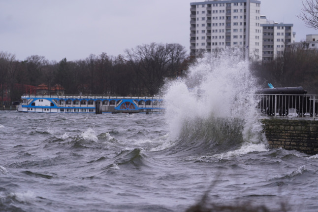
Another dramatic video from Hamburg filmed early on Thursday morning.
A portaloo blown over on the side of the road in Mühlen Eichsen, Mecklenburg-Western Pomerania. Photo: DPA/Jens Büttner
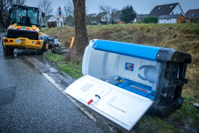
Near Hamburg 150 km/h wind gusts!
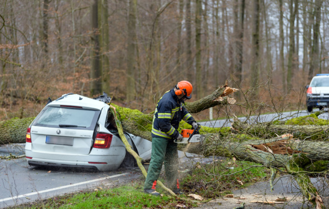
A tree lies in a car in Bad Bevensen, Lower Saxony. Photo: DPA/Philipp Schulze
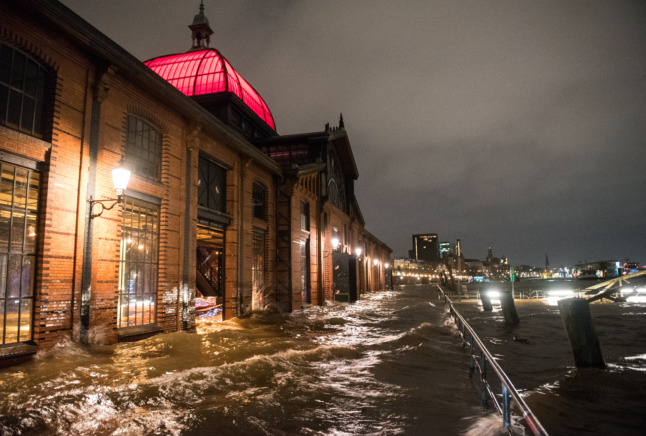
Hamburg’s famous fish marked flooded on Thursday morning during a storm surge from the river Elbe. Photo: DPA/Daniel Bockwoldt
Berlin was also hit by extreme winds. Here, a pedestrian wrestles with an umbrella in the capital. Photo: DPA/Wolfgang Kumm

A sign at Petersdorf station in Brandenburg alerts travellers of disruption to transport due to the storm. Photo: DPA/Patrick Pleul

An overturned lorry in Lower Saxony. Luckily, the driver was not injured. Photo: DPA/Mohssen Assanimoghaddam
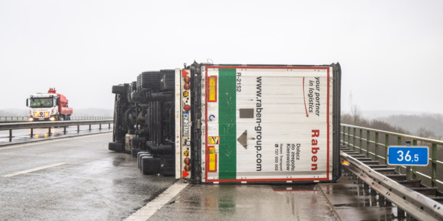
*****************************
Storms kill four and bring 'major travel disruptions' across northern Europe
Violent storms have killed four people and caused travel chaos across Britain, Germany, and the Netherlands.
Two people died in Germany after trees fell on their cars, while two others were killed in Poland when strong winds brought down a construction crane.
Tens of thousands of Europeans have been left without electricity after power lines were downed.
Meteorologists have warned that northern Europe could be battered by a series of storms over the coming days.
No long-distance trains were running in northern Germany before midday on Thursday, the railway operator Deutsche Bahn said as Storm Ylenia swept through the regions of Hesse, Saxony and southern Brandenburg.
Deutsche Bahn spokesman Achim Stauss said there was “considerable” damage to tracks and power lines.
Cancellations and delays are also expected in regional traffic.
Airports have also cancelled many flights due to the strong wind, including Berlin-Brandenburg Airport and Germany's largest airport in Frankfurt. Flights at Hamburg and Amsterdam’s Schiphol Airport were also cancelled.
German ferry services have also been temporarily suspended in many places, such as Lübeck and Rostock.
At the height of the storm, winds of up to 152 kilometres per hour occurred on Wednesday on the Brocken, the highest point of the Harz mountains in northern Germany.
About 54,000 households were left without electricity during the night in North Rhine-Westphalia, while in Bavaria about 10,000 people were affected by power cuts, according to operators. The outages were often caused by trees falling on power lines. In most cases, the power supply was quickly restored.
The Berlin fire brigade declared a state of emergency for the second time on Thursday morning as it was called to more than 100 operations, primarily to deal with fallen trees and branches. No injuries were reported.
In neighbouring Czech Republic, more than 300,000 households were without electricity on Thursday due to damaged power lines.
Trains were also cancelled in Scotland on Wednesday night because of Storm Dudley, which brought winds of up to 81 miles per hour (130 kph), according to Britain's Met Office.
Network Rail said that the storm had "caused major disruption" and warned that Storm Eunice "will be more severe" on Friday.
Some 19,000 households and businesses were also temporarily deprived of electricity across northern England.
The Met Office has placed most of England under amber weather warning for Friday due to Storm Eunice with coastal areas in south-west England and southern Wales in red warning forecasting "significant disruption and dangerous conditions due to extremely strong winds."
Train, bus and ferry services and flights in these areas concerned are to be cancelled with some power lines expected to be brought down.
A yellow warning for Northern Ireland and Scotland has also been decreed.
***************
Apparantely there was also a tornado in Krakow
Correction:Near Hamburg 150 km/h wind gusts!
This tweet from the German Meteorological Service shows high wind speeds during the night from Wednesday to Thursday. According to DWD, the highest wind speeds were recorded in Brocken, the highest point in the Harz Mountains, with speeds of up to 152 kilometers (94 miles) per hour.
Not all hurricanes are the same. Especially not in Europe. In Germany - says Berlin's BZ newspaper it's cyclone Zeynep. Because: Berlin's Free University has been giving these names to low- and high-pressure areas for decades. In Britain it is Eunice that causes fear and terror while the Scandinavians call it Nora.
by Peter Amenda, B.Z.
"These names are also used by the Central European Group of EU weather services, but there was a problem this year because now not only additionally the Western European group, but also the Northern European group have each assigned their own names. Zeynep, Eunice (Western Europe), Nora (Northern Europe). A completely unnecessary action by the EU weather services," says Petra Gebauer of the Institute of Meteorology at FU Berlin.
"This is already a mess. Nobody talks to each other there. In Germany we have our fixed lists and always assign names to each high and low. The other countries don't do that. The British only give names if the storm is dangerous and special," says meteorologist Dominik Jung.
"There is a huge problem as each language area will soon have its own low and high names. This can also lead to major problems, especially possible confusion with many lows like this series," said climatologist Dr. Karsten Brandt of donnerwetter.de to BILD.
In addition, there are studies that show that, for example, female names (for hurricanes) are taken less seriously than male names and there are more victims because of this alone, says weather expert Brandt. Using only male names for hurricanes would not be fair, but actually reasonable.
Insane extreme weather numbers across the planet as the world transfixes with the White House exacerbating the Russian news with ly's.
If we are to believe the readings from the Seaford Newhaven buoy, the maximum wave height recorded at 1:30 p.m. reached more than 31m When passing a low pressure trough like #Eunice , the maximum wave height can indeed be 2.5x+ higher than the significant height.

An enormous storm system tore across the central and eastern states from Thursday into Friday, leaving snowfall records, severe weather damage, messy traffic conditions and flood threats in its wake.
The major winter storm first made its presence felt along the West Coast earlier this week when it brought snow and hail to areas outside of Los Angeles days after the city saw a high of 86 degrees Fahrenheit in the midst of a winter heat wave.
High wind advisories stretching from Texas to Maine, spanning a distance of more than 1,900 miles, heralded the storm's approach. A battle between warm and cold air sparked severe thunderstorms from Oklahoma to Alabama to Kentucky and delivered a mix of strong winds, hail and tornadoes.
The National Weather Service (NWS) Storm Prediction Center recorded at least four preliminary tornado reports across Alabama, including in Jefferson, Shelby, Fayette, and Tuscaloosa counties. Hail with a diameter of up to 1 inch was also reported. No fatalities were reported, but a mobile home in Leeds, Alabama, was damaged after a possible tornado, according to The Associated Press.
By Friday morning, Pennsylvania was dealing with a considerable number of power outages as at least 60,000 customers were without power, according to PowerOutage.US. The majority of power outages were confined to the mid-Atlantic and Northeast.
Some of the strongest wind gusts on Thursday were recorded across Oklahoma, Tennessee and Mississippi, with Wears Valley, Tennessee, a small town in the eastern part of the state near the border with North Carolina, recording a gust of up to 78 mph.
Across the Midwest, it didn't take long for snow to begin piling up where the air was the coldest. Snow rates of 1-2 inches per hour were recorded in Kansas City, Missouri, early Thursday, blanketing roadways and snarling the morning commute.

By noon, Kansas City was reporting record-breaking snowfall totals. The National Weather Service office in the city measured 6.4 inches of snow by midday Thursday, setting a new daily snowfall record. The city ended up with a total of 7 inches for the day. The previous record in Kansas City for Feb. 17 dated back to 1893, the same year Grover Cleveland was sworn in as the 24th U.S. president when 6.0 inches of snow fell. Other reports from trained weather spotters around the Kansas City area indicated as much as 9.3 inches of snow accumulated on Thursday.
Locations in Kansas such as De Soto, Eudora, Williamstown and Shawnee saw around 10 inches of snowfall throughout Thursday. The snow and cold was a jarring case of weather whiplash for many places across Kansas, which just a day earlier experience temperatures in the mid- to upper 60s.
At least a foot of snow was recorded in Manito, Illinois, while Springfield, Illinois, received 5.2 inches of snow, breaking a daily record of 3 inches that also dated back to 1893.
People walk on a snowy street in Kansas City, Mo., as a winter storm passes through the region Thursday, Feb. 17, 2022. (AP Photo/Charlie Riedel)
The snow wasn't without any hazards, however, with the snow-covered roads creating dangerous travel conditions. At least two Kansas Highway Patrol (KHP) troopers were struck on Thursday while out on the road. Both were reported not to have been injured, but the incidents highlighted the need for caution on the roads, and the KHP warned people to stay at home if possible.
Farther northeast, Illinois State Police were on the scene of a multi-vehicle crash on I-39 southbound near mile marker 14 at El Paso. The crash was reported to be several hundred yards long and involved around 100 vehicles, according to The Associated Press. El Paso is located a little over two hours to the southwest of Chicago.
There were significant disruptions to air travel from the cross-country storm as well.
More than 600 flights arriving to and departing from Chicago's O'Hare and Midway airports were canceled Thursday, with at least another 283 canceled at Detroit Metro Wayne County Airport, according to FlightAware.

Time-lapse of Interstate 65 after a multi-vehicle pileup closed parts of the interstate.
More than 600 flights arriving to and departing from Chicago's O'Hare and Midway airports were canceled Thursday, with at least another 283 canceled at Detroit Metro Wayne County Airport, according to FlightAware.
A state over, a multi-vehicle pileup amid snowy conditions forced the closure of Interstate 65 southbound near Southeast Grove, Indiana, located about 50 miles to the southeast of Chicago. Footage from traffic cameras showed trucks and vehicles at a standstill on a snow-packed highway, and a person on Twitter who claimed to be a truck driver stuck in the mess of traffic said that it was "a repeat of I-95 in Virginia," referring to the traffic backup on the interstate that lasted for more than 24 hours after a snowstorm hit the mid-Atlantic hard in early January.
Temperatures also came crashing down in the central part of the country. Little Rock, Arkansas, had a high of 72 on Thursday, but temperatures were in the upper 20s there early Friday. Memphis, Tennessee, fell just short of hitting 70 Thursday but had a morning temperature of 27 on Friday.
The NWS issued at least two flash flood warnings Thursday associated with ice jams in Ohio and Illinois, respectively. There were multiple high water and swift water rescues in the city of Vermilion, Ohio, according to a tweet from the NWS office in Cleveland.
The Vermilion River peaked at 15.82 feet Thursday afternoon, though it began to drop later in the day. This total came just short of the all-time record of 17.1 feet, which was recorded in 1969, according to the NWS Advanced Hydrologic Prediction Service.
If we are to believe the readings from the Seaford Newhaven buoy, the maximum wave height recorded at 1:30 p.m. reached more than 31m
Trending content
-
-
Thread 'Coronavirus Pandemic: Apocalypse Now! Or exaggerated scare story?'
- wanderingthomas
Replies: 30K -
-

