No Cthulhu but a tornado caught at night in Sahama, Oman
You are using an out of date browser. It may not display this or other websites correctly.
You should upgrade or use an alternative browser.
You should upgrade or use an alternative browser.
Crazy Storm Weather and Lightning - Global
- Thread starter mabar
- Start date
Heavy rains cause massive flooding in Oman
Sorry i can't translate where is it.
November 30
November 30
michaelrc
Dagobah Resident
"Mass Casualty" Incident In Illinois; Kentucky Governor Fears 50 Dead As Major Storms Rip Through Multiple US States
“This tornado event may surpass the one in 1974 … as one of the most deadliest in Kentucky’s history,” Dossett said, adding that this will be “one of the darkest days in the state’s history.”
The primary tornado was on the ground for 200-miles, Beshear said and would be the longest traveled of any tornado in the state for nearly 100 years.
Mayfield Kentucky
michaelrc
Dagobah Resident
"Mass Casualty" Incident In Illinois; Kentucky Governor Fears 50 Dead As Major Storms Rip Through Multiple US States
“This tornado event may surpass the one in 1974 … as one of the most deadliest in Kentucky’s history,” Dossett said, adding that this will be “one of the darkest days in the state’s history.”
The primary tornado was on the ground for 200-miles, Beshear said and would be the longest traveled of any tornado in the state for nearly 100 years.
Mayfield Kentucky
View attachment 52355View attachment 52356View attachment 52357View attachment 52358
ZeroHedge
ZeroHedge - On a long enough timeline, the survival rate for everyone drops to zero
Jtucker
Jedi Master
Very unusual that a December tornado lasts that long for such a long distance. Late night tornado strikes are the most deadly. Although I disagree with some of the space weather guys about the cause of this "weather compacting", it does seem to be happening. Reading Pierre's books definitely explains the cause as "grounding" of the magnetosphere by Nemesis.ZeroHedge
ZeroHedge - On a long enough timeline, the survival rate for everyone drops to zerowww.zerohedge.com
There does seem to be an inability of the magnetosphere to disperse solar and cosmic inputs in the way it has for the past decades. Everything seems to compact and "dig in" much more than it has - at least in my 50+ years of living in North America. First BC and its infrastructure destruction, and now KY gets hit hard. Some of the interesting repeating patterns that pop up is the New Madrid earthquake zone being less that 80 miles from Mayfield where the Tornado hit.
I was really fascinated by the research Laura did on the Bell Witch and how the C's said that after the New Madrid earthquake happened that the EM energies were unsettled and allowed the curtain to be breached by 4th Density entities.
If you connect the dots in that area, high strangeness has always been going on. Paulides', "Wildman" book has numerous articles from pre-1910 about posses forming in Western Tennessee and Eastern Tennessee hunting down "Wildmen" who snatch kids in the area. There was an odd series of books called "Foxfire" which were sort of this hippie-esque back to the land Appalachia that instead of skewing "Free Love", it went hard back to "Hillbilly" herbs and Christianity mixed with old mountain values. One of the most fascinating stories seems to recount a Wildman/Sasquatch picked up as a hitchhiker SW Tennessee.
My feeling would be that this area around the New Madrid earthquake zone will be one to watch. The Bell Witch is the weirdest by far - but even the Franklin Kentucky "goblin shootout" is close to the area as is the Mantell UFO dogfight. Window Areas, in my guess.
Super-Typhoon Rai Explodes to Cat 5.
Typhoon Odette (Rai) continued to strengthen over the Philippine Sea while moving toward the Caraga region in Mindanao before dawn on Thursday, December 16.
Odette now has maximum sustained winds of 150 kilometers per hour from the previous 140 km/h, and gustiness of up to 185 km/h from the previous 170 km/h, said the Philippine Atmospheric, Geophysical, and Astronomical Services Administration (PAGASA) in its 5 am bulletin
Typhoon Odette intensifies again as it heads for Dinagat-Surigao area
Last edited:
RESEARCHERS IDENTIFY NEW METEOROLOGICAL PHENOMENON DUBBED “ATMOSPHERIC LAKES”
LIKE ATMOSPHERIC RIVERS, BUT SMALLER AND SLOWER MOVING, THE POOLS OF WATER VAPOR BRING MUCH-NEEDED RAIN FROM THE INDO-PACIFIC TO ARID REGIONS ALONG THE EAST AFRICAN COAST
NEW ORLEANS—A new meteorological phenomenon has been identified drifting slowly over the western Indian Ocean. Dubbed “atmospheric lakes,” these compact pools of moisture originate over the Indo-Pacific and bring water to dry lowlands along East Africa’s coastline.
Brian Mapes, an atmospheric scientist at the University of Miami who recently noticed and described the unique storms, will present his findings on Thursday, 16 December at AGU’s Fall Meeting 2021.
Like the better-known streams of humid, rainy air called atmospheric rivers that are famous for delivering large amounts of precipitation, atmospheric lakes start as filaments of water vapor in the Indo-Pacific. These phenomena are defined by the presence of water vapor concentrated enough to produce rain, rather than being formed and defined by a vortex, like most storms on Earth. Unlike the fast-flowing atmospheric rivers, the smaller atmospheric lakes detach from their source as they move at a sedate pace toward the coast.
Atmospheric lakes begin as water vapor streams that flow from the western side of the South Asian monsoon and pinch off to become their own measurable, isolated objects. They then float along ocean and coastal regions at the equatorial line in areas where the average wind speed is around zero.
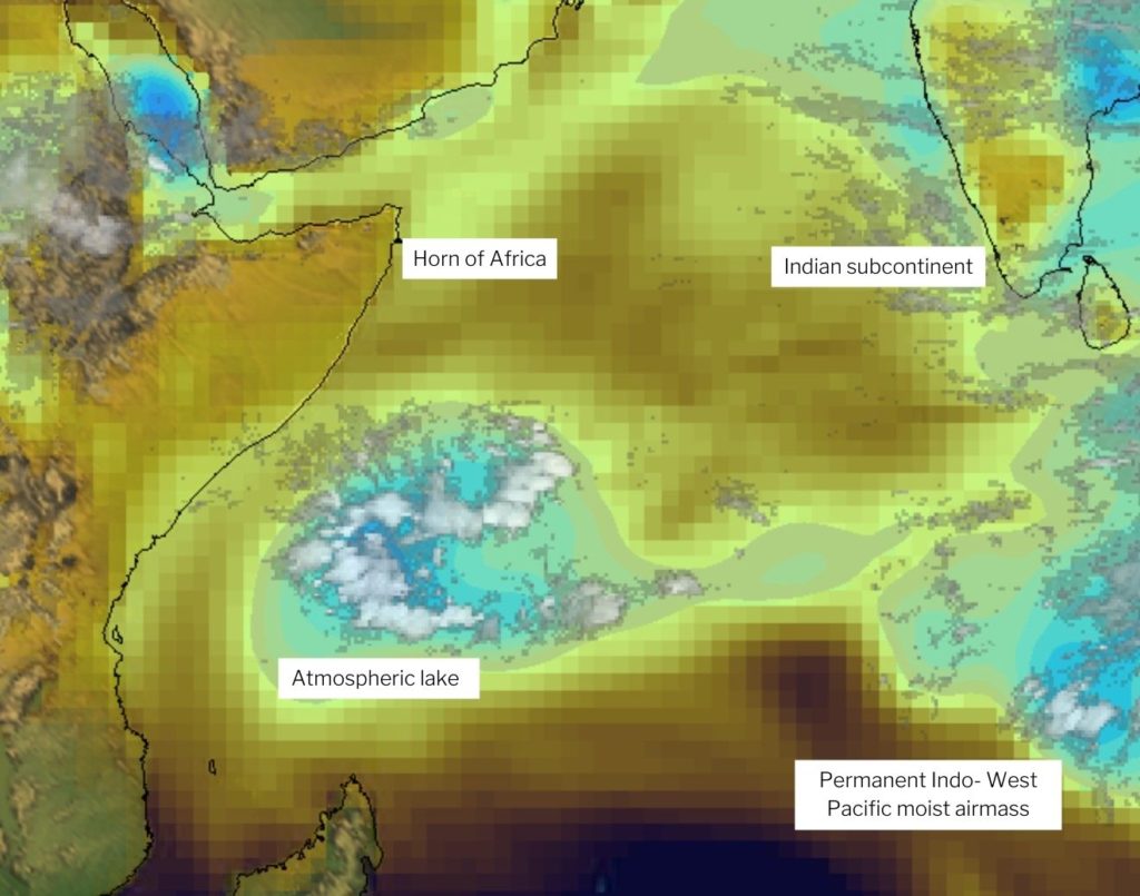
Atmospheric lakes start as filaments of water vapor in the Indo-Pacific that become their own measurable, isolated objects. Credit: Brian Mapes/ NOAA ERA-Interim reanalysis data set.
In an initial survey to catalog such storms, Mapes used five years of satellite data to spot 17 atmospheric lakes lasting longer than six days and within 10 degrees of the equator, in all seasons. Lakes farther off the equator also occur, and sometimes those become tropical cyclones.
The atmospheric lakes last for days at a time and occur several times a year. If all the water vapor from these lakes were liquified, it would form a puddle only a few centimeters (a couple inches) deep and around 1,000 kilometers (about 620 miles) wide. This amount of water can create significant precipitation for the dry lowlands of eastern African countries where millions of people live, according to Mapes.
“It’s a place that’s dry on average, so when these [atmospheric lakes] happen, they’re surely very consequential,” Mapes said. “I look forward to learning more local knowledge about them, in this area with a venerable and fascinating nautical history where observant sailors coined the word monsoon for wind patterns, and surely noticed these occasional rainstorms, too.”
Weather patterns in this region of the world have received little attention from meteorologists, limited mostly to studies of rain and water vapor on a monthly rather than day-to-day scale according to Mapes. He is working to understand why atmospheric lakes pinch off from the river-like pattern from which they form, and how and why they move westward. This might be due to some feature of the larger wind pattern, or perhaps that the atmospheric lakes are self-propelled by winds generated during rain production.
These are questions that would need to be answered before Mapes and other researchers can begin to study how climate change could affect atmospheric lake systems. He plans to study these events more closely using satellite data and will look at into the possibility that these atmospheric lakes occur elsewhere in the world.
“The winds that carry these things to ashore are so tantalizingly, delicately near zero [wind speed], that everything could affect them,” Mapes said. “That’s when you need to know, do they self-propel, or are they driven by some very much larger-scale wind patterns that may change with climate change.”
Video shows man directly hit by thunderbolt
CCTV footage in Jakarta, Indonesia has captured a security guard who luckily survived a direct hit by lightning, according to local media.The 35-year-old, working as a guard for a company dealing with heavy machinery in the north of Jakarta, was on duty when lightning struck him.
In the video, shared by an Indonesian media company and reposted on social media, the man can be seen walking in the rain under an umbrella, with what looks like huge military vehicles parked in the area. Some 15 seconds after he enters the frame, a blast and sparks can be seen in the very place he walked, and the footage then shows him lying on the wet ground. He fails to get up, and people run toward him.
The incident happened earlier this week, local media reported on Sunday, adding that police have confirmed the news.
The man survived, having suffered burns to his hands, according to Detik News. He was initially treated at a hospital, but is now recovering at home. It is believed the guard’s walkie-talkie, which he had in his hands, attracted the lightning discharge.
The odds of being struck by lightning depend on a number of factors, including geographic location. For instance, deaths from such a cause annually reach hundreds in India, while in the US lightning kills an average of 50 people a year. Those who survive, may suffer cardiac arrest, severe burns, and lifelong brain damage. Men are targeted by thunderbolts more often than women, according to the US Centers for Disease Control and Prevention (CDC), which states that around 85% of lightning fatalities are men. Carrying an umbrella is also believed to increase chances of a direct hit, as it makes a possible target higher.
Massive storms and rain in Southwestern France are causing substantial flood:
In Toulouse the Garonne river is overflowing:
In Toulouse the Garonne river is overflowing:
Last edited:
Stormy Winds on the Croatian Coast Tore Down Trees and Electrical Cables
12 January 2022January 12, 2022 - In the past two days, stormy winds on the Croatian coast on Tuesday tore down trees and electrical cables, raised the roofs of houses and overturned vehicles, and some citizens were without electricity for several hours.
HRT News reports that yesterday the County Center 112 Rijeka received several reports of disasters caused by stormy winds in the Primorje-Gorski Kotar County, according to the website of the Directorate of Civil Protection.
In the area of the municipality of Čavle, several telephone poles were broken and a tree fell on the road. In Crikvenica, in King Tomislav Street, the wind blew away part of the tin roof of the family house. A telephone pole in Selce was broken, a tree in the yard of a family house was knocked down in Dramalj, and a truck overturned on a local road in the Kraljevica area. An electric cable fell on the family house in Križišće.
In the area of Rijeka, the tree fell on a personal vehicle in Braće Stipčić Street and in the Orehovica area, and in a warehouse in the port, the wind blew away part of the tin roof. Due to broken poles on the transmission network of Tribalj, Drivenik, and Grižane in Vinodol municipality 1000 users were without electricity from 12:22 pm to 14:26 pm, and in Bribir in Vinodol municipality 200 users from 13:15 pm to 15:14 pm.
In Split-Dalmatia County, the County Center 112 Split received about 20 reports during the day about fallen trees, broken branches, traffic signs, and various objects that fell on the road and obstructed traffic. According to the reports, the competent services were informed. There were no reports of major damage.
In Dubrovnik-Neretva County, the "Dr. Franjo Tuđman" bridge was closed to all traffic due to strong winds from January 10 at 4:50 pm to January 11 at 11:00 am. It was closed again at 3:50 pm, the Civil Protection Directorate reported.
############
Hurricane bora in Croatia destroyed trees, an old house, turns over trucks, and fueles a wildfire near Omis - on the bridge to Krk it hits up to 180 km / h
The bora is still making it difficult to put out the fire near Omis, a truck overturned on the highway during the night, and the driver was killed. In Šibenik felled several trees on cars, and a house in the village of Kričina also collapsed
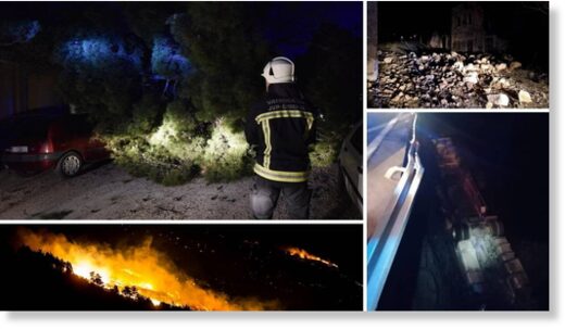
Orkanska bura destroys trees, demolishes a house, overturns a truck and starts a fire near Omis
The strong hurricane began to create numerous problems on Monday, and according to the State Hydrometeorological Institute (DHMZ), it will not subside in the coming days.
Firefighters are still trying to put out the fire that broke out near Lokva Rogoznica near Omis on Monday shortly after 9 p.m.
- The situation on the ground is quite difficult since a strong hurricane wind makes it difficult to put out the fire - said Chief Fire Chief Slavko Tucakovic, adding that there are no endangered facilities.
- The situation at the fire site is the same as last night. We surrounded the fire, but it happened to us that the fire would reactivate after an hour or two. We are fighting, expanding and deploying forces on the ground. Fortunately, we are suppressing it. Last night there was even a fire around the houses, but we put it out. We did the lion's share of the work last night because the hurricane wind made it difficult for us to put it out - said the commander of DVD Omis Viseslav Pesic.
Closed roads
There are many problems in traffic as well. The A1 motorway between the Sveti Rok and Posedarje junctions, the Adriatic highway between Senj and Sveta Marija Magdalena, the state road Maslenica-Zaton Obrovački and the Pag bridge are closed to all vehicles.
- On the Krk Bridge (DC102) traffic is prohibited for I. and II. a group of vehicles in both directions (motorcycles, caravans, caravans with three or more axles, double-decker buses and double-axle buses towing a trailer, passenger cars towing a small single-axle trailer, vans, vans, vans with trailer and trucks with tarpaulins up to 6 tons) due to stormy wind - reports the Croatian Auto Club (HAK).
Wind gusts on the Krk bridge in the early morning hours are close to 180 kilometers per hour , N1 reported .
Truck overturned , driver killed
A truck driver overturned on the highway in a serious accident near Prizna on Monday , and according to JVP Gospić firefighters, the overturning was probably due to a hurricane.
The Lika-Senj Police Department told us that the storm made it difficult for them to investigate the serious accident, and that it would start when the wind calmed down. At the time they received the report of the accident, there was a ban on driving for trucks on that part of the highway.
Another truck driver ignored the bans due to the bora and drove on the highway towards Rijeka in extremely dangerous conditions.
- He had to stop at the Čavle junction towards the Kukuljani settlement in Rijeka because the bora was too strong. It looked horrible, he barely escaped alive - a reader told us.
The house collapsed
due to the bora The old, abandoned house in the village of Kričina near Bribir collapsed last night , and stones and other materials from the house covered the road, so the Bribir-Grižane road was closed to all traffic, Vinodol municipality reported on Tuesday.
Part of the building remained threatened with new collapse, and from Grižan to Bribir it is now possible only through Crikvenica.
Intervention services are on the ground, the Vinodol municipality reported.
Due to the storm in the Kvarner area, branches and trees were felled. Thus, a tree fell on the road in Hreljin, but the locals quickly cut it down and removed it, so there was no long interruption of traffic.
The bora knocked down several trees on cars in Šibenik
In the Šibenik settlement of Šubićevac, a storm bora knocked down several trees on parked cars. Firefighters pulled cars out from under downed trees during the night.
###################
The bora is raging along the coast: gusts of wind carry everything in front of you, look at the dramatic scenes from the Adriatic
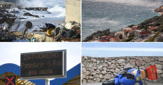
The hurricane bora is raging in Kvarner and Dalmatia, and the blows that the journalists of Slobodna Dalmacija recorded today in the Marina Kaštela in Kaštel Gomilica literally carry everything in front of them.
Numerous olive trees bend literally to the floor, and the sounds of the masts of anchored sailboats create a noise that is extremely unpleasant to the ear.
Sailboats tilt left and right during stronger gusts of the bora, and they also noticed the sailors of Marina Kaštela who used dinghies to tighten the ropes with which boats were tied for safety reasons.
##########
(Translated by Google)
In Norway they had a windy week in parts of the country.
A snowstorm with thunder and lightning created a power outage in Glomsfjord located close to the arctic circle at coordinates:
 66.8166°N 13.9440°E affecting the production of fertilizer. See short clip if it is still up: The storm stopped production for Yara
One section reads when translated:
A snowstorm with thunder and lightning created a power outage in Glomsfjord located close to the arctic circle at coordinates:

One section reads when translated:
There were also cases of rock slides creating a local tsunami. No people were injured, but there were material damages.- There are possibilities for lightning and torrential rain in periods also this weekend, says the meteorologist.
In the last 24 hours, 125 lightning strikes have been registered in Trøndelag and Nordland.
The Norwegian Meteorological Institute had a warning for lightning on Wednesday, Thursday and Friday.
- Is it common for the Meteorological Institute to have a warning of lightning for so many days in a row?
- It is not completely abnormal in the winter. It happens at irregular intervals, says Austerheim.
Danger warning for lightning was introduced last year. Therefore, the meteorologist thinks that we may not be so used to seeing it yet.
Yesterday in Toronto Canada and surrounding areas, there was record snowfall of 30cm + in a single day. Two of the major highways that allows you to get in and out of the city and downtown core were shut down entirely and people were stuck in some places for several hours. The last time there was this much snow was 23 years ago when mayor Mel Lastman called in the army to help clear away the snow. So far today, there are still a lot of obstructions and closures. Two interesting correlations with the snowstorm, 1) yesterday was the first full moon of the year, and 2) the controversial although common sense decision for kids to finally head back to school was supposed to happen yesterday but has now been postponed. But perhaps the most devastating result of the snowstorm was that COVID vaccination clinics were forced to close... 


 www.cp24.com


Toronto, Canada and Global Breaking News – CP24
Most recent News News business news stories and video from CP24
Heavy snowfall blanketed the GTA this morning, shutting down the Don Valley Parkway and the Gardiner Expressway for several hours and stalling hundreds of city buses in the snow.
Environment Canada issued a blizzard warning for the GTA early Monday amid one of the biggest winter storms the region has seen in many years. The national weather agency later downgraded the weather event to a winter storm warning, which eventually was dropped altogether shortly before 6 p.m.
During the peak this morning, about eight to 10 centimetres of snow fell each hour. Wind gusts of up to 60 kilometres an hour are still causing blowing snow across the region.
Snowpocalypse devours the east coast.
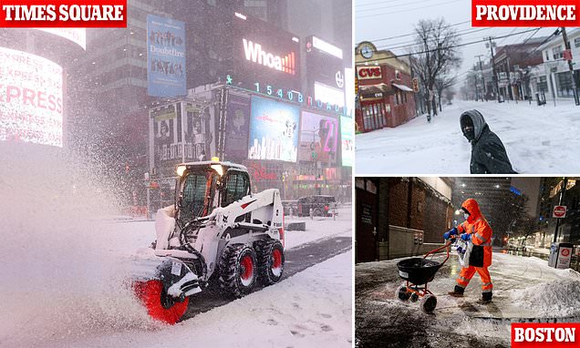
 www.dailymail.co.uk

Snow arrives to NYC as part of potential 'bomb cyclone' on East Coast
While most were hunkered indoors for the heavy snowfall and winds, some were still trying to walk their dogs and do some last minute shopping for supplies before things got really bad.
- Nor'easter slammed into New York City on Friday and Saturday and has blanketed the region with snow
- Up to eight to 12 inches of snow are expected in the area with blizzard warnings in place for 10 million
- More than 3,500 US flights were cancelled on Saturday with more than 1,000 cancellations in NYC area
- National Weather Service reports snowfall of 1 to 2 inches per hours in NYC on Saturday morning
- 'Travel is not recommended,' the service advised. 'If you must travel, use extreme caution'
- Boston could get up to two feet of snow and is bracing for strong gusts and coastal flooding
- In Massachusetts more than 78,000 lost power; Amtrak cancels all train service to Northeast cities
- Freeze alerts in place as far south as Florida, where NWS warned of 'isolated falling iguanas from trees'
Trending content
-
-
Thread 'Coronavirus Pandemic: Apocalypse Now! Or exaggerated scare story?'
- wanderingthomas
Replies: 30K -
-
