Crazy Storm Weather and Lightning - Global

Wyoming

Published on June 8, 2022June 8, 2022-By Jimmy Orr, Cowboy State Daily
Summer weather is back in Wyoming as evidenced by Tuesday’s weather. It was nice and springy in some areas while other parts of experienced a bit more excitement like tornadoes, funnel clouds, and hail.

The National Weather Service of Cheyenne sent out a note on Wednesday morning wondering if anyone had more information about a funnel cloud spotted just east of Lusk.

“Quite the capture!” they wrote of the “brief tornado” which was taken near Duck Creek Ranch just north of Highway 20 at around 2:30pm.

The photo was taken by Garrett Wurdeman and shared with KNEB-TV in Nebraska.

Tornado Chaser Reed Timmer was paying attention to this twister. He had high regard for it.

“Possible TOTY (tornado of the year) east of Lusk, WY yesterday,” Timmer tweeted. “Would have been a solo intercept on Hwy 20 near the historical site. Important to chase the backdoor targets during high plains insanity.”

Timmer did not explain why the tornado could be so highly valued.

The National Weather Service officially declared it a EF 1. That’s the second to the smallest of the “ranked tornadoes.” Still nothing to sneeze at though.

These EF 1s have winds from 86 – 110mph. Some may say that it would be like living in Clark, Wyoming.


tornado-damage-sign-6-8-22-1024x577.jpg


There was some real damage associated with this tornado, however.

Fencing was blown down, roofs were torn off, trees were uprooted,

“The more impressive damage was a barn roof and partial second level were torn off and thrown 50 to 100 yards to the southeast,” the weather service said.


funnel-6-7-22-1024x787.jpg
Photo by Kelle Kristeen Moore


Weather spotter, Kelle Kristeen Moore, produced a photo of another funnel cloud taken the day before 32 miles northeast of Douglas (above).

Not to be outdone, the Thermopolis Independent Record shared a photo of a funnel cloud five miles north of the town taken at 11:30 am on Wednesday (below).


Photo by Lara Love, Thermopolis Record

But the real weather on Wednesday happened east of Wyoming in Sidney, Nebraska. A severe storm dropped more than 10 inches of hail in the community.

According to News Channel Nebraska, the storm lasted four hours and produced ping pong sized hail in numerous towns.


Other Nebraska communities received up to two inches of rain.

In Wyoming, Cowboy State Daily meteorologist Don Day is predicting 90 degree temperatures in the southern and central parts of the state by this weekend and then snow is actually in the forecast.

What Day is calling an “impressive spring storm” will bring wintry-like weather to higher elevations in some parts of the state.

“Spring is still fighting,” Day said. “We are going to do a complete reverse. We have a big summer warmup and then spring comes back and says I’m not done with you yet.”

Somewhat apologetically, Day said he hated to mention the word but snow was a possibility on Monday night and Tuesday in the higher elevations of Wyoming, Utah, and Colorado.

“Nothing like what we had over Memorial Day weekend but a mid-June snowfall in the highest elevations can’t be ruled out,” he said. “This front is really impressive.”


Lyon Fr.
The Rhône was affected by major storms yesterday, which caused flooding and power cuts in some municipalities


Texas

1654757302932.png

#Orkan with gusts of around 162km/h near the city #Miyako ( #Japan ) in the evening! Upcoming #storm for 06/12/2022 - 12:00 UTC with #gusts 162km/h expected near #Miyako (model #ICON #DWD , #Extremwetter ).

1654758609606.png
 
Came across this picture of huge hailstones (13cm) that fell from the sky in Beatrice, Nebraska! The storm hit the area yesterday. Can't seem to post the FB link here, but here it is.

Found some footage here:


Local news report:

Severe weather hits Gage County​

Severe weather struck Gage County Saturday afternoon, leaving significant damage behind.

The National Weather Service urged residents in Gage County and elsewhere in Southeast Nebraska to take cover shortly after 5 p.m. as threats of a tornado, hail and heavy rain entered the area late Saturday afternoon.

At 5:25 p.m., law enforcement confirmed a tornado was located near Wymore — 12 miles southeast of Beatrice — moving southeast at 20 mph.

The weather service issued a tornado warning for northwestern Gage County, including Beatrice, and parts of Lancaster, Saline and Jefferson counties.

A separate tornado warning in Gage County included Wymore, Blue Springs and Barneston, the weather service said on Twitter.
Softball-sized hail caused widespread damage through Beatrice, damaging vehicles, breaking windshields and causing extensive damage to a number of homes.

The storm moved quickly, causing those in attendance at the Big Blue Water Park in Beatrice to seek shelter inside the building and many cars traveling along Highway 77 throughout Beatrice to pull off the road and seek shelter from the hail.

Storm damage left parts of Wymore, Beatrice, Diller and other communities without electricity for varying amounts of time. Around 7:30 p.m. power was restored to most of Beatrice.

By 9 p.m. Norris Public Power had restored service to Diller. A transmission line feeding substations in Southern Gage County was damaged but expected to be operational around the same time, thereby restoring power to parts of southern Gage County.
Residents in Wymore, where the storm damage was extensive, were expected to wait longer for electricity. Around 9 p.m. the City of Wymore Facebook page posted that "due to extensive damage and downed lines, we are having to call out of town storm crews to help get us back up and running."

The post said power outages were expected to last until Sunday or possibly longer as crews worked on restoring power lines and cleaning storm debris.

The weather service also warned of severe thunderstorms in the Omaha metro area, north of Omaha in Washington County and west of the city near Gretna. A funnel cloud was reported 3 miles southwest of Papillion at 6 p.m. and winds gusted up to 61 mph.

A tornado watch remains in effect for Southeast Nebraska, until 10 p.m. Saturday, the Lancaster County Emergency Management Agency said.

"Any storms that develop will likely turn severe very quickly," the agency said on Twitter. "Make sure you have a plan in place when severe weather strikes."

Source
 
This Sunday there was a strong hailstorm in Mexico City, which covered large areas of the capital in white, although it also caused various damages.

Civil Protection of Mexico City reported that due to the accumulation of hail,
collapsed a ceiling of approximately 35 meters by 20 meters, of a self-service store.
Despite the severity of the incident, no injuries were reported.

In the same way, floods are registered in the mayor's offices of the west and center of the city

 
Possible rare ball lightning, UK,
I saw a ball of lightning, nearly 30 years ago, up close.

I had driven 6 hours, to visit an old school friend, just pulled up in front of her house, when a ball of lightning came whizzing through the sky, and hit a transformer, on a pole, just across the street, in my line of vision. The explosion was terrifying!


1655639603852.png

It's like the whole country has become electrified.

Risk forecasts #meteo by the municipality by the AROME model for Sunday #orages on the north and west. #canicule further east.

https://twitter.com/meteophile/status/1538445459013918722

Possible rare ball lightning, UK, or a UFO (!)
I wonder if the 4Dsts time travelers can use these electrical storms as portals, as well as energy collectors.

Feb. Brisbane, Queensland Australia
Aug 23, 2017
 
Nice storm actually south BE, quite violent, many thunders + an intense shower of hailstones, small ones but i had the bad idea to put my hand outside and when i received one on my finger are rapidly removed it 😅
Wonder if i already saw that during my life in June, hailstones ! I can't help to think that this can clearly damage young plants, i wonder if this will have impacts at this level.
 
1655800360481.png
1655800463950.png

June Snow Trifecta For Tahoe - Record Snow Australia - Record Greenland Ice Gain - Jupiter Impact
Premiered 11 hours ago Oppenheimer Ranch Project


🧐🤔😬
New #orages with intense rain, #grêle and gusts of wind are feared this Tuesday at the end of the afternoon and evening, in particular on an axis going from Midi-Pyrénées to Bourgogne-Franche-Comté . (via @wxcharts )
 
Looks like hail is the marker of the season around the world.... :-(

Also happened in Germany:

Tweet says:
A #supercell caused very large #hail grains in the canton of #Bern in the late afternoon. More strong #thunderstorms are on the way.


(machine translation)

After record heat: severe storm causes some total damage​

Thursday, 06/23/2022 - 09:46

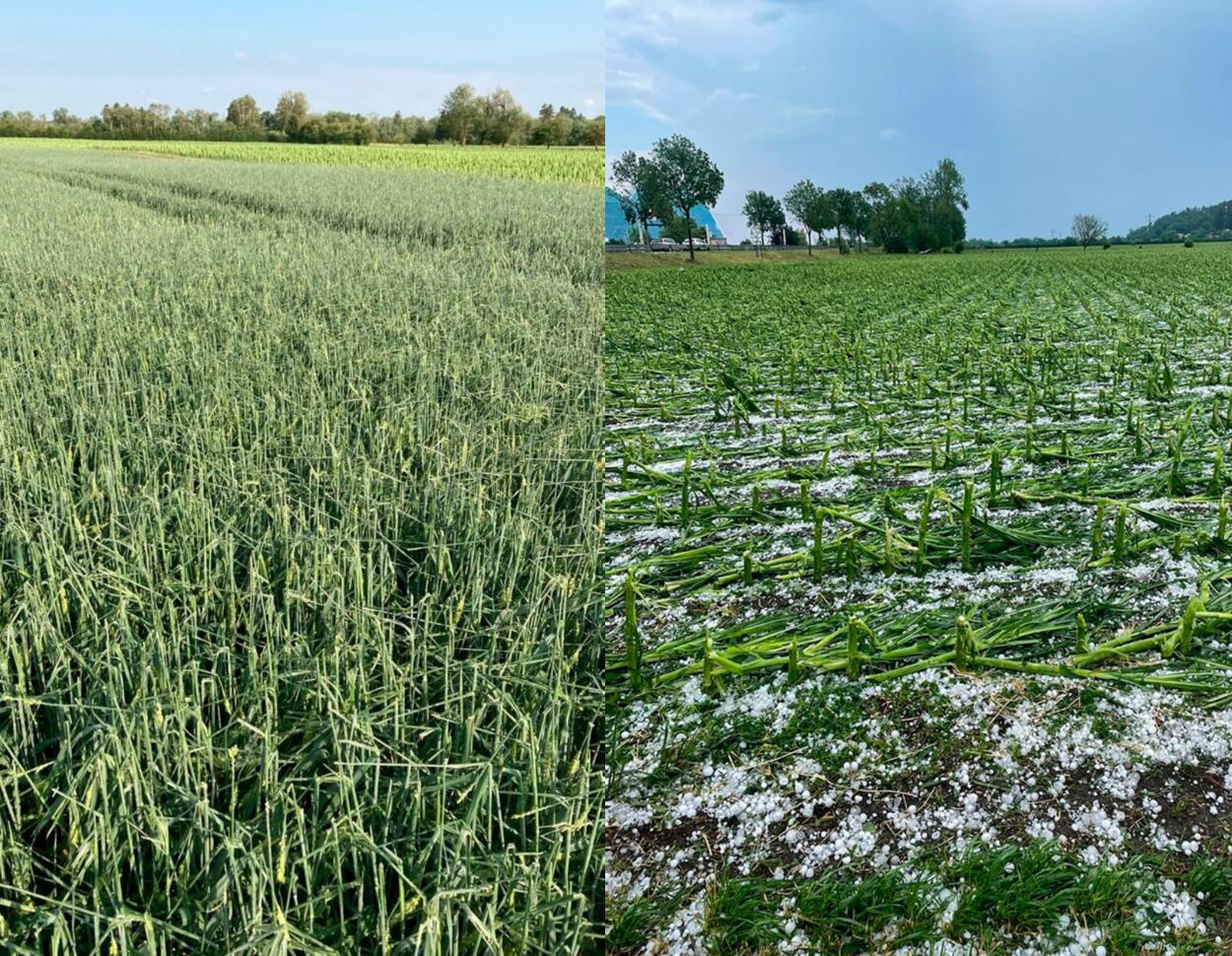
Damaged grain and maize areas in Bavaria after a storm

© Vereinigte Hagel The severe storm caused massive damage to the fields in southern Germany at the beginning of the week. Corn, cereals and beets were affected.

After the record heat, a severe storm swept over Germany at the beginning of the week. In Bavaria alone, 20,000 hectares were damaged, some of them severely.
As the United Hagelversicherung reports, storms in recent days have caused massive damage to agricultural land in Germany.
At the press conference at the DLG field days last week, there was still talk of a rather moderate claims experience - but this has now suddenly changed. The south in particular is severely affected.

Storm depression: Total losses in corn, grain and beets​

Damage to beets and hops in Bavaria after a storm
© Vereinigte Hagel Some of the storms in Bavaria caused total damage to beets and hops.

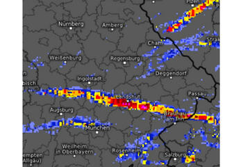
The record heat from Hoch Efim on Saturday and Sunday with almost 40 degrees Celsius was followed by storm "Ophelia". In addition to the cooling, it unfortunately also brought storms, heavy rain and, above all, hail, according to the insurance company. The low crossed all of Germany and caused serious damage, especially in the southern half. On a 300 km long strip from Günzburg to Bad Füssing, it led to total losses in maize , grain and beets.
But the Hallertau was once again affected, especially in the communities of Au in der Hallertau and Wolnzach, reports the United Hagel.
There was also isolated damage in the Rhineland, Thuringia and Saxony.

At least 20,000 hectares in Bavaria were damaged by the storm​

The storm zone moves over Bavaria
© United Hagel The storm swept across Bavaria in a strip about 300 km long.

From Bavaria alone, the insurance company has so far received reports from more than 20,000 hectares of damaged area, including several hundred hectares of hop plantations. According to the United Hagel, one is currently assuming a damaged insurance sum of 50 million euros.

However, the extent of the damage actually is in the end will now be shown by the assessments that have already started. It is said that the Bavarian experts would have to regulate 6,000 individual fields in the coming days. They would be supported by colleagues from other federal states so that everything could be carried out quickly.


Here is also one extensive report about hail storms in France:
 

Trending content

Back
Top Bottom