"Hail in Châteauroux this Sunday. The powerful #supercell having hit #Châteauroux ( Indre ) this Sunday evening did enormous damage with large hailstones damaging many vehicles, roofs, garden furniture. Photos: C. Grodet, M. Turpin and J. Beucher."
You are using an out of date browser. It may not display this or other websites correctly.
You should upgrade or use an alternative browser.
You should upgrade or use an alternative browser.
Crazy Storm Weather and Lightning - Global
- Thread starter mabar
- Start date
There was a strong and powerful front (from the south) that blew through here with wind speeds that seemed like 50km an hour. Thankfully it ended quickly while moving north of this location.The powerful #supercell
I swear that the home crystals have continued to be advantageous to this area with protection.
TYVM!
Nearly 36,000 lightning discharges since the start of the deterioration at the end of the day yesterday Sunday. We can distinguish the imprint of the supercells, of which the most massive born in #DeuxSèvres which persisted until #Bourgogne . #orages
#Orages accompanied by #grêlons sometimes very impressive last night on the center-west.
"A user, who wishes to remain anonymous, told me that the roof was pierced by hailstones of 9-10 cm (4 inches) on average (12 cm at the peak - 5 inches) in Poitiers and Chauvigny in France. Incredible."
"The end of the heat period is painful. Hailstones exceeding the size of a petanque ball fell in Deux-Sevres. Feedback on crops and agricultural buildings? Photo: ML Kriss Gémeaux in Fontenay-Rohan-Rohan"
"We can clearly see on the sat image this very virulent supercell storm which passed near Niort and which is moving towards Poitiers. We can clearly see the signature of a summit penetrating the tropopause. Sign of the most violent storms."
Last edited:
Hi @Laurentien2, I was thinking about you as the storm was whipping through here in Ottawa last night. I was hoping you didn't get hit too hard in the hills.
I think we were lucky, I just checked how Maat was doing in Val-David and they are still without electricity. No damage at her house and they have a generator so they can still keep the refrigerator cold and use the BBQ to prepare meals. There was twister reported all around, the damage on the electrical grid is major, it may take up to a week and more to repair. My wife just called an employee who live in Mt-Tremblant in the old village and hundreds of trees are down, road close, power line laying on the ground and a house was flatten by 3 trees that felt on it. I went in the forest for a short walk with my dog and everywhere up-rooted tree are seen. Yesterday was the crazy run for the population to buy petrol, there was line of vehicle were garage were open and policeman had to be present to control the unprepared population. I have reserve of petrol for a couple of weeks for running my generator to keep my freezers cold, that give us time to transform the meat we have. I have close to a 100 masson jars ready just in case. Yes that storm will hopefully make people realise how quickly our life can be turned upside down and unprepared they are. Just imagine this happening in winter and most houses without a proper alternative and efficient heating system.
unkl brws
The Living Force
The Paroisse Saint-Hugues in Sarsfield was significantly damaged by the storm.
The death toll from the storm is now at nine people.


 www.ctvnews.ca
The death toll from the storm is now at nine people.

Death toll from Saturday's storm hits 10 across Ontario and Quebec
As the death toll related to the powerful storm that swept Ontario and Quebec on Saturday reached 10 on Monday, some of the hardest-hit communities were still working to take stock of the damage.
Just insane and extreme weather patterns! Hail and lighting rains king in the north and central positions of the country.
Storm tonight in Châteauroux...
[Timelapse] Very active cell (sustained electrical activity and intense rain) which made the Cholet (49) / Le Mans (72) axis. Shooting from the Antoigné wind farm (49) @KeraunosObs @Estofex @meteociel @lachainemeteo @MeteoPDLL
Ocean air pushes warm air out. This Tuesday, it will be cooler than normal over 3/4 of France, a first since the beginning of April! http://meteo-express.com/previsions
Germany
Line-1
In addition to #Hagel brought the #Gewitterzellen partly also intense #Regen . Within 30 minutes, for example, around 30 mm of precipitation fell in #Luzern . ^ng/buc
Line-2
Here is the impressive #SRFMeteoVideo from #Luzern by A. Münchow. ^ng Sarina Nezhadian)
Large A fierce hailstorm fell on Varaždin, Croatia, the ice was the size of a walnut, the streets were flooded
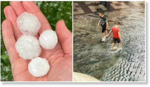
The region was flooded by fierce hail, sometimes the size of an average walnut .
It rained hail for at least 10, and maybe 20 minutes. Havy damage on agricultural and small family farms.
More videos on link above.
****
At the same time, in Sisak, Croatia, a heavy storm hit with a hail and a tornado!!!
More videos and pictures on link above.
****
Here is article in english that pretty much coveres all above:
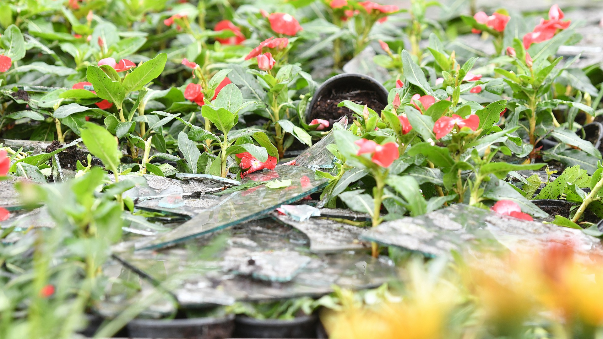

Severe storms cause massive damage in northern Croatia
Along with millions of Kuna in damages to crops and companies, citizens from the eastern part of Varaždin County also saw the homes and cars destroyed by the hail storm that showered the region with walnut-sized balls of ice.
glashrvatske.hrt.hr
Severe storms cause massive damage in northern Croatia
Along with millions of Kuna in damages to crops and companies, citizens from the eastern part of Varaždin County also saw the homes and cars destroyed by the hail storm that showered the region with walnut-sized balls of ice.
Northern Croatia was hit by a severe storm on Wednesday night, with hail destroying almost half of Croatia's total flower production. Family homes saw massive damage to roof-tops as the hail smashed through roof tiles, while cars were left with broken windshields and pock marks the size of golf balls. The hardest hit area was the eastern part of Varaždin County. Varaždin County Prefect Anđelko Stričak and Agriculture Minister Marija Vučković visited the area today.
"When you see all of these greenhouses, it's lucky that no one was in them when the storm hit, because had there been, today we'd be talking about how many people were injured and possibly even killed," Stričak said.
For her part the Agriculture Minister promised that government would help those affected by the storm: "We have a large measure for the reconstruction of this kind of production potential, and we will help people. We need to openly communicate the specifics of the challenge we all face, which is to enable them to resume work in a very short period of time, given the specifics of this kind of production."
Hail also ravaged the municipality of Hum na Sutli in Krapina-Zagorje County, damaging roofs, solar panels, crops and cars. The municipality has called for the County Prefect to declare a state of natural disaster. Municipal head Mario Antonić: "It all happened within a minute or two, it battered dozens of cars, destroyed numerous roofs, solar panels, the cars parks of the big companies here - such as OMCO and Vetropak, crops and fruit orchards have been destroyed. Simply put, this is a catastrophe."
A storm hit the Sisak area last night. The settlements of Greda, Sela and Odra Sisačka suffered the most, where hail caused damage to houses and farm buildings, and strong winds uprooted several trees. Miroslav Golub from the Sisak Fire Department: "48 firefighter and eleven trucks were dispatched to more than 30 locations. Within ten minutes of the tornado they were helping their fellow citizens remove debris and covering damaged houses and buildings with tarps."
Source: HRT
Another storm in north and east Croatia:

 www.total-croatia-news.com
May 28, 2022 - Last night, a major storm in northern Croatia affected the areas of Varaždin, Čakovec, and Koprivnica, tearing down trees, public lighting, and flooding streets. The inhabitants of Varaždin, informed in advance, parked their cars in underground garages.
…In Koprivnica, 16 liters of rain per square meter fell, and in some villages, such as Torčec, even more.
***
More videos here; I’m sorry I cannot add them here


Storm in Northern Croatia: Varaždin, Čakovec and Koprivnica Damaged
Last night, a major storm in northern Croatia affected the areas of Varaždin, Čakovec, and Koprivnica, tearing down trees, public lighting, and flooding streets. The inhabitants of Varaždin, informed in advance, parked their cars in underground garages.
May 28, 2022 - Last night, a major storm in northern Croatia affected the areas of Varaždin, Čakovec, and Koprivnica, tearing down trees, public lighting, and flooding streets. The inhabitants of Varaždin, informed in advance, parked their cars in underground garages.
…In Koprivnica, 16 liters of rain per square meter fell, and in some villages, such as Torčec, even more.
***
More videos here; I’m sorry I cannot add them here

Veliko nevrijeme na sjeveru Hrvatske: Vjetar rušio rasvjetu, bilo je i tuče
NEVRIJEME je noćas pogodilo sjever zemlje - varaždinsko, čakovečko i koprivničko područje
www.index.hr
Attached is a time lapse of the well-condensed funnel cloud this afternoon in the district of Fürstenfeldbruck. The funnel cloud was visible for more than five minutes and was almost stationary during this time
Wind shear can be a storm's best friend or worst enemy
By Jessica Storm, AccuWeather Meteorologist & Jesse Ferrell, AccuWeather meteorologistSnip:
It's a term frequently mentioned by meteorologists, but the phenomenon can have radically different effects depending on the type of storm it influences.
One of the staple terms meteorologists mention frequently when discussing the possibility for tropical development is wind shear. But what is wind shear? And what does it have to do with tropical cyclones and other weather patterns?
Simply put, wind shear is the change in direction and speed of winds throughout the various levels of the atmosphere.
Understanding how wind shear influences weather patterns is somewhat complex as there are multiple types of wind shear and because it can be a factor over the ocean as well as overland.
Wind shear in tropical storms
When issuing forecasts for the tropical Atlantic, forecasters typically examine vertical wind shear, which is the change in winds at increasing heights in the atmosphere. Generally, strong vertical wind shear is bad news for tropical storms and hurricanes.
"Vertical wind shear is the most influential factor as far as tropical cyclones are concerned," AccuWeather Senior Meteorologist Alex Sosnowski said.

Tropical systems and hurricanes grow by becoming vertically stacked. "It can be helpful to visualize a stack of pancakes," AccuWeather Meteorologist Alex DaSilva explained. When winds vary in speed and direction at the bottom of the atmosphere compared to higher levels of the atmosphere, the top of a tropical system can be pushed and tilted away from its base, causing it to become lopsided. If a mature hurricane is in place, it may weaken but will not necessarily dissipate.
Last edited:
syldan
Dagobah Resident
In Sainte Adèle, Québec: We were hit by a Tornado on Saturday Mai 21st, we only got electricity back yesterday. Land lines are still down. I was siting outside in a gazebo waiting for the rain to slow down, and if I had not run for the house the exact moment that I did - through sheets of rain - I would not be here to tell you about it. My housemate was in the patio door and he saw me running towards him as trees literally came straight for me one after another. I lunged out of the gazebo when I saw the other gazebo at the back of the yard fly straight up in the air, that is the signal that saved my life. 2 big pine trees fell on the table in front of me and directly on the chair where I was sitting, and as I passed the greehouse a tree fell on that too!. My housemate was in shock for 2 days, when I reached the patio door there was 4 huge trees on the ground behind me. The fact that I should be dead, and that I was miraculously saved by a hair's breath makes me think that there must have been some sort of timeline branching. There are more than 20 big trees either uprooted of broken in half on the property. Luckily nobody in our area was hurt but we read that there were deaths in Ontario from same storm, houses collapsed in Québec area, etc.
Here are pictures after we did a lot of cleaning and sawing, had the wind been 15 degrees different the 4 trees would have crashed into the living room of the house, fortunately only the garage, the shed and our big tree house were hit: (funny thing is that I was never scared whereas my roomy and our lady friend were in shock?) They described it as if it were out of a Tom Cruise movie, surreal. The white stuff is a greenhouse and it's black shelving topled over, and the 2 big pine on the ground behind it is the gazebo where I was sitting complety flatened.
![20220521_170542[1].jpg 20220521_170542[1].jpg](https://cassiopaea.org/forum/attachments/20220521_170542-1-jpg.59103/)
![20220528_123441[1].jpg 20220528_123441[1].jpg](https://cassiopaea.org/forum/attachments/20220528_123441-1-jpg.59100/)
![20220529_073527[1].jpg 20220529_073527[1].jpg](https://cassiopaea.org/forum/attachments/20220529_073527-1-jpg.59101/)
![20220528_123256_HDR[1].jpg 20220528_123256_HDR[1].jpg](https://cassiopaea.org/forum/attachments/20220528_123256_hdr-1-jpg.59102/)
Here are pictures after we did a lot of cleaning and sawing, had the wind been 15 degrees different the 4 trees would have crashed into the living room of the house, fortunately only the garage, the shed and our big tree house were hit: (funny thing is that I was never scared whereas my roomy and our lady friend were in shock?) They described it as if it were out of a Tom Cruise movie, surreal. The white stuff is a greenhouse and it's black shelving topled over, and the 2 big pine on the ground behind it is the gazebo where I was sitting complety flatened.
Last edited:
syldan
Dagobah Resident
I forgot to mention, we bought 2 generators and both were broken in the box. One from Amazon (Hyundai) ran 4 hours, the other (King Canada) not a single minute. I will take them apart now that we have power back. After we get the trees out of the roofs in the back, that is. I was thinking of how bad a situation for an older person or couple, to spend nearly a grand, and to come home without being able to get the thing to work. Lucky for us that I know a little bit about this stuff. We got stiffed!  but I still have my legs, arms, and head screwed on! When talking with the Hydro-Qc lads who came in big numbers, they related that this is the new normal for stuff made in China to come pre-proken, maybe they don't like us? Wink-wink! I wonder why that would be. The Hyuindai came with a hole drilled in the gas tank, seriously, I had to patch it with epoxy. (Deliberate? It sure seemed like it. These are assembled by robots so if one is badly assembled, then an entire series would ensue, unless someone notices the mistake before shipping. I've gone off Amazone since last summer, half the stuff we bought was crap!
 but I still have my legs, arms, and head screwed on! When talking with the Hydro-Qc lads who came in big numbers, they related that this is the new normal for stuff made in China to come pre-proken, maybe they don't like us? Wink-wink! I wonder why that would be. The Hyuindai came with a hole drilled in the gas tank, seriously, I had to patch it with epoxy. (Deliberate? It sure seemed like it. These are assembled by robots so if one is badly assembled, then an entire series would ensue, unless someone notices the mistake before shipping. I've gone off Amazone since last summer, half the stuff we bought was crap!
Last edited:
Gonzo
The Living Force
Just east of there, my friend has property we visit regularly. A couple of decades ago, he planted hundreds of black walnut trees in the hopes of harvesting them in the future and selling the valuable wood. He thinks he lost half of them, and the canopies and many of the survivors we damaged. Probably still safer than digital currencies though.The Paroisse Saint-Hugues in Sarsfield was significantly damaged by the storm.
The death toll from the storm is now at nine people.
View attachment 58880

Death toll from Saturday's storm hits 10 across Ontario and Quebec
As the death toll related to the powerful storm that swept Ontario and Quebec on Saturday reached 10 on Monday, some of the hardest-hit communities were still working to take stock of the damage.www.ctvnews.ca
Gonzo
The Living Force
Glad you have electricity now. Hopefully you will continue to keep them all on with the chainsawing!...
We got stiffed!but I still have my legs, arms, and head screwed on!
...
I'm going to hazard a guess that firewood might be a little less expensive next year.
unkl brws
The Living Force
It's been about a week and a half since this storm and there are STILL people without power in the city of Ottawa!Glad you have electricity now. Hopefully you will continue to keep them all on with the chainsawing!
I'm going to hazard a guess that firewood might be a little less expensive next year.
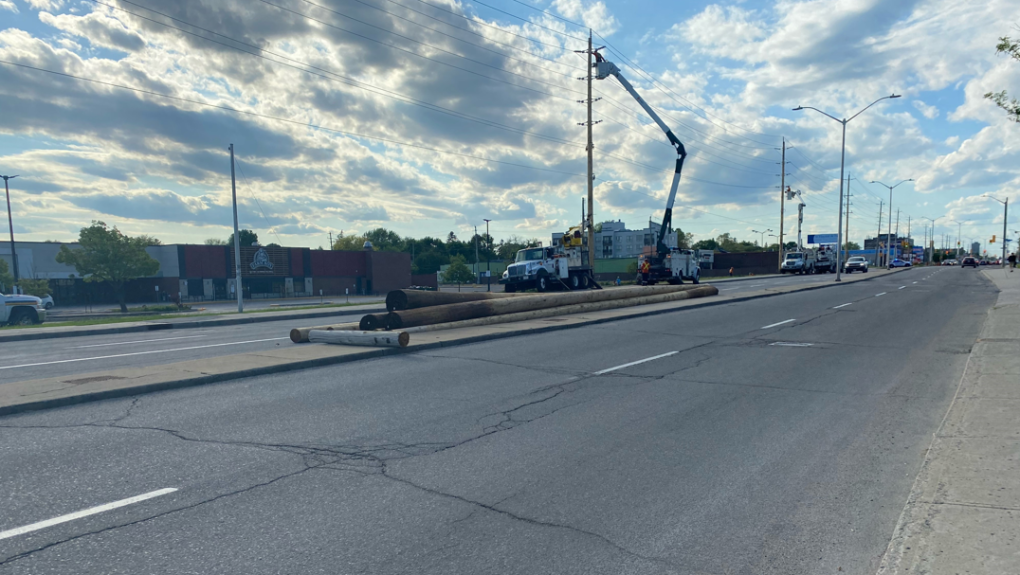
Hydro Ottawa offering clearer picture of restoration for remaining customers
Hydro Ottawa has restored its online power outage map to provide a clearer picture to the remaining customers waiting for their power to be restored this week.
Apparently, Canada can expect more weather like this as the summer rolls on.

Hot summer temperatures, big storms to sweep much of Canada, Weather Network predicts
Seasonal or higher than normal temperatures across much of the country will offer Canadians a chance to enjoy the summer, but predictions from a prominent national forecaster warn the humidity could welcome a rather stormy few months.
Trending content
-
-
Thread 'Coronavirus Pandemic: Apocalypse Now! Or exaggerated scare story?'
- wanderingthomas
Replies: 30K -
-
