The meteorological satellite "Himawari-8" successfully captured atmospheric gravity waves! https://iflscience.com/space/check-out-these-orbital-animations-of-gravity-waves-over-australia/ The meteorological satellite "Himawari-8" succeeded in photographing the atmospheric gravity wave that was generated and disappeared and spread to a wide area. Atmospheric gravity waves are one of the major waves in the atmosphere that have buoyancy in the atmosphere as a restoring force.
You are using an out of date browser. It may not display this or other websites correctly.
You should upgrade or use an alternative browser.
You should upgrade or use an alternative browser.
Crazy Storm Weather and Lightning - Global
- Thread starter mabar
- Start date
Chad
The Living Force
The 2nd medicane (hurricane like storm in the Mediterranean sea) in 2 weeks has continued to develop since predictions by severe-weather.eu a few days ago that one was building. The last one made its way to Egypt and was predicted to dump a load of rain over there (and i think it did).
It really does seem as though both in the Atlantic and the Med that there's just one storm after another at the moment.
Below are some details pulled from their site and a tweet showing the latest satellite imagery.
It really does seem as though both in the Atlantic and the Med that there's just one storm after another at the moment.
Below are some details pulled from their site and a tweet showing the latest satellite imagery.
Increasing potential for the development of two warm-core systems (medicane) in the Mediterranean early next week
By Marko Korosec | Mesoscale Discussion | 08 November 2019
The progressive pattern across Europe will also bring a deep trough towards the SSW Europe early next week, with a deep long-wave trough pushing a deep core into the SW Mediterranean. Some models are hinting a development of a deep cyclone with the potential of the warm-core system in the western Mediterranean on Monday and then another even stronger warm-core cyclone over the Tyrrhenian sea on Tuesday. Let us take a look over some details on the models.
The pattern over the weekend into early next week supports a long-wave trough digging far south into SW Europe and into the Mediterranean. Based on the latest runs today, Friday, Nov 8th, the trough will likely transform into a large upper low with a deepening core on early Monday. Additionally, this will result in a rather rapidly deepening surface cyclone.

请稍候…
www.severe-weather.eu
/QUOTE]
Hurricane Dorian, the aftermath recovery, and other anomalies.
Hurricane Dorian Was Worthy of a Category 6 Rating ...
October 3, 2019 Snip:
Category 5 Atlantic hurricanes are rare. Only 7% of the 243 hurricanes observed since accurate satellite measurements began in 1983 have reached that catastrophic intensity. And it is truly exceptional to see a category 5 hurricane as strong as Hurricane Dorian, which powered ashore on Great Abaco Island in The Bahamas on September 1, 2019, with sustained winds of 185 mph and gusts up to 220 mph. Winds of this strength would make Dorian worthy of a category 6 rating, if it existed. (For those of you unfamiliar with me, know that there is already a Category 6—it’s the name of a blog I co-author with Bob Henson over at Weather Underground, specializing in daily updates of global tropical cyclone activity).
The Saffir-Simpson Hurricane Wind Scale, which is used to rank hurricane winds on a scale of one to five, stops at category 5: sustained 1-minute average wind speeds of at least 157 mph (70 m/s). If we were to add a category 6 to the scale, we must consider that the scale is not quite linear. Winds for a category 2 hurricane span a range of just 15 mph, for example, but winds for a category 4 storm span a range of 27 mph. Regardless of this non-linearity, a one-category increase in intensity on the scale results in approximately four times more wind damage, according to the National Hurricane Center.
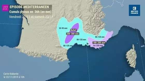
Storms: 11 departments of the South-East alert, a missing person in the Var https://sudouest.fr/2019/11/23/int
Hail and tornadoes
Friday night, Météo France was between 40 and 90 mm on the Cevennes, between 30 and 70 mm on the Var and the Alpes-Maritimes. Météo France forecasts that the intensities of the precipitation will strengthen in the night and Saturday morning with a stormy aspect more and more present. "Values of 30 to 40 mm in one hour will be possible between the morning and the beginning of Saturday afternoon near the Var and Alpes-Maritimes".
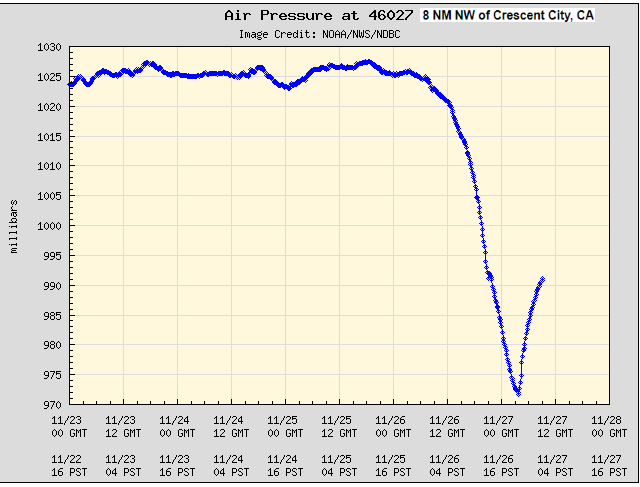
Winter storm, (‘Bomb Cyclone'), will move fast, and hard on the west coast of the United States.
Also the continued slower moving cold blast for Europe.
And, Subtropical Storm Sebastien on the move.
Also the continued slower moving cold blast for Europe.
And, Subtropical Storm Sebastien on the move.

A Puzzling Collapse of Earth's Cooling Upper Atmosphere
NASA-funded researchers are monitoring a big event in our planet's atmosphere. High above Earth's surface where the atmosphere meets space, a rarefied layer of gas called "the thermosphere" recently collapsed and now is rebounding again. "This is...
 www.sott.net
Bomb Cyclone Slams US with Tropical Snow & Sudden Stratospheric Event Begins (916)
7:18 PM · Nov 30, 2019·David DuByne 08:59
Yozilla
The Living Force
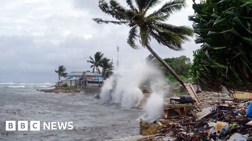
Freak waves flood Marshall Islands homes
MAJURO – More than 200 people have been forced to flee their homes after they were inundated by freak waves in the Marshall Islands’ capital, Majuro.
Swells averaging 5 meters (16 feet) washed rocks and debris onto roads, temporarily cutting access to the international airport at the peak of the flooding on Wednesday.
Freak waves flood Marshall Islands homes | The Japan Times
This is, of course, being spun as evidence of "man made global warming"
Climate change: COP25 island nation in 'fight to death'
The president of the Marshall Islands tells a summit that rising tides threaten its existence.
 www.bbc.com
angelburst29
The Living Force
12-23-2019 - In the past two weeks in Northeastern Pennsylvania, we have only experienced a dusting of snow, here and there but the temperature fluctuations have cause icy conditions. I would rather deal with snow, then ice. Last Winter started out the same way, then in February and March, we got hammered with snow storms and minus 0*F. The top of the snow had a glassy appearance with an inch or more of ice.
In the news, a neighboring State - Virginia got a double dose of icy conditions and thick fog.
Dozens injured as over 60 cars left mangled in pileup on I-64 in Virginia (Video - Photo)
https://www.accuweather.com/en/weat...35-vehicle-pileup-on-i-64-amid-ice-fog/649777
Amid foggy and icy conditions on Sunday morning, a devastating pileup involving over 60 vehicles in Virginia left dozens of people injured.
The accident occurred on Interstate 64 near Norfolk just before 8 a.m., local time, when patchy fog and black ice were reportedly in the Queens Creek Overpass area. Virginia State Police confirmed 51 people were taken to regional hospitals, including 11 people who sustained serious injuries.
According to the police, 69 total vehicles were involved in the wreckage. Photos depicted firefighters and other emergency personnel standing on the hoods of mangled vehicles looking for people to rescue. Initial reports on Twitter stated that injuries ranged from minor to life-threatening, but the 5 p.m. update from the state police confirmed that no fatalities or life-threatening injuries were reported.
"My thoughts are with all involved in the multi-vehicle accident near Williamsburg this morning," Virginia Gov. Ralph Northam tweeted on Sunday. "Grateful for the emergency crews, first responders, hospital staff, @VSPPIO, and @VaDOT personnel who are working around the clock to keep people safe this holiday season."
Bray Hollowell, a survivor of the pileup, told WTVR.com that the accidents were an "apocalyptic moment." When the weather turned quickly, the foggy conditions dashed any hopes of visibility.
“It really just got really foggy really quick,” he said. “I just was driving on the bridge and then out of nowhere I see and accident and I just brake. And I couldn't really do much to avoid, I just ran into people.” Holloway said he considers himself lucky and fortunate to walk away uninjured.
In the immediate aftermath of the accidents, the Virginia Department of Transportation closed both the westbound lanes, where the accidents had occurred, and the eastbound lanes, due to the rubber necking of cars driving by. At 3:35 p.m., local time, the department announced on Twitter that both eastbound and westbound lanes were reopened.
"In situations such as this, the road may appear wet, rather than icy, hence the term black ice," AccuWeather Senior Meteorologist Alex Sosnowski said.
According to Sosnowski, temperatures ranged from the upper 20s to the lower 30s in southeastern Virginia before and shortly after daybreak with areas of fog.
"The sudden low visibility in parts of the region created a dangerous visibility situation on top of the black ice condition," Sosnowski said.
"This just demonstrates that even during a mild and storm-free weather pattern, that a few fog patches this time of the year can be dangerous with freezing temperatures," Sosnowski said.
angelburst29
The Living Force
Christmas turned to chaos for many holiday observers in the central Philippines as a typhoon with strong winds and heavy rains destroyed homes, cut off power and stranded travelers, disaster officials said on Wednesday.
Philippine typhoon Phanfone ruins Christmas for travelers, evacuees

Typhoon Phanfone ruins Christmas for thousands of Filipinos
Typhoon Phanfone ruins Christmas for thousands of Filipinos
Officials on Christmas Eve said residents should evacuate coastal areas.
#UrsulaPH (#Phanfone) has been upgraded to TYPHOON strength. An eye is appearing right in the satellite image as it approaches Central Philippines.
Very dangerous situation since tomorrow is Christmas Day.
Stay safe! pic.twitter.com/WFhBOwYLpt
— Tropics Weather (@TropicsWeather) December 24, 2019

Though much weaker, Phanfone was tracking a similar path as Super Typhoon Haiyan, the country's deadliest cyclone on record which left more than 7,300 people dead or missing in 2013 Image Credit: Courtesy of Joint Typhoon Warning Center
Philippine typhoon Phanfone ruins Christmas for travelers, evacuees
Typhoon Phanfone ruins Christmas for thousands of Filipinos
Typhoon Phanfone ruins Christmas for thousands of Filipinos
Officials on Christmas Eve said residents should evacuate coastal areas.
#UrsulaPH (#Phanfone) has been upgraded to TYPHOON strength. An eye is appearing right in the satellite image as it approaches Central Philippines.
Very dangerous situation since tomorrow is Christmas Day.
Stay safe! pic.twitter.com/WFhBOwYLpt
—
Tropics Weather (@TropicsWeather) December 24, 2019
Though much weaker, Phanfone was tracking a similar path as Super Typhoon Haiyan, the country's deadliest cyclone on record which left more than 7,300 people dead or missing in 2013 Image Credit: Courtesy of Joint Typhoon Warning Center

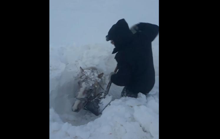
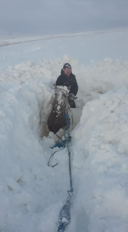
Snowstorms In Iceland Kill 80 Horses With Over 100 Still Missing
Report from Dec 18
The fate of over one hundred horses in Northwestern Iceland remains unknown following extreme weather conditions last week, RUV reports. Around the country, dozens of horses kept outside during last week’s storm perished. Many of the surviving horses are suffering from extreme exhaustion.
“There was no way to reach these horses for two or three days. The horses were completely out of sight. In such conditions, there’s nothing you can do, the horses being without food or water for all this time,” Sigríður Björnsdóttir, a veterinarian stated. According to Sigríður, last week’s storm was the most fatal natural disaster to have befallen Iceland’s horses in decades.

The Icelandic horse is renowned worldwide for its sturdy stature and thick coat that have evolved through centuries of harsh Icelandic winters. Despite this, no animal is immune when the weather is as extreme as it was last Tuesday and Wednesday.
Sigríður added that there was nothing to suggest that farmers had failed to take appropriate measures.
“These are traumatic events for the farmers, and I would like to emphasise that it’s not a matter of the farmers being unprepared. There’s nothing to suggest that. More often than not, for example, we see that a few horses have died on many farms, as opposed to many horses dying on a few farms. This is happening to experienced people. It isn’t a question of negligence. It’s simply the result of unprecedented weather conditions.”
The Icelandic horse is especially well suited to the outdoors: “The Icelandic horse has lived in Icelandic nature for centuries and is especially well suited to the outdoors all year round. The main benefit of being outside is freedom, where the horse’s natural behavior goes unimpeded. Their physical needs are also better served outside, especially as regards physical activity, which is a basic need among horses. The horses diet is often times more diverse if they are kept outside, enabling the horses to better regulate their body temperature, as they have a thick winter coat.”
Report from Dec 18
The fate of over one hundred horses in Northwestern Iceland remains unknown following extreme weather conditions last week, RUV reports. Around the country, dozens of horses kept outside during last week’s storm perished. Many of the surviving horses are suffering from extreme exhaustion.
“There was no way to reach these horses for two or three days. The horses were completely out of sight. In such conditions, there’s nothing you can do, the horses being without food or water for all this time,” Sigríður Björnsdóttir, a veterinarian stated. According to Sigríður, last week’s storm was the most fatal natural disaster to have befallen Iceland’s horses in decades.
The Icelandic horse is renowned worldwide for its sturdy stature and thick coat that have evolved through centuries of harsh Icelandic winters. Despite this, no animal is immune when the weather is as extreme as it was last Tuesday and Wednesday.
Sigríður added that there was nothing to suggest that farmers had failed to take appropriate measures.
“These are traumatic events for the farmers, and I would like to emphasise that it’s not a matter of the farmers being unprepared. There’s nothing to suggest that. More often than not, for example, we see that a few horses have died on many farms, as opposed to many horses dying on a few farms. This is happening to experienced people. It isn’t a question of negligence. It’s simply the result of unprecedented weather conditions.”
The Icelandic horse is especially well suited to the outdoors: “The Icelandic horse has lived in Icelandic nature for centuries and is especially well suited to the outdoors all year round. The main benefit of being outside is freedom, where the horse’s natural behavior goes unimpeded. Their physical needs are also better served outside, especially as regards physical activity, which is a basic need among horses. The horses diet is often times more diverse if they are kept outside, enabling the horses to better regulate their body temperature, as they have a thick winter coat.”
angelburst29
The Living Force
A severe cold snap killed at least 17 people in Afghanistan on Saturday, government officials said, as heavy snowfall and rain continued to lash parts of the country.
At least 17 killed as extreme cold sweeps across Afghanistan


Villages in most parts of Afghanistan received heavy snowfall due to plunging temperatures
Severe Cold Snap Across Afghanistan Kills At Least 17
Severe Cold Snap Across Afghanistan Kills At Least 17
January 12, 2020 - Heavy snowfall has closed many key roads since the New Year, including the Salang Tunnel connecting central Afghanistan with the north of the country, and the Kabul-Kandahar highway. Afghanistan's western province of Herat has also been hit badly.
On Saturday, heavy snow caused the roofs of two houses to collapse, killing at least eight people, including women and children, a spokesman for the province's governor said. Other parts of the country have experienced heavy rainfall.
"We're now expecting more cold waves in the coming weeks," said Mohammad Nasim Muradi, the head of the forecasting wing of the meteorological department.
At least 17 killed as extreme cold sweeps across Afghanistan
Villages in most parts of Afghanistan received heavy snowfall due to plunging temperatures
Severe Cold Snap Across Afghanistan Kills At Least 17
Severe Cold Snap Across Afghanistan Kills At Least 17
January 12, 2020 - Heavy snowfall has closed many key roads since the New Year, including the Salang Tunnel connecting central Afghanistan with the north of the country, and the Kabul-Kandahar highway. Afghanistan's western province of Herat has also been hit badly.
On Saturday, heavy snow caused the roofs of two houses to collapse, killing at least eight people, including women and children, a spokesman for the province's governor said. Other parts of the country have experienced heavy rainfall.
"We're now expecting more cold waves in the coming weeks," said Mohammad Nasim Muradi, the head of the forecasting wing of the meteorological department.