Unprecedented Rainfall and Major Flooding Around the World

Biblical downpours in Australia.


National cabinet documents obtained by Rex Patrick reveal increased risk of extreme weather events
Tropical cyclones and flooding are set to pummel Australia over summer, national cabinet documents reveal.

The Bureau of Meteorology briefed the meeting of premiers, chief ministers and the prime minister on 5 November about the high-risk weather facing the nation until April.

National cabinet documents are usually kept secret, but South Australian senator Rex Patrick obtained these under freedom-of-information laws.

Last week Patrick, the Labor leader, Anthony Albanese, and One Nation’s Malcolm Roberts all launched attacks on the prime minister’s department for its secrecy. There is a broader legal question about whether national cabinet is entitled to the cabinet-in-confidence protection, with critics saying that merely calling it a cabinet does not actually make it one

Emergency Management Australia’s director general, Joe Buffone, presented the 2021-22 High Risk Weather Season briefing.

The PowerPoint presentation shows there are increased chances of widespread flooding, coastal flooding and erosion, tropical cyclones and marine heatwaves, compared with average summers and early autumns.

There is a lower chance of drought and dust.

The overall risk of severe storms is on par with other years, while parts of Queensland and NSW have an increased risk of bushfire, and there is a higher chance of heatwaves than usual.

Warm waters mean slightly above average tropical cyclone numbers – the average is 11 per season.

La Niña means the weather is likely to be cooler, wetter and stormier. Areas that had above-average rainfall during spring, and therefore more grass, could lead to a heightened grassfire risk, while parts of the east coast will have a lower risk – because the 2019-20 fires reduced fuel loads.

The bureau’s presentation was prepared with publicly available information.


Patrick said the prime minister, Scott Morrison, should have released the documents when he released a media statement about the national cabinet meeting. That statement focused almost entirely on Covid, with a single line about the briefing.

That line prompted Patrick to make the FOI request to the Department of Home Affairs.

“These documents foreshadow risks to the Australian public over the coming months,” he said. “They were before national cabinet. Scott Morrison therefore has tried to keep them secret when the Australian public were entitled to know.”

In his FOI request, Patrick pointed to an August ruling in the administrative appeals tribunal that found cabinet confidentiality did not extend to national cabinet. Justice Richard White said national cabinet was not a subcommittee of the federal cabinet, as Morrison has claimed.

That decision could have paved the way for more documents to be released, but the government has rejected that finding as having no force.

“I specifically pointed them to Justice White’s ruling,” Patrick said.

He wrote that because of that ruling: “There is no requirement for the decision maker to consult with the Department of Prime Minister and Cabinet (PM&C) about the release of the requested documents.”

Home Affairs released the documents.

Patrick accused Morrison of being “addicted to secrecy”.

“The analysis is derived from publicly funded organisations,” he said. “It is about risks to the Australian public.”

Guardian Australia has contacted the prime minister’s office for a response.
REGRETTABLE: Strong #lluvias and dangerous #inundaciones in the north of #Malasia 🇲🇾 Report at least 12,000 people evacuated and State of Emergency due to flooding of the Sungai River #Malaysia #Flooding Track @Arab_Storms
 
Floods destroy homes in Australia 🇦🇺 March 2022 Brisbane, Queensland & New South Wales
I read here:

Frustration swelled among many flood-hit residents in Australia's east over slow relief and recovery efforts, as Sydney braced for more heavy downpours in the next two days that may trigger flash flooding and hamper current clean-up plans.

Thousands were forced to flee their homes after torrential rains since late last month brought widespread destruction in the states of Queensland and New South Wales (NSW), cutting off towns, and sweeping away farms, livestock and roads.

The death toll from the deluge rose to 18 after a man was found dead in a car swept away in floods in Queensland on Sunday.

"These are terrible, terrible floods," Prime Minister Scott Morrison told radio station 2GB on Monday. "These are floods that we have not seen in living memory in anyone's lifetime, and even before that. And so I can understand the great frustration (we are) seeing expressed."

More defence force personnel are being sent to flood-affected areas immediately to lead the recovery, said Morrison, who is trailing in polls ahead of a federal election due by May.

Residents have been taking stock of the damage over the weekend while struggling to clear debris and sludge after water levels receded in some places.

"We've had a week of no communications, no food, no fuel … it has been quite unnerving and emotional," a resident in the far northern NSW town of Murwillumbah, among the worst hit by record floods, told broadcaster ABC.

Power and internet are still down in several towns as emergency crews tried to clear roads to deliver essential supplies.

NSW Premier Dominic Perrottet, on a tour of the flood-hit regions, said the recovery could take years with about 2,000 homes deemed uninhabitable.

"The stories that we've heard, the sense of abandonment that many people had in devastating circumstances is heartbreaking, and we need to ensure it doesn't happen again," he said.

The Insurance Council of Australia on Monday estimated the current cost of claims from the floods at A$1.3 billion ($963 million). Insurers have to date received 86,703 claims, up 28% on Friday’s numbers, it said.

Rains have eased over the last two days but the weather bureau on Monday issued a 'severe warning' for parts of NSW, including state capital Sydney, as a second intense low-pressure system forms off the east coast in as many weeks.

The Bureau of Meteorology (BoM) forecast rains of up to 120 mm (5 inches) in Sydney on Monday and 150 mm Tuesday. Several suburbs have already received more than double March's mean rainfall of around 140 mm.

Australia's east coast summer has been dominated by the La Nina weather pattern, typically associated with increased rainfall, with many rivers already near capacity before the latest drenching.

"This additional rainfall on already saturated soils, catchments and flooded rivers, creeks and streams is giving us an increasing amount of concern," BoM meteorologist Dean Narramore said during a media briefing. "We are likely to see major flooding on numerous rivers."

I hope Australian forum members and their families are safe and doing okay!


When all else fails to grasp reality an Australian news service runs with the climate change agenda.

There has been a lot of discussion in the past fortnight about how rare the rain and flooding from this event was for Qld and NSW.

We already know that a number of records were broken for both rainfall and flooding, including those listed here, here and here. These are individual site records, where rain amounts, or flood heights, are the highest in official records for that location.

We can also use historical records and the observed rainfall and river level data from this event to calculate how unlikely it was for this type of rainfall or flooding to occur statistically.

A common way to represent this event probability is to use the Annual Exceedance Probability (AEP), which simply refers to the likelihood a given rain amount or flood height will occur in any given year.

Looking at the 676.8 mm of rain that fell in Brisbane during the 72 hours ending at 9am on February 28, the probability of this three-day rain rate in any given year is between 0.5 and 0.2 percent. Put another way, this much rain is, statistically, only expected to occur once every 200-to-500 years. This is because if there is a 0.5 percent probability of a given rain rate occurring in a given year, you would expect it to occur in one out of every 200 years.

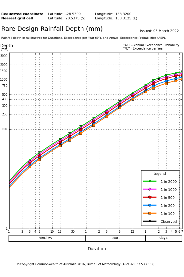
In northern NSW, Doon Doon’s 1040 mm during the 48 hours to 9am on March 1 was a rainfall rate that has a 0.1 to 0.05 percent chance of occurring in any given year. This makes it fall somewhere between a 1-in-1000 year and 1-in-2000 year rainfall rate for this site.

doon_doon_depths_rare_bom.png

Image: Annual exceedance probabilities of various rainfall rates and durations at Doon Doon, NSW. The black dot represents the observed rate of 1040mm in 48 hours, which sits between the pink (1-in-1000) and green (1-in-2000) lines. Source: Bureau of Meteorology.


However, it is important to note that these estimated return intervals are not schedules, they are probabilities. A 1-in-1000 year rain rate is not a rain rate that occurs only once every 1000 years. It is, instead, a rain rate that has a 0.1% chance of occurring at that location in any given year.

It is possible to have 1-in-1000 year rain rates in two consecutive years. In some parts of the world, climate change is making extreme rain events more frequent and intense. So, what used to be a 1-in-1000 year event in a past climate may now be more like a 1-in-100 year in the modern climate, for some places.


This Tuesday a landslide was recorded in Peru in the mining area of the province of Pataz due to the intense rains of recent days. In statements to TV Peru, the regional governor of La Libertad, Manuel Llempen, said that the phenomenon left between 60 and 70 houses buried.
President Pedro Castillo announced on his Twitter account that the head of Indeci and the Minister of Defense will travel to the affected area. “We will support the affected families and we will coordinate various actions with the local authorities,” he wrote.


REGRETTABLE: The tragedy is repeated in #Petropolis #Brasil Yesterday, Sunday in Petrópolis, a mountainous area of #RíodeJaneiro heavy rains left 118 millimeters in less than 1 hour causing floods and dangerous floods Track @tucamaiacaetano

The rainy episode started on Sunday on #LanguedocRoussillon ends.
Accumulation recorded on the episode: 154 mm in Castanet-le-Haut (34) 136 mm in Cabrerolles (34) and Perthus (66) 99 mm in St-Pons-de-Thomières (34) http://meteofrance.com

Parts of Queensland and NSW could be hit with heavy rain later this week, raising the risk of more flooding in already saturated river catchments.
A slow-moving upper-level trough interacting with moisture-laden air will allow rain and storms to develop over eastern Australia from Wednesday or Thursday this week.

This wet weather pattern has the potential to linger through the weekend and into the start of next week, potentially fuelling a multi-day rain event over parts of Queensland and NSW.

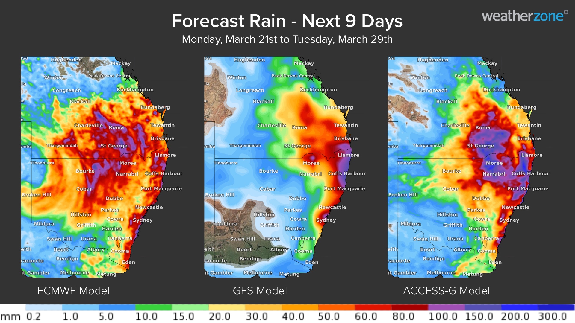
It is too early to know exactly how this dynamic weather event will unfold, which means it is not yet possible to predict where and how much rain will fall. The maps below show this uncertainty by comparing forecast rainfall during the next nine days from three different computer models.

next_9_days_20220321%20copy.jpg


Image: Forecast accumulated rain during the next nine days according to the ECMWF-HRES (left), GFS (centre) and ACCESS-G (right) models.

While there are some similarities between the three maps above, there is notable disagreement in terms of how much rain will fall and where the heaviest rain will land.

Broadly speaking, anywhere from central Queensland down to southeast NSW could be affected by heavy rain between the middle of this week and the middle of next week.

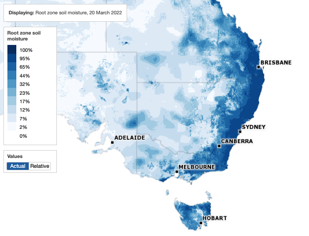
Any rain that falls on or east of the Great Dividing Range in NSW or southeast Queensland will be hitting already saturated soil, increasing the likelihood of flooding.

soil_moisture_20220321.png


Image: Root zone soil moisture on March 20, 2022. The root zone is defined as the top 1 metre of the soil profile. Source: Bureau of Meteorology.

More reliable forecasts will become available as the week unfolds. Anyone living between central Queensland and southern NSW should keep an eye on the latest forecasts and warnings for more up-to-date information.

 
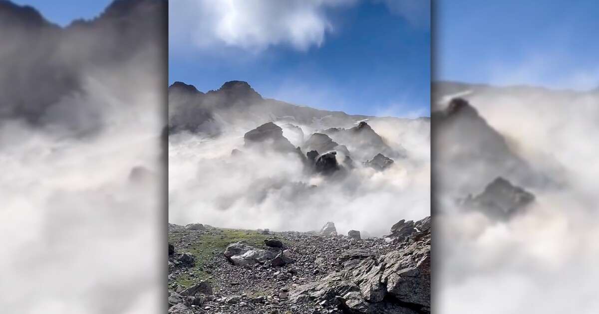
Apartment-sized boulders cascade in a sudden landslide at Rocky Mountains National Park in Colorado.

The rockslide was reported on the south shoulder of Hallett Peak in RMNP
Posted at 12:18 PM, Jun 29, 2022 band last updated 5:18 PM, Jun 30, 2022 Snip / Video
ROCKY MOUNTAIN NATIONAL PARK, Colo. — As the group of four men ran down the rocky southern shoulder of Hallett Peak on Tuesday afternoon in their climbing shoes, they looked back to see rocks the size of an apartment crushing where they had been climbing a few minutes earlier.Jeremy Fullerton, 31, of Boulder and his three friends — William Mondragon, Levi Van Weddingen, and

Mike Vice — climb in Rocky Mountain National Park often. Fullerton said he enjoys bouldering around Hallett Peak and its Upper Chaos Canyon. He's visited that area roughly 40 to 50 times a year since he moved to Colorado nine years ago.

The friends would lug large foam mats up the slopes and climb up giant boulders that previously fell off the mountain. At the end of an attempt, they simply let go and fall on the mat.For the average national park visitor, Hallett Peak may be more familiar from its eastern face, which looms above the west side of Dream Lake (the left side when reaching the lake from the Bear Lake Trailhead).

"So yeah, we were just out for a normal day of climbing and then it kind of got a little crazy obviously, with all the rockfall that happened," Fullerton said.

Every year, the area goes through a freeze-thaw period as snow melts off the cliffs. He said it's not uncommon to see large rocks — sometimes the size of cars or even houses — fall off that shoulder of Hallett Peak a couple times a day.

On Tuesday afternoon, they saw that the rocks were a bit more "active" than normal, he said. They had even paused a few times throughout the day to watch the rockfall from a safe distance.

Around 4:30 p.m., Fullerton took a turn climbing a boulder in a cave as his friend Mondragon took a video. Fullerton's three friends were quiet — which is custom in climbing — as he carefully navigated the rock.

"But my friend Mike and Levi were outside of the cave, and they just start screaming and being like, 'Oh my God, the top just fell off.' And just like freaking out," Fullerton said.

Fullerton let go of the boulder and fell on his mat.

"We ran outside the cave and sure enough, within five minutes, we were essentially running for our lives away from the rockfall area because if we stayed where I was just climbing five minutes ago, we would have died for sure," he said.

They abandoned their gear and ran downhill in climbing shoes.

The rockslide was reported on the south shoulder of Hallett Peak in RMNP

Every year, the area goes through a freeze-thaw period as snow melts off the cliffs. He said it's not uncommon to see large rocks — sometimes the size of cars or even houses — fall off that shoulder of Hallett Peak a couple times a day.

On Tuesday afternoon, they saw that the rocks were a bit more "active" than normal, he said. They had even paused a few times throughout the day to watch the rockfall from a safe distance.

Around 4:30 p.m., Fullerton took a turn climbing a boulder in a cave as his friend Mondragon took a video. Fullerton's three friends were quiet — which is custom in climbing — as he carefully navigated the rock.

"But my friend Mike and Levi were outside of the cave, and they just start screaming and being like, 'Oh my God, the top just fell off.' And just like freaking out," Fullerton said.

Fullerton let go of the boulder and fell on his mat.

"We ran outside the cave and sure enough, within five minutes, we were essentially running for our lives away from the rockfall area because if we stayed where I was just climbing five minutes ago, we would have died for sure," he said.

Hmm... 🤔 Chaos Canyon.


Landslide in Peru: the moment when a hill collapses and buries 150 houses

According to what has been announced by the authorities, so far it is not known if there are any victims

Defense Minister Jose Gavidia told public television in the evening that the fall of large masses of earth occurred around 18:00 local time in the remote town of Chavin de Huantar, located more than 270 kilometers northeast of the capital.

"The initial report we have is of at least 150 homes affected. It is dark and we have sent the first brigades,'' he said, adding that more than 50 soldiers have already been sent to the site to help in the removal of debris around the Cruz de Shallapa hill.

#Peru: Panic and despair after the landslide of the Cruz de #Shallapa hill in Chavín de Huántar, in #Áncash. Preliminary reports indicate that more than 150 homes were buried...
 
In Northern Italy, a sudden glacier gave way due to warmer temperatures in #Marmolada

A section of the Alpine glacier of the #Marmolada ( #Italie ) broke off this afternoon. The provisional toll reports at least 5 dead and 8 wounded.

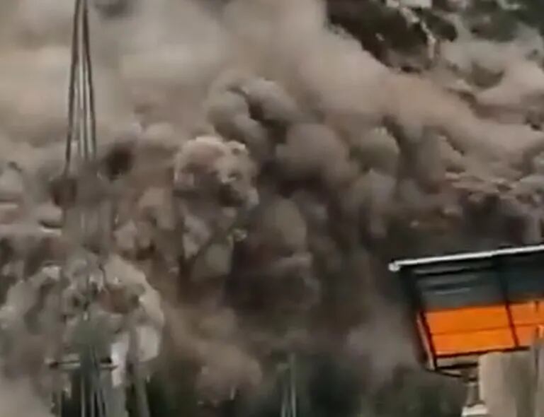
India in the Batseri, Kinnauri district

India
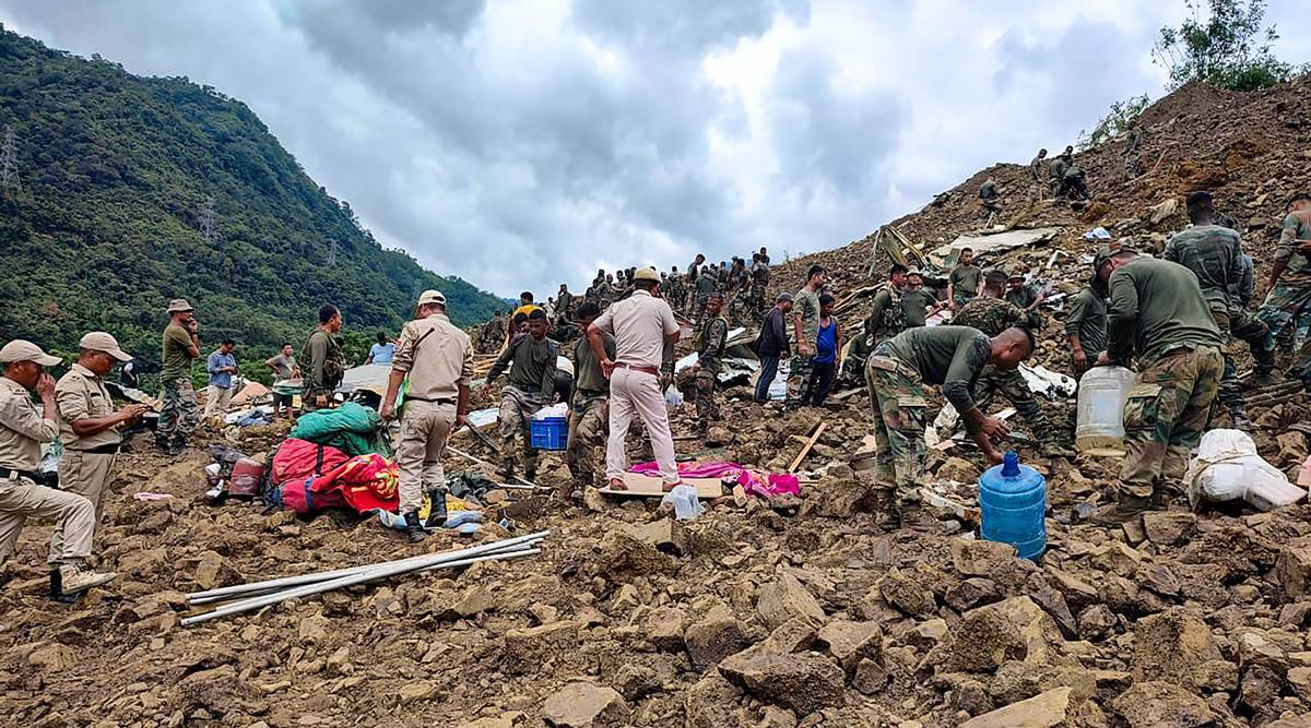
Videos from South Garo Hills... Rain is just the trigger. If you notice the trees are mostly #Plantation trees, Betel Nut... Once these hills were thickly covered with multi species trees.
 
Back
Top Bottom