Unprecedented Rainfall and Major Flooding Around the World


Heavy rains and high water levels in Beish GovernoratePhotographed by Al-Mutarid: Mesdaf Abu Al-Fadael#جازان_الان


Watch out for the next few days on the Peninsula. The atmosphere is going to teach us a lesson that droughts are not gestated in two months, nor are they solved in a week. Meteorological times are too long for journalistic deadlines... Someone is going to have to change rattles.


Screenshot 2023-05-21 at 19-56-23 Reed Timmer PhD on Twitter.png

Screenshot 2023-05-21 at 19-28-57 Gaétan Heymes on Twitter.png
L-1 At Château Queyras, the water level is derisory but by propagation the Guil is still tumultuous. The flood peak has not passed but its level remains very far from that of the flood of June 2000: we can guess the flood marker on the right of the scale.4/6
L-3 The propagation of the flood wave from the Guil on the Durance can also be seen on the Vigicrues graphs.At Argentiere, upstream of the confluence, the flow of the Durance stagnates.In Embrun, downstream, it has already increased by 15m³/s.6/6
 

Strong storm in progress between Aude and Ariège julienrib 11

The #orages will resume intensity tomorrow morning in the southeast and will spread to the southwest in the afternoon. They will again be quite strong with the risk of runoff, be careful in the car

In #Provence , rainfall accumulations were very heterogeneous in May. Frequent and very rainy #orages gave more than 200 mm in Haute-Provence in Aups while the monthly rainfall was only 25.8 mm in Arles and 26.8 mm in Sanary-sur-mer on the Var coast.


#CAwx 5/30/2023
Screenshot 2023-05-30 at 20-44-28 #CAwx - Twitter Search _ Twitter.png
Screenshot 2023-05-30 at 20-49-33 Pyrénées Orages - B.Bucheli on Twitter.png
 
Flash Flood Emergencies covering over 100,000 people, stretching from Pensacola through Warrington and Myrtle Grove as spotter reports to the National Weather Service indicate flooded roads and homes with waters rising.


PENSACOLA, Fla. — Life-threatening flash flooding swept across swaths of Pensacola, Florida early Friday morning as deadly severe thunderstorms dumped several inches of rain and brought a possible tornado, leaving one person dead and parts of the region buried under feet of water.

Flash Flood Emergencies covered over 100,000 people, stretching from Pensacola through Warrington and Myrtle Grove as spotter reports to the National Weather Service indicated flooded roads and homes with waters still rising in some areas.

"Life-threatening flooding ongoing in Warrington, Downtown and West Pensacola with likely well over 1 foot of rainfall falling," The National Weather Service in Mobile warned. "Flash flooding is also likely occurring across most of the metro Pensacola area."


The NWS estimates some areas have received 8-15 inches of rain over just several hours, with more rain likely to fall through the morning. A rain gauge in Gulf Breeze reported 14.08 inches in 6 hours while Pensacola airport reported 9.23 inches of rain in a 5-hour period.

"Extremely busy night for us," said Deputy Fire Chief Paul Williams with Escambia County Fire. "There's been numerous water rescues, flooding condition calls, rescuing folks from their houses or their cars when they're driving through some intersections that are submerged with water."

One found dead after tree falls into Florida home

Emergency officials are reporting multiple water rescues across the Escambia County, including evacuating 143 residents from a flooded apartment building.

"It's submerged to the point where it's almost over the top of vehicles in the back there," Williams said about the building's backyard, which sits along a creek. "So it's about chest deep water in the very back of the complex."


In addition to the heavy rains, the storms brought ferocious winds amid a possible tornado that downed trees and power lines and left a trail of other damage. Williams reports one person died when a tree fell into a home.

"We've got numerous reports of limbs down, power lines down, possible tornado touched down," Williams said. "So there may very well be some debris over in that area to please be careful as you get out. There still be some standing water in some areas."

About 8,000 people are without power in the area.

The Flash Flood Emergency expired just after 6:30 a.m. CT but more rain was expected later in the day.
 

Australia 👀
Severe Weather Update: Widespread rain continues and extensive flood watches
Tuesday, 27 June 2023.
Senior Meteorologist Miriam Bradbury is current at 1:00 pm


Biblical proportions of rain reported in Chile

DATA UPDATE Final update of accumulated rainfall in the last 120 hours, after this rainy weather event with a high 0°C isotherm, between #Valparaíso and #Araucanía .
 

Attachments

  • Screenshot 2023-06-27 at 09-50-45 Severe Weather Update Unseasonable rainband for northern and...png
    Screenshot 2023-06-27 at 09-50-45 Severe Weather Update Unseasonable rainband for northern and...png
    833.3 KB · Views: 5
CHINA / SOCIETY By Global Times Published: Feb 23, 2023 01:52 PM

Update: Six found dead, 47 missing after massive accident in N.China’s Inner Mongolia

Coal mine collapse under investigation; related personnel controlled

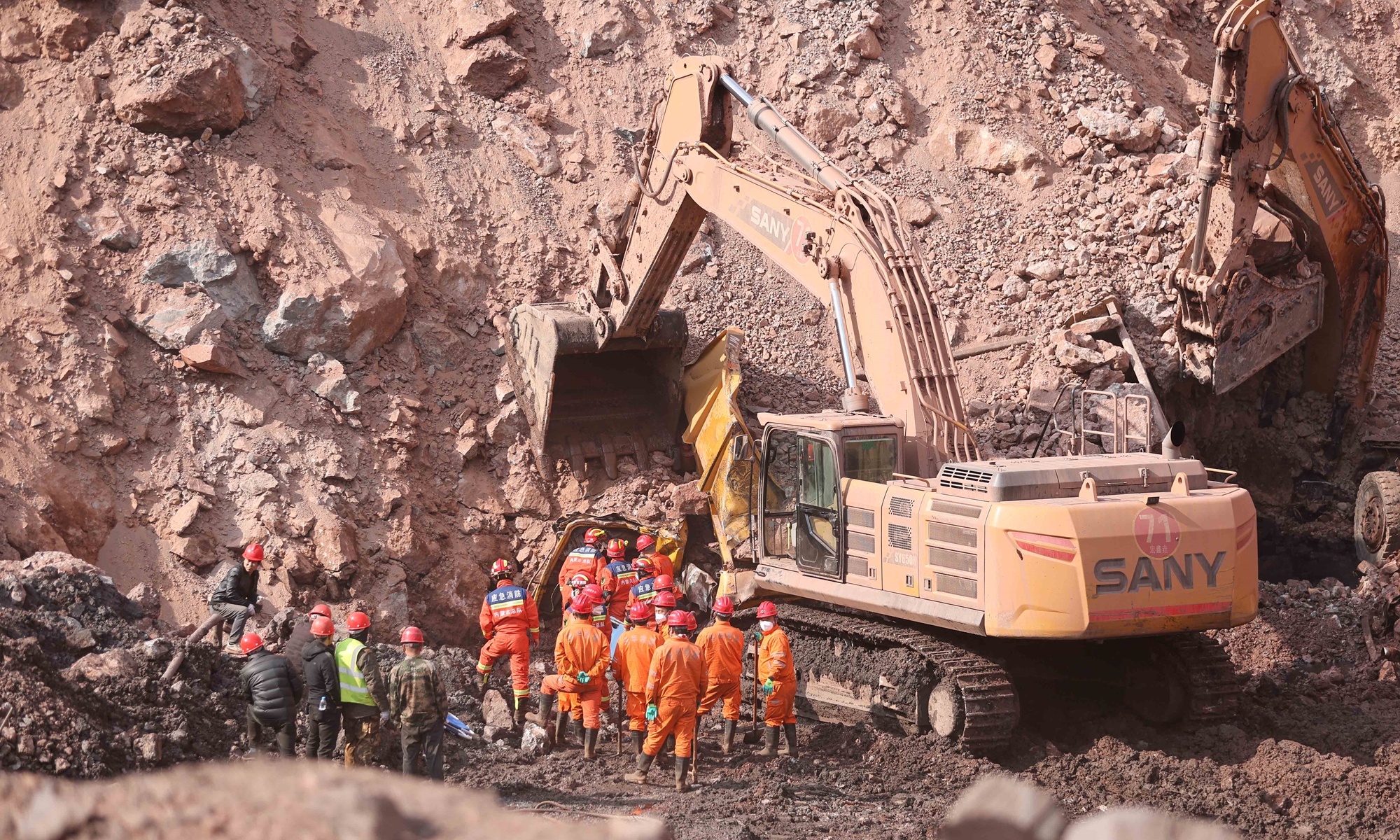
Rescuers on the site of the collapsed coal mine in Alxa league, North China's Inner Mongolia on February 23, 2023. Photo: Xinhua

Rescuers on the site of the collapsed coal mine in Alxa league, North China's Inner Mongolia on February 23, 2023. Photo: Xinhua

Rescuers recovered one more victim from the debris, bringing the total deaths to six with 47 missing as of Thursday night, after a massive open-pit coal mine collapsed in North China's Inner Mongolia Autonomous Region on Wednesday. China's Ministry of Emergency Management ordered a full rescue and thorough investigation of the cause of and responsibility for the accident.

The coal mine in Alxa Left Banner, Alxa league, Inner Mongolia, collapsed at around 1 pm Wednesday. An employee told media on Wednesday that the mine had about 600 employees.

National broadcaster CCTV reported that the specific cause of the collapse is under further investigation. As the public security organs have become involved in the investigation, the relevant personnel have been put under control, and the follow-up will be announced in due course.

CCTV reported that the six people rescued on Wednesday were receiving treatment at a hospital in Qingtongxia, Northwest China's Ningxia Hui Autonomous Region, and their conditions were not life-threatening.

Ma Jianping, one of the injured, was quoted by the report as saying that at around 1:15 pm on Wednesday he found that the slags were falling from the mountain, and then saw that the situation was more and more serious. Although they were immediately organized to evacuate, it was too late to leave before the collapse.

Through overnight investigation and assessment, the expert group on Thursday developed an optimized rescue plan, and all search and rescue personnel, medical staff and ambulances were in place.

Wang Xiangxi, minister of emergency management, arrived at the scene at 1 am Thursday, inspected the site in detail and learned about the rescue and disposal situation. Wang said the rescue work must be carried out in full force, according to the official statement released by the Ministry of Emergency Management on Thursday evening.

The ministry urged the investigation to be carried out seriously and pursue responsibilities in accordance with the law.

As of 6 am Thursday, more than 900 personnel had rushed to the site for rescue operations, the Xinhua News Agency reported.

Experts from the central authorities, the autonomous region and other relevant provinces and regions had arrived at the rescue site.

The rescue operation is complex, as the mining area is located within a valley. After the collapse, the bottom of the operation surface was basically buried.

The incident occurred in the western section of the coal mine. The mountain slope in the western mining area collapsed. After the collapse, it formed a mound of dirt that ran 500 meters east to west and 200 meters north to south.

Video footage from the mine's cameras showed that the collapse occurred at around 1 pm and lasted for about 30 to 40 seconds. At about 6:44 pm, a second major landslide occurred at the site and halted search and rescue efforts.

In order to ensure the safety of the rescue workers, according to the advice of the expert group, all the rescue workers and vehicles were then evacuated to a safe area. The expert group carried out on-site assessments overnight, formulated an optimized rescue plan, and then organized the rescue.

All the rescue forces have been put in place, medical rescue forces and ambulances have been prepared, and the power supply and communication support for the on-site emergency command has been put in place.

The mine was originally a closed site, but in 2012 it was transformed into an open-pit mine. Production resumed in April 2021 following a three-year suspension.

Wang Hongwei, a professor at the Renmin University of China's School of Public Administration and Policy, told the Global Times on Thursday that as the area of the collapse almost covered the whole slope of the mine, removing the large amount of earth in the short term would be very challenging.

Plus, the collapsed area is located in a V-shaped valley, so there was less opportunity for miners to escape, and rescue teams had limited scope to launch their work, Wang noted.

But when the collapse occurred, many miners might have been operating excavators and dump trucks. In this case, many buried personnel may be in the interiors of the carriages, and the cabs of the carriages can form a space of shelter, which may increase the possibility of survival for those who were buried, he said.

He said an open-pit mine is usually less likely to have an accident than an underground mine. Although the specific cause of the disaster remains unknown, if the monitoring of the slope is strengthened, the possibility of the occurrence of such emergencies would be reduced and the risk can be effectively controlled, said Wang.

Some observers believe there may have been man-made factors to this disaster, such as overexploitation of the mountain, which caused a structural imbalance, thus leading to the collapse.

The Global Times found the company had been put on China's credit blacklist.
 
Jul 2, 2023 Updated 6 hrs ago
Denver has two new record amounts for rainfall in the month of June, and the numbers are sizeable.

Denver broke June's rainfall record by recording a whopping 6.10 inches at the city's official weather station at Denver International Airport, according to the National Weather Service in Boulder. The old record of 4.96 inches, set in 1882, is 1.14 inches less than the new record.


The second new record for greatest 24-hour total of rainfall for June 2023 fell between June 21-22, measuring 1.89 inches, with 1.85 inches of that total falling on June 21. The 1.85 inches of rainfall was a daily maximum record, according to the NWS, breaking the old record of 0.85 inches set in 1947.

June 2023 also was the 6th wettest month of all time in Denver's recorded weather history; dating back to 1872. June averages 1.94 inches of rainfall, but June 2023 was 4.16 inches above average.

Combining May and June totals from DIA, 11.63 inches of rainfall was recorded, or 7.53 inches above the combined average for the two months.

Screenshot 2023-07-03 at 09-47-11 June 2023 saw record rainfall for Denver but just how much f...png

How much snow would that have been? Using a water equivalent ration of 10:1, Denver would have recorded 61 inches of snow, or five feet. According to the NWS, Denver recorded 0.5 inches of snow in June 1953, the last year more than a trace of snow was recorded.

June 2023 was also cooler than previous months, having only one recorded daily high above 90, which happened on June 27 when the mercury topped 92 degrees.

The average June temperature is 68.2 degrees, and June 2023 was 4.0 degrees cooler at 64.2 degrees, but still not in the top 20 coolest Junes in Denver history.

As July begins, the city can also experience heavy rainfall totals for the month.

The National Oceanic and Atmospheric Administration forecasts a wetter conditions across several states, including parts of eastern Colorado, for the month of July.

1688370677664.png

On July 30, 1997, Denver recorded a maximum daily rainfall record of 2.71 inches. The other top five maximum daily rainfall records are: July 25, 1998 - 2.69 inches, July 31, 1919 - 2.59 inches, July 10, 1998 - 2.35 inches and July 28, 1910 - 2.21 inches.

Here are the top 10 wettest Julys in Denver's recorded history:
  • 6.41" - 1965
  • 5.92" - 1998
  • 5.60" - 1997
  • 5.24" - 1919
  • 4.76" - 2001
  • 4.28" - 1895
  • 4.17" - 1956
  • 4.17" - 1909
  • 4.17" - 1875
  • 4.11" - 1991
July is also the warmest month on average in Denver, with a low- to high-temperature range between 58-88 degrees. The warmest average daily low- to high-temperature range is from July 17-22, with temperatures average from 61 to 91 degrees; the hottest period of the year.

July 20, 2005 saw a record high of 105, and from July 20-23 the high temperature reached 102 or higher each day.

Chicago
 
Mexico flooding from the passing of Hurricane #Beatriz

Flooding and dangerous currents were generated to the west of #CDMX by the heavy storm/rain this afternoon-night. Thus, on the Pichacho-Ajusco highway at the height of Boulevard de La Luz and the intersection with Periférico Sur. Wednesday to Thursday, stronger storms! @TlalpanVecino and @grawperez


Screenshot 2023-07-05 at 13-36-52 Storm Chaser Corey Gerken on Twitter.png

Storm-poly hammerers Amsterdam! One of many Pics.
Screenshot 2023-07-05 at 14-10-25 📢 DAF on Twitter.png
 

Pennsylvania


Last edited:
A new study by First Street Foundation shows that 1-in-100 year floods are starting to happen a lot more frequently.
Seriously? SOTT has been reporting on the crazy weather going on, including year after year of huge flooding all over the world, since 2014. Now, someone has noticed and done a new study showing this? Amazing how up-to-speed they are with all of this.

Sorry for the rant.
 
Austria.

Interesting, I I did not know about this type of landslides.

Yesterday's unprecedented wind-induced #landslide uprooted old and large spruce and larch trees in an extremely steep NW slope of the Zollberg at 1600 m asl in Jerzens/Tirol, AT due to the very strong and gusty winds. [1/7]

Minutes after the first detachment a second partition breaks off higher up. The extreme dust plumes visible in the video show that in this very dry slope much of the sediment displacement is actually happening through the air! [2/7]

For those curious here are the coordinates [3/7]

And a nice before and after as seen from the village. [4/7]

Local forest rangers had a drone inspect the damage today. (c) BFI Imst [5/7]

They reported that the gusts travelled further south into the Pitztal valley causing further damage mostly on the other side of the valley. Destructive like a debris flow in a channel. (c) BFI Imst [6/7]

They reported that the gusts travelled further south into the Pitztal valley causing further damage mostly on the other side of the valley. Destructive like a debris flow in a channel. (c) BFI Imst [6/7]


Similar observations in Ochsengarten/Tirol, AT in Oetztal just one valley away in similar altitude regime. [7/7]
 
Screenshot 2023-07-28 at 23-01-15 Ruben H on Twitter.png

On July 28, the Paris station totaled 48.1 mm of rain! We have to go back more than 5 years to find a higher daily total in the capital (78.2 mm on 06/11/2018)!

It's a deluge in Paris where 24 mm of rain fell in just over 30 minutes (36 mm since this morning)! Water rushes down the stairs of Montmartre. ( © Marie-ange Vingadassalom)


Opinion: The Good, the bad, and ugly


Trending content

Back
Top Bottom