Earthquakes around the world

Very near to Teheran. Human Cosmic Connection, big bomb, natural event?
Natural event, latest from TasnimNews Telegram Channel
Dispatching assessment teams to earthquake-hit villages

Crisis Management:
🔹 According to the report received, due to the dispatch of expert assessment teams, no reports of damage have been received so far.

🔹 Also, a 2.5-magnitude aftershock has been recorded at 21:34 by the Geophysics Institute of the University of Tehran.
 
WORLDWIDE EARTHQUAKE REPORT JUNE 23_2025

A very strong magnitude 6.2 earthquake occurred in the Philippine Sea 364 km (226 mi) from Philippines

M 6.2 - east of the Philippine Islands
2025-06-24 01:58:05 (UTC)
7.988°N 129.859°E. 5.0 km depth
USGS earthquake alert
chrome_screenshot_23 jun. 2025 11_50_02 p. m. CST.png

A strong magnitude 5.7 earthquake occurred in the North Atlantic Ocean near the coast of Dominican Republic.

M 5.7 - 77 km NNE of Punta Cana, Dominican Republic
2025-06-24 02:45:43 (UTC)
19.225°N 68.110°W. 68.0 km depth
USGS earthquake alert
chrome_screenshot_23 jun. 2025 11_54_29 p. m. CST.png

Previous cluster on June 23

M 5.3 - 80 km ESE of Kimbe, Papua New Guinea/ 2025-06-23 03:17:16 (UTC) USGS
M 5.1 - 106 km N of Tatsugō, Japan
2025-06-23 14:36:19 (UTC) USGS
M 5.0 - 108 km NNW of Tatsugō, Japan
2025-06-23 17:23:29 (UTC) USGS
M 5.0 - 189 km ESE of Kimbe, Papua New Guinea/ 2025-06-23 18:51:53 (UTC) USGS
M 5.4 - 31 km NNW of Asan-Maina Village, Guam/ 2025-06-23 19:14:26 (UTC) USGS
M 5.5 - 105 km SE of Kirakira, Solomon Islands/ 2025-06-24 01:58:41 (UTC) USGS

SSGEOS forecast updated 22 June 2025, 10:55 UTC
Lunar geometry on the 22nd and 23rd can result in clustering of stronger tremors, mostly in the higher 5 magnitude range. A mid 6 magnitude earthquake is possible on the 23rd or 24th.

New observation period from June 22 to 30
2025-06-21-overview.png

During the last observation period from June 12 to 21, four earthquakes measuring M6.1 were recorded.
2025-06-12-overview (1) (1).png
 

Attachments

  • 2025-06-12-overview (1) (1).png
    2025-06-12-overview (1) (1).png
    135.1 KB · Views: 0
A very strong magnitude 6.1 earthquake occurred in the Philippine Sea near the coast of Davao, Philippines.

M 6.1 - 71 km ESE of Sarangani, Philippines
2025-06-27 23:07:10 (UTC)5.277°N 126.098°E101.6 km depth
USGS earthquake alert
chrome_screenshot_27 jun. 2025 7_36_37 p. m. CST.png

The situation so far.

M6.1 in Philippines can be related to several lunar geometries that occurred between June 25 and 26. According to an update from SSGEOS made on June 25, these lunar geometries can result in clustering of stronger tremors.​
2025-06-21-overview.png

A critical planetary alignment involving Mars, Mercury, and Neptune will occur tomorrow June 28 around noon. This could lead to a significant event around June 30.​
 
WORLDWIDE EARTHQUAKE REPORT JUNE 28_2025

Very strong mag. 6.6 Earthquake - South Atlantic Ocean, 307 km east of Valette, isla Island, Antarctica.​

M 6.6 - Scotia Sea
2025-06-28 08:32:21 (UTC)
60.958°S 38.947°W. 10.0 km depth
USGS earthquake alert
chrome_screenshot_28 jun. 2025 8_51_52 a. m. CST.png

The energy of the M6.6 earthquake could result in a worst-case scenario with another earthquake of the same magnitude in the south-central region of Chile, although events in the Sandwich Islands or the Indian Ocean cannot be ruled out.​

Other seismic events ≥M5.0

M 5.1 - 200 km W of Oula Xiuma, China
2025-06-27 04:25:53 (UTC) USGS
M 5.0 - 271 km SSE of Port Blair, India
2025-06-27 14:58:23 (UTC) USGS
M 5.5 - 165 km NNW of Houma, Tonga
2025-06-28 04:17:09 (UTC) USGS
M 5.2 - 170 km S of Nikolski, Alaska
2025-06-28 06:08:19 (UTC) USGS
M 5.1 - 285 km NW of Chokurdakh, Russia
2025-06-28 09:51:30 (UTC) USGS
M 5.3 - 138 km NW of Tobelo, Indonesia
2025-06-28 12:40:43 (UTC) USGS

The situation so far
2025-06-21-overview.png

Strong seismic activity will continue in the coming days. On June 30, the next critical planetary geometry involving Mercury and Venus with Neptune will occur. This configuration also tends to result in significant events.
● SSGEOS Earthquake forecast: updated June 28, 2025, 10:55 UTC
⚠ EARTHQUAKE WARNING ⚠
A sequence of critical planetary and lunar geometry from June 28 to 30 may result in very strong to major seismic activity, potentially reaching a high magnitude of 7 or higher. Be on extra alert if you are in an earthquake-prone area.
 
USGS reports 5.3 magnitude earthquake in central Pakistan
A 5.3-magnitude earthquake strikes central Pakistan, according to the USGS
An earthquake of magnitude 5.3 struck central Pakistan, the U.S. Geological Survey (USGS) reported Sunday morning. There is no information yet on casualties or damage.
The earthquake occurred Sunday around 03h30 (00h30) at a depth of 10 kilometers. The epicenter was about 150 kilometers west of the city of Multan. Around 60 kilometers (37 miles) north-northeast of Barkhan, a city in Pakistan’s mountainous Balochistan province.

Event summary

This earthquake can have a low humanitarian impact based on the magnitude and the affected population and their vulnerability.
GDACS ID
Earthquake Magnitude:
Depth:
Lat/Lon:
Event Date:
Exposed Population:
Inserted at:
INFORM Coping capacity:
[td width="265.438px"]EQ 1487918[/td] [td width="265.438px"]4.5M[/td] [td width="265.438px"]10 Km[/td] [td width="265.438px"]30.3299 , 69.9739[/td] [td width="265.438px"]29 Jun 2025 02:32 UTC
29 Jun 2025 07:32 Local
[/td]
[td width="265.438px"]
50 thousand in MMI IV
[/td]
[td width="265.438px"]29 Jun 2025 03:42 UTC[/td] [td width="265.438px"]5.7 (Pakistan)[/td]
1751230337027.png
 
WORLDWIDE EARTHQUAKE REPORT JUNE 30_2025

Moderate seismic activity on June 28 and 29; seismic cluster has recorded 11 earthquakes ≥M5.0 so far.

M 5.1 - South Sandwich Islands region
2025-06-28 18:18:20 (UTC) USGS
M 5.1 - 31 km SSW of San José, Guatemala/ 2025-06-28 19:35:21 (UTC) USGS
M 5.3 - 56 km NNE of Barkhan, Pakistan
2025-06-28 22:24:00 (UTC) USGS
M 5.4 - 100 km NNW of Tatsugō, Japan
2025-06-29 01:15:25 (UTC) USGS
M 5.1 - south of Panama
2025-06-29 05:46:35 (UTC) USGS
M 5.1 - 157 km SSW of Lorengau, Papua New Guinea/ 2025-06-29 06:48:09 (UTC) USGS
M 5.2 - 103 km N of Tatsugō, Japan
2025-06-29 07:11:56 (UTC) USGS
M 5.2 - south of the Fiji Islands
2025-06-29 22:27:39 (UTC) USGS
M 5.1 - 280 km SSE of Port Blair, India
2025-06-30 04:39:02 (UTC) USGS
M 5.0 - 282 km SSE of Port Blair, India
2025-06-30 05:52:21 (UTC) USGS
M 5.2 - 98 km NNW of Tatsugō, Japan
2025-06-30 09:33:22 (UTC) USGS

According to the SSGEOS forecast, there is an 80% probability of an earthquake of up to M6.4 in the worst case scenario, but an event that could exceed M7.0 cannot be ruled out, in which case the probability is 70%. The probability of an ≥ M8. 5 is 50%. This is due to the planetary geometry of Mercury, Venus, Neptune, and the lunar geometry of Earth, Moon, Mars.

2025-06-21-overview.png

SSGEOS mentions: "these are the ingredients for a very large seismic event, easily M7. We could have one or two M7 earthquakes in the worst-case scenario. It depends largely on the stress levels in the Earth's crust or whether the faults have reached a tipping point."

"This type of planetary and lunar convergence can trigger significant seismic activity. If we look at the records, in 1960 there was an M9.5 earthquake and in 1964 a M9.2 earthquake, both of which coincided with a lunar geometry with Mars."

The most critical moment is June 30, but especially July 1 or 2. On July 2, new lunar conjunctions will occur again. Therefore, if you are in areas prone to earthquakes, stay alert. Have a plan. We don't know where it could happen. Some areas that have recorded atmospheric fluctuations:

2025-05-28a.jpg
2025-06-17a.jpg
2025-06-17aa.jpg
 
Campi Flegrei, Napoli - Italy
30 June 2025

A stronger earthquake that went unnoticed here, the strongest in the area in many years (on par with the 13 March 2025 earthquake, e.g. also M4.6).


campi02.jpg
View over the earthquake region in the west of the Campi Flegrei. Pennata in the center of the image. © Marc Szeglat

Earthquake measuring 4.6 on the Richter scale in the west of the caldera


The Campi Flegrei (Phlegraean Fields) in southern Italy were shaken by a relatively strong earthquake measuring 4.6 on the Richter scale at 12:47:11 p.m. (CEST) today. The epicenter was located off the coast of Bacoli in the west of the caldera. The focal depth was determined to be 4.9 kilometers. The data comes from the INGV and is only a few minutes old. Therefore, it may still be corrected.

cf00001.jpg

Earthquake Md 4.6. © INGV [this is the corrected location i inserted above]

Several aftershocks followed, including one with a magnitude of 2.2 that occurred 4 minutes after the main quake. The EMSC has only reported this tremor so far.

Together with the quake of equal strength on March 13, this quake is the strongest ever measured in the caldera. This is the first time such a strong quake has occurred off the coast of Baccoli. It is still unclear whether there was any damage there. The municipality of Pozzuoli gave the all-clear and said that, according to initial observations, no damage had occurred. Nevertheless, the mayor's office issued a statement on the tremors and again published contact details where citizens can report damage.


campi01.jpg

Rockfalls on Pennata

People fled buildings – schools were evacuated
The earthquake came at an inopportune time for many high school seniors, as oral exams were being held at some high schools in the Naples area. Since schools are evacuated at short notice in the event of noticeable earthquakes, all students had to leave the buildings, interrupting the exams.
According to initial media reports, there were also mass evacuations beyond schools and public buildings, as thousands of concerned citizens left buildings after the strong tremor and fled to streets and squares.

Near Capo Miseno, in the far southwest of the caldera, rockfalls occurred on the cliffs of the small island of Pennata, which borders a bay that forms a natural harbor. This is where the Campanian ignimbrites, which were formed during the caldera-forming eruption 39,000 years ago, are exposed. Images show rock dust being stirred up along a wide front along the cliffs. Looking at the images, I find it hard to imagine that there was no minor damage to buildings in the area between Bacoli and Miseno.

Miseno is a place steeped in history: it was from here that the scholar Pliny the Younger observed the catastrophic eruption of Vesuvius in 79 AD. His descriptions of the eruption later gave rise to the term “Plinian eruption.”

Update 5:00 p.m.:
The earthquake is now also being reported by the EMSC. However, the INGV has slightly corrected the location of the epicenter: According to the INGV, it was further from the coast than initially reported and is now being reported in the area of the Gulf of Pozzuoli where there is a fault zone that has already caused several earthquakes. The depth of the hypocenter suggests that this was an earthquake that may have been accompanied by fracturing in the caldera's cover rock. In any case, it differs from the numerous weak earthquakes within the hydrothermal system.

The earthquake did not come as a particular surprise, as seismic activity had picked up slightly in recent days after a period of relative calm. However, as long as the ground uplift continues, there will be no long-term easing of the situation in the Campi Flegrei. On the contrary, the cumulative ground uplift is causing increasing tension underground. At some point, the system will reach a point where it can no longer respond plastically. This will result in increasingly strong earthquakes caused by rock fractures and cracking.


END OF ARTICLE
 
WORLDWIDE EARTHQUAKE REPORT JULY 02_2025

An #earthquake swarm at the Ryukyu Islands (Kagoshima Prefecture), Japan has produced magnitude 5+ earthquakes non-stop since 29 June and has intensified today (2 July) with six tremors, peaking M 5.6, the strongest tremor so far. SSGEOS via Telegram.

M 5.4 - 100 km NNW of Tatsugō, Japan
2025-06-29 01:15:25 (UTC) USGS
M 5.2 - 103 km N of Tatsugō, Japan
2025-06-29 07:11:56 (UTC) USGS
M 5.2 - 98 km NNW of Tatsugō, Japan
2025-06-30 09:33:22 (UTC) USGS
M 5.1 - 99 km N of Tatsugō, Japan
2025-07-01 19:32:07 (UTC) USGS
M 5.1 - 58 km NNW of Tatsugō, Japan
2025-07-02 05:25:22 (UTC) USGS
M 5.2 - 90 km NNW of Tatsugō, Japan
2025-07-02 05:51:48 (UTC) USGS
M 5.2 - 103 km NNW of Tatsugō, Japan
2025-07-02 05:53:26 (UTC) USGS
M 5.2 - 94 km NNW of Tatsugō, Japan
2025-07-02 05:59:01 (UTC) USGS
M 5.1 - 78 km N of Tatsugō, Japan
2025-07-02 06:07:22 (UTC) USGS
M 5.6 - 94 km NNW of Tatsugō, Japan
2025-07-02 06:26:49 (UTC) USGS
M 5.0 - 99 km NNW of Tatsugō, Japan
2025-07-02 07:17:56 (UTC) USGS
M 5.2 - 96 km NNW of Tatsugō, Japan
2025-07-02 15:49:18 (UTC) USGS
chrome_screenshot_2 jul. 2025 11_49_13 a. m. CST.png

Earthquake swarm rattles the Japanese Ryukyu islands

For almost two weeks, an earthquake swarm has been shaking the remote Japanese islands of Takarajima, Kodakarajima, and Akusekijima. Reports from the region indicate that this swarm has been particularly uncomfortable for the few residents of the nearby islands, who have been subjected to almost constant tremors for more than ten days.

These islands are part of a group of twelve tiny above-water peaks know as the Tokara Islands, which form part of the much larger volcanic arc that has been produced by the westward subduction of the Philippine Sea plate beneath the Ryukyu Arc.

There is a nesting-doll-esque naming convention here: the Tokara Islands are a part of the Nansei Islands, which are part of the Satsunan Islands, which are part of the Rkyukyu Archipelago.

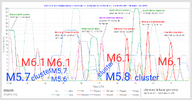
There have been more than five hundred recorded earthquakes over the last two weeks, over a dozen above magnitude 5, and the largest so far (M5.6) was just a few hours ago. Although these earthquakes are not large enough to cause significant damage, rumors have been spreading about the possibility of larger events, including about a fictional “Law of Tokara,” which states that a swarm of earthquakes in the Tokara Islands foreshadows a larger earthquake elsewhere. To be clear: there is no such law; it barely even rises to the level of pseudoscience.

But something certainly is going on below these islands!

The energy of the M6.6 earthquake could result in a worst-case scenario with another earthquake of the same magnitude in the south-central region of Chile, although events in the Sandwich Islands or the Indian Ocean cannot be ruled out.

M 5.5 - 81 km W of Cartagena, Chile
2025-07-02 01:39:39 (UTC)
33.572°S 72.486°W. 10.0 km depth
USGS
chrome_screenshot_2 jul. 2025 11_28_52 a. m. CST.png

M 5.2 - South Sandwich Islands region
2025-07-02 16:58:04 (UTC)
59.370°S 25.513°W. 35.0 km depth
USGS

Situation so far
2025-06-21-overview.png

 
Campi Flegrei, Napoli - Italy
2 July 2025


Earthquake measuring 4.6 accompanied by accelerated ground uplift – exact value not yet determined

The earthquake measuring 4.6 on the Richter scale that shook the western part of the Campi Flegrei caldera volcano on June 30 was accompanied by moderate acceleration of ground uplift. This is according to a statement from the INGV. The exact value of the accelerated ground uplift has not yet been reported. This requires correction data from satellite orbits, which is collected over several days. The exact estimate of the uplift rate will probably not be published for another 10 to 14 days. Until then, the value of 15 mm per month, which we have known since spring, will continue to apply.

The earthquake on June 30 was one of two Md 4.6 quakes that have occurred this year and are considered the strongest ever measured in the caldera.

While the earthquake on March 13 caused damage in Pozzuoli and Bacoli, the earthquake of equal strength on June 30 was mild, with no significant damage reported.

However, there were rockfalls on the small island of Pennata, which lies off the coast of Bacoli. The fact that no damage occurred is likely due to the fact that the epicenter was offshore in the Gulf of Pozzuoli, further from the coast than initially reported. The distance from the epicenter to the coast was more than 1 kilometer. In addition, the earthquake's focus was at a depth of 3.9 kilometers. The tremor manifested itself at a known fault zone that runs north-south and crosses the Gulf of Pozzuoli. It ends under Monte Nuovo, the youngest cinder cone of the caldera volcano. It can therefore be assumed that magma has already risen along this weak zone.

The depth of the epicenter also suggests that the quake was triggered by stresses caused by rising fluid accumulating beneath the hydrothermal system and beneath the caldera's cover layer.

The INGV weekly report published yesterday for the observation period from June 23 to 29 shows that there were no significant changes in geophysical and geochemical parameters prior to the earthquake. Thirty-eight weak tremors were detected during the week. The ground uplift remained at 15 mm per month and the fumarole temperature of Pisciarelli averaged 94 degrees.

There were no indications of the Md 4.6 earthquake. After the earthquake in March, it was postulated that there would be indications of stronger earthquakes accompanied by an acceleration of ground uplift, which would make it possible to predict such earthquakes. These indications were expected to consist of increased heat flow and gas emissions in the Solfatara. It is very likely that such indications only occur when a stronger earthquake is imminent in the vicinity of the Solfatara.
 
Japan govt. endorses basic plan on measures for Nankai Trough megaquake
Japan's government has officially endorsed the basic plan on measures for an anticipated massive earthquake in the Nankai Trough off the country's Pacific coast.

The endorsement was made at Tuesday's meeting of the Central Disaster Management Council held at the prime minister's official residence.

A new damage estimate released in March of this year said the Nankai Trough megaquake could in the worst-case scenario kill 298,000 people and destroy 2.35 million buildings.

The new basic plan calls for a roughly 80-percent cut in the death toll and a roughly 50-percent cut in structural damage to be attained over the next decade.

The government decided to keep the goals largely unchanged, saying it must set targets high on matters concerning people's lives.

To achieve the disaster mitigation goals, the government will make all homes in areas prone to strong tremors or high tsunami waves sufficiently quake-resistant over the next decade. It will also prepare better evacuation shelters.

The basic plan stipulates some 200 numerical targets for government measures.

The government will confirm the state of progress on such measures every year and back up regional efforts.

Japanese authorities are concerned about tourists because they are unfamiliar with the streets and safe places in the event of a tsunami. They are also trying to prevent crowds from causing further accidents as they try to flee the tsunami.​


WORLDWIDE EARTHQUAKE REPORT JULY 03_2025

Today, the seismic swarm in the Tokara Islands continues. According to Japan’s Yomiuri news outlet, the area has experienced 877 tremors since June 21, with magnitudes starting from 1.1.​

M 4.8 - 94 km N of Tatsugō, Japan
2025-07-03 05:31:06 (UTC) USGS
M 5.0 - 101 km N of Tatsugō, Japan
2025-07-03 06:11:48 (UTC)USGS
M 5.1 - 96 km N of Tatsugō, Japan
2025-07-03 06:18:11 (UTC) USGS
M 5.5 - 108 km N of Tatsugō, Japan
2025-07-03 07:13:00 (UTC) USGS
chrome_screenshot_2 jul. 2025 11_49_13 a. m. CST.png

The Japanese government has acknowledged the need for more extensive preparations to cope with the potential threat of a megaquake in the Nankai Trough. Experts estimate there is an 82% likelihood of a major earthquake occurring within the next 30 years, which could result in up to 300,000 fatalities.
JAPAN: Earthquake swarm near Tokara Islands in Kagoshima Prefecture:

On July 3 at 4:13 PM, the strongest quake so far, a magnitude 5.5 with a seismic intensity of 6 low, struck off the coast, affecting Akusekijima Island. Since June 21, over 1,050 tremors have been recorded in the region.

Professor Takuya Nishimura of Kyoto University suggests that the seismic activity off the Tokara Islands may be caused by external forces, such as magma movement, putting pressure on underground faults. Earthquake clusters in both eastern and western areas point to the possibility of multiple active faults.

Since the activity may be driven by volcanic material, it is unpredictable and likely to continue until those forces subside. With daily life already affected, residents are urged to stay alert, prepare for further quakes, and consider relocating to a safer area if needed.

A strong magnitude 5.4 earthquake hit 243 km (151 mi) away from Potosi, Departamento de Potosi, Bolivia. The intraplate earthquake occurred at a depth of nearly 183 km (114 miles).​

M 5.4 - 99 km SSW of Uyuni, Bolivia
2025-07-03 05:41:42 (UTC)
21.266°S 67.241°W. 182.6 km depth
USGS
chrome_screenshot_3 jul. 2025 7_19_25 a. m. CST.png

Other earthquakes ≥M5.0

M 5.2 - 140 km S of ‘Ohonua, Tonga
2025-07-03 08:40:09 (UTC) USGS
M 5.4 - Pacific-Antarctic Ridge
2025-07-03 10:39:24 (UTC) USGS
 
Back
Top Bottom