7.0 Quake Strikes Anchorage: Here Is Everything You Need To Know
As has been widely reported, a magnitude 7.0 earthquake struck fairly deep below Anchorage on Friday morning, at 08:29 local time. Images of corrupted roadways and videos of violently shaking buildings have been ricocheting across social media channels. Scientists are currently scrambling to explain precisely what caused the quake, while also keeping their eye on misinformation spreading on the Web.
This article will attempt to sum up everything that is known about the event so far, based solely on expert seismological testimony as well as everything the United States Geological Survey (USGS) is saying at the time of writing. It’ll also explain what may happen next, why, while debunking any rumours that may emerge from the Internet's dark ooze as the hours go by.
What Happened?
According
to the USGS, this powerful quake – initially coming in as a magnitude 6.6, but quickly upgraded to a 7.0 – struck just 13 kilometres (about 8 miles) north of Anchorage at a depth of 40.9 kilometres (roughly 25 miles).
A tsunami warning for the Cook Inlet and Southern Kenai Peninsula was initially issued, and local authorities were reportedly telling people to prepare to seek higher ground. However, the warning was
quickly rescinded after it became clear no tsunami threat existed. One was originally issued out of an abundance of caution, and because the chance a tsunami was created couldn’t be 100 percent ruled out.
Preliminary analyses suggest the most intense shaking took place just north of Anchorage, registering as an VIII (out of X) on the modified Mercalli scale, which describes surface shaking. A VIII rating means that the perceived shaking could be described as “severe” and the potential damage would range from moderate to heavy. Anchorage itself got a mixture of intensities, but the highest came in at a VII, which delineates “very strong” shaking and moderate potential damage.
What’s The Damage?
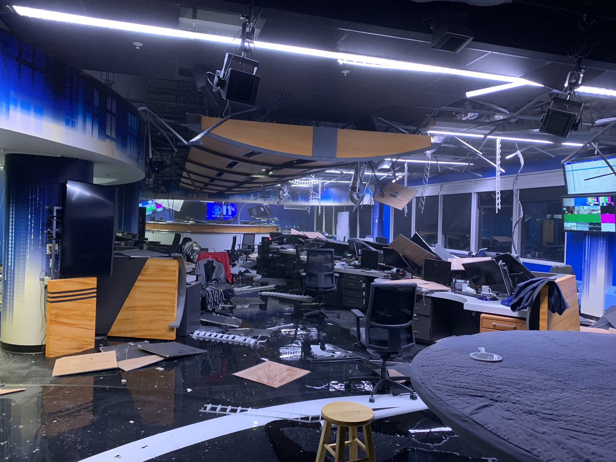
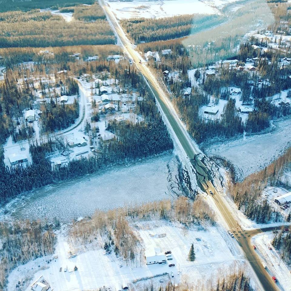
Judging by the
images and testimonies being
shared on social media, infrastructural damage is widespread. It’s not clear how severe or persistent the damage is and will be, but fragmenting roads and school buildings being carved up to an extent suggests that the city took a fairly heavy beating from the tectonic rumblings below. Alaska’s Governor, Bill Walker, has
issued a declaration of disaster.
The USGS suspects that, based on the seismic data it's received, there’s a 64 percent chance that economic losses range from
$10 million to $1 billion. Remember, though, that these are estimates, so we’ll have to wait to find out what the final total actually amounts to, which won’t be known for some time.
Conversely, the USGS currently estimates that there’s a 69 percent chance that one fatality had occurred. This is good news: putting it another way, the agency says "there is a low likelihood of casualties." At present, there have been no reports of any deaths.
This highlights the fact that magnitude, although important, isn’t the only thing that matters when it comes to an earthquake’s destructive potential. I’ve already written a detailed post
here on why this is the case, but let me sum it up again here to make things clear.
In crude terms, magnitude just denotes how much energy the earthquake has released from its source, and that's it. Plenty of other factors come into play: the geographic location of the quake, the shaking intensity of the event, the depth of the quake, the architectural designs of the affected buildings, the local population’s education and awareness of seismological dangers, the region’s sediment layers, the availability of resources for the recovery and rescue efforts, and the ability of the quake to trigger secondary geological dangers – like landslides or tsunamis – all matter.
In this case, the earthquake was pretty deep, which somewhat reduced its ability to violently shake the buildings. This depth may also explain why the shaking was fairly widespread throughout the region, although that's little more than an educated guess at this point. Anchorage is also no stranger to earthquakes (more on that in a moment) and, as reported by
National Geographic, the buildings there are generally designed to handle fairly intense shaking. This is why the damage, although bad, isn't as catastrophic as you might have expected for a magnitude 7.0 quake.
At the same time, it appears that
at least a few people acted appropriately during the shaking, based on some of the footage bouncing around Twitter. Again, I’ve written a detailed piece on what you should do in the event of a quake
here, but the basics are that you should immediately drop to the floor, cover yourself under a sturdy desk or table, and hold on until a least a minute after the shaking has stopped, and that appears to be what several in Anchorage did.
There’s no way to tell how many people took this course of action when the quake occurred, but it’s somewhat comforting to see the official advice being at least partly adhered to on social media channels. Remember, for the most part, it’s the
flying debris that kills people in earthquakes, not collapsing buildings, although this ratio varies somewhat depending on where in the world you are.
What Caused This Earthquake?
As I mentioned earlier, Anchorage is no stranger to earthquakes. The USGS’s
excellent summary of the tectonics of the region is well worth your time, but let me break it down for you with some extra context.
This quake took place at a point where the Pacific plate is moving towards and descending (subducting) under the North American plate at the Alaska-Aleutians Trench, a fair way south of the epicentre of this particular event. The grinding of these plates means that seismic events are commonplace throughout the region; in the last century, fourteen magnitude 6.0 or higher quakes have occurred, with at least two damaging quakes being of a similar depth to the November 30th Anchorage event.
This is a colossal and intricate tectonic setting, where more than one type of earthquake can occur. Boiling it down a little, you could say that there are two types of faulting that can cause quakes here: thrust, and normal faulting.
Thrust faulting tends to happen at shallower depths, where the Pacific Plate is early on in its adventures diving down into the mantle, and the plate is overall in a state of compression. This type of faulting, where one chunk of rock moves upwards over another, certainly causes shakes, including t
he most powerful in recorded US history: the magnitude 9.2 event of March 1964, whose rumbles in the Prince William Sound area generated a considerable tsunami.
In this case, however, it’s not the antagonist. The detected movement related to this quake, as well as its depth and location, gave geoscientists – including Stephen Hicks, a seismologist at the University of Southampton – a suspicion that
the faulting was normal. This tends to occur further along the plate, but still at relatively shallow depths, where the plate is bending.
Think of it like an eraser: when you bend one, the top half is stretching and extending. On the younger, shallower part of a descending tectonic slab, this creates normal faults. This involves a chunk of rock following gravity’s lead and falling downwards relative to another.
That’s what happened beneath Anchorage. The USGS’s data indicates that this normal faulting took place away from the boundary between the Pacific and North American plates. Instead, the fault slipped somewhere within the Pacific Plate further down the line, making this a within-slab or “intraslab” earthquake.
It’s worth noting that intraslab earthquakes are happening constantly at low or modest magnitudes, but they often involve thrust faulting at shallow depths. This one was a (potentially) rarer normal fault intraslab quake, which tend to be extremely energetic. Several in various locations throughout the world, from Iran to Mexico, are suspected of being so powerful that the quake actually severed their respective tectonic plates in two.
As I explain here, those events were deeply curious for several reasons, but that's a different story for another time.
What Will Happen Next?
In some ways, this is hard to say. The topography, sedimentology and geography here is complicated, but the USGS’ current analyses
suggest several things, so let's go through them individually.
The first is that any landslides triggered by this quake “are expected to be limited in number and/or spatial extent.” In addition, few people live in areas that could be affected by landslides, although damage and deaths in these areas “are still possible.”
On the other hand,
liquefaction – when unconsolidated soils, aided by water, move like a fluid in the event of earthquakes – is estimated to be “significant in severity and/or spatial extent.” Fortunately, there are also a limited number of people living in areas at risk from liquefaction.
Again, these are estimates. They're not written in stone, so authorities on the ground are carefully watching as the situation unfolds.
At the time of writing, aftershocks are occurring at a range of magnitudes. There have been 67 at a magnitude 3.0 or above so far, and more are expected. Let’s quickly go through some definitions before I explain why.
The magnitude 7.0 event was probably the mainshock, the most powerful quake in a sequence. Aftershocks are defined as smaller earthquakes taking place post-mainshock. The USGS’s models estimate that there is a
3 percent chance that one or more aftershocks will be larger than the magnitude 7.0 mainshock in the coming week, which means it is extremely probable the 7.0 event will remain the mainshock.
Aftershocks shouldn’t be underestimated though: they can take people by surprise and still cause infrastructural damage.
With that in mind, the USGS reckons that over the next week there will be anywhere between 84 and 610 aftershocks coming in at a magnitude 3.0 or above, which are strong enough to be felt if near the epicentre. There is also an 88 percent chance that there will be an earthquake of a magnitude 5.0 or higher during the same time period. This is entirely expected: the mainshock certainly involved the greatest rupture, but the normal fault, and perhaps others nearby, will keep slipping and releasing pent up stress over time.
The USGS carefully points out that “no-one can predict the exact time or place of any earthquake, including aftershocks.” Saying that, their models are pretty good at giving decent aftershock forecasts. Without a doubt, Anchorage will continue to shake for some time to come until the fault stops slipping at some undetermined point in the future.
What Does This Earthquake Not Signify?
As always happens after a major quake strikes near a populated area, some amount of bullshit will be spread around the Web about what it means, and what the future holds. So, let’s pre-empt a few of these rumours and nip them in the bud.
No, this isn’t a sign of the Big One, either up in the Pacific Northwest or down on California’s San Andreas Fault. Yes, on a very small scale – geologically speaking – earthquakes on one fault can trigger other faults nearby to slip and produce more earthquakes. Lucy Jones, seismologist extraordinaire at Caltech,
just said as much on Twitter, but here’s the important bit she hastens to add: this only applies to faults at a distance of around 3-4 times that of the primary fault itself.
In this case, the quake could trigger other, smaller quakes in faults within a 160-kilometre (100-mile) radius. That’s it. You aren’t going to initiate any catastrophes on those more famous faults or tectonic plate boundaries.
Yes, this earthquake also took place on the
so-called Ring of Fire, but Anchorage's quake isn’t a harbinger of some sort of massive “shift” or apocalyptic, Pacific Ocean-wide disaster.
The Ring of Fire refers to the horseshoe-shaped network of major tectonic boundaries around the Pacific Ocean. This is a vast and complex network, and as all the tectonic plates involved are continuously shifting around and causing each other trouble, earthquakes and volcanism will continuously take place along it. In fact, the Ring of Fire features 75 percent of the world’s volcanoes, and 90 percent of the world’s earthquakes. This 7.0 event in Alaska, then, is par for the course.
(Speaking of volcanoes, Alaska is home to plenty of active, fuming fiery mountains, sure – but this quake was
purely tectonic in nature. It didn’t involve volcanic processes at all, unlike that
bonkers seismic wave that emanated from the waters near Madagascar earlier on this month.)
At the same time, the distances involved with the Ring of Fire are huge, and the plate boundaries aren’t some sort of fragile house of cards. One major quake in Alaska will have zero effect on a fault across the ocean or even one elsewhere on the same continent. If another major quake occurs on the Ring of Fire in the next few days, some tabloids newspapers will attempt to sell you that there is, in fact, a connection.
You know what it’s really called? A coincidence.
I haven’t spotted these frequently reheated pieces of misinformation doing the rounds yet, but I wouldn’t be surprised if they cropped up. Sadly, another common villain has managed to make an unwelcome appearance already: some nefarious social media accounts are predicting that a larger quake in the region is imminent.
Earlier on, I mentioned that the USGS estimated that there’s a roughly 3 percent chance of an earthquake of a magnitude 7.0 taking place in the area within the next seven days. That is a possibility, but a very low one, and certainly isn't the same as anyone making confident predictions about such a major quake.
You don’t have to take my word for it. Mike West, Alaska’s state seismologist, took to Twitter a few hours ago to
stress that the rumours about a larger quake, featuring a precise timeframe and an absolutely certainty of occurrence, are “entirely unfounded.”
Noting that aftershocks will continue for some time, West added that “anytime an earthquake of this size occurs, there is a low but non-zero chance that another earthquake of similar or larger size could occur. This is true this time as well. However, detailed rumours about any particular earthquake are simply not true.”
The University of Alaska in Fairbanks project to study Earth's ionosphere, the
High-frequency Active Auroral Research (or HAARP) scientific endeavour, often draws the attention of conspiracy theorists. As
spotted by Earther’s Maddie Stone, it seems that they’ve also acted pre-emptively to quash such nonsense in this situation. HAARP’s Twitter account
declared that not only were they not operating at the time of the quake, but HAARP certainly “did not cause the earthquake.”
If you disagree with this in any way, you can just get into the bloody sea.
Author
Robin George Andrews is a doctor of experimental volcanology-turned-science journalist. He tends to write about the most extravagant of scientific tales, from eruptions and hurricanes to climate change and diamond-rich meteorites from destroyed alien worlds - but he's always
Planetary K Index Explained
Geomagnetic Activity and Human Health - Planetary K Index Explained - Cosmic Ray "Zero Day" Is Here