Earthquakes around the world

The Californian crack must have grown today, there was a 4.4, a 4.3 and a 4 on zero depth. Tension is still blocked from dispersing and mounting through new energy coming from Alaska. Will there be a 7.5 tonight?
 
  • Like
Reactions: Ca.

9444 earthquakes Following the 7.1 quake.. Is something bigger coming?
TheEarthMaster Published on Jul 11, 2019

I think there toning down the information. Like, down playing or suppressing perhaps under the clause of National Security.


Oh, an interesting coincidence, right?

The above chart is dated 8:42 AM - 7 Jul 2019

6-8 minute Read Last updated July 6th, 2019 Snip:
The Searles Valley Sequence started on July 4th, 2019 and so far has included one strong (M6.4, 2019/07/04) and one major (M7.1 2019/07/05) earthquake. The closes large population center is the city of Ridgecrest with a population of 28k people. Maximum shaking levels are estimated to be MMI IX (Violent) in the epicentral region and very strong shaking (MMI VII) occurred over a 40 km wide region near the epicenter that includes the city of Ridgecrest. Shaking was widely felt throughout California, including light to moderate ground shaking in Los Angeles, weak shaking in the San Francisco Bay Area, and felt shaking extending at least as far east as Phoenix and as far north as Sacramento.

Largest Events
  • 04 Jul 2019 10:33:48 PDT, (35.705, -117.508), depth 8.7km, 12km SW of Searles Valley, California
  • 05 Jul 2019 20:19:52 PDT, (35.766, -117.605), depth 10km, 17km NNE of Ridgecrest, California
Aftershocks

Aftershocks are occurring over a 50 km wide area, with a cluster of activity approximately 25 km NW from the mainshock about 10 km to the SE of the Coso Geothermal Field.
  • As of 05 Jul 2019, 04:00PM PDT, there have been nearly 3,000 aftershocks recorded in the full sequence. This significantly underestimates the total number of aftershocks as the processing system is saturated with data and smaller events in particular are not yet identified.
  • Number ≥ M7: 1
  • Number ≥ M6: 1
  • Number ≥ M5: 9
  • Number ≥ M4: 59
  • Number ≥ M3: 400
  • Aftershocks are expected to continue for months to years, but the magnitude and number will decrease through time. The largest expected is approximately 1 magnitude unit smaller than the mainshock.
  • There is a small chance (about 5%) that a larger quake could occur, with the likelihood decreasing over time.
Possible Foreshocks
  • There were 9 events during the 3 days prior to the earthquake (within a 10 km radius).
  • The largest was M4.0 (2019/07/04, about 30 minutes prior to the M6.4).
Map showing relocated current events in the Ridgecrest earthquake sequence. Events are shown size-scaled by magnitude. Figure from E. Hauksson.
6af410a21f78bb37dbf6171e97874624.png

Another example:

Our paper on the controversial 2018-19 Newdigate, UK earthquake swarm has now been accepted for publication in Seismological Research Letters (written with the fab @TheFracDoctor @BGSseismology @ZoeMildon @TMGernon). Accepted pre-print @EarthArXiv https://eartharxiv.org/b2ypu
 
Two days after flash flooding in Washington:
Dangerous flash flooding hits Washington DC during morning commute

A magnitude 4.6 earthquake hits Seattle:

Magnitude 4.6 Earthquake Hits Just Outside Seattle

SEATTLE — The U.S. Geological Survey reports that a 4.6 magnitude earthquake has rattled the Three Lakes area of Washington state, less than 50 miles northeast of Seattle.

The earthquake initially registered as a 4.7 magnitude and was then downgraded to 4.4 before eventually going back up to a 4.6. The quake hit at about 2:52 a.m.

The earthquake was relatively shallow, but according to the USGS map, it was felt all the way to the Canadian border.

The epicenter of the quake was near Monroe in Snohomish County.

 
Quake of magnitude 6.1 strikes north of Japan's Okinawa: USGS
July 12, 2019 - An earthquake of magnitude 6.1 struck north of Japan's islands of Okinawa on Saturday, the United States Geological Survey said.

There were no immediate reports of damage or casualties from the quake, which hit at a depth of 257 km (160 miles), about 346 km (215 miles) north of Naha, the capital of the prefecture.
 
M 6.6 - 202km W of Broome, Australia
V
DYFI?
VI
ShakeMap
GREEN
PAGER

Time2019-07-14 05:39:24 (UTC)
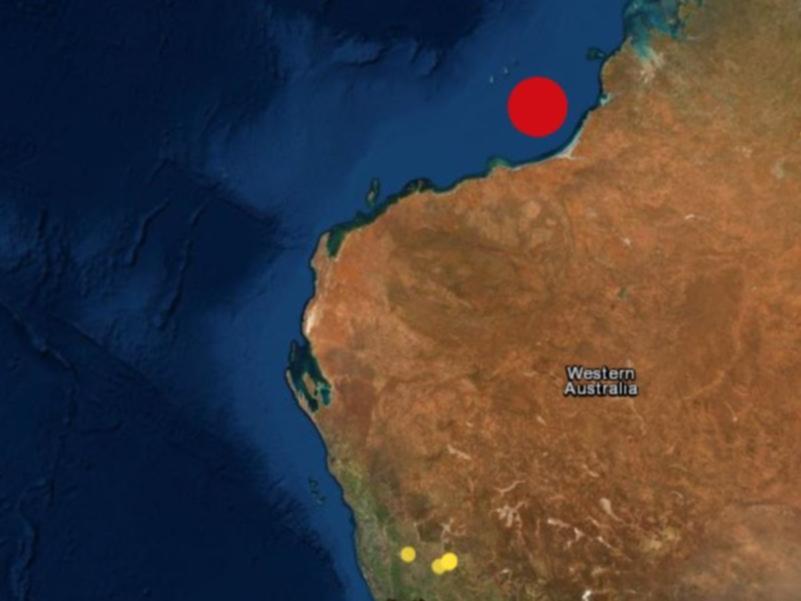
Location18.202°S 120.337°E
Depth10.0 km

---
It is the strongest quake ever recorded in Western Australia:
Earthquake shakes WA from Perth to Broome
Staff reportersThe West Australian
Sunday, 14 July 2019 7:52AM

Where the reports of the quake had been registered with Geoscience Australia as of 2pm.
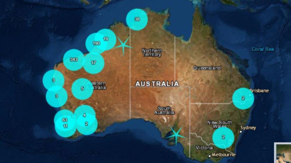
Where the reports of the quake had been registered with Geoscience Australia as of 2pm.Picture: Geoscience Australia

An earthquake has hit WA with tremors felt from Broome all the way down to Esperance in what is believed to be the strongest quake to ever hit the state.
Originally listed as a 6.6 magnitude quake, the strength has since been upgraded to 6.6 after it struck off the Kimberley coast at 1.39pm on Sunday.
According to Geoscience Australia the quake hit 300km due west of Broome and has seen reports of tremors being felt as far south as Esperance and as far north as Darwin.


There are no reports of major damage and the Joint Australian Tsunami Warning Centre said there was no risk of a tsunami.
But senior seismologist at the Government’s GeoScience Australia, Phil Cummins, said that aftershocks are to be expected.
He said it was difficult to tell when or how many might occur but said they would decrease in size and likely happen further apart.
Wine bottles fell and smashed at the Roebuck Bay Hotel in Broome.
Wine bottles fell and smashed at the Roebuck Bay Hotel in Broome.Picture: Picture: Carly Laden

As of 2pm as many as 800 people had logged in to the government website to register having felt the quake - with more than 500 being registered on the north west coast.
There were more than 200 reports from Broome and another 251 in Port Hedland.
One person posted on Facebook saying that the intensive care ward at Sir Charles Gairdner Hospital shook for a full minute - with more than 70 reports registered in Perth.
1563088186947_GL22AFSHO.1-1.jpg
Picture: Geoscience Australia
Tremors were also recorded in Darwin with nearly 40 people saying they felt it in the Northern Territory, while incredibly there was also 2 reports from both Melbourne and Brisbane.
Sunday’s quake eclipses the strongest ever recorded in WA, with Meckering’s devestating 1968 quake registering 6.5 on the Richter scale.
Even though the earthquake was felt as far away as Port Hedland, the South Hedland Police and DFES have not had any reports of damages as of 3pm.
An aftershock hit the region at 2:35pm, with a reported magnitude of 4.1.
 
Was the earthquake in Broome a foreshock to the one now in Indonesia less than 4 hours later:
M 7.3 - 102km NNE of Laiwui, Indonesia
VII
ShakeMap
GREEN
PAGER
Tsunami Warning Center
Time2019-07-14 09:10:50 (UTC)
Location0.529°S 128.093°E
Depth10.0 km

Magnitude 7.3 Earthquake Strikes Near Molucca Island, Indonesia - USGS
© AFP 2019 / Richter magnitude scale
ASIA & PACIFIC
12:35 14.07.2019(updated 12:59 14.07.2019)Get short URL
0 12
Last week, the Indonesian authorities issued a tsunami warning following a 7.1-magnitude earthquake in the Molucca Sea.
A 7.3 magnitude earthquake occurred on Saturday near the Indonesian island of Molucca, US Geological Survey has reported.
The quake occurred at a depth of 10 km (6 miles) at an area 168 km south-southeast of Ternate. There's currently no information on casualties or damages.

Indonesia is located in a seismically active zone girdling the northern Pacific Ocean known as the Ring of Fire and regularly suffers from powerful earthquakes.
Last September, a devastating 7.5-magnitude earthquake struck the Indonesian island of Sulawesi, followed by tsunami waves more than 20 feet high that smashed the island. Nearly 70,000 homes were destroyed or damaged, 80,000 people displaced and about 2,000 people killed, according to the Indonesian government.
 
July 13, 2019 - Scores injured as 5.8-magnitude quake rocks southern Philippines
1664626-1602741200.jpg

The Philippines is part of the Pacific ‘Ring of Fire’ — an arc of intense seismic activity that stretches Japan through Southeast Asia and across the Pacific basin. (AFP file photo)

The 5.8-magnitude quake struck the northeast coast of Mindanao island early Saturday morning

Fifty-one people were injured and several homes, churches and other buildings damaged on Saturday when an earthquake sent terrified residents of the southern Philippines fleeing their homes before dawn, police said.

The 5.8-magnitude quake struck the northeast coast of Mindanao island at 4:42 A.M. (2042 GMT Friday) at a depth of 11.8 kilometers, with the Philippine seismology office also recording seven less intense aftershocks.

The country’s most recent deadly quake occurred in April when at least 11 people were killed in a 6.3-magnitude temblor that hit a region north of the capital Manila, causing a supermarket to collapse.
 
Here in Mexico City, we just had this morning, around 8AM, tree earth
movements, included a 2.5 earthquake. The epicenter was just beneath one of our oldest municipal cementeries. It felt like if something exploded down there. It was weird.
There had been 7 mini (2.0-2.5 magnitude) earhquakes with epicentre in Mexico City from June 12th to June 14th, according to (Mexican) National Seismological Service ...
30793
 

The Big one on the San Andreas Fault... Could it be under more stress?
TheEarthMaster Published on Jul 15, 2019 / 26:49


THE SOLAR WIND IS HERE: Earth is entering a stream of solar wind flowing from a hole in the sun's atmosphere. So far the gentle action of the stream has not caused significant geomagnetic activity. Nevertheless, minor geomagnetic storming is possible later today as the solar wind velocity increases to forecast values of 500+ km/s. Aurora alerts: SMS Text.


Back
Top Bottom