Fires around the world

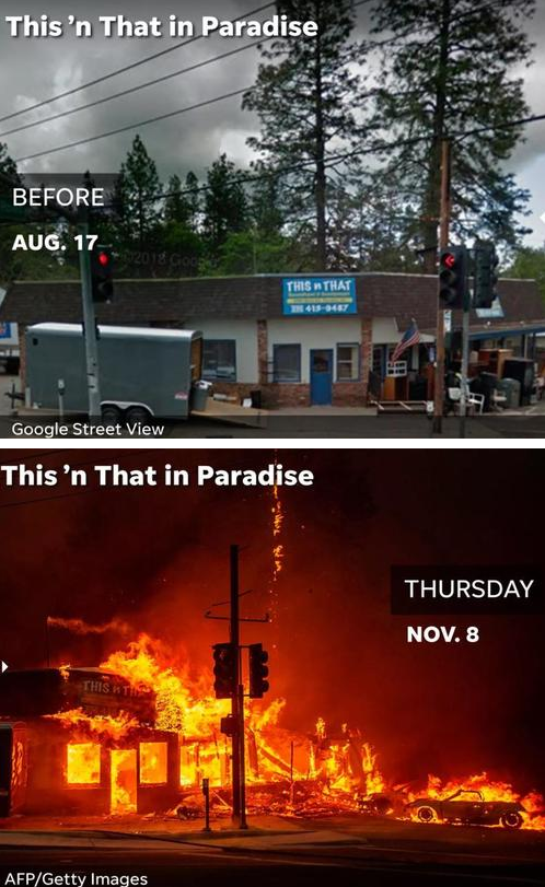
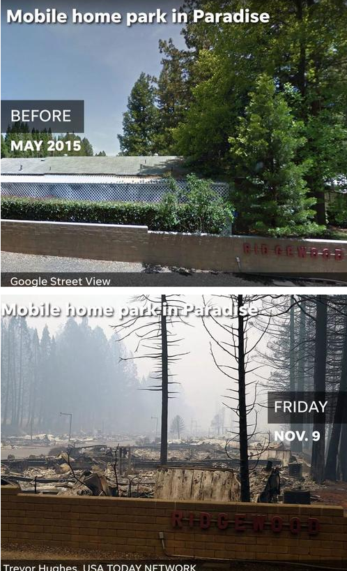
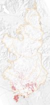
This is the third time in 13 months we Northern Californians have been told that the ongoing fire is the most destructive fire on record. No, wait, the Ranch fire just a few months ago was the largest in CA history. Any ideas why multiple fires start at often exactly the same time in different areas?

That's a very interesting question. It all seems to have some other explanation other than what we are being told.

Meanwhile:
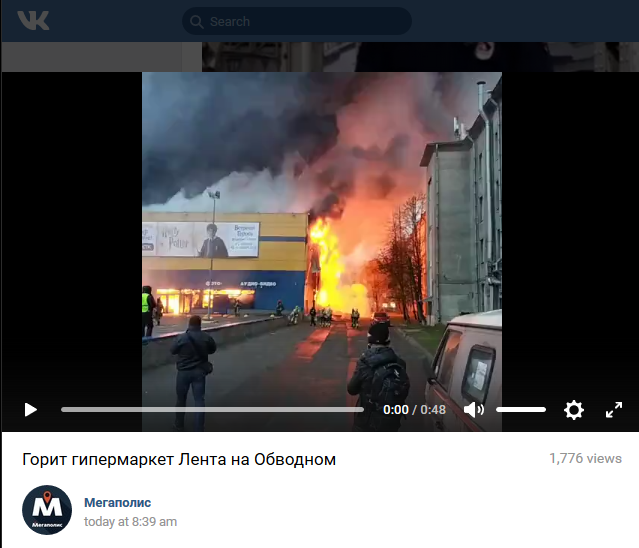
Around 800 shoppers were forced to flee a mall in the Russian city of St. Petersburg when a massive fire broke out inside. Pictures have emerged on social media showing plumes of smoke billowing from the burning building.

One of the buildings of the popular supermarket chain, ‘Lenta,’ was engulfed by flames at around 8am local time on Saturday. The inferno raged across an area almost the size of a football field, around 5,000 square meters.

The 24-hour shop was open at the time of the incident. Tass reported that one person was injured, but this has yet to be confirmed by the emergency services.


Emergency services told the media that the fire may have started on the roof of the building, which subsequently collapsed.

Locals took to social media to share dramatic pictures and footage of the blaze. Plumes of thick, black smoke could be seen from various parts of the city.

More than 50 firefighters were sent to battle the fire and managed to bring it under control in around two hours. There is no threat to any other buildings in the area.

 
Any ideas why multiple fires start at often exactly the same time in different areas?
That's a very interesting question. It all seems to have some other explanation other than what we are being told.
A BLAST FROM THE PAST (WARTIME SPACE WEATHER IN VIETNAM)
[...]
Turns out, it's legendary in the Navy, too. According to a research paper just accepted for publication in the journal Space Weather, declassified Naval archives reveal an extraordinary explosion in the sea lanes near Vietnam: "On 4 August (1972) TF-77 aircraft reported some two dozen explosions in a minefield near Hon La over a 30-second time span...Ultimately the Navy concluded that the explosions had been caused by the magnetic perturbations of solar storms, the most intense in more than two decades."
Maybe electricity on/in the surface of the earth induced by solar activity could spark something?
 
Minas Tirith said: said:
Any ideas why multiple fires start at often exactly the same time in different areas?
c.a. said: said:
That's a very interesting question. It all seems to have some other explanation other than what we are being told.

A BLAST FROM THE PAST (WARTIME SPACE WEATHER IN VIETNAM)Maybe electricity on/in the surface of the earth induced by solar activity could spark something?

Multifactorial I think, but I remembered that, there was a massive leak of gas at south of California, and there were many earthquakes in past days, so, for me is somehow simple. I had seen several images/videos and, is a literal infierno, a nightmare ... I hope those people find solace soon Massive natural gas leak in Southern California could take months to plug -- Sott.net
 
Some 149,000 Californians are effectively homeless after fleeing from the Camp, Woolsey and Hill fires, which have afflicted Butte County, as well as Ventura and LA counties and destroyed more than 6,700 homes and buildings, with thousands more expected to burn. And as the death toll hits 31, putting this round of wildfires on track to become the deadliest in the state's history as more than 200 people remain missing, a picture of the total damages that have been wrought by the fires is beginning to emerge. According to Bloomberg, the state, insurers and homeowners could be on the hook for a combined $19 billion in damages.

Though that is a staggering sum, at least one analyst believes it's a conservative estimate. To put it in context, Hurricane Harvey caused more than $100 billion in total economic devastation when it slammed Houston last year. Though the total sum could be on par with Hurricane Michael, which slammed the Florida panhandle and parts of the southeastern US last month.

downed%20line.jpg

"The California fires are as bad as folks think they are," said Chuck Watson, a disaster modeler at Enki Research. He pegged the possible damages of about $25 billion once the fires have been put out and the total damage can be assessed. Insurance for fire-related damages is already becoming an issue.

Some 8,000 local, state and federal firefighters have arrived to battle the flames as hot, dry "devil winds" are set to persist for much of this week. Already, the Camp Fire has destroyed more structures than any other California wildfire since data collection began. Among the losses include dozens of celebrity-owned homes in Malibu, where the Woolsey and smaller Hill fires are wreaking havoc. Up north, the entire town of Paradise, Calif. has been leveled by the flames.

The blazes have spread to cover a combined 200,000 acres. Gov. Jerry Brown has asked President Trump to issue a "major disaster declaration" that would give California access to federal aid - though there's a chance that Trump might be reluctant to release the money.

"We’re putting everything we’ve got into the fight against these fires, and this request ensures communities on the front lines get additional federal aid," Brown said in a statement.

In a harrowing series of images, USA Today showed before-and-after images of homes and businesses in Paradise.

d0af6f6a8fc3f86cfdb31965415e6c3c.png


b208a289246f72dfe04fbc80a9f00c97.png


The NWS warned over the weekend that there appears to be no end in sight for the blazes, as the forecast is largely free of seasonal rain. Extinguishing the Woolsey fire could take another five days, and it could take the rest of November to extinguish the Camp Fire, according to CalFire.

Looters

Butte County police have arrested several men suspected of looting during the Camp Fire. The men were reportedly trying to impersonate Forest Service personnel to gain access to the area.


To some news the fire in California spreads with a high speed when it comes to the scale. CNN reports that the fire burns about 80 football fields in a minute:


Others report about this number too. Which seems to be quite fast at the first glance, even incredibly fast. When you calculate that number with the smallest possible side length of a football stadium, which is 50 Yards (about 46 Meters), you come to a distance covered by the fire of 3680 Meters in one minute, which is 220 km/h! If you calculate with 100 yards for a football stadium, you get double of that amount; 7360 Meters in one minute which would be 442 km/h!

Since both numbers just seem to be almost impossibly fast, I guess that you can't calculate it like this I have something wrong in my approach of calculating the speed. I tried to find out how the speed of wildfires is actually calculated and how they defined that number of 80 football fileds. I guess they calculate with square meter burned. I'm not sure.

Also tried to find out some concrete speeds of this current fire, with no luck and also how they compare to other fires in terms of speed, no luck either.

Notice that the Tubbs Fire (last year), had a simlar signature of speed, and progression.

How California’s Most Destructive Wildfire Spread, Hour by Hour
OCT. 21, 2017 (Link for more details on Map)
SANTA ROSA, Calif. — An analysis by The New York Times of satellite images, combined with on-the-ground surveys, provides a more complete picture of the origin, spread and devastation of the fire that killed at least 22 people in and around the city.

The Tubbs fire destroyed at least 5,200 homes and structures, shown on the map below, making it the most destructive wildfire in state history, as well as one of the deadliest. The Times analysis also shows how quickly the fire spread in the crucial initial hours.

The fire was pushed downhill at unusually high speeds by winds that sometimes exceeded 50 miles per hour. Burning embers were blown ahead of the main front, leaping ahead and igniting new fires.

In about three hours, the fire reached Santa Rosa, causing a chaotic scramble among authorities and unprepared residents.

One resident said that by the time the first emergency alert came, the flames were already marching toward his house, leaving just minutes to escape. As their city became engulfed in flames, many residents frantically fled their homes. But some people were unable to escape, and in many cases, their remains have been recovered inside or near their homes.
 

Attachments

  • tubbs-Artboard_11 2017.jpg
    tubbs-Artboard_11 2017.jpg
    2.1 MB · Views: 5
Also tried to find out some concrete speeds of this current fire, with no luck and also how they compare to other fires in terms of speed, no luck either.

Don't know what specifically the speeds were, yet there are some rules of thumb related to wildfire and wind represented in what's called ISI or Initial Spread Index, however, other variables persist; fuel type and size, terrain (upslope/down slope), drought index, RH et cetera. There is even a newer index: 'The Hot-Dry-Windy Index' (pdf) that removes some of the traditional FWI (Fire Weather Index) and looks to inputs of weather alone;

Complex interactions at multiple scales between fire, fuels, topography, and weather (e.g. combined with imperfect input data and insufficient model resolution make it practically impossible to produce perfect forecasts of fire conditions. Some researchers have tried to account for these interactions by using statistical analyses. The tools developed by these researchers have usefulness in certain situations, but often fail when tried at different locations or with different data because they are inherently dependent upon the input data and events used to define the tools.

For this study, we want to isolate the effects of weather on a wildland fire, so we define a fire weather index (FWI) as an index that includes only weather inputs and thus does not include explicit or implicit information about the state of wildland fuels or topography. Using this definition, the only FWIs in the literature are the Lower Atmospheric Severity Index and a logistic-regression-based FWI recently developed for the Northeast United States.

Of these FWIs, only the HI is widely used operationally to predict when weather conditions will make a wildland fire difficult to manage.

I would have to read more of this.

Here is the ISI as defined by FWI (pdf - here by one fuel type):

Initial Spread Index (ISI)

The ISI combines the FFMC and wind speed to indicate the expected rate of fire spread (Fig. 5). Generally, a 10 mph (13 km/h)
increase in wind speed will double the ISI value.

The ISI is accepted as a good indicator of fire spread in open light fuel stands with wind speeds up to 25 mph (40 km/h)

Figure 5, .Rate of spread for the mature jack or lodgepole pine fuel type on level terrain as a function of ISI (from Alexander, Lawson, Stocks and Van Wagner 1984)


Figure 5.

1542057398675.png


(from article);
The fire was pushed downhill at unusually high speeds by winds that sometimes exceeded 50 miles per hour. Burning embers were blown ahead of the main front, leaping ahead and igniting new fires.

This spotting ahead is scary enough, and one reason is that the main fire is sucking oxygen (sides, front and above) - creating its own winds (fire-weather), which flairs the 'ahead spotting' quickly to join the main fire, sort of like murcury flowing together.
 
What about meteor showers coming through? I remember reading Laura's "Horns of Moses" talking about all of this. Not fires, but... It certainly would explain the distributions in a narrow band from north to south or vice versa ...and the strong winds before ...
 
  • Like
Reactions: Meg
Nov 12, 2018

Published on Nov 12, 2018
Brad Weldon and his friend Michiel McCrary chose not to evacuate during the Camp Fire and fought off flames and kept Brad's home and his 90-year-old mother safe

Published on Nov 12, 2018
 
I just did a search on Google for "dew weapons California" - without quotes. I was a bit surprised to find a lot of hits in the top 10 that support the claim that DEW or direct energy weapons are not such a far-flung explanation for the California Fires.

Google does a good job of suppressing viable "conspiracy theories" but seems to be propagating this one. So the powers-that-be are sending shafts of energy/light down from the heavens to burn houses in Cali? Why? Are they advertising the fact that they want to do us in? The DEW meme is rampant on FB, epidemic in fact. Seems like this meme is being 'stoked'.

I don't by it. This is cover for something else perhaps. :evil::whistle::evil:
 
Wildfires Continue To Devastate California Communities | Sierra News Online
CALIFORNIA – The deadliest fire in the state’s history continues its path of destruction through Butte County in northern California as the death toll rises to 48 in the Camp Fire.

Meanwhile, firefighters continue their battle against the Hill and Woolsey Fires on the southern end of the state.

There are currently more than 9,300 firefighters assigned to these three incidents, covering 1,179 fire engines, 121 dozers, 161 hand crews, 123 water tenders, 45 helicopters and numerous firefighting air tankers from across the state, along with numerous out-of-state resources.

These wind-driven fires have burned more than 237,151 acres and destroyed thousands of structures.

Currently, two strike teams of Type 3 engines from the Madera-Mariposa-Merced Unit are fighting fires off the unit, along with one team of Type 1 engines plus ground crews and dozers.

Extremely dry conditions and dangerous fire weather will continue to challenge crews into the weekend.

In the Northern Region, other than occasional breezy conditions, winds are forcast to be lighter through the rest of this week. However, conditions will remain very dry with above normal temperatures, so elevated fire weather conditions will persist through the week. Widespread poor air quality due to smoke will likely continue.

In the Southern Region, strong Santa Ana winds will continue today with sustained winds at 20-35 mph with gusts 45-55 mph expected. Higher gusts are possible in the mountains and other prone locations.

Relative humidity will remain low with extremely dry conditions ranging from 3-10 percent, with poor overnight recoveries. Critical fire weather conditions will persist today. After winds decrease later this afternoon, elevated fire weather will linger throughout the week.

With these current extreme fire conditions throughout the state, Cal Fire warns everyone, “Don’t wait to evacuate! You should already be PREPARED and GO! early. If you see fire approaching, don’t wait to be told to leave.”

To learn more on preparing to evacuate, click here.

Click on the links below for detailed information on each of these fires.

Current fire information:

Camp Fire, Butte County (more info…)
Paradise, Pulga, Concow and Magalia
  • 135,000 acres, 35% contained
  • Evacuations and road closures remain in effect
  • There are currently 5,615 personnel assigned to the incident including 630 engines, 99 crews, 23 helicopters, 105 dozers and 74 water tenders.
  • Estimated 6,867 structures destroyed. Most destructive and deadliest fire in California recorded history
  • Cal Fire Incident Management Team 4 (Derum) assigned
  • For a map of the Camp Fire evacuation zone, click here.
Hill Fire, Ventura County (more info…)
Santa Rosa Valley
  • 4,531 acres, 94% contained, expected containment date is Nov. 15
  • Cal Fire Incident Management Team 5 (Parkes) assigned. IMT#5 managing both Hill and Woolsey fires
  • Two structures have been damaged and two destroyed
Woolsey Fire, Ventura County (more info…)
South of Simi Valley
  • 97,620 acres, 47% contained
  • Evacuations and road closures remain in effect
  • Cal Fire Incident Management Team 5 (Parkes) assigned. IMT#5 managing both Hill and Woolsey fires
  • Click here for the evacuation map of the Woolsey Fire
  • 483 structures have been destroyed, 86 damaged, 57,000 are currently threatened
  • There are currently 3,685 personnel assigned to the incident including 544 engines, 62 crews, 22 helicopters, 16 dozers and 46 water tenders
  • There have been 3 firefighter injuries and 2 civilian fatalities

#CampFire: 911 dispatch audio from firefighters in Paradise on Nov. 8
Published on Nov 13, 2018
Audio from 911 dispatchers illustrates how firefighters and public safety officials remained calm and steadfast as they worked to rescue trapped civilians in Paradise, Calif. when the #campfire broke out on Nov. 8

#CampFire: Retired Brentwood fire captain escorted caravan to safety in Paradise
Published on Nov 13, 2018
Retired East Contra Costa Fire Captain John T. Foster and wife Patty had recently moved to Paradise after living in Brentwood for 35 years where he worked for the ECCFPD. The Camp Fire on Nov. 8, 2018, destroyed their home, which was not yet insured, in Paradise.


What is clearly shown by that Magalia video is something that it is REALLY hard to get people to accept: in forest fires, trees generally don't burn to the ground, houses and cars do! Why? Because the water content of the average tree is much higher than that of the average house or car.
 
16/11/2018 - Number of missing people in California wildfires doubles to over 630
[URL="https://www.euronews.com/2018/11/16/number-of-missing-people-in-california-wildfires-doubles-to-over-630#spotim-widget"]Number of missing people in California wildfires doubles to over 630[/URL]

[URL='https://www.euronews.com/2018/11/16/number-of-missing-people-in-california-wildfires-doubles-to-over-630#spotim-widget']The number of people declared missing in one of California’s catastrophic wildfires has more than doubled to 631, as the struggle continues to contain one of the biggest blazes the US state has ever known.


The Camp Fire, which broke out a week ago in the drought-affected Sierra Foothills 280 kilometres north of San Francisco, has left at least 63 people dead. Another three people died in a fire in Southern California.

The revised official list of people unaccounted for, issued by the Butte County Sheriff’s Office, leapt from 297 – a figure given earlier on Thursday – to 631.

Sheriff Kory Honea said nearly 300 people initially reported as missing had been found alive, and the list would keep fluctuating as people were found safe or identified among the dead. At an evening news briefing he said the remains of seven more victims had been located since Wednesday.

The sheriff has asked relatives of the missing to submit DNA samples to help identify the dead. He said some of those unaccounted for many never be found.

Paradise devastated
The high number of dead and missing is attributed to the speed with which the flames, driven by high winds and facilitated by parched scrubland and trees, raced through the town of Paradise.


Most of the town – nearly 12,000 homes and buildings – has been destroyed, and an army of firefighters, many from other states, joined the struggle to contain and suppress the flames.

Those who survived the fires but lost homes have been moving in with friends or relatives, or staying in emergency shelters. Dozens of people have pitched tents or slept in cars outside a Walmart store in Paradise.

In Southern California, where there have been several smaller fires, the Wolsey Fire has been linked to at least three deaths and hundreds of destroyed buildings in the hills around Malibu, west of Los Angeles.

The California Department of Forestry and Fire Protection (Cal Fire) said on Thursday that a greater perimeter of both the state’s major fires had been contained.

Across the state, more than 9,000 firefighters are involved in the fight to contain the fires.

Trump visit
The White House has said Donald Trump will visit California on Saturday to meet people affected by the disaster.
Last weekend the US President
blamed “gross mismanagement” of the forests for the fires, and threatened to withhold federal payments.

Trump’s comments, which came shortly after he Trump issued an emergency declaration to allow US government funds to be used to tackle three blazes, prompted an angry response from firefighters.

Some experts have called into question forest management methods. But scientists largely attribute the disastrous wildfire seasons California has experienced over the past couple of years, to prolonged drought symptomatic of climate change.

Published on Nov 15, 2018 (1:18 min.)


Number of people missing in California wildfires spikes to more than 600
Published on Nov 16, 2018 (2:11 min.)

[/URL]
 
  • Like
Reactions: Ca.
Back
Top Bottom