Chad
The Living Force
Regarding the Canada fires:

All Of South Quebec Simultaneously Erupts in Flames! (Proof it was ARSON!)
mirrored from Rumble RedPillUSAPatriots channel It was all planned to force folks into 15 minute cities... and also to cause a Canadian rural land grab. Plus it makes it hard to breathe making the vulnerable ill. Turdeau sent billions in aid to other countries and to the bullshit war in Ukraine...www.bitchute.com
This reminded me about the extreme fires Greece experienced aprox 2 years ago; when I asked fellow greek crew members they were suspecting "foul play" involved in their country.
I'm not sure whether you're referring to 2021 but indeed arson was suspected in a significant number of the fires, and not just in Greece, but across Europe - there's this artcle on SOTT : Arsonists responsible for devastating fires in Greece, Italy, Turkey - reports -- Sott.net
From the article there's this quote that highlights how this has been a problem as far back as 2017:
Back in 2017:
"It's arson according to an organized plan," Justice Minister Stavros Kontonis, who is the MP for Zakythnos, told state TV when asked to comment on the dozen fires burning on the island. "There is no doubt about it."
As for this year, i was recently told that in some regions of the UK it has been unusually dry (the North West, as one example), that the grass is already brown and 'dead', and that at least a few of the smaller fires were caused by people leaving small BBQs out; an activity that has become popular in the last decade or so with the affordability of the disposable BBQs.
Whatever the cause of ignition, it seems that conditions in some regions are ripe for fire; what's causing those conditions and whether it's abnormal, i can't say. It could be that there's less rain, or a lack of consistent rain over certain periods, perhaps even the strength of the sun is playing its part?
I came across the following article, published yesterday, about the alleged increased risk of wildfires in Ireland that i thought was kind of interesting:

Wildfire warning amid fears over tinder-like conditions nationwide
TINDER-like conditions in Ireland's forests, beaches and mountain sides prompted a major fire safety warning as a forecast of rainfall this weekend won't sufficiently dampen a parched countryside.
Wildfire warning amid fears over tinder-like conditions nationwide

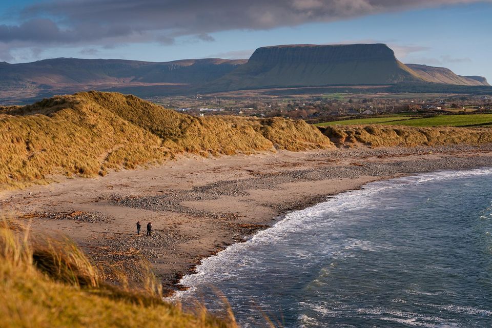
Streedagh Beach Sligo
Ralph Riegel
Yesterday at 18:04
TINDER-like conditions in Ireland's forests, beaches and mountain sides prompted a major fire safety warning as a forecast of rainfall this weekend won't sufficiently dampen a parched countryside.
The warning came as Galway fire brigade battled to control a major gorse fire in the Rahoon-Boleybeg area - and required units from both Galway city and Athenry to prevent the blaze from spreading.
Concerns over the potential spread of the blaze in the tinder-like conditions were so great that fire officials used drones to assess the direction and speed of the blaze.
The Galway fire came just 24 hours after Cork fire brigade raced to control a similar gorse blaze in Kilmurry - and a large dune fire erupted in Maharees in Kerry.
Tralee fire brigade were praised for their speed in stopping that fire from spreading within the delicate dune ecosystem.
However, a substantial area of the famous sand dunes were left badly scorched.
One theory now being investigated is that the Kerry dune fire may have been started by a carelessly discarded cigarette.
Both Coillte and the National Parks and Wildlife Service pleaded with people enjoying the outdoors to be careful of fire risks - and never to light barbecues or have open fires in public places.
Cork and Kerry have already reported almost a 200pc increase in the numbers of gorse blazes being dealt with in the space of just 12 months.
The most serious gorse fires occurred in west Cork last February.
Up to 20 separate gorse fires - used to clear land for farming purposes - merged and threatened to entirely engulf parts of the Mizen and Mt Gabriel overlooking the west Cork village of Schull.
Dry conditions and strong winds fanned the fires into an inferno which swept around one mountain and even threatened a strategic Irish Aviation Authority (IAA) air traffic control hub.
NPWS director general Niall O Donnchú appealed for people to be aware of fire risks and the potentially catastrophic consequences of such uncontrolled blazes given the current parched nature of the ground.
"We still need to enlist the public's help to protect nature at this high risk time," he said.
"We ask that members of the public not light fires or barbecues in any national parks or nature reserves, or indeed in nature generally. We are also asking that the public be vigilant and report any fire activity without delay.”
The appeal came as Uisce Éireann admitted that the rainfall forecast for the next three days may not be significant enough to sufficiently boost under-pressure reservoirs and water systems.
Over 20 reservoirs and water systems are now officially in drought status.
[bearing in mind reservoirs have been poorly maintained and usage increases yearly and so they're probably are not an accurate reflection of actual rainfall]
Some 24 of Met Éireann's 25 principle weather stations are currently observing absolute droughts lasting between 15 and 23 days - a drought being defined as a period of 15 or more consecutive days with daily rainfall of less than 0.2mm.
[it's surprised me that this is the definition of a drought - specific to the region?]
The longest absolute droughts of 2023 are ongoing at four stations in Wexford, Dublin and Carlow with 23 consecutive days of minimal rainfall since the Riviera-like conditions began in May.
All 25 of Met Éireann stations are now experiencing official dry periods of between 15 and 26 days - a spell not experienced by Ireland since 2018.
Uisce Éireann warned that water conservation was now critical over the coming weeks given the potential of a further dry spell from late June into July having a significant impact on national water resources.
A total of 21 of Ireland's 711 water treatment plants are currently battling drought conditions.
[that's not so bad?]
Uisce Éireann's asset operations manager Tom Cuddy warned householders and businesses that water conservation was now critical over the coming days and weeks.
"With no significant rainfall forecast in the short term, we can all play our part in ensuring there is enough water for everyone as we go through the summer. Even small changes can make a significant difference."
Met Éireann's Mark Bowe said the Mediterranean-like weather spell was about to end with showers and very warm, humid conditions likely over the weekend.
"Friday will start off fine and mostly dry with a light to moderate easterly breeze. A few morning showers will develop across parts of the south, drifting into the west later," he said.
"More clouds will build later in the afternoon with highest temperatures of 18C to 25C."
Friday and Saturday nights will prove very warm and humid, with some areas proving uncomfortably humid with overnight temperatures as high as 16C.
"Saturday will be generally cloudy with scattered showers moving up from the south to many parts through the morning and afternoon, reaching the north later in the evening. Some of these showers may be heavy."
"There will be hazy sunshine likely ahead of the showers. It will be warm with highest temperatures of between 20C to 25C."
"Sunday will see a mixture of cloud and scattered showers but there will be some sunny spells at times and highest temperature of 20C to 24C."
Next week is likely to open with similar conditions of clouds, patches of rain and spells of sunshine.
Temperatures will remain high with the potential to reach 25C or even 26C.


