Fires around the world

California becomes a tinderbox.

To the State of California. Please read "Earth Changes and the Human-Cosmic Connection"
Chapter-41 "The Truth Factor"
https://www.youtube.com/watch?v=73LdJMCIuvU


https://youtu.be/SprUL8gcBAE

Some Quotes of the fire's behaviors:

Detwiler Fire Incident Information:
_http://www.fire.ca.gov/current_incidents/incidentdetails/Index/1672
Last Updated: July 18, 2017 8:30 pm
County: Mariposa County, California
Acres Burned - Containment: 25,000 acres - 5% contained
Long/Lat: -120.21321/37.61757
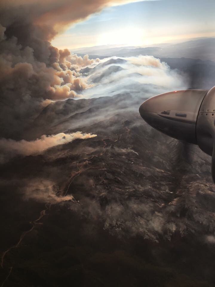
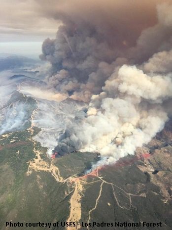
Today, firefighters experienced extreme and aggressive fire behavior with active crowning, short- range spotting and uphill runs. The communities of Hunters Valley, Bear Valley, Catheys Valley, Mormon Bar, The Town of Mariposa , Mount Bullion, Yaqui Gulch/Aqua Fria areas and Hornitos continue to be threatened.
The fire encroaches on culturally and historically sensitive areas.
Traffic along HWY 149, 49N and 49S will be impacted as a result of road closures.

The fire continues to threaten power lines to the south of the incident, which supply power to Yosemite National Park. Firefighters on the ground as well as aircraft are actively working to contain and suppress the fire.

We ask for the public to heed all evacuation orders and warnings.

Park Fire Incident Information: Fresno County Ca.
Last Updated: July 18, 2017 6:00 pm
Date/Time Started: July 17, 2017 1:15 pm
CAL FIRE / Fresno County Fire
Long/Lat:-120.55579/35.95911
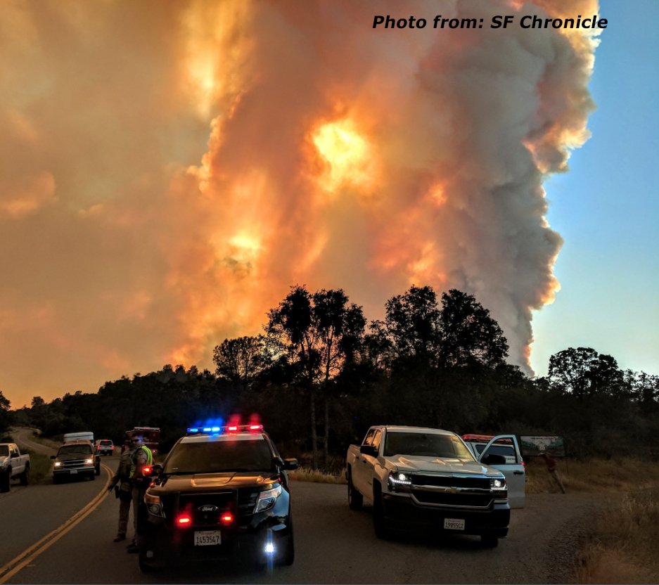
Conditions: Fire is actively burning in tall grass, brush and timber. Firefighters are working aggressively in steep and rugged areas with inaccessible terrain which is hindering firefighting efforts. Structures in the area and high tension power lines are threatened.

CAL FIRE‏Verified account @CAL_FIRE 2 hours ago
#WhittierFire [update] in the Lake Cachuma area, S of Hwy 154 (Santa Barbara Co) is 18,331 acres and 66% contained. _https://inciweb.nwcg.gov/incident/5339/
DFEmaF0UwAAqq_N.jpg


CAL FIRE‏Verified account @CAL_FIRE 11 hours ago
#DetwilerFire [update] east of Lake McClure (Mariposa County) now 19,600 acres and 5% contained. New evacs in effect _http://www.fire.ca.gov/current_incidents/incidentdetails/Index/1672 …
DFCn_JMVYAAjzcA.jpg


Detwiler Fire Time Lapse 7:19 AM - 18 Jul 2017 Video/:29
CAL FIRE‏Verified account @CAL_FIRE
_https://twitter.com/CAL_FIRE/status/887315890974240769
#DetwilerFire [update] 2 miles east of Lake McClure (Mariposa County) is now 15,500 acres and 5% contained. _http://www.fire.ca.gov/current_incidents/incidentdetails/Index/1672 …

CAL FIRE‏Verified account @CAL_FIRE Jul 16
#WhittierFire [update] Lake Cachuma area, south of Hwy 154 (Santa Barbara Co) is now 18,015 acres and 49% contained. -https://inciweb.nwcg.gov/incident/5339/
DE57hBCVYAALUR9.jpg
 
Wildfires in Italy have claimed lives of three more people, bringing the total number of victims to five, the Italian Fire Service said.

Wildfire Death Toll in Italy Rises to Five – Fire Service
https://sputniknews.com/europe/201708081056270711-italy-wildfire-death-toll/

According to a statement, released by the Fire Service late on Monday, two women died near the Italian city of Tivoli in the Province of Rome, as well as an elderly man in the southern Campania region. Two more people were reported dead in July.

The wildfires broke out in Italy in early July, with the current summer being the hottest in over 200 years. The most violent fires were registered in the region of Lazio, including near the country’s capital Rome, in Campania and on Sicily. According to law enforcement agencies, in many cases the fires are caused by arsons.
 
Hi,

It seems that all Adriatic area is on fire for +2 months now.
Here are images that shows what was situation last 2 months.

http://www.telegraf.rs/english/2884524-the-region-is-on-fire-active-fires-in-bosnia-and-herzegovina-montenegro-croatia-greece-and-albania

https://www.theatlantic.com/photo/2017/07/wildfires-across-southern-europe/534039/

30efd05f523d3eaeace052bd6b7c6278.jpg


fires_globalforestwatch_map_pozari_karta.jpg


#############

Situation now is more-less similar.
Currently south of Croatia is on fire, near town of Zadar, fire threatens people houses and it is difficult to put under control since there are still minefields.
It is assumed that several of this fires are set; several arrests have been done.

http://www.total-croatia-news.com/news/21398-wildfires-in-dalmatia-zadar-fires-put-out-still-burning-near-benkovac-new-fires-spreading-to-drnis-area
http://www.channelnewsasia.com/news/world/croatia-fights-dozens-of-fires-along-adriatic-coast-9144906

This summer's fires in Croatia are among the country's worst in several years, with 83,000 hectares of forests damaged - double the area burnt in 2012

Situation in BiH is also bad; in the Čapljin aria there are dosen fires active and fire is near houses.
It almost cought a reporter that was reporting live: https://www.vecernji.hr/vijesti/vatra-stigla-skroz-do-reporterke-n1-televizije-dok-se-javljala-uzivo-1189981
https://www.hercegovina.info/vijesti/hercegovina/capljina/velika-katastrofa-u-capljini-ugrozeno-500-kuca-130538#news_view
 
I've noticed some smokey skies at the sunsets past couple of days over here, and i thought that's because of many local wildfires - but today i've read that Smokezilla (smoke from fires in BC) has spread over Arctic all the way down here in Dalmazzia due to cold front (Boorah!) breach from Northernmost Europe.

image.gif


From http://www.crometeo.hr/zasto-je-nebo-sivo-nad-nama-je-dim-sumskih-pozara-s-drugog-kraja-svijeta/
 
Yozilla said:
I've noticed some smokey skies at the sunsets past couple of days over here, and i thought that's because of many local wildfires - but today i've read that Smokezilla (smoke from fires in BC) has spread over Arctic all the way down here in Dalmazzia due to cold front (Boorah!) breach from Northernmost Europe.

[...]

From http://www.crometeo.hr/zasto-je-nebo-sivo-nad-nama-je-dim-sumskih-pozara-s-drugog-kraja-svijeta/

News also report, that the fire in British Columbia, Canada is the hugest in history.

Article said:
[...]

Nineteen wildfires have merged in the province's Interior, creating a single blaze that's estimated to be more than 467,000 hectares in size, according to fire information officer Kevin Skrepnek with the B.C. Wildfire Service.

[...]

Record-breaking fires

Previously, the biggest wildfire in B.C. history was a 220,000 hectare blaze that burned in the northeastern part of the province in 1958.

In comparison, the 2003 wildfire that destroyed 239 homes near the Okanagan city of Kelowna was just under 26,000 hectares in size.

Alberta's Fort McMurray fire of 2016, which destroyed 2,400 buildings and homes, burned nearly 590,000 hectares.

The single largest recorded fire in North American history was the Chinchaga fire of 1950, which burned up to 1,700,000 hectares in both northern British Columbia and Alberta.

There have been 1,031 fires in the province since April 1, burning over 900,000 hectares of land, and making 2017 the worst wildfire season on record. The previous record was set in 1958, when 855,000 hectares burned.

Last week the B.C. government extended the state of emergency

http://www.cbc.ca/news/canada/british-columbia/largest-wildfire-1.4257021
 
A state of emergency was proclaimed in Los Angeles County over massive wildfires.

State of Emergency Proclaimed in Los Angeles County Over Wildfires (Video)
https://sputniknews.com/us/201709041057056303-state-of-emergency-los-angeles-wildfire/
https://www.youtube.com/watch?v=j1OHc5nnfPE (2:04 min.)

Governor of the US state of California Edmund G. Brown Jr. has declared the state of emergency in Los Angeles County over massive wildfires, dubbed the La Tuna fire, raging in the Verdugo Mountains.

WHEREAS on September 1, 2017, the La Tuna Fire started in Los Angeles County and has rapidly burned thousands of acres of land and continues to burn; and WHEREAS this fire is threatening thousands of homes and other structures, necessitating the evacuation of residents … HEREBY PROCLAIM A STATE OF EMERGENCY to exist in Los Angeles County," Brown said in a statement.

Brown also noted that the fire had already resulted in road closures and the weather conditions further increased the risk of wildfires spreading.

According to the CNN broadcaster, over 1,000 firefighters are involved in extinguishing the fire, which has burnt over 5,895 acres in Los Angeles County.
 
Very smoky skies in the Willamette Valley in Oregon from the wildfires around the state. Air quality recently has been listed as 'hazardous' or 'very unhealthy' due to smoke levels. Read today in the news that winds from the west are expected to push the smoke eastward this afternoon.

Ash has been falling in Portland, OR today from the nearby Eagle Creek Fire in the Columbia River Gorge area. I had just been visiting a couple sites on the Columbia River Gorge about an hour East of Eagle Creek last Thursday. Glad I left on Friday when I did because the next day the fire broke out and the same stretch of I-84 I had been driving on Friday, is now closed.

Eagle Creek fire grows, spreads to Washington; officials say fire a 'high priority' in the nation (updates)
http://www.oregonlive.com/wildfires/index.ssf/2017/09/eagle_creek_fire_grows_overnig.html

Ash covers Oregon cities, wildfire smoke chokes US West
https://www.washingtonpost.com/national/wind-whipped-wildfires-bear-down-on-glacier-yosemite-parks/2017/09/05/6e0d7b9c-920f-11e7-8482-8dc9a7af29f9_story.html
 
Cleo said:
Very smoky skies in the Willamette Valley in Oregon from the wildfires around the state.
<snip>
Ash has been falling in Portland, OR today from the nearby Eagle Creek Fire in the Columbia River Gorge area.
The wind shifted yesterday but is still light, and today it's a little cooler but still muggy. The west wind and humidity are good for the firefighters, but a muggy 75F seems hotter than it would with a dry east wind. Ash from the Gorge fire has stopped falling in Portland, but the air is still hazy with smoke.

http://koin.com/tag/eagle-creek-fire/
 
Nearly 1.2 million acres burned in Nevada during 2017 fire season Video 1:50
_http://mynews4.com/news/local/nearly-12-million-acres-burned-in-nevada-during-2017-fire-season
Thursday, September 7th 2017 (Links within)
RENO, Nev. (News 4 & Fox 11)
According to Great Basin Coordination Center, 1.19 million acres have burned throughout Nevada during the 2017 fire season.

Officials say 658 wildfires have broken out in Nevada.

The historic winter caused fire fuels such as cheatgrass, sagebrush, and juniper to grow. As fire officials expected, the invasive plants dried out with the high temperatures and became prime fuels for the smallest of sparks.

However, other states in the west are also having an active fire season. Oregon and Montana are both battling nearly 20 active wildfires each, causing resources to be stretched thin.

"We do send our resources to other locations to help out," said Erica Hupp with the U.S Forest Service. "Right now we have a lot of our fire folks are not even in the office. They're all over the country in Montana, Oregon, and Washington and helping out those states."

Earlier in the earlier season, Nevada was leading with the most fires because of some of the large Bureau of Land Management wildfires around the Elko area. Nearly 70 percent of the acres burned in the state belong to the BLM.

The last fire season this active in Nevada was back in 2006, when 1.3 million acres burned.

Crews battle wildfire reported west of Bordertown near Cold Springs
_http://mynews4.com/news/local/crews-battle-wildfire-reported-near-cold-springs
Thursday, September 7th 2017
Crews are battling a wildfire reported near Cold Springs at the Nevada/California state line Wednesday, according to fire officials.
The Truckee Meadows Fire Protection District said the brush fire was sparked by lightning west of Bordertown Casino.
Sierra Front reported the fire had reached one to two acres before crews knocked it down. Resources are still continuing suppression operations.
This is a developing story. Check back for updates.

Related:


Expect strong t-storms this afternoon/evening with erratic winds and flash flooding. Lightning will also be a threat. Be safe! #NVWx #CAWx
(9-7-17)
NWS Reno‏Verified account @NWSReno 19 hours ago
DJCcPJAXcAAP3M-.jpg

https://twitter.com/NWSReno/status/905395311752904705

Thunderstorm coverage increasing. Expect gusts up to 50mph, small hail, dangerous lightning and brief heavy rainfall. #CAWx #NVWx (9-6-17)
NWS Reno‏Verified account @NWSReno 8 hours ago
DJE0O02XcAAzgOA.jpg

https://twitter.com/NWSReno/status/905562432906686464

Thunderstorms are firing across higher elevations. A few may be strong with small hail & gusty winds! When thunder roars, go indoors #cawx
NWS Sacramento‏Verified account @NWSSacramento (2:48 PM - 6 Sep 2017) W-Radar Loop
https://twitter.com/NWSSacramento/status/905548392306266112

Over 1,000 lightning strikes recorded Tuesday in NorCal! More on the way today - Thursday. Critical fire weather conditions #cawx
(9-7-17)
DJD5ZTaW0AEkOvr.jpg

https://twitter.com/NWSSacramento/status/905497765458960384
NWS Sacramento‏Verified account @NWSSacramento 12h hours ago

Eagle Creek Fire continues to burn, spreads over 32,000+ acres
Latest information from press conference at 5 p.m. Tuesday, Sept. 6, 2017
by KATU News Thursday, September 7th 2017
Snip:

CASCADE LOCKS, Ore. (KATU)
– The Eagle Creek Fire continues to burn Wednesday, closing Interstate 84, causing evacuations for hundreds of people and putting many loved areas of the Gorge at risk. Two Videos (12:47) (30:05)

The fire grew to more than 30,000 acres Tuesday night into Wednesday morning, having combined with the nearby Indian Creek Fire to the south.

Level 3 GO! evacuations remain for Cascade Locks, Warrendale, Dodson, Larch Mountain, Latourell, Bridal Veil and Corbett (east of 38700 block of Columbia River Highway). Approximately 220 people have sought shelter assistance.

Portland Police officers have been patrolling Level 3 evacuation areas for possible looting.

Currently, there are more than 600 firefighters battling the blaze, but it’s still 0 percent contained. The blaze has burned about 1,500 to 2,000 trees, which are at risk of falling on I-84, which remains closed.

Residents in Cascade Locks should expect even more smoke this week as firefighters conduct burn operations in the area to combat the wildfire. The fire burned at “moderate intensity” overnight Tuesday as the winds shifted to come from the west instead of the east.

The fire has destroyed one home and a handful of outhouses. No specific location has been released.

Many well-loved nature spots in the Gorge are at risk, but some good news came Wednesday during a media tour. Multnomah Falls and the nearby lodge were spared from damage. KATU News has also confirmed that Bridal Veil Lakes, a popular wedding venue, hasn't been damaged.

How the Eagle Creek fire spread so far
Published on Sep 6, 2017

https://youtu.be/hIivALXcqeE

Eagle Creek fire updates: Overnight time lapse of the Eagle Creek fire in Oregon (0:33)
Sep 5, 2017
https://www.youtube.com/watch?v=XR2DhoWsxo4

Time lapse: Watch dust storm smash through Reno (0:31)
http://www.rgj.com/story/news/2017/09/06/time-lapse-watch-dust-storm-smash-through-reno/636872001/?cookies=&from=global
Reno Gazette-Journal Published 6:51 a.m. PT Sept. 6, 2017 | Updated 3:21 p.m. PT Sept. 6, 2017
A storm passing through the area created havoc Tuesday afternoon as winds stirred up a large dust storm that blanketed Reno, causing the air quality to spike to a hazardous level.
636402884477590464-wind.jpg

Montana's 2017 fire season tops 1 million acres burned Video (2:00)
Posted: Sep 07, 2017 12:56 AM RST
http://www.krtv.com/story/36306110/montanas-2017-fire-season-tops-1-million-acres-burned
Snip:
(GREAT FALLS) The 2017 fire season in Montana has been devastating for many people and communities, and as of September 6th, more than one million acres of land has burned.

The figure comes from the Northern Rockies Coordination Center, which is part of the National Interagency Fire Center.

More than 4,000 firefighters have been involved in the battle against the fires this season; two of them lost their lives fighting fires in western Montana.

That is the third-largest acreage burned by wildfires in Montana in more than two decades.

The total number of wildfires so far this year is 1,687. Of those, 748 were lightning-sparked, and 939 were caused by people/vehicles.

The number of acres burned by lightning-caused fires is 922,506; the acres burned by human-caused fires is 110,295.

This year, the total so far is 1,032,801 acres burned. That's not far behind the record year of 2012, when an estimated 1,220,646 acres burned. 2006 ranks as the second-worst year during that time period.

The cost of fighting the fires has reached about $284 million so far in 2017; an estimated $53 million of that came directly from the state budget, and the rest from federal monies.

Fireball lights up the sky over Montana
KRTV NEWS
Published on Sep 5, 2017

https://youtu.be/LUJP7CrUCmk
 
Approximately 500 people have been evacuated from the Spanish southern Andalusia region due to a fierce wildfire, head of Andalusian Regional Government’s Justice Department Rosa Aguilar said Saturday.

About 500 People Evacuated in Southern Spain Due to Massive Wildfire (Photos - Video)
https://sputniknews.com/europe/201709091057249977-southern-spain-evacuation/

The evacuation was started after a fire broke out on Friday in La Granada de Rio-Tinto municipality.

About 500 people have been evacuated as part of preventive measures," Aguilar said in a video posted on the Twitter account of the Justice Department.

Some 350 firefighters are involved in extinguishing the fire, according to Aguilar.

Spain, along with such southern European states as Italy and Portugal, has been hit with wildfires recently. The extremely hot weather and careless management of campfires and other fire risks regularly provoke forest fires in Spain and in neighboring Portugal as in June the fire outbreak in the Portuguese municipality of Pedrogao Grande claimed the lives of 62 people.
 
An out-of-control wildfire threatening Waterton Lakes National Park in southwestern Alberta has raged over the park boundaries, forcing hundreds of people to flee from nearby communities.

‘Rained down on by ash’: Wildfire rages out of control in southwestern Alberta, forcing hundreds to flee (Live Video)
http://www.cbc.ca/news/canada/calgary/waterton-kenow-fire-pincher-creek-evacuations-1.4285153

Jared Pierson, who lives nearby, drove to just outside the park gates on Monday night, saying he could feel the heat and hear the crackle of the fire. “This is crazy. You can hear the fire roaring. We’re being rained down on by ash. You can feel the heat of the fire as the wind is blowing. You can feel the heat of the fire coming down the highway,” he said in a video he shot from the road. “Since we’ve been here, looks like things are getting worse.” “We got a lot more than we bargained for,” he told CBC News.

Up to 500 people forced to flee so far

About 450 to 500 people have been forced to leave southwestern Alberta so far, RCMP Cpl. Curtis Peters said Tuesday at about 9:30 a.m. MT.

Around 200 firefighters have been battling in Waterton for days against the Kenow fire, which started nearly two weeks ago after a lightning strike in the Flathead Valley in B.C.

Crews had been working all weekend as it burned across the border into the national park, trying to keep it from reaching the community of Waterton, which was evacuated Friday.

Waterton has a year-round population of only 105, according to the 2016 census, but its rugged mountain peaks and emerald lakes draw hundreds if not thousands of visitors a day in the summer months.

As Monday progressed, the fire spread to encroach on the Waterton townsite from two directions. It was “firmly established” in the Cameron Valley along the Akamina Parkway and also burning in the Tamarack Basin area to the north of Cameron Valley, according to Parks Canada. Then it surged over the park’s boundaries.

Multiple evacuation orders issued overnight

At first, only small sections of the highway outside the national park that were closed. But as the evening progressed, the smoke thickened and more and more ash fell from the sky.

Just after 10 p.m. MT, the first of the evacuation orders was issued without warning for parts of the Municipal District of Pincher Creek. The evacuation order did not include the town of Pincher Creek itself, which has a population of just over 3,600 people and lies about 45 km from the park’s boundary.

Throughout the night, the area under evacuation order continued to expand to include all residents south of Highway 505.

Riesah Prock and husband Herky Cutler live in Twin Butte, just north of Waterton Lakes, and says she was awoken at 2 a.m. on Tuesday by a knock on the door from RCMP. “We saw flames from our house as we looked out and, of course, a great deal of smoke,” Prock told the Calgary Eyeopener. “For us to see flames from our house is remarkable. It had to be very close.” Prock said she had been preparing for a possible evacuation all week, loading a “bug-out bag” with food, essentials and items that can’t be replaced.

After leaving Twin Butte, the couple headed to the relief centre in Pincher Creek, where Prock said she saw other evacuees carrying blankets, books and household items.

This map shows the general location of the Kenow wildfire, which started nearly two weeks ago after a lightning strike in the Flathead Valley in B.C. and spread over the border into the Waterton Lakes National Park in southwestern Alberta. (CBC)

The couple is now in Calgary after dropping most of their valuables in a storage locker. Prock said she is happy to be in the city to “breathe some fresh air” after weeks of smokey conditions in the communities around Waterton Lakes. “Yesterday it felt like someone had a barbecue and left a fire going in our living room,” said Prock.

Cardston County — which has a population of nearly 4,500 — declared a state of emergency shortly after 1 a.m. Tuesday, saying in an alert to residents: “Fire has left Waterton Park and has entered the county.”

People in the county are being evacuated in all areas between Waterton Lakes National Park and Range Road 281 (Highway 800), and from the U.S border north to Township Road 40.

Police go door to door to warn people

RCMP officers were going door to door with Parks Canada staff to alert residents they need to leave their homes.

Close to 4 a.m., residents of Canada’s largest reserve, the Blood Reserve, also began evacuating.

A Calgary fire truck sits Saturday morning in front of the Prince of Wales Hotel, a historic building in Waterton Lakes National Park. There are hundreds of fire crews battling the blaze. (Supplied)

The reserve is divided into zones, and Zone 1 — the southernmost zone — is currently under evacuation order, while Zone 3 — just north of Zone 1 — has been put on notice. “That fire spread quite rapidly,” said Oscar Cotton, the Blood Tribe emergency services director. “A number of units of the local indigenous police force have been going door to door. They are confident at this point that everyone who was in potential danger has sought safety.”

No word yet on how much the fire spread

More than 185 firefighters, 14 aircraft and six firefighting vehicles had been deployed to the area. A Parks Canada spokesperson told CBC News overnight that an update on the fire and how big it was now would not be available until later Tuesday morning.

As of Monday morning, before it surged through the park and over its boundaries, Parks Canada said it was 11,400 hectares in size — roughly the equivalent of that many football fields. “Parks Canada is actively managing fire at various locations in the national park,” said Parks Canada area commander, Rick Kubian.

According to the latest update, the fire was advancing in the southwest corner and its northern flank was also being “aggressively” attacked by firefighters, Kubian said.

There is also a known offshoot fire of about 50 hectares in the central region of the park.
 
California Gov. Brown declares state of emergency because of wine country wildfires
Posted: Oct 09 2017 08:58AM PDT
_http://www.ktvu.com/news/california-gov-brown-declares-state-of-emergency-because-of-northern-california-wine-country-wildfires
'I've never seen anything like this but on television:' Santa Rosa man on raging fire
KTVU staff
- Governor Jerry Brown on Monday declared a state of emergency for much of Northern California because of the multiple wildfires racing through the region.


The declaration covered Napa, Sonoma and Yuba counties, specifically the Tubbs and Atlas fires, which have damaged critical infrastructure, threatened thousands of homes and caused the evacuation of residents.

The exact extent of the fires were not immediately known, but Cal Fire did tell KTVU that there were structures damaged and injuries suffered. For that reason, many people were ordered to leave their homes.In Santa Rosa, Ron Dodds showed up early Monday to get his uncle. "People are running red lights, there is chaos ensuing," he said. "It's a scary time. It looks like Armageddon."

At Journey's End Mobile Park on Mendocino Avenue in Santa Rosa, one man named Fred said incredulously, "I've never seen anything like this but on television."


https://youtu.be/MCLJNK6cWO8?rel=0

Tubbs Fire Santa Rosa aerial view (:36)
https://www.youtube.com/watch?time_continue=36&v=K1vkpLwdMjs

Press Democrat (California) Video's and Pic's
Fires burn across Sonoma and Napa counties as thousands flee devastating flames
http://www.pressdemocrat.com/news/7506978-181/fires-burn-across-sonoma-and?artslide=1
Fire burned an estimated 35,000 acres across Sonoma and Napa counties Monday, leveling neighborhoods and businesses from north Santa Rosa to the Sonoma Valley and Calistoga early Monday, forcing massive overnight evacuations of homes and hospitals as firefighters battled to gain an upper hand against the flames. The fire storm was one complex in an estimated 10 fires burning uncontrolled across the North Bay and into Lake and Mendocino counties.

Here are the latest dispatches from the region.

9 a.m. Monday

In Kenwood and Glen Ellen, fire destroyed homes on both sides of Highway 12 and landmark properties like Chateau St. Jean winery and the Sonoma Lavender farm.

Longtime resident Cindy Lock, who lives near the Morton Warm Springs resort in Glen Ellen, was checking on the homes of friends, some of whom have resided in the area for decades.

“It’s devastating, it’s overwhelming,”
Cindy Lock, who lives near Morton Warm Springs in Glen Ellen.

8 a.m. Monday

Burning over a massive portion of the region from Calistoga to Santa Rosa, the latest estimate put the Tubbs fire at 20,000 acres, Lowenthal said. The fire had no single front but rather was spreading its fingers uncontrolled into north Santa Rosa.

Since its origin somewhere near Highway 128 in Napa County, the fire moved down Mark West Road and into Santa Rosa, leveling entire blocks in the Fountaingrove area of Santa Rosa, where three-story homes were burning along Thomas Lake Harris Drive. The city’s new fire station in the area, Fire State 5, was destroyed.

Strong winds blew throughout the night, ripping branches off trees, downing power lines and causing emergency vehicles to rock on the wheels.

“Trees were toppling over and debris was making visibility next to nothing,”
Lowenthal said.

Law enforcement officers were arriving from across the region to assist in the emergency response, which still involved evacuations in Santa Rosa, Rohnert Park, Kenwood and Glen Ellen.

7 a.m. Monday

Another wildfire burning in the Sonoma Valley made its march from Glen Ellen over Sonoma Mountain overnight, with flames visible by morning coming down the western side, Rohnert Park Public Safety Department Director Brian Masterson said,
noting the scene was “surreal.”
The encroaching blaze led authorities to issue evacuation orders for eastern Rohnert Park, including the G and H sections.
“On the eastern end of the community we have a lot of open field, we’re worried that if the wind picks up it can go quick,”
Masterson said.

Pre-dawn firefight and evacuations

Other regional fires had already depleted regional fire resources, particularly a blaze of several hundred acres in Napa County, and Sonoma County fire officials said they were urging state authorities to send more help. At least five fires in Sonoma, Lake and Napa counties were threatening residential communities, Cal Fire officials said.

“We’ve been wondering, ‘Where in the heck are they?’”
Windsor Fire Chief Jack Piccinini said about 6 a.m.
“I’ve asked, ‘Are units coming?’ and was told no, they’re going to the Atlas fire (in Napa County). That’s painful news to us. We’re still spread so thin.”

Raw Video: Santa Rosa Fire / 37:17
https://www.youtube.com/watch?v=7UDoR50g0cA

Rare 'fire devil' captured on video as Portugal battles raging infernos (Vid)
https://www.sott.net/article/363977-Rare-fire-devil-captured-on-video-as-Portugal-battles-raging-infernos
Mon, 09 Oct 2017 12:54 UTC
A rare and mesmerizing 'fire devil' was captured on video Saturday in the midst of Portugal's months-long battle with wildfires.

This natural phenomenon is a kind of tornado of flames. It occurs when fire, dust and wind combine in the air to create a blazing funnel.

Fire tornados can start in conditions where hot, dry air is rising rapidly, which, in turn, creates vertical columns of hot air. As more hot air is pulled into the column, a swirling effect is caused. The fire tornado then captures ash, flammable debris and embers, Live Science explains.

The country has been battling wildfires for months, with 1,000 firefighters battling blazes across the country on Sunday alone.

Portuguese broadcaster TVI captured the fire devil on Saturday in Arganil, in the center of the country.
f.jpg
 
Thanks for posting. I'm on my phone, a little north from Sonoma Co. It seems the fires in Napa, Sonoma, Mendocino, Sutter and Yuba counties sprang up all at once at around the same time. Looking on the map it looks like a trail or path... Meteors?
 
Minas Tirith said:
Thanks for posting. I'm on my phone, a little north from Sonoma Co. It seems the fires in Napa, Sonoma, Mendocino, Sutter and Yuba counties sprang up all at once at around the same time. Looking on the map it looks like a trail or path... Meteors?

This may come in handy. Stay informed. This fire (do to high winds), is currently unpredictable. Heads up Bro, and stay safe.

ON Air:
Feed Status: Online Listeners: 1306
Northern California Major Incident - Live Audio Feed Web Player
http://www.broadcastify.com/listen/feed/13984/web

Napa County Primary - Napa City Police, and Napa County Sheriff - Live Audio Feed Web Player
http://www.broadcastify.com/listen/feed/13984/web

Sonoma County California Live Audio Feeds
http://www.broadcastify.com/listen/ctid/231

Wind Map: Sonoma
https://www.windy.com/38.550/-122.827?38.059,-122.827,8

Added:

Fire prompts evacuations in Anaheim Hills area - CBS News 8 - San Diego, CA News Station - KFMB Channel 8
Posted: Oct 09, 2017 9:05 PM RST
http://www.cbs8.com/story/36554497/fire-prompts-evacuations-in-anaheim-hills-area
ANAHEIM
(CNS) -
Amid dry and windy conditions that prompted fire warnings across Southern California, a brush fire erupted Monday alongside the eastbound Riverside (91) Freeway near the 241 toll road in Anaheim Hills, forcing mandatory evacuations.

The fire, which broke out around 9:45 a.m., was burning about a mile of the area scorched by the recent Canyon Fire that blackened more than 2,600 acres and took more than a week to contain.

The new blaze, dubbed Canyon Fire 2, started near the 91 Freeway and Gypsum Canyon Road, according to Orange County Fire Authority Capt. Larry Kurtz. The blaze was initially reported at 25 acres, but quickly exploded in size - so quickly that fire officials could not estimate its size by midday.

With winds whipping at about 25 mph and pushing the fire west, mandatory evacuation orders were issued for residents south of the 91 Freeway and west of the 241 toll road. The evacuation area was repeatedly expanded, reaching west toward Nohl Ranch and Canyon Rim roads.

Evacuations were also ordered in the east end of Orange.

Evacuated residents were directed to the Downtown Anaheim Community Center, 250 E. Center St., or the Downtown Anaheim Youth Center, 225 S. Philadelphia. An evacuation center for horses was established on the west end of Yorba Regional Park, which was closed to the public along with Irvine and Santiago Oaks regional parks "as a precaution due to the proximity of the fire," said Marisa O'Neil of OC Parks.

All eastbound lanes of the 91 Freeway were closed in the area, along with both sides of the 241 Freeway south of the 91 Freeway.

Anaheim Hills fire: Fast-moving fire burns homes, prompts mandatory evacuations (6:02)
Oct 9, 2017
https://www.youtube.com/watch?v=jB1gH6Sk0Bs

Published on Oct 9, 2017 Los Angeles

https://youtu.be/80zgNKVA1vc?rel=0
 
Back
Top Bottom