You are using an out of date browser. It may not display this or other websites correctly.
You should upgrade or use an alternative browser.
You should upgrade or use an alternative browser.
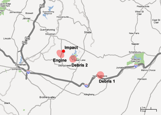
Look at the map scale, quite a large debris field for a plane which supposedly lost control and crashed, don't you think?rs said:Um, what is your point?
Evidence.
rs
Dagobah Resident
Not really unless you start making assumptions about the actual effect of the wind on the debris, on exactly what that debris was and lots of other assumptions which were not stated. Either way the original post only showed a graphic and did not attempt to put that graphic into any context. There was no discussion of other background facts.quite a large debris field for a plane which supposedly lost control and crashed
Don't misunderstand, I think it highly likely that 93's demise was "assisted" in some way because the debris field is so spread out, but I'm not sure that the graphic and wind records add any value beyond things we already know or suspect strongly.
The latest need by the Media to reinforce the Flight 93 "lets roll" story line with the impending release of a "major motion picture" only shows how even this part of the whole 9/11 story is unraveling and thus the entire story continues to unravel.
Well, if the Engine was found WNW of the papers and files found in New Baltimore, I'd say that's a pretty powerful wind...rs said:Not really unless you start making assumptions about the actual effect of the wind on the debris, on exactly what that debris was and lots of other assumptions which were not stated. Either way the original post only showed a graphic and did not attempt to put that graphic into any context. There was no discussion of other background facts.quite a large debris field for a plane which supposedly lost control and crashed
from http://www.flight93crash.com/"Eight miles away in New Baltimore, Melanie Hankinson said she found singed papers and other light debris from the crash, including pages from Hemispheres Magazine, United's in-flight magazine. Stoe said authorities initially insisted crash debris could not have traveled over a mountain ridge more than eight miles from the crash.
D
Darren
Guest
Just putting the data out there. Wind direction specifies the direction the wind is coming from.
A
Arlo_usa
Guest
Windspeed that day, in that area, was 10 MPH. Not enough to lift a newspaper, let alone debris found.
A local sheriff, whose name I forget, was quoted as saying debris was found at least 5 miles from crash site.
Obviously, the impact did not send debris flying five miles.
A local sheriff, whose name I forget, was quoted as saying debris was found at least 5 miles from crash site.
Obviously, the impact did not send debris flying five miles.
anart
A Disturbance in the Force
Ahh, okie doke - thanks for the correction.Darren said:Just putting the data out there. Wind direction specifies the direction the wind is coming from.
rs
Dagobah Resident
From http://www.weather.com/glossary/w.html
What is missing on the diagram is the measured (via radar) flight path of Flight 93, so a huge bit of data is missing. As far as the engine being where it was, since we don't know the flight path, particularly at the end when it would be expected to be "uncontrolled", just pointing out the distance from impact does not add value because too many other factors are not known.
Back to the original post, it does not make a point.
As far as blowing debris 8 miles with a 10 mph wind, again what is missing is a lot of actual data. At what altitude was the debris released? What was the wind speed at that altitude? (The reported data is at ground level, and is not relevant to the debris.) What was the debris and what is its expected aerodynamic performance? (I.e. a rock is likely to be in ballistic free-fall, a magazine cover is not.)
What is the local geographic topology when overlaid on the above map? There was a statement about a mountain. Where is it on the picture? (Topo maps of the area can be obtained from http://www.dcnr.state.pa.us/topogeo/gismaps/topos.aspx by following the "Download digital raster graphics (DRGs) of Pennsylvania from PASDA" link. The specific file is ftp://www.pasda.psu.edu/pub/pasda/drg24k/stoystown_pa.zip and it contains a large tif file.)
Personally my theory is that the separate debris fields represent more than one missile that was fired at the plane to shoot it down. The first one did 'light' damage but left the airframe mostly intact. The second one left the plane out-of-control in a fatal dive and it "flung" an engine off as it was spiraling out of control.
(Lest one question whether or not a plane can fly with its skin compromised, recall the Air Aloha 737 that had the entire top of the plane peel off like a pop-top cat food can. It landed "safely", and when you look at the photos, it feels like a genuine miracle. The entire top of the plane is simply missing and the people are sitting out in the open.)

Therefore a wind of WNW is blowing fromWNW. This, ironically, supports the debris field rather then refutes it.WIND DIRECTION
The direction from which the wind is blowing. For example, an easterly wind is blowing from the east, not toward the east. It is reported with reference to true north, or 360 degrees on the compass, and expressed to the nearest 10 degrees, or to one of the 16 points of the compass (N, NE, WNW, etc.).
What is missing on the diagram is the measured (via radar) flight path of Flight 93, so a huge bit of data is missing. As far as the engine being where it was, since we don't know the flight path, particularly at the end when it would be expected to be "uncontrolled", just pointing out the distance from impact does not add value because too many other factors are not known.
Back to the original post, it does not make a point.
As far as blowing debris 8 miles with a 10 mph wind, again what is missing is a lot of actual data. At what altitude was the debris released? What was the wind speed at that altitude? (The reported data is at ground level, and is not relevant to the debris.) What was the debris and what is its expected aerodynamic performance? (I.e. a rock is likely to be in ballistic free-fall, a magazine cover is not.)
What is the local geographic topology when overlaid on the above map? There was a statement about a mountain. Where is it on the picture? (Topo maps of the area can be obtained from http://www.dcnr.state.pa.us/topogeo/gismaps/topos.aspx by following the "Download digital raster graphics (DRGs) of Pennsylvania from PASDA" link. The specific file is ftp://www.pasda.psu.edu/pub/pasda/drg24k/stoystown_pa.zip and it contains a large tif file.)
Personally my theory is that the separate debris fields represent more than one missile that was fired at the plane to shoot it down. The first one did 'light' damage but left the airframe mostly intact. The second one left the plane out-of-control in a fatal dive and it "flung" an engine off as it was spiraling out of control.
(Lest one question whether or not a plane can fly with its skin compromised, recall the Air Aloha 737 that had the entire top of the plane peel off like a pop-top cat food can. It landed "safely", and when you look at the photos, it feels like a genuine miracle. The entire top of the plane is simply missing and the people are sitting out in the open.)
E
Enlightened1
Guest
The original report on 9-11 was that there was a bomb on board. Perhaps the small Learjet owned by a company of Warren Buffet was there to trigger the device. Bush went directly to Offut that day I believe, if I'm not mistaken.
It is my contention that the alleged "hijackers" were people (not necessarily Mid Easterners) playing out a role in what they thought was a war game. They had no clue it was a real event and that they were on their way to meet Allah that day.
The only ones that can answer those questions seem to be embraced by the new Democratic Congress that won't impeach.
S
sagittarian
Guest
Please ignore the mispelling of my login "sagittarian". It was not intentional. I have no way or correcting my login name.
On 01/20/06, noise wrote in the Pentagon thread:
Rumsfeld himself admitted that the plane over pennsylvania was shot down. Maybe your partially correct, "the military" in terms of how we know, love and understand it didn't shoot it down, but it was obviously shot down.
http://www.youtube.com/watch?v=k0v0_HDwg84&eurl=
I looked at that video. I played it over and over many times. For the life of me I cannot read into it that the plane was shot down. What I hear Rummy saying is "...if we imagine what kind of world we would face IF the people who [did this and that, listing serveral incidents] and [who] attacked the United States in New York, shot down the plane..." The [who] is implied in the speech. I inserted that for clarity. Rummy did NOT say "... and attacked the United States in New York AND shot down the plane..." In his speaking, there is an implied comma after the series of incidents. It is as though he said, "...what kind of world we would face if the people who ... attacked the United States in New York HAD ALSO shot down the plane..." There is no admission here that the plane was shot down. It sounds more like WHAT IF scenarios in an attempt to convery the kind of trauma we would be in IF something like that had happened. What really needs to be amplified here, for my benefit, is what question he was answering, if any, or what his purpose was in bringing up this kind of scenario. A complete transcription of the interview would be most helpful. But to pick out one phrase, "shot down the plane", and then carry on like it actually happened seems way out of line to me. What other evidence is there besides this that one could rely on to say the plane was really shot down?
I am currently reading the Timeline of 9/11 at
http://www.cooperativeresearch.org/proj … 11_project
There is also a 4-hour independent documentary aired recently on Link TV that I taped. Has anyone in this forum read the Timeline or viewed the documentary? What are your reactions and responses to the Timeline and documentary?
2/7/2007: 9/11: Press for Truth and Paul Thompson Interview Shown on Link TV Starting Feb. 10
9/11: Press for Truth, the recent documentary partly based on the 9/11 Timeline, will be shown repeatedly on Link TV between Feb. 10 and Mar. 10. Check Link TV for show times. A 30-min. interview with Paul Thompson, creator of the 9/11 Timeline, will also be aired. Thompson is interviewed by Peter Coyote, a political activist and actor in over 90 films.
I do find this in the Timeline:
Accounts of the plane making strange noises -
Laura Temyer of Hooversville: “I didn’t see the plane but I heard the plane’s engine. Then I heard a loud thump that echoed off the hills and then I heard the plane’s engine. I heard two more loud thumps and didn’t hear the plane’s engine anymore after that.� (She insists that people she knows in state law enforcement have privately told her the plane was shot down, and that decompression sucked objects from the aircraft, explaining why there was a wide debris field.) [Philadelphia Daily News, 11/15/2001] http://web.archive.org/web/200111160938 … HOT15c.htm
However, since she was told the story of the plane being shot down, her account is hearsay.
Other reports say people "heard" what sounded like to them as missles going overhead, then a loud explosion. In my view, a plane going down could emit a high-pitched noise (doppler effect) that might make it sound like a missle, and that kind of noise could travel and bounce enough to make it sound like it was in one's immediate vicinity even though it was miles away.
And yet another account has a man "seeing" the plane several hundred feet off the ground, and to him the plane was intact even though he could only see the top side of the plane, and it turned end over end before it disappeared out of sight.
If a missle had hit the plane, it would have demolished large sections of it and the eye-witness account above would most likely have reported smoke coming from the plane as well, which he did not report. In fact, all reports of "loud bangs" before seeing the plane suddenly bank and head for the ground were absent any sightings of smoke coming from the plane.
My conclusion is that the plane was not shot down. There is insufficient eyewitness accounts to corroborate such a story. But obviously, I have a lot more to read and I'm still not finished with the Link TV documentary.
John
D
Darren
Guest
noise said:Rumsfeld himself admitted that the plane over pennsylvania was shot down. Maybe your partially correct, "the military" in terms of how we know, love and understand it didn't shoot it down, but it was obviously shot down.
http://www.youtube.com/watch?v=k0v0_HDwg84&eurl=
What Rumsfeld said has no bearing on what happened, though that's not to say it isn't significant. In your quote, you missed out the end of what Rumsfeld said, which makes things clearer:sagitarrian said:I looked at that video. I played it over and over many times. For the life of me I cannot read into it that the plane was shot down. What I hear Rummy saying is "...if we imagine what kind of world we would face IF the people who [did this and that, listing serveral incidents] and [who] attacked the United States in New York, shot down the plane..."
[...]
A complete transcription of the interview would be most helpful. But to pick out one phrase, "shot down the plane", and then carry on like it actually happened seems way out of line to me. What other evidence is there besides this that one could rely on to say the plane was really shot down?
"I think all of us have a sense if we imagine the kind of world we would face if the people who bombed the mess hall in Mosul, or the people who did the bombing in Spain, or the people who attacked the United States in New York, shot down the plane over Pennsylvania and attacked the Pentagon, the people who cut off peoples' heads on television to intimidate, to frighten – indeed the word 'terrorized' is just that. Its purpose is to terrorize, to alter behavior, to make people be something other than that which they want to be."
Probably best then, to continue reading, including the information already posted on this forum, before presenting "conclusions" on subjects that have been discussed here and addressed in articles on the SOTT website.sagitarrian said:My conclusion is that the plane was not shot down. There is insufficient eyewitness accounts to corroborate such a story. But obviously, I have a lot more to read and I'm still not finished with the Link TV documentary.
There was also no need to duplicate this post in another thread.
S
sagittarian
Guest
Ruth wrote: "Is this another 'catherder', then?
What's a "catherder"? I can't find that word anywhere.
What's a "catherder"? I can't find that word anywhere.
Trending content
-

-
 Thread 'Mass Shooting at Bondi Beach, Sydney, targets Jews celebrating Hanukkah'
- Rhythmik
Replies: 135 -
Thread 'Coronavirus Pandemic: Apocalypse Now! Or exaggerated scare story?'
- wanderingthomas
Replies: 30K