Floods & Landslides

I just thought I'd post this news event because it comes not long after the 15-year-old girl from Maine, Kristen Byrnes, predicted an end to Australia's drought. Given some of the other things she predicted, perhaps it's time we took them very seriously. The original article can be found here.


Nine dead as thousands forced to evacuate

Source: AAP

June 10, 2007, 4:00 pm

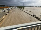
THOUSANDS of residents in the NSW Hunter region have been urged to abandon their homes ahead of a torrent of floodwater expected to hit the region tonight.

The death toll from the three days of wild storms reached nine today as police found the body of 45-year-old Adamstown man, Wayne Bull, who was swept into a stormwater drain in the Newcastle suburb of Lambton after getting out of his car on Griffith Road on Friday night.

At the peak of Friday's wild weather, five members of the same family were swept to their deaths when a section of the Old Pacific Highway collapsed under their vehicle and it was hit by a "wall of water'' at Somersby, near Gosford.

The bodies of 30-year-old Adam Holt and his long-term partner Roslyn Bragg, 29, were recovered from Piles Creek today, while the bodies of their two daughters, Madison and Jasmine, aged two and three, and their nephew Travis Bragg, nine, were recovered yesterday.

All five bodies have now been taken to Newcastle morgue for formal identification.

Further north, Robert and Linda Jones were killed when their vehicle was washed off a flooded bridge at Clarence Town, while a 29-year-old Heddon Greta man died when a tree fell on his ute at Brunkerville, Lake Macquarie, about 6pm (AEST) yesterday.

Financial assistance

Prime Minister John Howard today offered additional financial support, and his condolences, to people affected by the storms.

"I know I speak for every Australian in saying that the country is thinking of you and we're heart broken by the loss of lives and the tragic circumstances in which a number of people have lost their lives ... (it's) the, tragically, human side of something such as this,'' he said.

"It is an immense disaster.''

While the torrential downpours and gale-force winds of Friday had eased by today, the focus turned to the dangers posed by floodwaters, with the Hunter Valley centres of Maitland and Singleton preparing for the worst.

Evacuation ordered

The State Emergency Service (SES) this afternoon issued an evacuation order for residents of central Maitland, South Maitland and Lorne following revised predictions that flood waters would peak at 5cm above the levee by 9pm today.

Residents are being advised to be out of their homes by 8pm, SES spokesman Philip Campbell said.

"The revised flood peak of 11.4 metres is expected by 9pm and that will cause the levee to over-top,'' Mr Campbell said.

About 5,000 people have been advised to evacuate in the Maitland and Singleton areas since yesterday.

Lower Hunter Local Area Commander, Superintendent Desmond Organ, said police were advising residents not to delay leaving the area, adding that security would be provided for vacant properties.

Evacuation centres have been set up to provide welfare assistance, first-aid, food and transport.

Sandbagging underway

Sandbagging operations were underway at Branxton to protect homes near the river ahead of its expected peak at 6pm today, while the New England Highway to Branxton and Anvil Creek Bridge were cut to all traffic bar emergency service vehicles.

Meanwhile, Premier Morris Iemma said the damage in Newcastle was worse than that caused by the city's 1989 earthquake.

"Construction sites and scaffolding, debris on roads, abandoned cars, homes that were damaged, trees having fallen on homes, extensive damage. It was quite disbelieving,'' he told the Seven Network.

The water also was causing havoc for utilities, with sewage flowing untreated into the ocean from plants across Sydney and the Hunter Valley.

Power cuts

More than 100,000 homes of the Lower Hunter and Central Coast are still blacked out, along with 5,000 Sydney residences, and power may not be fully restored until later this week.

Public transport is returning to normal across Sydney but storm-ravaged Newcastle and the Central Coast are still experiencing disruptions.

Householders affected by the wild storms and floodwaters have been urged to contact their insurance companies to speed up property damage claims.
 
Chamoli, Uttarakhand: Heavy monsoon rains have triggered a landslide, blocking the Badrinath National Highway in Chamoli district. The incident occurred early this morning, causing significant disruptions to traffic and posing safety risks to commuters and residents in the area.
Impact on Traffic and Commuters
The landslide has resulted in the complete blockage of the highway, stranding numerous vehicles and travelers. Local authorities are advising commuters to avoid the area and seek alternative routes. Emergency services are on-site, working to clear the debris and restore the flow of traffic as soon as possible.
Authorities’ Response and Safety Measures
In response to the landslide, local authorities have deployed teams to manage the situation and ensure the safety of those affected. Measures are being taken to prevent further incidents, including monitoring weather conditions and reinforcing vulnerable sections of the highway.

The heavy rains are part of the ongoing monsoon season, which has brought widespread rainfall to the region. Residents are urged to stay updated on weather forecasts and heed any advisories issued by local authorities to stay safe.

Germany experienced the wettest twelve-month period since measurements began in 1881
Wetter und Klima - Deutscher Wetterdienst - Presse - Aktuelle Auswertung des Deutschen Wetterdienstes
Date 03.07.2024
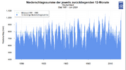
Offenbach, July 3, 2024 – Never since measurements began in 1881 have there been such rainy consecutive twelve months in Germany as in the period from July 2023 to June 2024. (Fig. 1) This is reported by the German Weather Service ( DWD ) after evaluating its nationwide measuring stations. Dr. Frank Kaspar, Head of Hydrometeorology at the DWD : “This record was achieved even though none of the past twelve months stood out as a record month.” According to DWD calculations, an average of around 1070 litres per square meter fell across Germany in the period from July 2023 to June 2024. In comparison, the long-term average for the reference period 1961-1990 is around 789 litres per square meter per year.

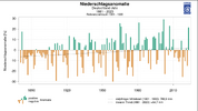
A look at the DWD ’s national climate archive shows that over the past ten years, annual rainfall totals have predominantly been below average. (Fig. 2) However, if you look at the time series since measurements began in 1881, the data show a slight increase in annual precipitation in Germany. However, according to the DWD, there is always a change between dry and wet periods. Kaspar: "The precipitation is characterized by a high degree of variability both from year to year and over longer periods." (Fig. 3) The dryness of recent years has now been replaced by a very wet 12-month phase, which has further reduced the precipitation deficit with each passing month. Figures for the press release: Fig. 1

Screenshot 2024-07-10 at 11-15-23 Weather and climate - German Weather Service - Press - Curre...png
Precipitation total in Germany for all 12-month periods since 1881

Screenshot 2024-07-10 at 11-17-22 Wetter und Klima - Deutscher Wetterdienst - Presse - Aktuell...png
Deviation of the annual mean precipitation in Germany since 1881 from the average of the reference period 1961 - 1990.
Source: www.dwd.de/zeitreihen

Screenshot 2024-07-10 at 11-18-57 Weather and climate - German Weather Service - Press - Curre...png
The graphic shows the variability of precipitation in Germany with changes from wet to dry phases. The value for the previous 12-month period is shown.

The graphic shows the variability of precipitation in Germany with changes from wet to dry phases. The value for the previous 12-month period is shown in each case.

Note to the editors
The three figures can be found in printable resolution as an appendix to this press release at www.dwd.de/presse

Expectations of flooding in Scotland could bring 25 to 45mm in the low land and 50 to 60mm possible in places that are mainly over high ground.


Beryl’s Tornado Outbreak, By The Numbers
July 9, 2024 Video
Beryl brought more than just deadly wind, rain, and flooding. It also spawned an unusually high number of tornadoes.
 
Illinois dam fails, residents told to evacuate area
NASHVILLE, Ill. (KTVI) – Thunderstorms with heavy rains and tornadoes rattled the Chicago area and elsewhere in the Midwest, overtopping a dam Tuesday in southern Illinois, cutting power to hundreds of thousands, and even sending weather forecasters scrambling for safety. A woman in Indiana died after a tree fell onto a home.

Water overtopped a dam near Nashville, Illinois, sending first responders to the flooded area to make sure everyone got out safely, officials said. There were no reports of injuries in the community of 3,000 southeast of St. Louis, but crews were sent to a home where a woman reported water up to her waist, said Alex Haglund, a spokesperson for the Washington County Emergency Management Agency.

Earlier, the Washington County Emergency Management Agency EMA advised residents south of the Nashville City Reservoir, located outside St. Louis, Missouri, to evacuate their homes immediately. Residents were told the community center in Nashville was open for shelter.

“The Failure of the Nashville dam is imminent. Please evacuate your home at this time. If you are in the grey box, you need [to] evacuate now!” the agency said Tuesday morning, referring to the shaded area of an online map.

Screenshot 2024-07-16 at 20-08-13 snapshot-2024-07-16T085304.341.jpg (WEBP Image 1920 × 1080 p...png

EMA spokesperson Alex Haglund said a portion of the dam failed early Tuesday, but it wasn’t clear if it was a break or an overtopping. A “secondary failure” happened later in the morning when the dam was overtopped.

The National Weather Service also announced Tuesday morning that Washington and Clinton County have upgraded from a flash flood warning to a considerable flash flood.

The upgrade, according to the National Weather Service, means the flash flooding is a more dangerous situation than usual.

The National Weather Service said 5-7 inches (12.7-27.8 centimeters) of rain fell over an eight-hour period. Additional heavy rain was in the forecast. An 11-mile stretch of Interstate 64 in the Nashville area was closed because of flooding.

“We did have an area of rotation,” meteorologist Zachary Yack said, referring to extreme rotating wall clouds. “And it kind of developed right near our office here in Romeoville, Illinois. … We went and took cover. We have a storm shelter here.”

A 44-year-old woman died in Cedar Lake, Indiana, in the southern fringes of the Chicago area, the Lake County coroner’s office said.

Additionally, U.S. Highway 50 in Lebanon, Illinois, between State Route 4 and Belleville, Illinois, has been closed due to the flooding.

Illinois State Police say they have responded to three property damage crashes in the Washington County area. It is unknown if these crashes are flood-related.

🪽👀


An impressive landside at La Rivière, near Rovon, France

On 25 July 2024, a major landslide occurred in the La Rivière quarry near Rovon, Isère. This landslide, which occurred around 7pm local time, crossed the D1532 road. At the time of writing, it is unknown whether anyone was on the road at the time of the landslide.

The failure was captured in a remarkable video, which was posted on Twitter:


There is an excellent report, as well as many images, on the Franceblue website.

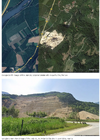
The location of the quarry is (45.2139, 5.4907). Here is a Google Earth image of the site:-

Screenshot 2024-07-26 at 20-07-40 The landslide of July 25 2024 at the La Rivière quarry in Fr...png
The image in the tweet below, taken from Le Soir, shows the aftermath of the landslide. It appears to have affected a large amount of material beyond the edge of the quarry:-

But note the flat surface ahead of the landslide scar. To me, this appears to be a pre-existing discontinuity – perhaps a joint or fault – extending into the actively mined area. This plane of weakness appears to have been the rupture surface.

Efforts are currently underway to search for and rescue people trapped under the rubble.

Text © 2023. The authors. CC BY-NC-ND 3.0
Unless otherwise noted, images are subject to copyright. Any reuse without the express permission of the copyright holder is prohibited.


:shock:
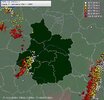
A large rain shower is approaching Paris. Unfortunately, the trajectory leaves little doubt.
 
Earth opening up news - a big landslide (30m high and 600m long) has blocked off the Chilcotin River, forming a lake behind it. Local residents have been evacuated, and now the district is waiting for the water pressure in the lake to blow out the earth dam.

 
Earth opening up news - a big landslide (30m high and 600m long) has blocked off the Chilcotin River, forming a lake behind it. Local residents have been evacuated, and now the district is waiting for the water pressure in the lake to blow out the earth dam
The latest update of this event
“I cannot stress enough how extremely unsafe and unstable the valley is right now,” B.C.’s Minister of Emergency Management, Bowinn Ma, said at a press conference on Monday.

“There is a risk of further landslides both upstream and further downstream of the dam.”

She added that people along the Chilcotin River and the Fraser River should stay in contact with their local governments and First Nations.

“We need people to stay off of the Chilcotin and Fraser Rivers and away from the riverbanks,” Ma said.

“It is dangerous to be by those rivers right now.”

Videos taken on Monday morning at the site of the dam show water flowing over the top of the site

 
Is one of those signs, the piramid is like 1000 years old and it's just collapsed this year. Of course, it could have broken off in other times but, not in the last century nor this one, I have memory of anything similar happening. Research and sculpture unearthing of this archeological area was at the beginning of the last century

Purepecha pyramid collapses in Ihuatzio
“On the night of July 29, 2024, due to the heavy rains that have fallen in the basin of Lake Patzcuaro, with an accumulation above the expected average rainfall, there was a collapse in the central part of the south facade of one of the pyramidal foundations of the Archaeological Zone of Ihuatzio. The high temperatures, previously registered in the area, and the consequent drought caused cracks that favored the filtration of water into the interior of the pre-Hispanic building”, informed the federal INAH on August 7.


1724119874312.png
 
A massive deluge of precipitation inundates areas of Paryatan Bhawan, India, resulting in a significant landslide near a power station


WhatsApp-Image-2024-08-21-at-6.17.11-PM.jpeg
Agartala: August 21: The Meteorological Department has issued a warning of heavy to very heavy rainfall in Tripura for the next five days. Continuous rainfall has severely disrupted normal life. According to the Meteorological Department’s report, the highest rainfall so far has been recorded at 182 mm in Agartala, and the lowest at 18 mm in Khumlung.

A red alert has been issued for the next 24 hours in Sepahijala and West Tripura districts, warning of thunderstorms and heavy to very heavy rainfall. An orange alert has been issued for all districts of the state for the next 24 hours.

Normal life has been significantly affected due to rainfall throughout the day. The maximum temperature today was recorded at 27 degrees Celsius, and the minimum at 25 degrees Celsius. This morning, the minimum temperature was near normal in all districts.

Rainfall measurements reported by the Meteorological Department include:
  • Agartala: 182 mm
  • AD nagar: 175 mm
  • Lembuchhara: 104.2 mm
  • Bodhajongnagar: 59 mm
  • DM Office: 123 mm
  • Secretariat: 95 mm
  • Khumluwng (West Tripura): 18 mm
  • Sonamura: 47 mm
  • Bishalgarh: 40.6 mm
  • Bishramganj: 56 mm
  • Gajaria: 35.8 mm
  • Mohanbag (Sonamura, Sepahijala): 36 mm
  • Khowai: 82 mm
  • Udaipur: 41.2 mm
  • Amarpur: 93.2 mm
  • Karbuk (Gomati): 153 mm
  • Belonia: 72 mm
  • Bagafa (South Tripura): 74.5 mm
  • Panisagar: 45 mm
  • Kanchanpur: 44.2 mm
  • Kadamtala: 59 mm
  • Nutan Bazar (North Tripura): 128 mm
  • Kumarghar: 50 mm
  • Kailashahar (Unokoti): 51.2 mm
  • Chawmnu (Dhalai): 62.1 mm
  • Gandachhara: 109.5 mm
  • Kamalpur: 79 mm
  • Manughat: 56.2 mm

Paryatan Bhawan India
 
A deluge hit the Pyrenees, causing significant flooding. The village of Etsaut found itself under 2 meters of rock! The results in picture
175 mm in the Pyrenees.

pluie-sud-ouest-7septembre2024.png
Cumulations of rain over 48 hours in the south-west to Saturday 7 September 2024 at 12 noon – Express weather

These intense stormy rains quickly caused problems in the Pyrénées-Atlantiques and the Hautes-Pyrénées, where traffic became difficult in the mountains. Floods multiplied and the water folded down the rocky slopes. As such, the RN134 road collapsed in the municipality of Urdos. On the Spanish side, a road also collapsed, causing the closure of the Bielsa-Aragnouet tunnel.

Road collapsed at Urdos (64) this Saturday, 7 September 2024

Crushed road to Urdos (64) this Saturday, 7 September 2024 – Izaki Echaniz

Many flooded rivers​

The calm began on Saturday morning but the flood of the night led many Pyrenean streams into flood. This was the case, for example, with the Neste d'Aure, whose flow was very impressive in Saint-Lary-Soulan.


The Gave de Pau also experienced an important flood this Saturday morning. In Lourdes, its level rose to 3.20 meters around 8 hours, approaching less than 30 centimeters from the October 2012 reference flood. As a result, the sacred cave was flooded and closed to the public. She was able to reopen on Saturday night after the collapse.

Screenshot 2024-09-07 at 20-22-42 Flood in the Pyrenees floods and heavy damage on 7 September...png
Videos Gifs👆👇

The village of Etsaut devastated

In the department of Pyrénées-Atlantiques, the Gave d'Aspe experienced a particularly severe flood in the early morning of Saturday. It was the small village of Etsaut, inhabited by about fifty inhabitants a year, which paid the heaviest price. One of the streams that feeds the Aspe Gave – the Sadum – turned into a fury torrent.

Screenshot 2024-09-07 at 20-25-17 Flood in the Pyrenees floods and heavy damage on 7 September...png
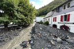
The water receded during the day, giving way to scenes of desolation. Indeed, the remarkable flow of Sadum Creek carried large quantities of rock and land that invaded the heart of the village. Some vehicles have almost been completely covered by rubble.

etsaut-crue-degats.png
Big damage to Etsjing (64) after the flood this Saturday, September 7, 2024 – Izaki Echaniz

In the centre of the village, some dwellings and shops were totally inaccessible due to the accumulation of rubble carried by the furious water. In some places, more than two meters of rock were deposited, leaving the inhabitants stunned. It is gratifying that there have been no casualties.

etsaut-crue-degats2.png
Two metres of rock at Etscape (64) after the flood this Saturday, 7 September 2024 – Izaki Echaniz

The disrupted sequence is not over with the continuation of the thunderstorms and heavy rains this Saturday evening and Sunday. Check out our 10-day forecast.

⚡ Heavy storms have hit eastern Burgundy and are now affecting Franche-Comté. Arcus in Mont-sous-Vaudrey in the Jura. ( © Maxime Stievenart)

Magnificent stormy atmosphere observed, this Saturday, around 7 p.m., in the North-West of @Indre36, near Châtillon-sur-Indre, in front of an active storm line ⛈️ . #orages #orage @AssoMeteoCVDL@KeraunosObs

Association Météo Centre - Val de Loire @AssoMeteoCVDL
[Direct]This Saturday evening, around 7 p.m., an active storm line is moving up from the South-West of our
@RCValdeLoire . It is moving from Indre-et-Loire to Loir-et-Cher, passing through a North-West area of Indre. Stay careful!
GW46joZWwAA_zzx.jpeg

 
Very impressive video of the landslide from the Col de l'Encrenaz in Haute-Savoie, near Morzine, taken apparently this Tuesday, September 10. Turn on the sound!Video by Stéphane Hoerner, via the Facebook account of "T'es de Chamonix quand..."
Correction, if it is indeed the Col de l'Encrenaz, the one in the video is located next to Vallorcine, at an altitude of 2579 m. And not its homonymous "little brother" located in Chablais, and pointing at an altitude of 1433 m!

It’s the Bérard valley, not Morzine...

Yes I know, but the Morzine resort is still a little better known for locating the video...

Tropical Storm #Francine is causing flooding concerns on the Gulf Coast. It is trending to become a hurricane and is expected to hit the region on Wednesday, September 11.

 
The Northern and the Eastern part of Austria, including Vienna, re affected by severe storms and flooding, In the counto of Niederösterreich (Lower Austria) disaster alert had been given. It looks very dramatic. Very very small rivers became heavy streams.
There is no trainservice at the moment from Vienna to Linz and Salzburg, hundreds and hundreds and hundreds of people on Viennas Mainstation trying to find a way home. I also was trying to catch a train to Salzburg but it was impossible. All down. The situation changed every half an hour, jumping from hope to disappointment. But in between all these nasty circumstances there is always something good, because people are very nice to each other.
I live 50 km south of Vienna, we had many rain but no floods. We have a river that normally has no water, when I crossed it today it had become a heavy river.
I enclose an article of a newspaper where one can look at some of the pictures in Vienna. The most impressing situation (at least for me) was that the small Wienfluss has got so much water . .. Also Subways U6, U2 and U4 were affected as well as other parts of public transport. Really heavy!!
Unfortunately obviously one person died, a lot had to be evacuated. I have not heard or can remember of a situation like this in Vienna.
I know that there are also really problems in Czech Republic, esp. Brno.
This is the link with some pictures, the translated text is beneath.

Vienna river overflows its banks

Houses of 100 people in Vienna-Penzing evacuated!

Flooded streets, masses of water entering homes: The fire brigade had to evacuate 13 properties in Vienna-Penzing.
Continuous rain and storms also put a strain on the fire brigade in Vienna. The Vienna Fire Brigade has already dealt with more than 1,100 incidents in the city. Fallen trees, broken branches, water ingress into buildings, cellars and underground car parks kept the emergency services on their toes.

In Vienna's Penzing district, an absolute disaster scenario unfolded: the Wien River burst its banks in the Ludwiggasse area and the first houses were flooded. ‘Some buildings can only be reached by boat. People had to be evacuated here in the early hours of the morning,’ confirmed the fire brigade and issued a warning:

‘Avoid unnecessary journeys or spending time outdoors today (trees, parks) and stay away from flooding waters!’

Around 13 properties - including single-family homes, terraced houses and apartment blocks - were evacuated by the fire service. The 100 or so residents affected were initially accommodated with friends, acquaintances and relatives - for how long is currently still completely open. The fire brigade is still expecting a very high volume of operations and has therefore called in additional personnel.

Flood alert in Vienna! Several routes closed
 
More about Storm Boris:
As feared, Storm Boris is wreaking havoc across parts of Central Europe with major flooding becoming widespread throughout the region. Here’s a 50-hour visible satellite and radar loop courtesy of
@zoom_earth

Hereafter just in Poland:
Dramatic situation in Central Europe with major floods following torrential rains. Here, the streets of Głuchołazy (Poland) transformed into torrents. 🌊 (© Tomasz Śliwiński)

Kłodzko in Poland is already flooded. It's catastrophic. The local authorities are warning residents that another flood wave is on it's way and that it will be larger than the first one....

First aerial views of extreme flooding today in Kłodzko and Opole, Poland#powódz #flooding

In Czech Republic:
Many towns in Central Europe are flooded this September 15, here Jeseník in the Czech Republic. Several victims have already been reported. (© Kokos Jojos)

I think we are about to witness some dramatic events in Central Europe in the very coming days. And let's not forget the huge quantities of snow falling on the Alps!
Take good care of you @naorma and everyone living in this very large area.
 
Take good care of you @naorma and everyone living in this very large area.
Thank you very much! In fact I am really very disturbed about whats going on. Highways under water, a village 25 km away from me has to boil their drinking water, shops are overflooded there, houses damaged and even in Vienna the Hofburg is threatened with water. We all cannot remember having had such a situation before. And I think my parents and grandparents would have told me about such a disaster.
Tomorrow we are supposed to get more rain and on Tuesday it should be over. But this is not the end. Temperatures will rise and the snow is melting and there will be another rush of water coming.

But on the other hand I get tears in my eyes when I see how people help each other. Offering shelter for horses, i.e. Or a small hotel that offers free apartments for some days. When I was talking to a friend I told her I will go out and talk to people: "Why can we not be so kind and helpful to each other without a catastrophe?"

I just add some more pictures . . .
 

Attachments

  • kaizar.jpeg
    kaizar.jpeg
    241.7 KB · Views: 12
  • hofburg.jpeg
    hofburg.jpeg
    86 KB · Views: 12
  • pferde.jpeg
    pferde.jpeg
    114.3 KB · Views: 10
  • railway station near st. pölten.jpeg
    railway station near st. pölten.jpeg
    146.2 KB · Views: 10
  • knoten guntramsdorf.jpeg
    knoten guntramsdorf.jpeg
    428.6 KB · Views: 12
Back
Top Bottom