Gulf of Mexico Loop current broken

I'm made a video and will post it with the images from July-August 29th. It does appear that the currents did go back to normal for a spell in early August. Of course this isn't expert fact, just my perspective of what I think happened. The video is 4 min. 12 seconds.

Here is the yahoo link: http://au.video.yahoo.com/watch/8165755/21662277

The youtube link: http://www.youtube.com/watch?v=UEPm4Oy2FEM

I wonder if I did it right. The images are only showing the topographical heights but not the direction of the current. Should I see if I can find a way to show the movement of the waters? I'm not very familiar with the site or anything about the various options of how to view the maps.

The images are 5 seconds with a 1 second fade to the next image.

Hope this info helps those who know more about the subject.
 
Look at argo.colorado.edu/~realtime/welcome click the realtime velocity viewer and enter what data you want to see.
 
Hi Neil,

Thanks for the tip. It certainly looks like the gulf stream is entirely broken. Instead of the current flowing up between Cuba and Florida it looks like it is going around southern Cuba entirely.

http://argo.colorado.edu/~realtime/gifs_tmp/global_vel/gmt.29554.gif

Edit: I found the water direction maps and made another video.

Here is the yahoo video/audio link: http://au.video.yahoo.com/watch/8167459/21667455

The youtube link (audio disabled): http://www.youtube.com/watch?v=WE_q0etEs4o

I cut the images to 4 seconds before a 1.25 second fade. The whole video is 3min. and 18 seconds. I added images from the first of March, April, May and June to the previous content.
 
Personally, I like this mode better. It gives you a clearer picture of the current flow.
gmt.4507.gif

As you can see, there is still kind of a loop current, but it is not flowing particularly strongly.
go2 said:
Does anyone have confirmation or sourcing on the 10 degrees Celsius year over year temperature drop of water in the Gulf Stream? If that number is accurate, it seems a massive disruption in energy flow into the North Atlantic.
I've been very suspicious of this 10 degree thing. I haven't been able to find much about it unless the temperature has dropped 10 degrees in very localized spots only. I did find a site where you can play around with the data and look for anomalies._http://www.nsof.class.noaa.gov/saa/products/search?sub_id=0&datatype_family=SST50&submit.x=16&submit.y=11 I'll give you a few samples. Check results for August 23-24 for 2008, 2009, and 2010. You may have to change the days slightly to get it to display. It helps to resize the map to display only the Northern Atlantic. While I'm not seeing 10 degrees, there does seem to be a clear and gradual trend of the warmer water retreating from Europe, as Laura was seeing on the DEOS chart. Put the images side by side and you'll notice a small, but noticiable retrenchment of the warmer colors.
Now perhaps this can be explained as intra-seasonal fluctuation, but I'm leaning more toward the idea that this is more evidence that this process has been going on for some time, and the oil may have just accelerated it. Maybe more trends can be discovered with a more thourgh analysis, but it's getting late for tonight.
 
Hi again Neil,

I got the images and will put together something tomorrow. This is the information I was initially trying to get.. third times a charm I guess. :)

I got all the images and took two for may, 4-5 for June then July 1st - Aug. 29th (maybe I'll get the 30th tomorrow). I'll speed it up though without the fading so people can get an idea of the motion, and they won't have to wait 3-5 minutes to get it all.

I hope this is helpful to anyone interested. Also if you want Laura, if you get a chance, or someone there gets a chance to play around with DEOS chart(? I looked at the link and didn't grasp what (you) Neil was talking about clearly) and wants some images put together I'd be glad to download and put together a time-line of that series of images as well, if such is the case.

I'd thought I had a clear grasp on all of this and thought putting it together in images would be a good idea, yet at this point, I'm not at all sure. I do however think the images I finally have on hand give a much better picture of how the water is moving in the gulf.
 
Sorry for the confusion Balberon.

The DEOS chart is what is linked to off the SOTT page under "Gulf Stream Watch." Laura made a post a few pages back in the Mother of All Gushers thread about how the Gulf Stream was gradually winding down. There is an animation on the site that shows the Gulf Stream over the last 10 years or so. If you watch the animation closely and squint a few times, as Laura instructs, then you will notice a downward trend in the velocities, but it isn't overtly visible and doesn't pop out right away.

The NOAA charts work similarly to the argo charts. You put in the dates and the coordinates you want to survey. Actually, this map has a box tool you can simply draw on the map to get the viewing area you want. This chart does not show the Gulf Stream at all, but rather water temperatures, which I think are ultimately more important than velocities. If you look at the dates I told you, you would see that the Eastern Atlantic is cooling slightly yoy. It is a lot more noticeable than the slowdown on the DEOS chart, in my opinion. However, I'm not sure if that is video material because the anomaly chart doesn't show any deviation from the mean that is significant. However, the SST charts are the primary data, while the anomaly chart is more of an interpretation, so I would trust the SST charts over the anomaly charts in terms of objectivity. On the other hand, the NOAA charts are more interesting to European viewers because they show what's going on all over the world, not just in the Gulf.

If I was going to write a paper about this, I would not start with the conclusion that the ice age is coming and then try to prove it. I think that is why so many people are kind of shrugging off this event because these alarmist commentators come on and pretty much say "this is it, we're all gonna die." Instead, I would just start out by saying that the Gulf Stream has been weakening, there is a noticeable drop in temperatures, present my data which supports this, and then say that an extrapolation of the trends in this data suggests that an ice age in the near-term is a distinct possibility. This is actually what Zangari is doing. The thing is, most people want concrete answers, and don't want to look at the fact of how little they actually know. I don't think we can prove that we're going into an ice age from purely scientific quarters. One has to go into such things as the doomsday vault, periodicity of cometary bombardments based on historical records, the PTB NWO agenda, and the Cassiopaeans to arrive at the conclusion that an ice age is very likely. It seems the best approach to take with the general public is a very conservative stance with evidence that is very straightforward and easy to verify. Of course, you may disagree, and the video is your creation, not mine. I think it is a good idea to compile all of this information that is kind of scattered around the forum right now, but you just may end up having to make multiple versions for multiple audiences.

Edit: I originally said Eastern Gulf when I meant Eastern Atlantic when referring to the cooling depicted in the NOAA charts. Minor grammatical errors.
 
Hi Neil,

Not a problem, the confusion was on my end anyway. Thanks for clarifying about the DEOS info, I always thought the image was simply "Gulf Stream Watch" or something so I failed to make a connection to DEOS. Here is a video of the last months with the images I mentioned above. Also, I added the Atlantic "Gulf stream Watch" images for the last two years (their .gif image is real handy). The video is 1 minute and 32 seconds including purpose and credits to everyone.

Yahoo: http://video.yahoo.com/watch/8171880/21681353
youtube: http://www.youtube.com/watch?v=ASf2b-wJcdM

Salutes!
 
Hey, the format with that video was very objective. No screaming headlines, just simple statments backed by easily tracable evidence. Now we have a consolidated resource where people can get the Gulf Stream fiasco in a nice neat package and draw their own conclusions. I think it would be a good supplement for a CTD article. I wonder if it would be possible to do a podcast with Dr. Zangari? Since SOTT has been years ahead of everyone on this ice age issue and has a broader view of the world than most alternative news sites, it seems that the editors are capable of asking much more relevant questions due to their experience in this arena.

Something interesting that I noticed from your video is the formation of a fairly well defined countercurrent in the later frames.
gulf_100824_vel.gif

You can see that the Gulf Stream has split at about (50,37) and there is a smaller, but noticiable current that is looping around back toward North America. It seems to rejoin the Gulf Stream proper at about (75,33). This feature has been present for weeks. I don't know if it's significant, but it just kind of popped out at me. This feature has appeared before here
gulf_030913_vel.gif

and here to some extent
gulf_090809_vel.gif

It is also interesting that there is no discernable velocity beyond the 45th meridian, but that seems to happen a lot in these charts, so it isn't significant by itself. What seems to be happening is a lot of little switches are being flipped at once, such as the Eddy, disruptions in the loop current, slowing of the overall current, formation of the countercurrent, etc. that aren't significant by themselves, but all of them at once lead to the flipping of more dangerous switches. Interestingly, the second image occurred just a month and a half prior to another highly unusual eddy disruption in the Loop Current, and it was apparently a wild year for France as well. I guess this is all part of the nonlinear dynamics that will play out for the next couple of years.
 
Don't know about you but seeing those images scares me. Changes like that on our planet can have terrible, far reaching effects.
 
Hello!

Here I have something about this subject. I wasn't sure if i should add it, because mostly it's nothing new, but I found it to be the first time when this problem is being mention on different site than SOTT, so I fought that's interesting and worth pointing.

A friend sent me an article about breaking of loop current and slowing down of Golfstrom which is on polish radio station's site:

http://www.tokfm.pl/Tokfm/1,103085,8360605,Naukowcy_ostrzegaja__czeka_nas__zima_tysiaclecia_.html

Article is short, but Dr. Zangari is being mention, and Michał Kowalewski, climatologist from polish Institute of Meteorology and Water Balance (IMiGW), saying:

"- European climate is being shaped by the warm current, Golfstrom. Scandinavian peninsula feels it most. (...) Our country feels it also, of course, but not so directly because of distance and other climate-shaping factors - said expert.
We are more subjected to continental influences from East, but for sure warm current is a factor which have share in shaping polish climate and cannot be neglected - Kowalewski says. Without it our continent would be exposed to continuous inflow of polar-air masses.

It is too early to say that Golfstrom is disappearing - says Michał Kowalewski - every natural occurrence, also this current, has it's own periods of lower and higher intensity. Until there are no big changes on geological, continental scale, it will remain. In the area of Gulf of Mexico the water is getting warm and, according to the laws of physics, it has to move away. There's no way, that mechanism will be operating.
It is scary to even think about what will happen if the Golfstrom stops - Kowalewski points out.
What consequences this occurrence may bring? - European climatic zones, especially of Western Europe, would violently move north. Propably in the Northern part of Scandinavian peninsula there would be growing ice sheet. That's a very pessimistic scenario - he says."

I hope I translated it properly...

In comments on this site I found two photos. How Europe looks now: http://www.esd.ornl.gov/projects/qen/eur%28pre.gif and how it looked at the time of the last Ice Age: http://www.esd.ornl.gov/projects/qen/eur%2822-.gif Interesting, take a look.

With regards!
marcinciniak
 
i haven't been tracking the issue very closely but i happened to run into the following:

http://www.wunderground.com/hurricane/loopcurrent.asp

(...) Every 6-11 months, a bulge in the current cuts off into a clockwise-rotating eddy that then drifts slowly west-southwestward towards Texas. (...)

The Loop Current commonly bulges out in the northern Gulf of Mexico and sometimes will shed a clockwise rotating ring of warm water that separates from the main current (Figure 1). This ring of warm water slowly drifts west-southwestward towards Texas or Mexico at about 3-5 km per day. This feature is called a "Loop Current Ring", "Loop Current Eddy", or "Warm Core Ring", and can provide a key source of energy to fuel rapid intensification of hurricanes that cross the Gulf, in addition to the Loop Current itself. The Loop Current pulsates in a quasi-regular fashion and sheds rings every 6 to 11 months. When a Loop Current Eddy breaks off in the Gulf of Mexico at the height of hurricane season, it can lead to a dangerous situation where a vast reservoir of energy is available to any hurricane that might cross over. This occurred in 2005, when a Loop Current Eddy separated in July, just before Hurricane Katrina passed over and "bombed" into a Category 5 hurricane. The eddy remained in the Gulf and slowly drifted westward during September. Hurricane Rita passed over the same Loop Current Eddy three weeks after Katrina, and also explosively deepened to a Category 5 storm.

So, a key question each hurricane season is: when will the next Loop Current Eddy break off, creating a ready-made high-octane energy source for any hurricane that might pass by? (...)

there's a picture in the article, and a movie.
 
...and the following is from Not By Fire But By Ice website where Robert Felix refers directly to the Socio-Economics blog article that was republished on SOTT.

BP oil spill driving us into an ice age?

I don't buy it


(See comments from readers at end)

5 Sep 10 - Okay, enough already. People keep sending me stories saying that the BP oil spill is driving us into an ice age.

With the Gulf Stream and North Atlantic Current supposedly dying, and with the Gulf of Mexico loop current supposedly already dead, the stories insist that our planet is now experiencing a real life version of the movie "The Day After Tomorrow."

"Record breaking heat and drought in Russia," the stories say. "Heat and flooding in large parts of Asia. Killing cold temperatures in South America. All brought on by the large amounts of oil discharged into the Gulf of Mexico by the BP Oil Disaster."

Why haven’t I posted those stories?

Because I think they are wrong. As much as I believe that we are in fact headed into an ice, I don’t believe the oil spill has anything to do with it.

Gulf loop current collapse not unusual

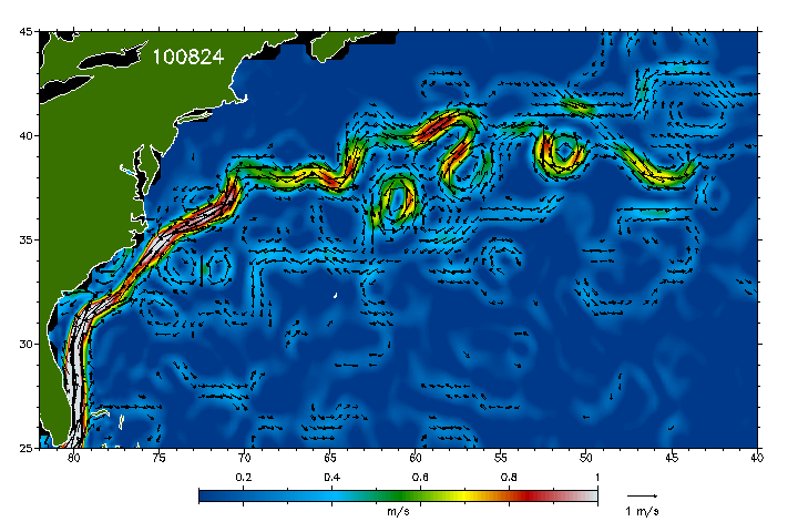
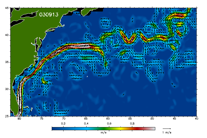
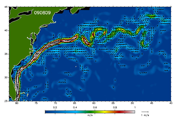
The fact is that the Gulf loop current collapse is not all that unusual. "There is a well- known history of the gulf loop current 'collapsing'," says reader Dennis Waggener. "This happened three times in 1996. It is a common event and not at all unusual."

"Satellite images in the past several weeks are showing that the Gulf Loop Current is broken and may cease to function entirely!" the stories yell. "This will result in massive climate change and possibly an ice age for Europe!"

The Loop Current begins in the Caribbean, flows around the Yucatan Peninsula and into the Gulf of Mexico, then loops around the Gulf and exits on the east side and runs between Cuba and Florida into the Atlantic where it eventually contributes to the Gulf Stream.

One article from SOTT contains an audio with a very reasonable-sounding voice telling us that "I don't want to be a fearmonger, but..."

That's like when your wife says, "I don't mean to complain, but..." And then goes ahead and complains. She just doesn't want you to notice that she’s complaining.

The voice reminds us that this is "all hard-science data" and not from "conspiracy theorists," pointing out that the information comes from the Italian Institute for Nuclear Physics and the Colorado Center for Astrodynamic Research at the University of Colorado, Boulder.

The Loop Current keeps Europe relatively warm and livable, not buried beneath three miles of ice as happened to much of the American Midwest during the last ice age, says the voice.

"It is a fact is that ice ages have existed." the audio continues. Scientists suspect that the tipping point comes when the global conveyor belt (the Loop Current) stops functioning. The transition period is often very abrupt, within a couple of years. (I agree that the transition can be very abrupt.)

The loop current has broken, the audio continues. This is "unprecedented." It may be a temporary phenomenon, or it may be permanent. It may cause irreparable damage, and it may be caused by millions and millions of gallons of oil pouring into the gulf. It may generate a chain reaction of unpredictable critical phenomena and instabilities. It may have serious consequences." (Did you notice how many times they used the word "may"?)

"What it portends is ... in other words... ICE AGE !! No joke."

The stories are based on theories put forth by theoretical physicist, Dr. Gianluigi Zangari of the National Institute of Nuclear Physics (INFN) in Italy. Dr. Zangari thinks the massive amount of oil from the BP Oil Disaster has resulted in a dramatic weakening in the vorticity of the Gulf Stream and North Atlantic Current, and a reduction in North Atlantic water temperatures of 10C.

It is a university level physics experiment to use a tub of cool water and inject a colored stream of warm water into it, the stories say. You can see the boundary layers of the stream. If you add oil to the tub it breaks down the boundary layers and effectively destroys the current vorticity. This is what is happening (supposedly) in the Gulf of Mexico and the Atlantic Ocean.

The entire 'river of warm water' that flows from the Caribbean to the edges of Western Europe is (supposedly) dying due to the approximately two million gallons of Corexit that BP used to hide the scale of oil spill. The Corexit, plus several million gallons of other dispersants, have (supposedly) caused the over two hundred million gallons of crude oil that gushed from the BP wellhead to mostly sink to the bottom of the ocean.

There are several names to the themoregulation 'river of warm water' that keeps the Northern Hemisphere from going into a new Ice Age.

Once the Loop Current leaves the Keys, it flows up the East Coast of America (Florida, Georgia, South Carolina, and part of North Carolina) to the Outer Banks. At the Outer Banks the current heads east into the North Atlantic where it is known as the Gulf Stream. Eventually the Gulf Stream becomes the North Atlantic Current, which itself eventually becomes the Norway Current and the Canary Current.

This 'river of warm water' is part of a much larger system that includes the Atlantic South Equatorial Current, which flows north along the coast of Brazil (the North Brazil Current), where it becomes the Caribbean Current, then is renamed the Yucatan Current as it flows north into the Yucatan Channel. This entire system is one of the main global themoregulation processes that regulates the planet's temperatures.

Many of the stories include a graphic from Wikipedia showing the thermohaline circulation, which is sometimes called the ocean conveyor belt, other times called the great ocean conveyor, or the global conveyor belt.

Now let me ask you. How can this current possibly stop? It is caused by the rotation of the earth. Unless the BP oil spill can make our planet stop turning on its axis (we’re rotating at the rate of 1,000 miles per hour), that current will continue to be generated.

Simply explained, the earth rotates counter-clockwise, pushing the water of the South Atlantic westward against Central and South America where it splits into two streams - the Brazil Current, flowing south, and the Gulf Stream, flowing north, the Gulf Stream being greater of the two.

I see no way that that current will cease moving. Intentionally or not, these oil-spill stories become just another way to blame humans for something that is not our fault.

And as I said, this has happened before.

George Born and Robert Leben of the University of Colorado used data from satellites TOPEX/POSEIDON and ERS-2 to track the location of the Loop Current, and to monitor the anticyclonic eddies that periodically separate from its northward intrusions into the eastern Gulf of Mexico.

They found that the Loop Current shed a series of three such anticyclonic eddies in 1996. (See http://ocean.tamu.edu/Quarterdeck/QD6.1/spin.html)

Shortly after the oil spill, Dr. Bill Deagle, MD, of The Nutrimedical Report interviewed Dr Zangari concerning the dissolution of the Loop Current, and over the next few weeks began voicing his concerns on LiveStream.com/TheNutriMedicalReportShow.

“A new Ice Age could kill 2/3 of the human race in the first year in a rapid onset,” says Dr. Deagle. “A slower onset would likely kill close to this number but simply take a handful of years.! Thank you BP; thank you President Obama, the lies and the dispersants were just great. Now if you could just direct all that hot air to the right places maybe we can avoid a icy hell in our near future.”

Dr. Deagle has interviewed me several times, and although I have the utmost respect for his brilliance, I just can’t agree with him on this subject. Regardless of how much oil is pumped into the seas, our planet is going to keep on turning.

So, to sum up. Are we headed into an ice age? Yes, I think we are.

But should we blame BP? Absolutely not.

Humans don’t cause global warming, and humans don’t cause ice ages. They're simply parts of a naturally occurring cycle - three natural cycles actually - the sunspot cycle, the Milankovitch cycle, and a third cycle known as orbital stretch.

Instead of trying to "stop global warming," or "stop the ice age," we'd be a lot better off looking for ways to cope with the inevitable.

link: http://www.iceagenow.com/BP_oil_spill_driving_us_into_an_ice_age-I_do_not_buy_it.htm
 
An Abrupt Climate Change Scenario and Its Implications for United States National Security (www.uncapsa.org/Topics/ClimateChange.pdf). This pentagon paper written in 2003 by Peter Schwartz and Doug Randal seems to put in scenario what we are currently experiencing. I quote a few excerpts that caught my attention. (highlights mine)

There is substantial evidence to indicate that significant global warming will occur during the 21st century. (…) Recent research, however, suggests that there is a possibility that this gradual global warming could lead to a relatively abrupt slowing of the ocean's thermohaline conveyor, which could lead to harsher winter weather conditions, sharply reduced soil moisture, and more intense winds in certain regions that currently provide a significant fraction of the world’s food production. With inadequate preparation, the result could be a significant drop in the human carrying capacity of the Earth’s environment.


The research suggests that once temperature rises above some threshold, adverse weather conditions could develop relatively abruptly, with persistent changes in the atmospheric circulation causing drops in some regions of 5-10 degrees Fahrenheit in a single decade. Paleoclimatic evidence suggests that altered climatic patterns could last for as much as a century, as they did when the ocean conveyor collapsed 8,200 years ago, or, at the extreme, could last as long as 1,000 years as they did during the Younger Dryas, which began about 12,700 years ago.

Even the most sophisticated models cannot predict the details of how the climate change will unfold, which regions will be impacted in which ways, and how governments and society might respond. However, there appears to be general agreement in the scientific community that an extreme case like the one depicted below is not implausible. Many scientists would regard this scenario as extreme both in how soon it develops, how large, rapid and ubiquitous the climate changes are. But history tells us that sometimes the extreme cases do occur,

In the climate change disruption scenario proposed here, we consider a period of gradual warming leading to 2010 and then outline the following ten years, when like in the 8,200 event, an abrupt change toward cooling in the pattern of weather conditions change is assumed to occur.

After roughly 60 years of slow freshening, the thermohaline collapse begins in 2010, disrupting the temperate climate of Europe, which is made possible by the warm flows of the Gulf Stream (the North A tlantic arm of the global thermohaline conveyor). Ocean circulation patterns change, bringing less warm water north and causing an immediate shift in the weather in Northern Europe and eastern North America. The North A tlantic Ocean continues to be affected by fresh water coming from melting glaciers, Greenland’s ice sheet, and perhaps most importantly increased rainfall and runoff. Decades of high-latitude warming cause increased precipitation and bring additional fresh water to the salty, dense water in the North, which is normally affected mainly by warmer and saltier water from the Gulf Stream. That massive current of warm water no longer reaches far into the North A tlantic. The immediate climatic effect is cooler temperatures in Europe and throughout much of the Northern H emisphere and a dramatic drop in rainfall in many key agricultural and populated areas. However, the effects of the collapse will be felt in fits and starts, as the traditional weather patterns re-emerge only to be disrupted again—for a full decade.
 
I've read Felix's two books and, while he has some really good points and ideas, he is clearly part of the disinfo as he pooh poohs raucously any idea of cometary impacts.
 
Another research on periodicity of such eddies occurrences dated 1994:

http://www.agu.org/journals/ABS/1995/95JC00141.shtml

JOURNAL OF GEOPHYSICAL RESEARCH, VOL. 100, NO. C5, PP. 8655-8659, 1995
doi:10.1029/95JC00141

An updated evaluation of the Loop Current's eddy-shedding frequency

Fred M. Vukovich

Science Applications International Corporation, Raleigh, North Carolina

The Loop Current's eddy-shedding frequency was reevaluated using two existing data sets which were updated with 5 years of additional data. The data sets are a 22-year data set (1972–1993) on the eddy-shedding period and a 17-year data set (1977–1993) of the monthly averaged distance between the northern boundary of the Loop Current and the 30°N latitude line. Only Loop Current eddies having diameters larger than 250 km were considered in this study The histogram of the eddy-shedding periods indicated that there is a primary mode (9 months) and a secondary mode (14 months). The range in the data is from 6.0 to 17 months, and the average period is 11 months, with a standard deviation of ±3 months. In the histogram of the eddy-shedding periods the frequency of occurrence for the 11-month period is smaller than those for the primary and secondary modes. However, the 11-month period will have a frequency of occurrence identical to the secondary mode, with only one more occurrence of the 11-month period and identical to the primary mode, with two more occurrences. The spectrum of the Loop Current's northern boundary displacements indicated that the predominant period was 11.1 months, which conformed to the average separation period.

Received 23 June 1994; accepted 16 December 1994; .

Citation: Vukovich, F. M. (1995), An updated evaluation of the Loop Current's eddy-shedding frequency, J. Geophys. Res., 100(C5), 8655–8659, doi:10.1029/95JC00141.
 
Back
Top Bottom