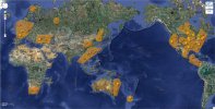
[Sinkholes] creating a google map pinpointing all of them for 2012.

HowToBe said:
Here's one from July 16th in the U.S. state of Colorado: http://www.canoncitydailyrecord.com/news/colorado/ci_21086762/sinkhole-forces-courage-classic-route-change
HowTobe : added.

angelburst29 : do you want me to make this figure on the map in any way ? :)

Have a good weekend guys :)
 
Hi Ekios,

You already logged the August 13, 2012 Louisiana Sinkhole.

I was only adding an update to the conditions surrounding the Sinkhole, which is expanding and located near a hollowed out Salt Dome, used to store drums of various chemicals.

A Hazmat Crew have been monitoring air quality (gas leaks) and bubbling, plus any signs of a cave-in or partial collapse of the Salt Dome. Any seismic activity is a concern.
 
There's an article on SOTT I just saw that's a follow-up to Brooklyn sinkhole from June 28, 2012. In case it might be of interest to this thread:

http://www.sott.net/articles/show/251264-Over-two-months-later-Brooklyn-sinkhole-grows-to-70-foot-deep-cavity-outgassing-horrible-smell-that-makes-residents-sick
 
It is possible to make similar thread for meteorites and such sightings as it increase?
 
Kaigen said:
It is possible to make similar thread for meteorites and such sightings as it increase?

I was thinking the same.

Considering the increasing trend of comet/meteor impacts (through entire solar system for instance) it could be interesting to put all data together (unless there is already such thing somewhere).

If I had more 'time' I would propose myself to work on this but for the next 1-3 weeks, I'll be quite busy.

Anyhow, we'll see by then.

Peace.
 
Good!

I can see that you've added up the sinkholes I was talking about in Québec, Ekios.

Thanks!
 
Hi Ekios, I just wanted to add another update on the August 13, 2012 Louisiana sinkhole.
It continues to grow in size.

Louisiana sinkholes merging together - 14 plus bubbling locations

http://beforeitsnews.com/alternative/2012/09/louisiana-sinkholes-merging-together-14-plus-bubbling-locations-must-watch-this-2472128.html
(Two short video's.)
 
Thanks :)

I don't understand why I stopped getting the notifications emails here :huh:

@JayMark : wouailcom' ;D
 
I realize this thread was set up to log sinkholes and their locations ......

And it's not my intent to create "noise" by logging updates on the Louisiana Sinkhole but I sense "something seriously wrong here" on top of - what has already been reported.

I envision, a massive radioactive explosion, several miles wide, setting off a fault line tremor that splits a massive trench, that eventually makes it's way down to the Gulf of Mexico. (Maybe, I should have put this in the dream section?)

Anyways, the latest report suggests - permits were applied for - to dispose radioactive (fracking) waste in the cavern along with all the other barrels of various chemicals. Bubbles and gas are surfacing 4-5 miles away with the same smell of rotten "roadkill" as one official described it.

When the sinkhole first appeared, officials called for evacuations. I pray, those people went back to collect their belongings and high tailed it out of there!

http://enenews.com/legal-expert-applied-permits-dispose-radioactive-other-waste-cavern-below-giant-sinkhole-material-leaking-audio

Tuesday, October 02, 2012

Stuart Smith, Attorney: It’s very similar to what happened in the Deepwater Horizon [Gulf of Mexico] disaster where these operations are being conducted deep underground in the blind so to speak. They applied for permits to dispose of radioactive and other waste claiming it was safe, now everything is up in the air and the material is leaking into the environment.
Full broadcast here

New flyover footage shows grass road is dissolving into giant Louisiana sinkhole (VIDEO) October 2, 2012

Hydrocarbons could have breached bottom of cavern — Oil detected on top of giant sinkhole (VIDEOS) October 1, 2012

Officials: Gas pressure is increase in aquifer near giant sinkhole — Trying to relieve buildup for ‘public safety’ — Seismic activity related to pressure? (VIDEOS) October 1, 2012

http://enenews.com/officials-smell-getting-worse-around-giant-sinkhole-lot-complaints-residents-report-health-problems-videos

Official: Gas coming up 4.5 miles away is “very, very similar” to gas near giant Louisiana sinkhole – “That would be very remarkable” (VIDEO) September 29, 2012
 
Another update on the Louisiana Bayou Corne Sinkhole of August 13th.

Mysterious gas bubbles plaguing Bayou Corne sinkhole area are also increasing at Lake Peigneur, 80 miles west of the sinkhole.

http://www.examiner.com/article/senator-louisiana-sinkhole-a-catastrophic-lake-peigneur-genocide-progress?cid=PROD-redesign-right-next

32 years ago, in 1980 at Lake Peigneur, an oil and gas company were drilling for oil when a 14 inch drill bit jammed and penetrated a Salt Dome Cavern underneath the Lake. 55 Salt Miners were working in the area when water started gushing in, mixing with the salt. The miners were able to evaculate to safety while Lake Peigneur turned into a giant whirlpool, sucking barges and oil tankers into the hole. A local fisherman barely made it to shore.

Quote from article:

"Bayou Corne’s sinkhole is now caving in a whirlpool clockwise fashion as it
threatens another major source of south Louisiana’s drinking water."

“Bayou Corne is a manmade disaster, and even scientists are finding it very complex and very serious. Lake Peigneur, Vermilion – Iberia Parish, now has bubbling and they don’t know what’s causing this."

"The DNR has continued giving permits to companies to store materials in salt caverns, even radioactive material, as it granted Texas Brine to inject into its now collapsing cavern near the sinkhole. That radium, 15 times over state limit, hydrocarbons, gas and other contaminants, could reach the Mississippi River Alluvial Aquifer and poison drinking water."

"Gas bubbling in Bayou Corne and Grand Bayou sinkhole vicinity has now increased to 20 sites, east and west of the disaster area. Seismic activity has also increased."

"The U.S. Geological Survey senior adviser for earthquake and geologic hazards said late last week that USGS consensus is that the Assumption Parish recent seismic activity is a consequence of the sinkhole area salt cavern collapse, not the cause of it and the sinkhole."

Video of the 1980 Lake Peigneur whirlpool incident:
http://beforeitsnews.com/earthquakes/2012/10/senator-sinkhole-genocide-in-progress-urgent-cover-up-continues-earthquake-monitors-taken-off-line-2445376.html

Also of interest, LA sinkhole earthquake montors "off-line."
 
An update on the Louisiana Sinkhole.

Oct. 11, 2012
Gas pipleline found floating in giant sinkhole (photo).
http://enenews.com/gas-pipeline-found-floating-on-surface-of-giant-sinkhole-photos

“Emergency response” for butane cavern nearest giant sinkhole — 40-foot high flames seen during flaring — Officials don’t know what happened

[...] Butane burned off early Thursday morning at Crosstex Energy LP’s cavern facility east of the sinkhole, shutting La. 70 South for about 10 minutes, parish officials said.

Crosstex of Dallas has two caverns inside the Napoleonville Dome just east of the sinkhole.

Officials with the parish and the company, Crosstex Energy LP, said Thursday that the flare was not related to the sinkhole but part of normal operations by equipment designed to burn off the gas. [...]

However, the company planned by early Thursday evening to resume flaring through the night to remove butane from lines connected to the caverns and do repairs [...]

Reported to parish officials about 6 a.m., the Thursday morning flare reached a reported 40 feet for about 10 minutes and gradually lowered before going out, Boudreaux said.

Jill McMillan, spokeswoman for Crosstex, said the flaring was an emergency response mechanism related to Crosstex’s Cavern No. 2, which is closer to the sinkhole of the company’s two caverns.

She said company officials are working on why flaring happened.

After the sinkhole’s emergence, Crosstex agreed to move butane from Cavern No. 2 to Cavern No. 1, as a precaution, so the gas is farther from the sinkhole. That process remains under way, she said.

“It’s going as expected,” McMillan said.

This situation began around the same time that the gas pipeline floated to the sinkhole's surface.


*** In this link, a blogger (Paveway111) gives some explaination of the fault line and seismic activity connected to the sinkhole.

http://enenews.com/legal-expert-incredibly-dangerous-situation-louisiana-local-officials-very-concerned-gas-could-burst-ground-explosive-force

Here's the basic model put forth of the seismic connection.

A long, long time ago… the Gulf of Mexico was cut off from the ocean and dried up, leaving behind tens-of-kilometers of salt. Then South America decided it didn't like North America and the two split up, right in the middle of the GOM.

http://oceanexplorer.noaa.gov/explorations/02mexico/background/brinepool/media/gulf_salt.html

Later on the GOM was reconnected with the oceans. The Yucatan sort of spun counter-clockwise, putting little cracks in the big GOM crack.

http://www.aapg.org/explorer/geophysical_corner/2000/gpc10fig2.cfm

Meanwhile, sand and mud and dead dinosaurs piled up on the Louann mother salt. The Louann Basin was squashed towards the south, and a bunch of salt domes poked up where the salt was really thick. That's where the GOM shelf looks like the moon:

http://goo.gl/maps/arnmf

But beneath the Louann salt is a Gulf of Mexico tectonic plate about the same size that's also moving South. All the squishing and movin' south made a fairly active fault along the ancient continental shelf edge.

That fault pretty much connects the Macondo well, Lake Pontchartrain, Baton Rouge, and the sinkhole of death. Further on, the fault runs through Hot Wells LA - where the New Madrid fault may start [/b (=bad)

http://www.aapg.org/explorer/2002/11nov/rift_zone.cfm

Theory: Dead dinos and methane hydrates are not the cause. They're just along for the ride.

*** As for the BP's Macondo well....

Pilot films "substantial amounts of fresh looking oil" around BP's Macondo Reservoir

http://enenews.com/watch-pilot-substantial-amounts-of-fresh-looking-oil-around-bps-macondo-reservoir-photos-video

[...]

MC252 and surroundings, home to BP’s infamous well and the Macondo reservoir. We found what we were looking for, and much that we had hoped not to find.

[...]

What we did not expect was to see that kind of rainbow sheen and substantial amounts of fresh-looking oil around the Macondo reservoir. But find it we did
 
This one is from 2011, so I don't know if you'll want to add it. Just happened across it while looking for something else.

_http://newyork.cbslocal.com/2011/10/31/80-year-old-man-falls-into-8-foot-sinkhole-outside-his-oceanside-home/
 
Hi Ekios. Picked up a sink hole about 30 k wsw of where I live -Grahamstown, E Cape, SA - and remembered this thread. Here's the link:

http://sawdis1.blogspot.com/

Scroll down for the picture. Translation of the text is: "The Eastern Cape disaster centre said on Sunday that rain is still causing trouble in the Eastern Cape and sections of the N2 have been closed to traffic. Captain John Fobian said that there is a big hole, about 25m wide and 50m deep on the N2 close to the Pumba Wildlife reserve between Port Elizabeth and Grahamstown. The road is closed and traffic from Port Elizabeth has been sent via Cradock and Cookhouse to Gtn and East London


Afrikaans: Reën maak steeds amok in die Oos-Kaap en dele van die N2 is vir verkeer gesluit, het die Oos-Kaapse rampbestuursentrum Sondag gesê.

"Daar is 'n groot gat, sowat 25 m wyd en 50 m diep op die N2, by die Pumba-wildplaas tussen Port Elizabeth en Grahamstad, het kapt. John Fobian gesê.

"Die pad is gesluit en verkeer word vanaf Port Elizabeth na die Cradock-pad N10 rondom Cookhouse en terug na Grahamstad of Oos-Londen herlei."

I hear that our current rains have broken all records.

Hope this helps with the compilation.
 
Hey guys, thx for the informations here, i'm going to deal with it right away :)

Again : Thank you :)

Edit : add them both !
 
Back
Top Bottom